Bridge Statistics for Lamar, Colorado (CO)
Condition, Traffic, Stress, Structural Evaluation, Project Costs
- National Bridge Inventory (NBI) Statistics
- 31Number of bridges
- 253ft / 76.7mTotal length
- $1,690,000Total costs
- 62,829Total average daily traffic
- 10,515Total average daily truck traffic
- 77,451Total future (year 2038) average daily traffic
- National Bridge Inventory (NBI) Registered Bridges for Lamar
- No street view available for this location
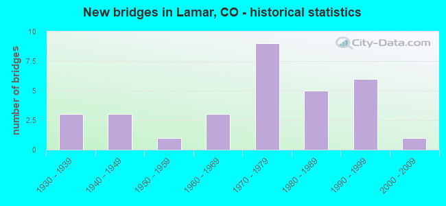
- New bridges - historical statistics
- 31930-1939
- 31940-1949
- 11950-1959
- 31960-1969
- 91970-1979
- 51980-1989
- 61990-1999
- 12000-2009

- Reconstructed bridges - Historical Statistics
- 11950-1959
- 11960-1969
- 01970-1979
- 01980-1989
- 31990-1999


- Bridge Condition - Deck
- 20.0%Good
- 36.0%Satisfactory
- 28.0%Fair
- 12.0%Poor
- 4.0%Serious

- Bridge Condition - Superstructure
- 16.0%Good
- 72.0%Satisfactory
- 8.0%Fair
- 4.0%Poor

- Bridge Condition - Substructure
- 4.0%Very good
- 4.0%Good
- 40.0%Satisfactory
- 48.0%Fair
- 4.0%Serious

- Bridge Condition - Channel
- 12.9%Very good
- 41.9%Good
- 41.9%Satisfactory
- 3.2%Fair

- Bridge Condition - Culverts
- 50.0%Good
- 33.3%Satisfactory
- 16.7%Fair
Find on map >> Show street view
Structure Number: L-26-AZ, Location: 2.2 MI SOUTH OF KORNMAN (Lat: 38.121608, Lng: -102.618108), Route carried "on" structure: County highway , Year Built: 1949, Status: Open, Structure Length: 1.77m (5.81ft), Average Daily Traffic: 3,232 (year 2018), Truck Traffic: 6%, Average Future Daily Traffic: 4,590 (year 2038), Design Load: H 20, Features Intersected: AMITY CANAL, Facility Carried by Structure: CNTY RD_OLD SH 196
Minimum Vertical Clearance: 30+ m (98+ ft), Kilometerpoint: 15.257, Lanes on structure: 2, Owner: County Highway Agency, Approaching Roadway Width: 7.0m (23.0ft), Skew: 3 degrees, Material/Design: Steel, Design/Construction: Stringer/Multi-beam, Number Of Spans In Main Unit: 1, Length of Maximum Span: 15.8m (51.8ft), Curb-To-Curb Width: 7.9m (25.9ft), Out-to-Out Width: 10.0m (32.8ft)
Condition: Deck: Satisfactory, Superstructure: Good, Substructure: Satisfactory, Channel: Good, Operating Rating: 42.0 metric tons, Method Used To Determine Operating Rating: Load Factor (LF), Inventory Rating: 25.2 metric tons, Method Used To Determine Inventory Rating: Load Factor (LF), Structural Evaluation: Equal to present minimum criteria, Deck Geometry: High priority of corrective action, Waterway Adequacy: Equal to present desirable criteria, Approach Roadway Alignment: Equal to present desirable criteria, Designated Inspection Frequency: Every 24 months, Inspection Date: April 2021, Deck Structure Type: Concrete Cast-file-Place, Wearing Surface/Protective System: Wearing Surface: Bituminous
Find on map >> Show street view
Structure Number: L-26-A_MINOR, Location: IN LAMAR (Lat: 38.071231, Lng: -102.617661), Route carried "on" structure: US 287A, Year Built: 1947, Year Reconstructed: 1968, Status: Open, Structure Length: 0.67m (2.20ft), Average Daily Traffic: 9,200 (year 2020), Truck Traffic: 15%, Average Future Daily Traffic: 12,328 (year 2040), Design Load: H 20, Features Intersected: FORT BENT CANAL, Facility Carried by Structure: US 287 ML
Minimum Vertical Clearance: 30+ m (98+ ft), Kilometerpoint: 123.042, Lanes on structure: 6, Base Highway Network: Yes, Owner: State Highway Agency, Approaching Roadway Width: 23.8m (78.1ft), Skew: 33 degrees, Material/Design: Concrete, Design/Construction: Slab, Number Of Spans In Main Unit: 1, Length of Maximum Span: 6.1m (20.0ft), Curb or Sidewalk Widths: Left: 1.1m (3.6ft), Right: 1.1m (3.6ft), Curb-To-Curb Width: 25.6m (84.0ft), Out-to-Out Width: 28.7m (94.2ft)
Condition: Deck: Satisfactory, Superstructure: Satisfactory, Substructure: Satisfactory, Channel: Good, Operating Rating: 39.6 metric tons, Method Used To Determine Operating Rating: Load Factor (LF), Inventory Rating: 23.8 metric tons, Method Used To Determine Inventory Rating: Load Factor (LF), Structural Evaluation: Somewhat better than minimum adequacy, Deck Geometry: Somewhat better than minimum adequacy, Waterway Adequacy: Equal to present desirable criteria, Approach Roadway Alignment: Equal to present desirable criteria, Designated Inspection Frequency: Every 24 months, Inspection Date: January 2022, Deck Structure Type: Concrete Cast-file-Place, Wearing Surface/Protective System: Wearing Surface: Bituminous
Find on map >> Show street view
Structure Number: L-26-BO, Location: 3.8 MI W of Lamar (Lat: 38.111608, Lng: -102.654783), Route carried "on" structure: US 50B, Year Built: 1979, Status: Open, Structure Length: 0.70m (2.30ft), Average Daily Traffic: 7,800 (year 2020), Truck Traffic: 24%, Average Future Daily Traffic: 8,892 (year 2040), Design Load: HS 20, Features Intersected: VISTA DEL RIO CANAL, Facility Carried by Structure: US 50 ML
Minimum Vertical Clearance: 30+ m (98+ ft), Kilometerpoint: 186.542, Lanes on structure: 4, Base Highway Network: Yes, Owner: State Highway Agency, Approaching Roadway Width: 25.0m (82.0ft), Skew: 12 degrees, Material/Design: Concrete, Design/Construction: Culvert, Number Of Spans In Main Unit: 2, Length of Maximum Span: 3.4m (11.2ft), Out-to-Out Width: 51.2m (168.0ft)
Condition: Channel: Satisfactory, Culverts: Fair, Operating Rating: 36.3 metric tons, Method Used To Determine Operating Rating: Field evaluation and documented engineering judgment, Inventory Rating: 32.7 metric tons, Method Used To Determine Inventory Rating: Field evaluation and documented engineering judgment, Structural Evaluation: Somewhat better than minimum adequacy, Waterway Adequacy: Equal to present desirable criteria, Approach Roadway Alignment: Equal to present desirable criteria, Designated Inspection Frequency: Every 24 months, Inspection Date: Febuary 2022
Find on map >> Show street view
Structure Number: L-26-BV, Location: 1.4 MI E OF JCT US 287 (Lat: 38.089297, Lng: -102.594383), Route carried "on" structure: US 50B, Year Built: 1987, Status: Open, Structure Length: 0.67m (2.20ft), Average Daily Traffic: 2,200 (year 2020), Truck Traffic: 13%, Average Future Daily Traffic: 2,244 (year 2040), Design Load: HS 20+Mod, Features Intersected: LAMAR CANAL, Facility Carried by Structure: US 50 ML
Minimum Vertical Clearance: 30+ m (98+ ft), Kilometerpoint: 194.927, Lanes on structure: 4, Base Highway Network: Yes, Owner: State Highway Agency, Approaching Roadway Width: 18.9m (62.0ft), Material/Design: Concrete, Design/Construction: Culvert, Number Of Spans In Main Unit: 1, Length of Maximum Span: 6.7m (22.0ft), Curb-To-Curb Width: 18.0m (59.1ft), Out-to-Out Width: 22.9m (75.1ft)
Condition: Channel: Very good, Culverts: Satisfactory, Operating Rating: 36.3 metric tons, Method Used To Determine Operating Rating: Field evaluation and documented engineering judgment, Inventory Rating: 32.7 metric tons, Method Used To Determine Inventory Rating: Field evaluation and documented engineering judgment, Structural Evaluation: Equal to present minimum criteria, Deck Geometry: Somewhat better than minimum adequacy, Waterway Adequacy: Equal to present desirable criteria, Approach Roadway Alignment: Equal to present desirable criteria, Designated Inspection Frequency: Every 24 months, Inspection Date: Febuary 2022
Find on map >> Show street view
Structure Number: L-26-BW, Location: 2 MI N OF LAMAR (Lat: 38.104542, Lng: -102.618208), Route carried "on" structure: US 50B, Year Built: 1989, Status: Open, Structure Length: 17.33m (56.86ft), Average Daily Traffic: 4,700 (year 2020), Truck Traffic: 19%, Average Future Daily Traffic: 5,311 (year 2040), Design Load: HS 20+Mod, Features Intersected: ARKANSAS RIVER, Facility Carried by Structure: US 50 ML WBND
Minimum Vertical Clearance: 30+ m (98+ ft), Kilometerpoint: 190.896, Lanes on structure: 2, Base Highway Network: Yes, Owner: State Highway Agency, Approaching Roadway Width: 11.6m (38.1ft), Material/Design: Prestressed concrete continuous, Design/Construction: Stringer/Multi-beam, Number Of Spans In Main Unit: 5, Length of Maximum Span: 38.5m (126.3ft), Curb-To-Curb Width: 11.6m (38.1ft), Out-to-Out Width: 12.3m (40.4ft)
Condition: Deck: Good, Superstructure: Good, Substructure: Satisfactory, Channel: Satisfactory, Operating Rating: 35.6 metric tons, Method Used To Determine Operating Rating: Load and Resistance Factor Rating (LRFR) rating reported by rating factor(RF) method using HL-93 loadings, Inventory Rating: 25.9 metric tons, Method Used To Determine Inventory Rating: Load and Resistance Factor Rating (LRFR) rating reported by rating factor(RF) method using HL-93 loadings, Structural Evaluation: Equal to present minimum criteria, Deck Geometry: Better than present minimum criteria, Waterway Adequacy: Equal to present desirable criteria, Approach Roadway Alignment: Equal to present desirable criteria, Designated Inspection Frequency: Every 24 months, Inspection Date: Febuary 2020, Deck Structure Type: Concrete Cast-file-Place, Wearing Surface/Protective System: Wearing Surface: Bituminous, Membrane: Preformed Fabric
Find on map >> Show street view
Structure Number: L-26-E, Location: IN LAMAR (Lat: 38.096286, Lng: -102.619675), Route carried "on" structure: US 50B, Year Built: 1931, Year Reconstructed: 1962, Status: Open, Structure Length: 0.73m (2.40ft), Average Daily Traffic: 13,000 (year 2020), Truck Traffic: 13%, Average Future Daily Traffic: 15,340 (year 2040), Design Load: H 15, Features Intersected: LAMAR CANAL, Facility Carried by Structure: US 50 ML
Minimum Vertical Clearance: 30+ m (98+ ft), Kilometerpoint: 191.826, Lanes on structure: 5, Base Highway Network: Yes, Owner: State Highway Agency, Approaching Roadway Width: 21.3m (69.9ft), Skew: 21 degrees, Material/Design: Concrete, Design/Construction: Slab, Number Of Spans In Main Unit: 1, Length of Maximum Span: 6.7m (22.0ft), Curb or Sidewalk Widths: Left: 1.4m (4.6ft), Right: 0.0m, Curb-To-Curb Width: 24.4m (80.1ft), Out-to-Out Width: 26.7m (87.6ft)
Condition: Deck: Satisfactory, Superstructure: Satisfactory, Substructure: Fair, Channel: Very good, Operating Rating: 45.4 metric tons, Method Used To Determine Operating Rating: Load Factor (LF), Inventory Rating: 25.6 metric tons, Method Used To Determine Inventory Rating: Load Factor (LF), Structural Evaluation: Somewhat better than minimum adequacy, Deck Geometry: Superior to present desirable criteria, Waterway Adequacy: Equal to present desirable criteria, Approach Roadway Alignment: Equal to present desirable criteria, Designated Inspection Frequency: Every 24 months, Inspection Date: Febuary 2022, Deck Structure Type: Concrete Cast-file-Place, Wearing Surface/Protective System: Wearing Surface: Bituminous
Find on map >> Show street view
Structure Number: L-26-H, Location: In Lamar (Lat: 38.106172, Lng: -102.618497), Route carried "on" structure: US 50B, Year Built: 1967, Status: Open, Structure Length: 17.36m (56.96ft), Average Daily Traffic: 4,700 (year 2020), Truck Traffic: 19%, Average Future Daily Traffic: 5,311 (year 2040), Design Load: HS 20+Mod, Features Intersected: ARKANSAS RIVER, Facility Carried by Structure: US 50 EBND
Minimum Vertical Clearance: 30+ m (98+ ft), Kilometerpoint: 190.715, Lanes on structure: 2, Base Highway Network: Yes, Owner: State Highway Agency, Approaching Roadway Width: 11.3m (37.1ft), Skew: 10 degrees, Material/Design: Steel, Design/Construction: Stringer/Multi-beam, Number Of Spans In Main Unit: 9, Length of Maximum Span: 18.9m (62.0ft), Curb-To-Curb Width: 8.5m (27.9ft), Out-to-Out Width: 9.8m (32.2ft)
Condition: Deck: Fair, Superstructure: Satisfactory, Substructure: Fair, Channel: Satisfactory, Operating Rating: 50.8 metric tons, Method Used To Determine Operating Rating: Load Factor (LF), Inventory Rating: 30.0 metric tons, Method Used To Determine Inventory Rating: Load Factor (LF), Structural Evaluation: Somewhat better than minimum adequacy, Deck Geometry: High priority of corrective action, Waterway Adequacy: Equal to present desirable criteria, Approach Roadway Alignment: Equal to present desirable criteria, Length Of Structure Improvement: 17.38m (57.02ft), Designated Inspection Frequency: Every 24 months, Inspection Date: December 2020, Bridge Improvement Cost: $2,000, Total Project Cost: $3,000, Deck Structure Type: Concrete Cast-file-Place, Wearing Surface/Protective System: Wearing Surface: Monolithic Concrete
Find on map >> Show street view
Structure Number: L-26-I, Location: 1.8 MI S OF LAMAR (Lat: 38.037200, Lng: -102.614997), Route carried "on" structure: US 287A, Year Built: 1947, Status: Open, Structure Length: 3.78m (12.40ft), Average Daily Traffic: 3,300 (year 2020), Truck Traffic: 52%, Average Future Daily Traffic: 4,488 (year 2040), Design Load: HS 20, Features Intersected: WILLOW CREEK, Facility Carried by Structure: US 287 ML
Minimum Vertical Clearance: 30.45m (99.90ft), Kilometerpoint: 119.254, Lanes on structure: 2, Base Highway Network: Yes, Owner: State Highway Agency, Approaching Roadway Width: 13.4m (44.0ft), Material/Design: Steel, Design/Construction: Stringer/Multi-beam, Number Of Spans In Main Unit: 3, Length of Maximum Span: 12.0m (39.4ft), Curb-To-Curb Width: 9.1m (29.9ft), Out-to-Out Width: 10.9m (35.8ft)
Condition: Deck: Satisfactory, Superstructure: Good, Substructure: Satisfactory, Channel: Very good, Operating Rating: 51.2 metric tons, Method Used To Determine Operating Rating: Load Factor (LF), Inventory Rating: 30.7 metric tons, Method Used To Determine Inventory Rating: Load Factor (LF), Structural Evaluation: Equal to present minimum criteria, Deck Geometry: Meets minimum limits, Waterway Adequacy: Equal to present desirable criteria, Approach Roadway Alignment: Equal to present desirable criteria, Designated Inspection Frequency: Every 24 months, Inspection Date: July 2020, Deck Structure Type: Concrete Cast-file-Place, Wearing Surface/Protective System: Wearing Surface: Bituminous
Find on map >> Show street view
Structure Number: L-26-M, Location: 2.3 MI EAST OF LAMAR (Lat: 38.091542, Lng: -102.577450), Route carried "on" structure: US 50B, Year Built: 1936, Status: Open, Structure Length: 1.43m (4.69ft), Average Daily Traffic: 2,600 (year 2020), Truck Traffic: 16%, Average Future Daily Traffic: 2,730 (year 2040), Design Load: H 15, Features Intersected: WILLOW CREEK, Facility Carried by Structure: US 50 ML
Minimum Vertical Clearance: 30+ m (98+ ft), Kilometerpoint: 196.454, Lanes on structure: 2, Base Highway Network: Yes, Owner: State Highway Agency, Approaching Roadway Width: 12.2m (40.0ft), Material/Design: Wood or Timber, Design/Construction: Stringer/Multi-beam, Number Of Spans In Main Unit: 2, Length of Maximum Span: 7.0m (23.0ft), Curb-To-Curb Width: 9.1m (29.9ft), Out-to-Out Width: 9.4m (30.8ft)
Condition: Deck: Fair, Superstructure: Poor, Substructure: Fair, Channel: Good, Operating Rating: 37.8 metric tons, Method Used To Determine Operating Rating: Allowable Stress (AS), Inventory Rating: 24.8 metric tons, Method Used To Determine Inventory Rating: Allowable Stress (AS), Structural Evaluation: Meets minimum limits, Deck Geometry: Meets minimum limits, Waterway Adequacy: Equal to present desirable criteria, Approach Roadway Alignment: Equal to present desirable criteria, Designated Inspection Frequency: Every 24 months, Inspection Date: September 2020, Deck Structure Type: Concrete Cast-file-Place, Wearing Surface/Protective System: Wearing Surface: Bituminous
Find on map >> Show street view
Structure Number: L-26-X, Location: 4 MI EAST OF LAMAR (Lat: 38.092842, Lng: -102.544156), Route carried "on" structure: US 50B, Year Built: 1936, Status: Open, Structure Length: 2.81m (9.22ft), Average Daily Traffic: 2,600 (year 2020), Truck Traffic: 16%, Average Future Daily Traffic: 2,730 (year 2040), Design Load: H 15, Features Intersected: WILLOW CREEK OVERFLOW, Facility Carried by Structure: US 50 ML
Minimum Vertical Clearance: 30+ m (98+ ft), Kilometerpoint: 199.382, Lanes on structure: 2, Base Highway Network: Yes, Owner: State Highway Agency, Approaching Roadway Width: 11.9m (39.0ft), Skew: 4 degrees, Material/Design: Wood or Timber, Design/Construction: Stringer/Multi-beam, Number Of Spans In Main Unit: 4, Length of Maximum Span: 6.9m (22.6ft), Curb-To-Curb Width: 9.1m (29.9ft), Out-to-Out Width: 9.4m (30.8ft)
Condition: Deck: Satisfactory, Superstructure: Satisfactory, Substructure: Fair, Channel: Very good, Operating Rating: 38.2 metric tons, Method Used To Determine Operating Rating: Allowable Stress (AS), Inventory Rating: 25.4 metric tons, Method Used To Determine Inventory Rating: Allowable Stress (AS), Structural Evaluation: Somewhat better than minimum adequacy, Deck Geometry: Meets minimum limits, Waterway Adequacy: Equal to present desirable criteria, Approach Roadway Alignment: Equal to present desirable criteria, Designated Inspection Frequency: Every 24 months, Inspection Date: Febuary 2020, Deck Structure Type: Wood or Timber, Wearing Surface/Protective System: Wearing Surface: Bituminous
Find on map >> Show street view
Structure Number: LMR-1, Location: JUST WEST OF CR 9 (Lat: 38.085453, Lng: -102.597675), Route carried "on" structure: City street , Year Built: 2005, Status: Open, Structure Length: 0.66m (2.17ft), Average Daily Traffic: 292 (year 2018), Truck Traffic: 2%, Average Future Daily Traffic: 415 (year 2038), Design Load: HS 20, Features Intersected: WILLOW CREEK DRAIN, Facility Carried by Structure: COUNTY ROAD HH
Minimum Vertical Clearance: 30+ m (98+ ft), Kilometerpoint: 0.538, Lanes on structure: 2, Owner: City or Municipal Highway Agency, Approaching Roadway Width: 6.7m (22.0ft), Skew: 6 degrees, Material/Design: Concrete, Design/Construction: Culvert, Number Of Spans In Main Unit: 1, Length of Maximum Span: 6.6m (21.7ft), Out-to-Out Width: 8.2m (26.9ft)
Condition: Channel: Satisfactory, Culverts: Good, Operating Rating: 36.3 metric tons, Method Used To Determine Operating Rating: Field evaluation and documented engineering judgment, Inventory Rating: 32.7 metric tons, Method Used To Determine Inventory Rating: Field evaluation and documented engineering judgment, Structural Evaluation: Better than present minimum criteria, Waterway Adequacy: Equal to present minimum criteria, Approach Roadway Alignment: Better than present minimum criteria, Designated Inspection Frequency: Every 24 months, Inspection Date: April 2021
Find on map >> Show street view
Structure Number: LMR-1A, Location: IN LAMAR (Lat: 38.071628, Lng: -102.614761), Route carried "on" structure: City street , Year Built: 1995, Status: Open, Structure Length: 5.27m (17.29ft), Average Daily Traffic: 3,729 (year 2018), Truck Traffic: 5%, Average Future Daily Traffic: 5,296 (year 2038), Features Intersected: WILLOW CREEK, Facility Carried by Structure: MEMORIAL DRIVE
Minimum Vertical Clearance: 30+ m (98+ ft), Kilometerpoint: 0.071, Lanes on structure: 3, Owner: City or Municipal Highway Agency, Approaching Roadway Width: 10.4m (34.1ft), Skew: 3 degrees, Material/Design: Prestressed concrete, Design/Construction: Box Beam or Girders - Single/Spread, Number Of Spans In Main Unit: 2, Length of Maximum Span: 24.9m (81.7ft), Curb or Sidewalk Widths: Left: 3.0m (9.8ft), Right: 0.0m, Curb-To-Curb Width: 12.6m (41.3ft), Out-to-Out Width: 16.2m (53.1ft)
Condition: Deck: Good, Superstructure: Satisfactory, Substructure: Good, Channel: Good, Operating Rating: 36.3 metric tons, Method Used To Determine Operating Rating: Field evaluation and documented engineering judgment, Inventory Rating: 32.7 metric tons, Method Used To Determine Inventory Rating: Field evaluation and documented engineering judgment, Structural Evaluation: Equal to present minimum criteria, Deck Geometry: Meets minimum limits, Waterway Adequacy: Equal to present desirable criteria, Approach Roadway Alignment: Better than present minimum criteria, Designated Inspection Frequency: Every 24 months, Inspection Date: April 2021, Deck Structure Type: Concrete Precast Panels, Wearing Surface/Protective System: Wearing Surface: Bituminous
Find on map >> Show street view
Structure Number: LMR-2 OAK ST., Location: JUST W OF 14TH STREET (Lat: 38.085394, Lng: -102.632306), Route carried "on" structure: City street , Year Built: 1975, Status: Open, Structure Length: 1.04m (3.41ft), Average Daily Traffic: 901 (year 2018), Truck Traffic: 2%, Average Future Daily Traffic: 1,279 (year 2038), Features Intersected: GREEN BELT FLOODWAY, Facility Carried by Structure: OAK STREET
Minimum Vertical Clearance: 30+ m (98+ ft), Kilometerpoint: 0.029, Lanes on structure: 2, Owner: City or Municipal Highway Agency, Approaching Roadway Width: 7.3m (24.0ft), Skew: 1 degrees, Material/Design: Concrete, Design/Construction: Culvert, Number Of Spans In Main Unit: 3, Length of Maximum Span: 3.7m (12.1ft), Curb-To-Curb Width: 10.5m (34.4ft), Out-to-Out Width: 12.2m (40.0ft)
Condition: Channel: Satisfactory, Culverts: Good, Operating Rating: 36.3 metric tons, Method Used To Determine Operating Rating: Field evaluation and documented engineering judgment, Inventory Rating: 32.7 metric tons, Method Used To Determine Inventory Rating: Field evaluation and documented engineering judgment, Structural Evaluation: Better than present minimum criteria, Deck Geometry: Equal to present minimum criteria, Waterway Adequacy: Better than present minimum criteria, Approach Roadway Alignment: Better than present minimum criteria, Designated Inspection Frequency: Every 24 months, Inspection Date: April 2021
Find on map >> Show street view
Structure Number: LMR-3 MAPLE ST., Location: IN LAMAR (Lat: 38.091764, Lng: -102.632342), Route carried "on" structure: City street , Year Built: 1975, Status: Open, Structure Length: 1.02m (3.35ft), Average Daily Traffic: 386 (year 2018), Truck Traffic: 2%, Average Future Daily Traffic: 549 (year 2038), Features Intersected: GREEN BELT FLOODWAY, Facility Carried by Structure: MAPLE STREET
Minimum Vertical Clearance: 30+ m (98+ ft), Kilometerpoint: 1.542, Lanes on structure: 2, Owner: City or Municipal Highway Agency, Approaching Roadway Width: 9.1m (29.9ft), Material/Design: Concrete, Design/Construction: Culvert, Number Of Spans In Main Unit: 3, Length of Maximum Span: 3.7m (12.1ft), Curb-To-Curb Width: 10.4m (34.1ft), Out-to-Out Width: 12.2m (40.0ft)
Condition: Channel: Satisfactory, Culverts: Good, Operating Rating: 36.3 metric tons, Method Used To Determine Operating Rating: Field evaluation and documented engineering judgment, Inventory Rating: 32.7 metric tons, Method Used To Determine Inventory Rating: Field evaluation and documented engineering judgment, Structural Evaluation: Better than present minimum criteria, Deck Geometry: Better than present minimum criteria, Waterway Adequacy: Equal to present desirable criteria, Approach Roadway Alignment: Equal to present desirable criteria, Designated Inspection Frequency: Every 24 months, Inspection Date: April 2021
Find on map >> Show street view
Structure Number: LMR-4 CANAL RD, Location: JUST W OF 13TH STREET (Lat: 38.101906, Lng: -102.631856), Route carried "on" structure: City street , Year Built: 1976, Status: Open, Structure Length: 1.00m (3.28ft), Average Daily Traffic: 31 (year 2018), Average Future Daily Traffic: 44 (year 2038), Features Intersected: GREEN BELT FLOODWAY, Facility Carried by Structure: CANAL ROAD
Minimum Vertical Clearance: 30+ m (98+ ft), Kilometerpoint: 0.144, Lanes on structure: 2, Owner: City or Municipal Highway Agency, Approaching Roadway Width: 7.0m (23.0ft), Skew: 3 degrees, Material/Design: Concrete, Design/Construction: Culvert, Number Of Spans In Main Unit: 4, Length of Maximum Span: 1.9m (6.2ft), Out-to-Out Width: 33.4m (109.6ft)
Condition: Channel: Fair, Culverts: Satisfactory, Operating Rating: 36.3 metric tons, Method Used To Determine Operating Rating: Field evaluation and documented engineering judgment, Inventory Rating: 32.7 metric tons, Method Used To Determine Inventory Rating: Field evaluation and documented engineering judgment, Structural Evaluation: Equal to present minimum criteria, Waterway Adequacy: Equal to present minimum criteria, Approach Roadway Alignment: Equal to present minimum criteria, Designated Inspection Frequency: Every 24 months, Inspection Date: April 2021
Find on map >> Show street view
Structure Number: LMR-5A, Location: JUST S OF SH 50 (Lat: 38.090753, Lng: -102.588456), Route carried "on" structure: City street , Year Built: 1995, Status: Open, Structure Length: 1.53m (5.02ft), Average Daily Traffic: 247 (year 2018), Average Future Daily Traffic: 351 (year 2038), Features Intersected: WILLOW CREEK DRAIN, Facility Carried by Structure: COUNTY ROAD 9.3
Minimum Vertical Clearance: 30+ m (98+ ft), Kilometerpoint: 3.191, Lanes on structure: 2, Owner: City or Municipal Highway Agency, Approaching Roadway Width: 7.9m (25.9ft), Material/Design: Steel, Design/Construction: Stringer/Multi-beam, Number Of Spans In Main Unit: 1, Length of Maximum Span: 14.4m (47.2ft), Curb-To-Curb Width: 13.7m (44.9ft), Out-to-Out Width: 13.8m (45.3ft)
Condition: Deck: Fair, Superstructure: Satisfactory, Substructure: Satisfactory, Channel: Good, Operating Rating: 54.7 metric tons, Method Used To Determine Operating Rating: Load Factor (LF), Inventory Rating: 32.8 metric tons, Method Used To Determine Inventory Rating: Load Factor (LF), Structural Evaluation: Equal to present minimum criteria, Deck Geometry: Superior to present desirable criteria, Waterway Adequacy: Better than present minimum criteria, Approach Roadway Alignment: Equal to present minimum criteria, Designated Inspection Frequency: Every 24 months, Inspection Date: May 2021, Deck Structure Type: Corrugated Steel, Wearing Surface/Protective System: Wearing Surface: Bituminous
Find on map >> Show street view
Structure Number: LMR-7, Location: JUST S. OF SH 50 (Lat: 38.091139, Lng: -102.581150), Route carried "on" structure: City street , Year Built: 1975, Status: Open, Structure Length: 0.68m (2.23ft), Average Daily Traffic: 81 (year 2018), Average Future Daily Traffic: 114 (year 2038), Features Intersected: WILLOW CREEK DRAIN, Facility Carried by Structure: COUNTY ROAD 9.6
Minimum Vertical Clearance: 30+ m (98+ ft), Kilometerpoint: 196.128, Lanes on structure: 2, Owner: City or Municipal Highway Agency, Approaching Roadway Width: 6.1m (20.0ft), Material/Design: Steel, Design/Construction: Stringer/Multi-beam, Number Of Spans In Main Unit: 1, Length of Maximum Span: 6.1m (20.0ft), Curb-To-Curb Width: 5.9m (19.4ft), Out-to-Out Width: 6.1m (20.0ft)
Condition: Deck: Fair, Superstructure: Satisfactory, Substructure: Fair, Channel: Good, Operating Rating: 8.5 metric tons, Method Used To Determine Operating Rating: Load Factor (LF), Inventory Rating: 5.1 metric tons, Method Used To Determine Inventory Rating: Load Factor (LF), Structural Evaluation: High priority of replacement, Deck Geometry: Meets minimum limits, Waterway Adequacy: Equal to present minimum criteria, Approach Roadway Alignment: Equal to present minimum criteria, Bridge Posting: Required (Relationship of Operating Rating to Maximum Legal Load: > 39.9% below), Length Of Structure Improvement: 1.31m (4.30ft), Designated Inspection Frequency: Every 24 months, Inspection Date: April 2021, Bridge Improvement Cost: $440,000, Roadway Improvement Cost: $44,000, Total Project Cost: $550,000 ( Estimate for 2019), Deck Structure Type: Corrugated Steel, Wearing Surface/Protective System: Wearing Surface: Bituminous
Find on map >> Show street view
Structure Number: PR10-9-30.1-103, Location: .2 MI S OF SH 50 (Lat: 38.085750, Lng: -102.588278), Route carried "on" structure: County highway , Year Built: 1993, Status: Open, Structure Length: 1.24m (4.07ft), Average Daily Traffic: 257 (year 2018), Average Future Daily Traffic: 364 (year 2038), Features Intersected: LAMAR CANAL, Facility Carried by Structure: COUNTY ROAD 9.4
Minimum Vertical Clearance: 30+ m (98+ ft), Kilometerpoint: 2.660, Lanes on structure: 2, Owner: County Highway Agency, Approaching Roadway Width: 7.9m (25.9ft), Skew: 1 degrees, Material/Design: Steel, Design/Construction: Stringer/Multi-beam, Number Of Spans In Main Unit: 1, Length of Maximum Span: 11.6m (38.1ft), Curb-To-Curb Width: 9.7m (31.8ft), Out-to-Out Width: 9.8m (32.2ft)
Condition: Deck: Fair, Superstructure: Satisfactory, Substructure: Fair, Channel: Good, Operating Rating: 51.6 metric tons, Method Used To Determine Operating Rating: Load Factor (LF), Inventory Rating: 30.9 metric tons, Method Used To Determine Inventory Rating: Load Factor (LF), Structural Evaluation: Somewhat better than minimum adequacy, Deck Geometry: Equal to present minimum criteria, Waterway Adequacy: Equal to present desirable criteria, Approach Roadway Alignment: Equal to present desirable criteria, Designated Inspection Frequency: Every 24 months, Inspection Date: April 2021, Deck Structure Type: Corrugated Steel, Wearing Surface/Protective System: Wearing Surface: Bituminous
Find on map >> Show street view
Structure Number: PR10-9-32.9-29, Location: JUST S OF CR LL (Lat: 38.128047, Lng: -102.576789), Route carried "on" structure: County highway , Year Built: 1960, Status: Open, Structure Length: 1.56m (5.12ft), Average Daily Traffic: 81 (year 2018), Average Future Daily Traffic: 115 (year 2038), Features Intersected: AMITY CANAL, Facility Carried by Structure: COUNTY ROAD 10
Minimum Vertical Clearance: 30+ m (98+ ft), Kilometerpoint: 1.527, Lanes on structure: 2, Owner: County Highway Agency, Approaching Roadway Width: 6.4m (21.0ft), Skew: 5 degrees, Material/Design: Steel, Design/Construction: Stringer/Multi-beam, Number Of Spans In Main Unit: 1, Length of Maximum Span: 14.3m (46.9ft), Curb-To-Curb Width: 7.3m (24.0ft), Out-to-Out Width: 7.3m (24.0ft)
Condition: Deck: Good, Superstructure: Satisfactory, Substructure: Fair, Channel: Satisfactory, Operating Rating: 34.8 metric tons, Method Used To Determine Operating Rating: Load Factor (LF), Inventory Rating: 20.9 metric tons, Method Used To Determine Inventory Rating: Load Factor (LF), Structural Evaluation: Somewhat better than minimum adequacy, Deck Geometry: Equal to present minimum criteria, Waterway Adequacy: Equal to present desirable criteria, Approach Roadway Alignment: Better than present minimum criteria, Designated Inspection Frequency: Every 24 months, Inspection Date: April 2021, Deck Structure Type: Corrugated Steel, Wearing Surface/Protective System: Wearing Surface: Bituminous
Find on map >> Show street view
Structure Number: PR101 MAPLE ST, Location: JUST E OF CR 9 (Lat: 38.092683, Lng: -102.594917), Route carried "on" structure: County highway , Year Built: 1983, Status: Open, Structure Length: 0.73m (2.40ft), Average Daily Traffic: 523 (year 2018), Truck Traffic: 95%, Average Future Daily Traffic: 743 (year 2038), Features Intersected: LAMAR CANAL, Facility Carried by Structure: MAPLE ST/CR HH.5
Minimum Vertical Clearance: 30+ m (98+ ft), Kilometerpoint: 0.824, Lanes on structure: 2, Owner: County Highway Agency, Approaching Roadway Width: 7.3m (24.0ft), Material/Design: Steel, Design/Construction: Stringer/Multi-beam, Number Of Spans In Main Unit: 1, Length of Maximum Span: 6.6m (21.7ft), Curb-To-Curb Width: 8.4m (27.6ft), Out-to-Out Width: 8.6m (28.2ft)
Condition: Deck: Poor, Superstructure: Fair, Substructure: Satisfactory, Channel: Satisfactory, Operating Rating: 39.0 metric tons, Method Used To Determine Operating Rating: Load Factor (LF), Inventory Rating: 23.3 metric tons, Method Used To Determine Inventory Rating: Load Factor (LF), Structural Evaluation: Somewhat better than minimum adequacy, Deck Geometry: Somewhat better than minimum adequacy, Waterway Adequacy: Equal to present desirable criteria, Approach Roadway Alignment: Equal to present desirable criteria, Length Of Structure Improvement: 0.73m (2.40ft), Designated Inspection Frequency: Every 24 months, Inspection Date: April 2021, Bridge Improvement Cost: $46,000, Roadway Improvement Cost: $5,000, Total Project Cost: $57,000 ( Estimate for 2019), Deck Structure Type: Corrugated Steel, Wearing Surface/Protective System: Wearing Surface: Bituminous
Find on map >> Show street view
Structure Number: PR30-10-33.2-3, Location: 1.0 MI NORTH SH 196 (Lat: 38.130522, Lng: -102.558494), Route carried "on" structure: County highway , Year Built: 1970, Status: Open, Structure Length: 0.88m (2.89ft), Average Daily Traffic: 18 (year 2018), Average Future Daily Traffic: 26 (year 2038), Features Intersected: AMITY CANAL, Facility Carried by Structure: COUNTY ROAD 11
Minimum Vertical Clearance: 30+ m (98+ ft), Kilometerpoint: 1.839, Lanes on structure: 2, Owner: County Highway Agency, Approaching Roadway Width: 7.3m (24.0ft), Material/Design: Steel, Design/Construction: Stringer/Multi-beam, Number Of Spans In Main Unit: 1, Length of Maximum Span: 8.2m (26.9ft), Curb-To-Curb Width: 6.2m (20.3ft), Out-to-Out Width: 6.2m (20.3ft)
Condition: Deck: Good, Superstructure: Satisfactory, Substructure: Fair, Channel: Satisfactory, Operating Rating: 71.5 metric tons, Method Used To Determine Operating Rating: Load Factor (LF), Inventory Rating: 42.8 metric tons, Method Used To Determine Inventory Rating: Load Factor (LF), Structural Evaluation: Somewhat better than minimum adequacy, Deck Geometry: Somewhat better than minimum adequacy, Waterway Adequacy: Equal to present desirable criteria, Approach Roadway Alignment: Somewhat better than minimum adequacy, Designated Inspection Frequency: Every 24 months, Inspection Date: April 2021, Deck Structure Type: Corrugated Steel, Wearing Surface/Protective System: Wearing Surface: Bituminous
Find on map >> Show street view
Structure Number: PR5-4.0-32.2-9, Location: .3 MI N OF US 50 (Lat: 38.115931, Lng: -102.668458), Route carried "on" structure: County highway , Year Built: 1950, Year Reconstructed: 2004, Status: Open, Structure Length: 1.35m (4.43ft), Average Daily Traffic: 56 (year 2018), Average Future Daily Traffic: 80 (year 2038), Features Intersected: AMITY CANAL, Facility Carried by Structure: COUNTY ROAD 5
Minimum Vertical Clearance: 30+ m (98+ ft), Kilometerpoint: 0.599, Lanes on structure: 2, Owner: County Highway Agency, Approaching Roadway Width: 6.7m (22.0ft), Material/Design: Steel, Design/Construction: Stringer/Multi-beam, Number Of Spans In Main Unit: 1, Length of Maximum Span: 12.8m (42.0ft), Curb-To-Curb Width: 9.1m (29.9ft), Out-to-Out Width: 9.1m (29.9ft)
Condition: Deck: Fair, Superstructure: Satisfactory, Substructure: Satisfactory, Channel: Satisfactory, Operating Rating: 36.8 metric tons, Method Used To Determine Operating Rating: Load Factor (LF), Inventory Rating: 22.0 metric tons, Method Used To Determine Inventory Rating: Load Factor (LF), Structural Evaluation: Equal to present minimum criteria, Deck Geometry: Better than present minimum criteria, Waterway Adequacy: Equal to present desirable criteria, Approach Roadway Alignment: Equal to present minimum criteria, Designated Inspection Frequency: Every 24 months, Inspection Date: April 2021, Deck Structure Type: Corrugated Steel, Wearing Surface/Protective System: Wearing Surface: Bituminous
Find on map >> Show street view
Structure Number: PR6-5.0-325-12A, Location: .6 MI N OF US 50 (Lat: 38.120342, Lng: -102.649950), Route carried "on" structure: County highway , Year Built: 1988, Status: Open, Structure Length: 1.69m (5.54ft), Average Daily Traffic: 66 (year 2018), Average Future Daily Traffic: 93 (year 2038), Features Intersected: AMITY CANAL, Facility Carried by Structure: COUNTY ROAD 6
Minimum Vertical Clearance: 30+ m (98+ ft), Kilometerpoint: 0.948, Lanes on structure: 2, Owner: County Highway Agency, Approaching Roadway Width: 7.0m (23.0ft), Material/Design: Steel, Design/Construction: Stringer/Multi-beam, Number Of Spans In Main Unit: 1, Length of Maximum Span: 16.2m (53.1ft), Curb-To-Curb Width: 8.4m (27.6ft), Out-to-Out Width: 8.6m (28.2ft)
Condition: Deck: Poor, Superstructure: Satisfactory, Substructure: Fair, Channel: Satisfactory, Operating Rating: 49.0 metric tons, Method Used To Determine Operating Rating: Load Factor (LF), Inventory Rating: 29.4 metric tons, Method Used To Determine Inventory Rating: Load Factor (LF), Structural Evaluation: Somewhat better than minimum adequacy, Deck Geometry: Equal to present minimum criteria, Waterway Adequacy: Equal to present desirable criteria, Approach Roadway Alignment: Equal to present desirable criteria, Length Of Structure Improvement: 1.71m (5.61ft), Designated Inspection Frequency: Every 24 months, Inspection Date: April 2021, Bridge Improvement Cost: $105,000, Roadway Improvement Cost: $10,000, Total Project Cost: $131,000 ( Estimate for 2019), Deck Structure Type: Corrugated Steel, Wearing Surface/Protective System: Wearing Surface: Bituminous
Find on map >> Show street view
Structure Number: PR7-6-32.5-23A, Location: 2.3 MI NW OF LAMAR (Lat: 38.119578, Lng: -102.631611), Route carried "on" structure: County highway , Year Built: 1997, Status: Open, Structure Length: 1.83m (6.00ft), Average Daily Traffic: 548 (year 2018), Truck Traffic: 2%, Average Future Daily Traffic: 778 (year 2038), Design Load: HS 20, Features Intersected: AMITY CANAL, Facility Carried by Structure: COUNTY ROAD 7
Minimum Vertical Clearance: 30+ m (98+ ft), Kilometerpoint: 0.633, Lanes on structure: 2, Owner: County Highway Agency, Approaching Roadway Width: 9.1m (29.9ft), Material/Design: Steel, Design/Construction: Stringer/Multi-beam, Number Of Spans In Main Unit: 1, Length of Maximum Span: 16.7m (54.8ft), Curb-To-Curb Width: 10.4m (34.1ft), Out-to-Out Width: 10.4m (34.1ft)
Condition: Deck: Good, Superstructure: Good, Substructure: Very good, Channel: Good, Operating Rating: 72.8 metric tons, Method Used To Determine Operating Rating: Load Factor (LF), Inventory Rating: 43.6 metric tons, Method Used To Determine Inventory Rating: Load Factor (LF), Structural Evaluation: Better than present minimum criteria, Deck Geometry: Equal to present minimum criteria, Waterway Adequacy: Equal to present desirable criteria, Approach Roadway Alignment: Better than present minimum criteria, Designated Inspection Frequency: Every 48 months, Inspection Date: April 2019, Deck Structure Type: Concrete Cast-file-Place, Wearing Surface/Protective System: Wearing Surface: Bituminous, Deck Protection: Epoxy Coated Reinforcing
Find on map >> Show street view
Structure Number: PR85-75-329-27A, Location: 1.7 MI SE OF KORNMAN (Lat: 38.127078, Lng: -102.604336), Route carried "on" structure: County highway , Year Built: 1992, Status: Open, Structure Length: 1.69m (5.54ft), Average Daily Traffic: 33 (year 2018), Average Future Daily Traffic: 47 (year 2038), Features Intersected: AMITY CANAL, Facility Carried by Structure: COUNTY ROAD 8.5
Minimum Vertical Clearance: 30+ m (98+ ft), Kilometerpoint: 1.122, Lanes on structure: 2, Owner: County Highway Agency, Approaching Roadway Width: 6.7m (22.0ft), Skew: 4 degrees, Material/Design: Steel, Design/Construction: Stringer/Multi-beam, Number Of Spans In Main Unit: 1, Length of Maximum Span: 16.0m (52.5ft), Curb-To-Curb Width: 9.7m (31.8ft), Out-to-Out Width: 9.8m (32.2ft)
Condition: Deck: Satisfactory, Superstructure: Satisfactory, Substructure: Fair, Channel: Good, Operating Rating: 57.6 metric tons, Method Used To Determine Operating Rating: Load Factor (LF), Inventory Rating: 34.5 metric tons, Method Used To Determine Inventory Rating: Load Factor (LF), Structural Evaluation: Somewhat better than minimum adequacy, Deck Geometry: Better than present minimum criteria, Waterway Adequacy: Better than present minimum criteria, Approach Roadway Alignment: Equal to present desirable criteria, Designated Inspection Frequency: Every 24 months, Inspection Date: April 2021, Deck Structure Type: Corrugated Steel, Wearing Surface/Protective System: Wearing Surface: Bituminous
Find on map >> Show street view
Structure Number: PR9-8-30.1-1D, Location: .1 MI SOUTH OF SH 50 (Lat: 38.086544, Lng: -102.595122), Route carried "on" structure: County highway , Year Built: 1973, Year Reconstructed: 2004, Status: Open, Structure Length: 1.85m (6.07ft), Average Daily Traffic: 322 (year 2018), Truck Traffic: 2%, Average Future Daily Traffic: 457 (year 2038), Features Intersected: WILLOW CREEK DRAIN, Facility Carried by Structure: COUNTY ROAD 9
Minimum Vertical Clearance: 30+ m (98+ ft), Kilometerpoint: 0.119, Lanes on structure: 2, Owner: County Highway Agency, Approaching Roadway Width: 7.9m (25.9ft), Skew: 3 degrees, Material/Design: Steel, Design/Construction: Girder and Floorbeam System, Number Of Spans In Main Unit: 1, Length of Maximum Span: 17.6m (57.7ft), Curb-To-Curb Width: 8.0m (26.2ft), Out-to-Out Width: 8.5m (27.9ft)
Condition: Deck: Satisfactory, Superstructure: Satisfactory, Substructure: Satisfactory, Channel: Good, Operating Rating: 22.2 metric tons, Method Used To Determine Operating Rating: Load Factor (LF), Inventory Rating: 13.3 metric tons, Method Used To Determine Inventory Rating: Load Factor (LF), Structural Evaluation: Meets minimum limits, Deck Geometry: Somewhat better than minimum adequacy, Waterway Adequacy: Equal to present desirable criteria, Approach Roadway Alignment: Equal to present desirable criteria, Bridge Posting: Required (Relationship of Operating Rating to Maximum Legal Load: 10.0 - 19.9% below), Designated Inspection Frequency: Every 24 months, Inspection Date: April 2021, Deck Structure Type: Corrugated Steel, Wearing Surface/Protective System: Wearing Surface: Bituminous
Find on map >> Show street view
Structure Number: PRLL-4.8-33-11, Location: .3 MI W OF CR 6 (Lat: 38.128703, Lng: -102.655611), Route carried "on" structure: County highway , Year Built: 1960, Year Reconstructed: 2002, Status: Open, Structure Length: 0.75m (2.46ft), Average Daily Traffic: 174 (year 2018), Average Future Daily Traffic: 247 (year 2038), Features Intersected: PLEASANT VALLEY DRAIN, Facility Carried by Structure: COUNTY ROAD LL
Minimum Vertical Clearance: 30+ m (98+ ft), Kilometerpoint: 7.564, Lanes on structure: 2, Owner: County Highway Agency, Approaching Roadway Width: 7.6m (24.9ft), Material/Design: Steel, Design/Construction: Stringer/Multi-beam, Number Of Spans In Main Unit: 1, Length of Maximum Span: 6.9m (22.6ft), Curb-To-Curb Width: 8.1m (26.6ft), Out-to-Out Width: 8.2m (26.9ft)
Condition: Deck: Satisfactory, Superstructure: Satisfactory, Substructure: Satisfactory, Channel: Satisfactory, Operating Rating: 47.2 metric tons, Method Used To Determine Operating Rating: Load Factor (LF), Inventory Rating: 28.2 metric tons, Method Used To Determine Inventory Rating: Load Factor (LF), Structural Evaluation: Equal to present minimum criteria, Deck Geometry: Somewhat better than minimum adequacy, Waterway Adequacy: Better than present minimum criteria, Approach Roadway Alignment: Equal to present desirable criteria, Designated Inspection Frequency: Every 24 months, Inspection Date: April 2021, Deck Structure Type: Corrugated Steel, Wearing Surface/Protective System: Wearing Surface: Gravel
Find on map >> Show street view
Structure Number: PRLL-6.8-33-24, Location: .1 MI E OF SH 196 (Lat: 38.128678, Lng: -102.614792), Route carried "on" structure: County highway , Year Built: 1979, Status: Open, Structure Length: 1.23m (4.04ft), Average Daily Traffic: 533 (year 2018), Truck Traffic: 2%, Average Future Daily Traffic: 757 (year 2038), Features Intersected: AMITY CANAL, Facility Carried by Structure: COUNTY ROAD LL
Minimum Vertical Clearance: 30+ m (98+ ft), Kilometerpoint: 11.129, Lanes on structure: 2, Owner: County Highway Agency, Approaching Roadway Width: 7.3m (24.0ft), Material/Design: Steel, Design/Construction: Stringer/Multi-beam, Number Of Spans In Main Unit: 1, Length of Maximum Span: 11.6m (38.1ft), Curb-To-Curb Width: 8.4m (27.6ft), Out-to-Out Width: 8.5m (27.9ft)
Condition: Deck: Satisfactory, Superstructure: Satisfactory, Substructure: Serious, Channel: Good, Operating Rating: 44.9 metric tons, Method Used To Determine Operating Rating: Load Factor (LF), Inventory Rating: 26.9 metric tons, Method Used To Determine Inventory Rating: Load Factor (LF), Structural Evaluation: High priority of corrective action, Deck Geometry: Somewhat better than minimum adequacy, Waterway Adequacy: Equal to present desirable criteria, Approach Roadway Alignment: Better than present minimum criteria, Length Of Structure Improvement: 1.89m (6.20ft), Designated Inspection Frequency: Every 12 months, Inspection Date: April 2021, Bridge Improvement Cost: $612,000, Roadway Improvement Cost: $61,000, Total Project Cost: $766,000 ( Estimate for 2019), Deck Structure Type: Corrugated Steel, Wearing Surface/Protective System: Wearing Surface: Bituminous
Find on map >> Show street view
Structure Number: PRLL-7.1-33-25A, Location: .3 MI W OF CR 8.5 (Lat: 38.128692, Lng: -102.610092), Route carried "on" structure: County highway , Year Built: 1991, Status: Open, Structure Length: 1.29m (4.23ft), Average Daily Traffic: 492 (year 2018), Truck Traffic: 2%, Average Future Daily Traffic: 699 (year 2038), Features Intersected: UNNAMED CREEK, Facility Carried by Structure: COUNTY ROAD LL
Minimum Vertical Clearance: 30+ m (98+ ft), Kilometerpoint: 11.544, Lanes on structure: 2, Owner: County Highway Agency, Approaching Roadway Width: 6.7m (22.0ft), Skew: 1 degrees, Material/Design: Steel, Design/Construction: Stringer/Multi-beam, Number Of Spans In Main Unit: 1, Length of Maximum Span: 11.6m (38.1ft), Curb-To-Curb Width: 9.7m (31.8ft), Out-to-Out Width: 9.8m (32.2ft)
Condition: Deck: Serious, Superstructure: Fair, Substructure: Satisfactory, Channel: Good, Operating Rating: 32.7 metric tons, Method Used To Determine Operating Rating: Load Factor (LF), Inventory Rating: 19.1 metric tons, Method Used To Determine Inventory Rating: Load Factor (LF), Structural Evaluation: Somewhat better than minimum adequacy, Deck Geometry: Equal to present minimum criteria, Waterway Adequacy: Equal to present desirable criteria, Approach Roadway Alignment: Better than present minimum criteria, Length Of Structure Improvement: 1.28m (4.20ft), Designated Inspection Frequency: Every 24 months, Inspection Date: April 2021, Bridge Improvement Cost: $92,000, Roadway Improvement Cost: $9,000, Total Project Cost: $116,000 ( Estimate for 2019), Deck Structure Type: Corrugated Steel, Wearing Surface/Protective System: Wearing Surface: Bituminous
Find on map >> Show street view
Structure Number: PRLL-7.4-33-26A, Location: .1 MI W OF CR 8.5 (Lat: 38.128725, Lng: -102.606489), Route carried "on" structure: County highway , Year Built: 1986, Status: Open, Structure Length: 1.26m (4.13ft), Average Daily Traffic: 594 (year 2018), Truck Traffic: 2%, Average Future Daily Traffic: 844 (year 2038), Features Intersected: AMITY CANAL, Facility Carried by Structure: COUNTY ROAD LL
Minimum Vertical Clearance: 30+ m (98+ ft), Kilometerpoint: 11.883, Lanes on structure: 2, Owner: County Highway Agency, Approaching Roadway Width: 7.3m (24.0ft), Skew: 1 degrees, Material/Design: Steel, Design/Construction: Stringer/Multi-beam, Number Of Spans In Main Unit: 1, Length of Maximum Span: 11.6m (38.1ft), Curb-To-Curb Width: 8.5m (27.9ft), Out-to-Out Width: 8.6m (28.2ft)
Condition: Deck: Fair, Superstructure: Satisfactory, Substructure: Fair, Channel: Satisfactory, Operating Rating: 53.3 metric tons, Method Used To Determine Operating Rating: Load Factor (LF), Inventory Rating: 31.9 metric tons, Method Used To Determine Inventory Rating: Load Factor (LF), Structural Evaluation: Somewhat better than minimum adequacy, Deck Geometry: Somewhat better than minimum adequacy, Waterway Adequacy: Equal to present desirable criteria, Approach Roadway Alignment: Better than present minimum criteria, Designated Inspection Frequency: Every 24 months, Inspection Date: April 2021, Deck Structure Type: Corrugated Steel, Wearing Surface/Protective System: Wearing Surface: Bituminous
Find on map >> Show street view
Structure Number: PRMM-7.1-34-22, Location: 0.1 MI E OF CR 8 (Lat: 38.143233, Lng: -102.611267), Route carried "on" structure: County highway , Year Built: 1975, Status: Open, Structure Length: 0.91m (2.99ft), Average Daily Traffic: 133 (year 2018), Truck Traffic: 2%, Average Future Daily Traffic: 189 (year 2038), Features Intersected: UNNAMED DRAIN, Facility Carried by Structure: COUNTY ROAD MM
Minimum Vertical Clearance: 30+ m (98+ ft), Kilometerpoint: 9.577, Lanes on structure: 2, Owner: County Highway Agency, Approaching Roadway Width: 6.7m (22.0ft), Material/Design: Steel, Design/Construction: Stringer/Multi-beam, Number Of Spans In Main Unit: 1, Length of Maximum Span: 8.5m (27.9ft), Curb-To-Curb Width: 8.0m (26.2ft), Out-to-Out Width: 8.0m (26.2ft)
Condition: Deck: Poor, Superstructure: Satisfactory, Substructure: Fair, Channel: Good, Operating Rating: 19.6 metric tons, Method Used To Determine Operating Rating: Load Factor (LF), Inventory Rating: 11.7 metric tons, Method Used To Determine Inventory Rating: Load Factor (LF), Structural Evaluation: Meets minimum limits, Deck Geometry: Somewhat better than minimum adequacy, Waterway Adequacy: Better than present minimum criteria, Approach Roadway Alignment: Better than present minimum criteria, Length Of Structure Improvement: 0.91m (2.99ft), Designated Inspection Frequency: Every 24 months, Inspection Date: April 2021, Bridge Improvement Cost: $53,000, Roadway Improvement Cost: $5,000, Total Project Cost: $67,000 ( Estimate for 2019), Deck Structure Type: Corrugated Steel, Wearing Surface/Protective System: Wearing Surface: Bituminous