Bridge Statistics for Lansdowne-Baltimore Highlands, Maryland (MD)
Condition, Traffic, Stress, Structural Evaluation, Project Costs
- National Bridge Inventory (NBI) Statistics
- 16Number of bridges
- 446ft / 136mTotal length
- $551,000Total costs
- 408,691Total average daily traffic
- 9,276Total average daily truck traffic
- National Bridge Inventory (NBI) Registered Bridges for Lansdowne-Baltimore Highlands
- No street view available for this location
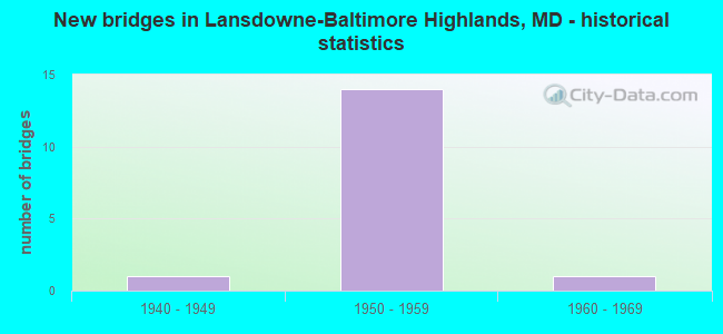
- New bridges - historical statistics
- 11940-1949
- 141950-1959
- 11960-1969


- Bridge Condition - Deck
- 7.7%Very good
- 15.4%Good
- 69.2%Satisfactory
- 7.7%Fair

- Bridge Condition - Superstructure
- 7.7%Very good
- 23.1%Good
- 53.8%Satisfactory
- 7.7%Fair
- 7.7%Poor

- Bridge Condition - Substructure
- 7.7%Good
- 84.6%Satisfactory
- 7.7%Fair
Find on map >> Show street view
Structure Number: 200000B-010001, Location: 50 FT N LANSDOWNE RD (Lat: 39.252761, Lng: -76.663511), Route carried "on" structure: County highway 3200, Year Built: 1961, Status: Open, Structure Length: 6.16m (20.21ft), Average Daily Traffic: 6,410 (year 2017), Truck Traffic: 5%, Average Future Daily Traffic: 7,820 (year 2037), Design Load: HS 20, Features Intersected: CSX RAILROAD, Facility Carried by Structure: HAMMONDS FERRY ROA
Minimum Vertical Clearance: 30+ m (98+ ft), Kilometerpoint: 2.639, Lanes on structure: 2, Owner: County Highway Agency, Approaching Roadway Width: 11.0m (36.1ft), Skew: 4 degrees, Material/Design: Steel, Design/Construction: Stringer/Multi-beam, Number Of Spans In Main Unit: 1, Number Of Approach Spans: 1, Length of Maximum Span: 39.0m (128.0ft), Curb or Sidewalk Widths: Left: 1.5m (4.9ft), Right: 1.5m (4.9ft), Curb-To-Curb Width: 11.0m (36.1ft), Out-to-Out Width: 14.7m (48.2ft)
Condition: Deck: Fair, Superstructure: Poor, Substructure: Fair, Operating Rating: 72.6 metric tons, Method Used To Determine Operating Rating: Load Factor (LF), Inventory Rating: 43.5 metric tons, Method Used To Determine Inventory Rating: Load Factor (LF), Structural Evaluation: Meets minimum limits, Deck Geometry: Meets minimum limits, Underclear: Better than present minimum criteria, Approach Roadway Alignment: Equal to present minimum criteria, Length Of Structure Improvement: 6.16m (20.21ft), Designated Inspection Frequency: Every 24 months, Inspection Date: October 2021, Bridge Improvement Cost: $535,000, Roadway Improvement Cost: $16,000, Total Project Cost: $551,000, Deck Structure Type: Concrete Cast-file-Place, Wearing Surface/Protective System: Wearing Surface: Bituminous
Find on map >> Show street view
Structure Number: 200000B-032202, Location: 0.08 MI W OF HMDS FERY RD (Lat: 39.236614, Lng: -76.664161), Route carried "on" structure: County highway 3245, Year Built: 1955, Status: Posted for load, Structure Length: 0.70m (2.30ft), Average Daily Traffic: 215 (year 2020), Truck Traffic: 5%, Average Future Daily Traffic: 262 (year 2040), Design Load: HS 20, Features Intersected: TRIBUTARY OF PATAPSCO RI, Facility Carried by Structure: RESEARCH AVENUE
Minimum Vertical Clearance: 30+ m (98+ ft), Kilometerpoint: 0.129, Lanes on structure: 2, Owner: County Highway Agency, Approaching Roadway Width: 9.1m (29.9ft), Material/Design: Concrete, Design/Construction: Culvert, Length of Maximum Span: 3.0m (9.8ft), Curb or Sidewalk Widths: Left: 1.2m (3.9ft), Right: 1.2m (3.9ft)
Condition: Channel: Satisfactory, Culverts: Satisfactory, Operating Rating: 24.9 metric tons, Method Used To Determine Operating Rating: Load Factor (LF), Inventory Rating: 15.0 metric tons, Method Used To Determine Inventory Rating: Load Factor (LF), Structural Evaluation: Meets minimum limits, Waterway Adequacy: Better than present minimum criteria, Approach Roadway Alignment: Equal to present desirable criteria, Bridge Posting: Required (Relationship of Operating Rating to Maximum Legal Load: 20.0 - 29.9% below), Designated Inspection Frequency: Every 24 months, Other Special Inspection Frequency: Every 12 months, Inspection Date: July 2021, Other Special Inspection Date: July 2021
Find on map >> Show street view
Structure Number: 300000B-Y021012, Location: Milepost M2.1 (Lat: 39.222200, Lng: -76.691258), Route carried "on" structure: Interstate 895, Year Built: 1957, Status: Open, Structure Length: 7.07m (23.20ft), Average Daily Traffic: 8,846 (year 2019), Truck Traffic: 3%, Average Future Daily Traffic: 11,253 (year 2041), Design Load: HS 20, Features Intersected: HERBERT RUN
Minimum Vertical Clearance: 30+ m (98+ ft), Kilometerpoint: 3.411, Lanes on structure: 2, Base Highway Network: Yes, Toll: On toll road, Owner: State Toll Authority, Approaching Roadway Width: 12.8m (42.0ft), Skew: 1 degrees, Material/Design: Steel, Design/Construction: Stringer/Multi-beam, Number Of Spans In Main Unit: 3, Length of Maximum Span: 24.7m (81.0ft), Curb-To-Curb Width: 12.8m (42.0ft), Out-to-Out Width: 14.1m (46.3ft)
Condition: Deck: Satisfactory, Superstructure: Satisfactory, Substructure: Satisfactory, Operating Rating: 78.9 metric tons, Method Used To Determine Operating Rating: Load Factor (LF), Inventory Rating: 47.2 metric tons, Method Used To Determine Inventory Rating: Load Factor (LF), Structural Evaluation: Equal to present minimum criteria, Deck Geometry: Equal to present desirable criteria, Waterway Adequacy: Superior to present desirable criteria, Approach Roadway Alignment: Equal to present desirable criteria, Designated Inspection Frequency: Every 24 months, Inspection Date: January 2020, Deck Structure Type: Closed Grating, Wearing Surface/Protective System: Wearing Surface: Monolithic Concrete
Find on map >> Show street view
Structure Number: 300000B-Y026011, Location: Milepost M2.5 (Lat: 39.223519, Lng: -76.683978), Route carried "on" structure: Interstate 895, Year Built: 1957, Status: Open, Structure Length: 2.74m (8.99ft), Average Daily Traffic: 7,507 (year 2019), Truck Traffic: 2%, Average Future Daily Traffic: 9,549 (year 2041), Design Load: HS 20, Features Intersected: HALETHORPE FARMS RD
Minimum Vertical Clearance: 30+ m (98+ ft), Kilometerpoint: 4.119, Lanes on structure: 2, Lanes under structure: 1, Base Highway Network: Yes, Toll: On toll road, Owner: State Toll Authority, Approaching Roadway Width: 12.8m (42.0ft), Skew: 1 degrees, Material/Design: Steel, Design/Construction: Stringer/Multi-beam, Number Of Spans In Main Unit: 1, Length of Maximum Span: 25.9m (85.0ft), Curb-To-Curb Width: 12.8m (42.0ft), Out-to-Out Width: 14.1m (46.3ft)
Condition: Deck: Good, Superstructure: Good, Substructure: Satisfactory, Operating Rating: 59.9 metric tons, Method Used To Determine Operating Rating: Load Factor (LF), Inventory Rating: 35.8 metric tons, Method Used To Determine Inventory Rating: Load Factor (LF), Structural Evaluation: Equal to present minimum criteria, Deck Geometry: Equal to present desirable criteria, Underclear: Meets minimum limits, Approach Roadway Alignment: Equal to present desirable criteria, Designated Inspection Frequency: Every 24 months, Inspection Date: December 2021, Deck Structure Type: Closed Grating, Wearing Surface/Protective System: Wearing Surface: Monolithic Concrete
Find on map >> Show street view
Structure Number: 300000B-Y036011, Location: Milepost M3.6 (Lat: 39.231239, Lng: -76.671108), Route carried "on" structure: Interstate 895, Year Built: 1957, Status: Open, Structure Length: 3.32m (10.89ft), Average Daily Traffic: 7,507 (year 2019), Truck Traffic: 2%, Average Future Daily Traffic: 9,549 (year 2041), Design Load: HS 20, Features Intersected: TRANSWAY ROAD
Minimum Vertical Clearance: 30+ m (98+ ft), Kilometerpoint: 5.857, Lanes on structure: 2, Lanes under structure: 2, Base Highway Network: Yes, Toll: On toll road, Owner: State Toll Authority, Approaching Roadway Width: 12.8m (42.0ft), Material/Design: Steel, Design/Construction: Stringer/Multi-beam, Number Of Spans In Main Unit: 3, Length of Maximum Span: 15.9m (52.2ft), Curb-To-Curb Width: 12.8m (42.0ft), Out-to-Out Width: 14.1m (46.3ft)
Condition: Deck: Satisfactory, Superstructure: Satisfactory, Substructure: Satisfactory, Operating Rating: 76.6 metric tons, Method Used To Determine Operating Rating: Load Factor (LF), Inventory Rating: 45.8 metric tons, Method Used To Determine Inventory Rating: Load Factor (LF), Structural Evaluation: Equal to present minimum criteria, Deck Geometry: Equal to present desirable criteria, Underclear: Meets minimum limits, Approach Roadway Alignment: Equal to present desirable criteria, Designated Inspection Frequency: Every 24 months, Inspection Date: December 2021, Deck Structure Type: Closed Grating, Wearing Surface/Protective System: Wearing Surface: Monolithic Concrete
Find on map >> Show street view
Structure Number: 300000B-Y037011, Location: Milepost M3.7 (Lat: 39.232939, Lng: -76.667458), Route carried "on" structure: Interstate 895, Year Built: 1957, Status: Open, Structure Length: 6.34m (20.80ft), Average Daily Traffic: 9,352 (year 2019), Truck Traffic: 6%, Average Future Daily Traffic: 11,896 (year 2041), Design Load: HS 20, Features Intersected: I-695
Minimum Vertical Clearance: 30+ m (98+ ft), Kilometerpoint: 5.889, Lanes on structure: 3, Lanes under structure: 7, Base Highway Network: Yes, Toll: On toll road, Owner: State Toll Authority, Approaching Roadway Width: 15.9m (52.2ft), Skew: 1 degrees, Material/Design: Steel, Design/Construction: Stringer/Multi-beam, Number Of Spans In Main Unit: 4, Length of Maximum Span: 21.6m (70.9ft), Curb-To-Curb Width: 15.9m (52.2ft), Out-to-Out Width: 17.1m (56.1ft)
Condition: Deck: Satisfactory, Superstructure: Satisfactory, Substructure: Satisfactory, Operating Rating: 41.7 metric tons, Method Used To Determine Operating Rating: Load Factor (LF), Inventory Rating: 29.5 metric tons, Method Used To Determine Inventory Rating: Load Factor (LF), Structural Evaluation: Equal to present minimum criteria, Deck Geometry: Somewhat better than minimum adequacy, Underclear: High priority of corrective action, Approach Roadway Alignment: Equal to present desirable criteria, Designated Inspection Frequency: Every 24 months, Inspection Date: January 2020, Deck Structure Type: Concrete Cast-file-Place, Wearing Surface/Protective System: Wearing Surface: Monolithic Concrete
Find on map >> Show street view
Structure Number: 300000B-Y040011, Location: Milepost M4.0 (Lat: 39.233833, Lng: -76.661972), Route carried "on" structure: Interstate 895, Year Built: 1957, Status: Open, Structure Length: 4.57m (14.99ft), Average Daily Traffic: 10,671 (year 2019), Truck Traffic: 6%, Average Future Daily Traffic: 14,178 (year 2041), Design Load: HS 20, Features Intersected: HAMMONDS FERRY RD
Minimum Vertical Clearance: 30+ m (98+ ft), Kilometerpoint: 6.372, Lanes on structure: 2, Lanes under structure: 2, Base Highway Network: Yes, Toll: On toll road, Owner: State Toll Authority, Approaching Roadway Width: 12.8m (42.0ft), Skew: 12 degrees, Material/Design: Steel, Design/Construction: Stringer/Multi-beam, Number Of Spans In Main Unit: 3, Length of Maximum Span: 19.2m (63.0ft), Curb-To-Curb Width: 12.8m (42.0ft), Out-to-Out Width: 14.1m (46.3ft)
Condition: Deck: Satisfactory, Superstructure: Satisfactory, Substructure: Satisfactory, Operating Rating: 58.5 metric tons, Method Used To Determine Operating Rating: Load Factor (LF), Inventory Rating: 34.9 metric tons, Method Used To Determine Inventory Rating: Load Factor (LF), Structural Evaluation: Equal to present minimum criteria, Deck Geometry: Equal to present desirable criteria, Underclear: Equal to present minimum criteria, Approach Roadway Alignment: Equal to present desirable criteria, Designated Inspection Frequency: Every 24 months, Inspection Date: October 2021, Deck Structure Type: Concrete Cast-file-Place, Wearing Surface/Protective System: Wearing Surface: Monolithic Concrete
Find on map >> Show street view
Structure Number: 300000B-Y040012, Location: Milepost M4.0 (Lat: 39.234039, Lng: -76.661833), Route carried "on" structure: Interstate 895, Year Built: 1957, Status: Open, Structure Length: 4.36m (14.30ft), Average Daily Traffic: 10,334 (year 2019), Truck Traffic: 4%, Average Future Daily Traffic: 13,730 (year 2041), Design Load: HS 20, Features Intersected: HAMMONDS FERRY RD
Minimum Vertical Clearance: 30+ m (98+ ft), Kilometerpoint: 6.372, Lanes on structure: 2, Lanes under structure: 2, Base Highway Network: Yes, Toll: On toll road, Owner: State Toll Authority, Approaching Roadway Width: 12.8m (42.0ft), Skew: 11 degrees, Material/Design: Steel, Design/Construction: Stringer/Multi-beam, Number Of Spans In Main Unit: 3, Length of Maximum Span: 17.1m (56.1ft), Curb-To-Curb Width: 12.8m (42.0ft), Out-to-Out Width: 13.9m (45.6ft)
Condition: Deck: Satisfactory, Superstructure: Satisfactory, Substructure: Satisfactory, Operating Rating: 58.5 metric tons, Method Used To Determine Operating Rating: Load Factor (LF), Inventory Rating: 34.9 metric tons, Method Used To Determine Inventory Rating: Load Factor (LF), Structural Evaluation: Equal to present minimum criteria, Deck Geometry: Equal to present desirable criteria, Underclear: Equal to present minimum criteria, Approach Roadway Alignment: Equal to present desirable criteria, Designated Inspection Frequency: Every 24 months, Inspection Date: October 2021, Deck Structure Type: Concrete Cast-file-Place, Wearing Surface/Protective System: Wearing Surface: Monolithic Concrete
Find on map >> Show street view
Structure Number: 300000B-Y046011, Location: Milepost M4.6 (Lat: 39.231861, Lng: -76.649778), Route carried "on" structure: State highway 295, Year Built: 1957, Status: Open, Structure Length: 6.92m (22.70ft), Average Daily Traffic: 48,605 (year 2019), Truck Traffic: 3%, Average Future Daily Traffic: 68,030 (year 2041), Design Load: HS 20, Features Intersected: I-895
Minimum Vertical Clearance: 30+ m (98+ ft), Kilometerpoint: 7.401, Lanes on structure: 3, Lanes under structure: 5, Base Highway Network: Yes, Owner: State Toll Authority, Approaching Roadway Width: 12.8m (42.0ft), Skew: 10 degrees, Material/Design: Steel, Design/Construction: Stringer/Multi-beam, Number Of Spans In Main Unit: 4, Length of Maximum Span: 24.4m (80.1ft), Curb-To-Curb Width: 12.8m (42.0ft), Out-to-Out Width: 14.5m (47.6ft)
Condition: Deck: Satisfactory, Superstructure: Fair, Substructure: Satisfactory, Operating Rating: 79.4 metric tons, Method Used To Determine Operating Rating: Load Factor (LF), Inventory Rating: 47.6 metric tons, Method Used To Determine Inventory Rating: Load Factor (LF), Structural Evaluation: Somewhat better than minimum adequacy, Deck Geometry: Meets minimum limits, Underclear: Meets minimum limits, Approach Roadway Alignment: Equal to present desirable criteria, Designated Inspection Frequency: Every 24 months, Inspection Date: October 2021, Deck Structure Type: Concrete Cast-file-Place, Wearing Surface/Protective System: Wearing Surface: Monolithic Concrete
Find on map >> Show street view
Structure Number: 300000B-Y046012, Location: Milpeost M4.6 (Lat: 39.231944, Lng: -76.650250), Route carried "on" structure: State highway 295, Year Built: 1957, Status: Open, Structure Length: 7.13m (23.39ft), Average Daily Traffic: 53,767 (year 2019), Truck Traffic: 3%, Average Future Daily Traffic: 75,255 (year 2041), Design Load: HS 20, Features Intersected: I-895
Minimum Vertical Clearance: 30+ m (98+ ft), Kilometerpoint: 7.401, Lanes on structure: 4, Lanes under structure: 5, Base Highway Network: Yes, Owner: State Toll Authority, Approaching Roadway Width: 16.5m (54.1ft), Skew: 10 degrees, Material/Design: Steel, Design/Construction: Stringer/Multi-beam, Number Of Spans In Main Unit: 4, Length of Maximum Span: 26.5m (86.9ft), Curb-To-Curb Width: 16.5m (54.1ft), Out-to-Out Width: 18.2m (59.7ft)
Condition: Deck: Satisfactory, Superstructure: Satisfactory, Substructure: Satisfactory, Operating Rating: 78.5 metric tons, Method Used To Determine Operating Rating: Load Factor (LF), Inventory Rating: 47.2 metric tons, Method Used To Determine Inventory Rating: Load Factor (LF), Structural Evaluation: Equal to present minimum criteria, Deck Geometry: Meets minimum limits, Underclear: Meets minimum limits, Approach Roadway Alignment: Equal to present desirable criteria, Designated Inspection Frequency: Every 24 months, Inspection Date: October 2021, Deck Structure Type: Concrete Cast-file-Place, Wearing Surface/Protective System: Wearing Surface: Monolithic Concrete
Find on map >> Show street view
Structure Number: 300000B-Y051011, Location: Milepost M5.1 (Lat: 39.230525, Lng: -76.641906), Route carried "on" structure: Interstate 895, Year Built: 1957, Status: Open, Structure Length: 4.36m (14.30ft), Average Daily Traffic: 18,501 (year 2019), Truck Traffic: 3%, Average Future Daily Traffic: 23,536 (year 2041), Design Load: HS 20, Features Intersected: MD 648
Minimum Vertical Clearance: 30+ m (98+ ft), Kilometerpoint: 8.142, Lanes on structure: 2, Lanes under structure: 2, Base Highway Network: Yes, Toll: On toll road, Owner: State Toll Authority, Approaching Roadway Width: 12.8m (42.0ft), Skew: 1 degrees, Material/Design: Steel, Design/Construction: Stringer/Multi-beam, Number Of Spans In Main Unit: 3, Length of Maximum Span: 19.8m (65.0ft), Curb-To-Curb Width: 12.8m (42.0ft), Out-to-Out Width: 14.1m (46.3ft)
Condition: Deck: Satisfactory, Superstructure: Good, Substructure: Satisfactory, Operating Rating: 88.0 metric tons, Method Used To Determine Operating Rating: Load Factor (LF), Inventory Rating: 52.6 metric tons, Method Used To Determine Inventory Rating: Load Factor (LF), Structural Evaluation: Equal to present minimum criteria, Deck Geometry: Equal to present desirable criteria, Underclear: Meets minimum limits, Approach Roadway Alignment: Equal to present desirable criteria, Designated Inspection Frequency: Every 24 months, Inspection Date: August 2021, Deck Structure Type: Concrete Cast-file-Place, Wearing Surface/Protective System: Wearing Surface: Monolithic Concrete
Find on map >> Show street view
Structure Number: 300000B-Y051012, Location: Milepost M5.1 (Lat: 39.230756, Lng: -76.641939), Route carried "on" structure: Interstate 895, Year Built: 1957, Status: Open, Structure Length: 4.57m (14.99ft), Average Daily Traffic: 18,476 (year 2019), Truck Traffic: 5%, Average Future Daily Traffic: 23,504 (year 2041), Design Load: HS 20, Features Intersected: MD 648
Minimum Vertical Clearance: 30+ m (98+ ft), Kilometerpoint: 8.142, Lanes on structure: 2, Lanes under structure: 2, Base Highway Network: Yes, Toll: On toll road, Owner: State Toll Authority, Approaching Roadway Width: 12.8m (42.0ft), Skew: 17 degrees, Material/Design: Steel, Design/Construction: Stringer/Multi-beam, Number Of Spans In Main Unit: 3, Length of Maximum Span: 19.8m (65.0ft), Curb-To-Curb Width: 12.8m (42.0ft), Out-to-Out Width: 14.1m (46.3ft)
Condition: Deck: Satisfactory, Superstructure: Satisfactory, Substructure: Satisfactory, Operating Rating: 82.5 metric tons, Method Used To Determine Operating Rating: Load Factor (LF), Inventory Rating: 49.4 metric tons, Method Used To Determine Inventory Rating: Load Factor (LF), Structural Evaluation: Equal to present minimum criteria, Deck Geometry: Equal to present desirable criteria, Underclear: Equal to present minimum criteria, Approach Roadway Alignment: Equal to present desirable criteria, Designated Inspection Frequency: Every 24 months, Inspection Date: August 2021, Deck Structure Type: Concrete Cast-file-Place, Wearing Surface/Protective System: Wearing Surface: Monolithic Concrete
Find on map >> Show street view
Structure Number: 300000B-Y05401, Location: Milepost M5.4 (Lat: 39.229536, Lng: -76.636294), Route carried "on" structure: Interstate 895, Year Built: 1957, Status: Open, Structure Length: 5.21m (17.09ft), Average Daily Traffic: 36,977 (year 2019), Truck Traffic: 3%, Average Future Daily Traffic: 47,039 (year 2041), Design Load: HS 20, Features Intersected: B & A RR
Minimum Vertical Clearance: 30+ m (98+ ft), Kilometerpoint: 8.656, Lanes on structure: 4, Base Highway Network: Yes, Toll: On toll road, Owner: State Toll Authority, Approaching Roadway Width: 20.1m (65.9ft), Skew: 32 degrees, Material/Design: Steel, Design/Construction: Stringer/Multi-beam, Number Of Spans In Main Unit: 3, Length of Maximum Span: 14.0m (45.9ft), Curb-To-Curb Width: 20.1m (65.9ft), Out-to-Out Width: 23.6m (77.4ft)
Condition: Deck: Good, Superstructure: Good, Substructure: Satisfactory, Operating Rating: 83.4 metric tons, Method Used To Determine Operating Rating: Load Factor (LF), Inventory Rating: 49.9 metric tons, Method Used To Determine Inventory Rating: Load Factor (LF), Structural Evaluation: Equal to present minimum criteria, Deck Geometry: Equal to present minimum criteria, Underclear: Equal to present minimum criteria, Approach Roadway Alignment: Equal to present desirable criteria, Designated Inspection Frequency: Every 24 months, Inspection Date: November 2021, Deck Structure Type: Closed Grating, Wearing Surface/Protective System: Wearing Surface: Monolithic Concrete
Find on map >> Show street view
Structure Number: 300000B-Y05901, Location: Milepost M5.9 (Lat: 39.229128, Lng: -76.633778), Route carried "on" structure: Interstate 895, Year Built: 1957, Year Reconstructed: 2019, Status: Open, Structure Length: 72.69m (238.48ft), Average Daily Traffic: 36,977 (year 2019), Truck Traffic: 3%, Average Future Daily Traffic: 47,039 (year 2041), Design Load: HS 20, Features Intersected: PATAPSCO RIVER FLATS
Minimum Vertical Clearance: 30+ m (98+ ft), Kilometerpoint: 9.493, Lanes on structure: 4, Base Highway Network: Yes, Toll: On toll road, Owner: State Toll Authority, Approaching Roadway Width: 21.9m (71.9ft), Skew: 30 degrees, Material/Design: Steel, Design/Construction: Stringer/Multi-beam, Number Of Spans In Main Unit: 42, Length of Maximum Span: 21.0m (68.9ft), Curb-To-Curb Width: 15.9m (52.2ft), Out-to-Out Width: 20.0m (65.6ft)
Condition: Deck: Very good, Superstructure: Very good, Substructure: Good, Channel: Satisfactory, Operating Rating: 85.7 metric tons, Method Used To Determine Operating Rating: Load Factor (LF), Inventory Rating: 51.2 metric tons, Method Used To Determine Inventory Rating: Load Factor (LF), Structural Evaluation: Better than present minimum criteria, Deck Geometry: Meets minimum limits, Waterway Adequacy: Better than present minimum criteria, Approach Roadway Alignment: Equal to present desirable criteria, Designated Inspection Frequency: Every 24 months, Critical Feature Inspection Frequency: Every 24 months, Underwater Inspection Frequency: Every 48 months, Inspection Date: Febuary 2020, Critical Feature Inspection Date: Febuary 2020, Underwater Inspection Date: March 2020, Deck Structure Type: Closed Grating, Wearing Surface/Protective System: Wearing Surface: Latex Concrete, Deck Protection: Galvanized Reinforcing
Find on map >> Show street view
Structure Number: 10000003001801, Location: 0.31 MI S OF BALT CITY (Lat: 39.244942, Lng: -76.647664), Route carried "under" structure: County highway 3281, Year Built: 1949, Structure Length: 0. m, Average Daily Traffic: 6,867 (year 2005), Features Intersected: DAISY AVENUE, Facility Carried by Structure: MD 295
Minimum Vertical Clearance: 4.88m (16.01ft), Kilometerpoint: 0.595, Lanes on structure: 6, Lanes under structure: 2, Material/Design: Steel, Design/Construction: Stringer/Multi-beam, Length of Maximum Span: 16.5m (54.1ft)
Find on map >> Show street view
Structure Number: 10000003011001, Location: 0.44 M N OF AA CO LINE (Lat: 39.236597, Lng: -76.667425), Route carried "under" structure: Interstate 695, Year Built: 1957, Structure Length: 0. m, Average Daily Traffic: 127,679 (year 2009), Features Intersected: IS 695, Facility Carried by Structure: HOLLINS FERRY ROAD
Minimum Vertical Clearance: 4.88m (16.01ft), Kilometerpoint: 0.708, Lanes on structure: 4, Lanes under structure: 8, Material/Design: Steel, Design/Construction: Stringer/Multi-beam, Length of Maximum Span: 21.9m (71.9ft)