Bridge Statistics for Lansing, Illinois (IL)
Condition, Traffic, Stress, Structural Evaluation, Project Costs
- National Bridge Inventory (NBI) Statistics
- 24Number of bridges
- 489ft / 149mTotal length
- $1,637,000Total costs
- 1,228,550Total average daily traffic
- 280,917Total average daily truck traffic
- National Bridge Inventory (NBI) Registered Bridges for Lansing
- No street view available for this location
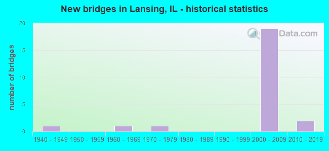
- New bridges - historical statistics
- 11940-1949
- 11960-1969
- 11970-1979
- 192000-2009
- 22010-2019
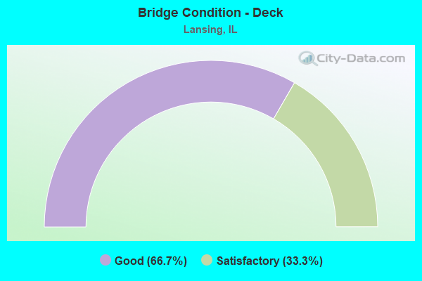
- Bridge Condition - Deck
- 66.7%Good
- 33.3%Satisfactory
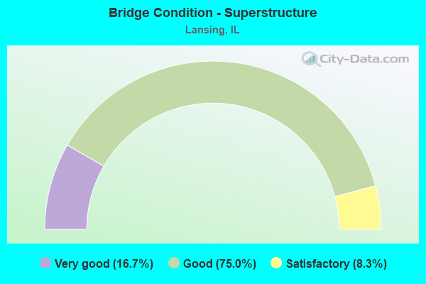
- Bridge Condition - Superstructure
- 16.7%Very good
- 75.0%Good
- 8.3%Satisfactory
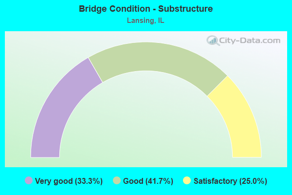
- Bridge Condition - Substructure
- 33.3%Very good
- 41.7%Good
- 25.0%Satisfactory
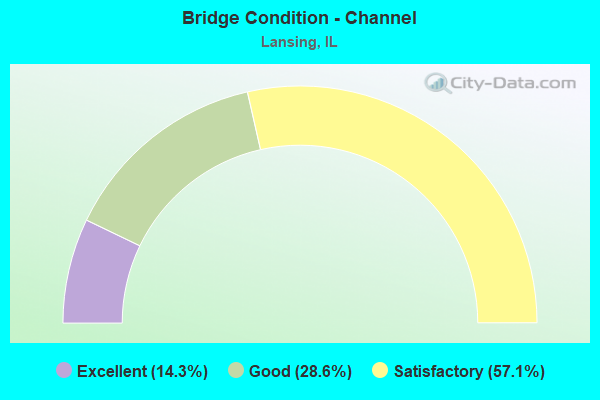
- Bridge Condition - Channel
- 14.3%Excellent
- 28.6%Good
- 57.1%Satisfactory
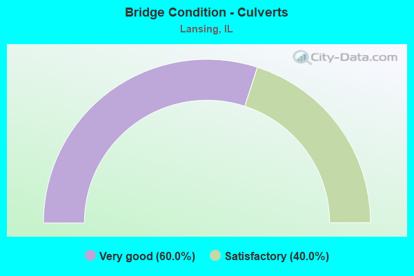
- Bridge Condition - Culverts
- 60.0%Very good
- 40.0%Satisfactory
Find on map >> Show street view
Structure Number: 160807, Location: 0.01 M N OF 170TH ST (Lat: 41.586700, Lng: -87.539447), Route carried "on" structure: Other road , Year Built: 1941, Year Reconstructed: 2000, Status: Open, Structure Length: 4.91m (16.11ft), Average Daily Traffic: 12,600 (year 2018), Truck Traffic: 3%, Average Future Daily Traffic: 12,669 (year 2032), Features Intersected: CALUMET RIVER, Facility Carried by Structure: BURNHAM AVE
Minimum Vertical Clearance: 30+ m (98+ ft), Kilometerpoint: 12.987, Lanes on structure: 4, Base Highway Network: Yes, Owner: State Highway Agency, Approaching Roadway Width: 13.5m (44.3ft), Material/Design: Steel continuous, Design/Construction: Stringer/Multi-beam, Number Of Spans In Main Unit: 3, Length of Maximum Span: 16.1m (52.8ft), Curb or Sidewalk Widths: Left: 2.3m (7.5ft), Right: 2.3m (7.5ft), Curb-To-Curb Width: 15.8m (51.8ft), Out-to-Out Width: 20.9m (68.6ft)
Condition: Deck: Good, Superstructure: Good, Substructure: Good, Channel: Satisfactory, Operating Rating: 89.1 metric tons, Method Used To Determine Operating Rating: Load Factor (LF) rating reported by rating factor (RF) method using MS18 loading, Inventory Rating: 58.0 metric tons, Method Used To Determine Inventory Rating: Load Factor (LF) rating reported by rating factor (RF) method using MS18 loading, Structural Evaluation: Better than present minimum criteria, Deck Geometry: Meets minimum limits, Waterway Adequacy: Better than present minimum criteria, Approach Roadway Alignment: Equal to present desirable criteria, Length Of Structure Improvement: 5.82m (19.09ft), Designated Inspection Frequency: Every 48 months, Other Special Inspection Frequency: Every 24 months, Inspection Date: June 2019, Other Special Inspection Date: March 2021, Bridge Improvement Cost: $1,091,000, Roadway Improvement Cost: $109,000, Total Project Cost: $1,637,000, Deck Structure Type: Concrete Cast-file-Place, Wearing Surface/Protective System: Deck Protection: Epoxy Coated Reinforcing
Find on map >> Show street view
Structure Number: 162787, Location: 0.8 M S Rivr Oaks Dr (Lat: 41.585047, Lng: -87.529794), Route carried "on" structure: Other road , Year Built: 2004, Status: Open, Structure Length: 6.00m (19.69ft), Average Daily Traffic: 8,700 (year 2018), Truck Traffic: 2%, Average Future Daily Traffic: 8,549 (year 2032), Design Load: HS 20, Features Intersected: LITTLE CALUMET RIVER, Facility Carried by Structure: WENTWORTH AVE
Minimum Vertical Clearance: 30+ m (98+ ft), Kilometerpoint: 4.232, Lanes on structure: 4, Owner: State Highway Agency, Approaching Roadway Width: 16.5m (54.1ft), Material/Design: Steel continuous, Design/Construction: Stringer/Multi-beam, Number Of Spans In Main Unit: 3, Length of Maximum Span: 24.5m (80.4ft), Curb or Sidewalk Widths: Left: 2.1m (6.9ft), Right: 2.1m (6.9ft), Curb-To-Curb Width: 16.5m (54.1ft), Out-to-Out Width: 21.3m (69.9ft)
Condition: Deck: Good, Superstructure: Good, Substructure: Very good, Channel: Satisfactory, Operating Rating: 83.3 metric tons, Method Used To Determine Operating Rating: Load Factor (LF) rating reported by rating factor (RF) method using MS18 loading, Inventory Rating: 49.9 metric tons, Method Used To Determine Inventory Rating: Load Factor (LF) rating reported by rating factor (RF) method using MS18 loading, Structural Evaluation: Better than present minimum criteria, Deck Geometry: Meets minimum limits, Waterway Adequacy: Equal to present desirable criteria, Approach Roadway Alignment: Equal to present desirable criteria, Designated Inspection Frequency: Every 48 months, Inspection Date: January 2020, Deck Structure Type: Concrete Cast-file-Place, Wearing Surface/Protective System: Deck Protection: Epoxy Coated Reinforcing
Find on map >> Show street view
Structure Number: 16279, Location: 2.8 M E OF IL 394 (Lat: 41.577561, Lng: -87.529719), Route carried "on" structure: Other road , Year Built: 2004, Status: Open, Structure Length: 5.50m (18.04ft), Average Daily Traffic: 8,700 (year 2018), Truck Traffic: 2%, Average Future Daily Traffic: 8,549 (year 2032), Design Load: HS 20, Features Intersected: I- 80,94, Facility Carried by Structure: WENTWORTH AVE
Minimum Vertical Clearance: 30+ m (98+ ft), Kilometerpoint: 5.069, Lanes on structure: 4, Lanes under structure: 10, Owner: State Highway Agency, Approaching Roadway Width: 20.0m (65.6ft), Material/Design: Steel continuous, Design/Construction: Stringer/Multi-beam, Number Of Spans In Main Unit: 2, Length of Maximum Span: 26.3m (86.3ft), Curb or Sidewalk Widths: Left: 2.1m (6.9ft), Right: 2.1m (6.9ft), Curb-To-Curb Width: 20.0m (65.6ft), Out-to-Out Width: 24.9m (81.7ft)
Condition: Deck: Good, Superstructure: Good, Substructure: Good, Operating Rating: 89.1 metric tons, Method Used To Determine Operating Rating: Load Factor (LF) rating reported by rating factor (RF) method using MS18 loading, Inventory Rating: 68.7 metric tons, Method Used To Determine Inventory Rating: Load Factor (LF) rating reported by rating factor (RF) method using MS18 loading, Structural Evaluation: Better than present minimum criteria, Deck Geometry: Better than present minimum criteria, Underclear: High priority of corrective action, Approach Roadway Alignment: Equal to present desirable criteria, Designated Inspection Frequency: Every 24 months, Inspection Date: May 2020, Deck Structure Type: Concrete Cast-file-Place, Wearing Surface/Protective System: Deck Protection: Epoxy Coated Reinforcing
Find on map >> Show street view
Structure Number: 162791, Location: 2.3 M E IL 394 (Lat: 41.577647, Lng: -87.539742), Route carried "on" structure: Interstate 80, Year Built: 2004, Year Reconstructed: 2006, Status: Open, Structure Length: 6.62m (21.72ft), Average Daily Traffic: 185,600 (year 2021), Truck Traffic: 26%, Average Future Daily Traffic: 139,668 (year 2032), Design Load: HS 20, Features Intersected: BURNHAM AVE
Minimum Vertical Clearance: 30+ m (98+ ft), Kilometerpoint: 261.849, Lanes on structure: 11, Lanes under structure: 2, Base Highway Network: Yes, Owner: State Highway Agency, Approaching Roadway Width: 56.7m (186.0ft), Skew: 30 degrees, Material/Design: Steel continuous, Design/Construction: Stringer/Multi-beam, Number Of Spans In Main Unit: 3, Length of Maximum Span: 33.5m (109.9ft), Curb-To-Curb Width: 56.7m (186.0ft), Out-to-Out Width: 59.6m (195.5ft)
Condition: Deck: Good, Superstructure: Good, Substructure: Good, Operating Rating: 84.9 metric tons, Method Used To Determine Operating Rating: Load Factor (LF) rating reported by rating factor (RF) method using MS18 loading, Inventory Rating: 50.9 metric tons, Method Used To Determine Inventory Rating: Load Factor (LF) rating reported by rating factor (RF) method using MS18 loading, Structural Evaluation: Better than present minimum criteria, Deck Geometry: Superior to present desirable criteria, Underclear: Better than present minimum criteria, Approach Roadway Alignment: Equal to present desirable criteria, Designated Inspection Frequency: Every 24 months, Inspection Date: October 2020, Deck Structure Type: Concrete Cast-file-Place, Wearing Surface/Protective System: Deck Protection: Epoxy Coated Reinforcing
Find on map >> Show street view
Structure Number: 162792, Location: 1.8 M E IL 394 (Lat: 41.577611, Lng: -87.547253), Route carried "on" structure: Interstate 80, Year Built: 2004, Year Reconstructed: 2005, Status: Open, Structure Length: 5.50m (18.04ft), Average Daily Traffic: 218,400 (year 2021), Truck Traffic: 22%, Average Future Daily Traffic: 159,032 (year 2032), Features Intersected: BIKEWAY AVE (RR AVE)
Minimum Vertical Clearance: 30+ m (98+ ft), Kilometerpoint: 261.141, Lanes on structure: 16, Lanes under structure: 2, Base Highway Network: Yes, Owner: State Highway Agency, Approaching Roadway Width: 70.7m (232.0ft), Skew: 30 degrees, Material/Design: Prestressed concrete continuous, Design/Construction: Stringer/Multi-beam, Number Of Spans In Main Unit: 3, Length of Maximum Span: 27.5m (90.2ft), Curb-To-Curb Width: 70.7m (232.0ft), Out-to-Out Width: 73.7m (241.8ft)
Condition: Deck: Satisfactory, Superstructure: Good, Substructure: Satisfactory, Operating Rating: 89.1 metric tons, Method Used To Determine Operating Rating: Load Factor (LF) rating reported by rating factor (RF) method using MS18 loading, Inventory Rating: 48.3 metric tons, Method Used To Determine Inventory Rating: Load Factor (LF) rating reported by rating factor (RF) method using MS18 loading, Structural Evaluation: Equal to present minimum criteria, Deck Geometry: Superior to present desirable criteria, Underclear: Meets minimum limits, Approach Roadway Alignment: Equal to present desirable criteria, Designated Inspection Frequency: Every 24 months, Inspection Date: January 2022, Deck Structure Type: Concrete Cast-file-Place, Wearing Surface/Protective System: Deck Protection: Epoxy Coated Reinforcing
Find on map >> Show street view
Structure Number: 162793, Location: 1.2 M E IL 394 (Lat: 41.578592, Lng: -87.558894), Route carried "on" structure: US 6, Year Built: 2005, Status: Open, Structure Length: 16.34m (53.61ft), Average Daily Traffic: 22,200 (year 2021), Truck Traffic: 3%, Average Future Daily Traffic: 26,677 (year 2032), Design Load: HS 20, Features Intersected: I- 80,94 KINGERY, Facility Carried by Structure: IL 83 (TORRENCE)
Minimum Vertical Clearance: 30+ m (98+ ft), Kilometerpoint: 287.099, Lanes on structure: 6, Lanes under structure: 6, Base Highway Network: Yes, Owner: State Highway Agency, Approaching Roadway Width: 33.2m (108.9ft), Skew: 30 degrees, Material/Design: Steel continuous, Design/Construction: Stringer/Multi-beam, Number Of Spans In Main Unit: 7, Number Of Approach Spans: 24, Length of Maximum Span: 30.5m (100.1ft), Curb or Sidewalk Widths: Left: 3.9m (12.8ft), Right: 3.9m (12.8ft), Curb-To-Curb Width: 33.2m (108.9ft), Out-to-Out Width: 49.8m (163.4ft)
Condition: Deck: Good, Superstructure: Satisfactory, Substructure: Satisfactory, Operating Rating: 82.0 metric tons, Method Used To Determine Operating Rating: Load Factor (LF) rating reported by rating factor (RF) method using MS18 loading, Inventory Rating: 49.2 metric tons, Method Used To Determine Inventory Rating: Load Factor (LF) rating reported by rating factor (RF) method using MS18 loading, Structural Evaluation: Equal to present minimum criteria, Deck Geometry: Superior to present desirable criteria, Underclear: High priority of corrective action, Approach Roadway Alignment: Equal to present desirable criteria, Designated Inspection Frequency: Every 24 months, Critical Feature Inspection Frequency: Every 24 months, Inspection Date: August 2020, Critical Feature Inspection Date: August 2020, Deck Structure Type: Concrete Cast-file-Place, Wearing Surface/Protective System: Deck Protection: Epoxy Coated Reinforcing
Find on map >> Show street view
Structure Number: 162794, Location: 0.9 M W OF IL-83 (Lat: 41.577656, Lng: -87.575742), Route carried "on" structure: Interstate 94, Year Built: 2004, Status: Open, Structure Length: 14.37m (47.15ft), Average Daily Traffic: 31,750 (year 2021), Truck Traffic: 26%, Average Future Daily Traffic: 46,556 (year 2032), Design Load: HS 20, Features Intersected: I- 80 WB
Minimum Vertical Clearance: 30+ m (98+ ft), Kilometerpoint: 120.295, Lanes on structure: 2, Lanes under structure: 2, Base Highway Network: Yes, Owner: State Highway Agency, Approaching Roadway Width: 16.8m (55.1ft), Skew: 6 degrees, Material/Design: Steel continuous, Design/Construction: Stringer/Multi-beam, Number Of Spans In Main Unit: 2, Length of Maximum Span: 69.5m (228.0ft), Curb-To-Curb Width: 16.8m (55.1ft), Out-to-Out Width: 17.8m (58.4ft)
Condition: Deck: Satisfactory, Superstructure: Good, Substructure: Good, Operating Rating: 89.1 metric tons, Method Used To Determine Operating Rating: Load Factor (LF) rating reported by rating factor (RF) method using MS18 loading, Inventory Rating: 57.7 metric tons, Method Used To Determine Inventory Rating: Load Factor (LF) rating reported by rating factor (RF) method using MS18 loading, Structural Evaluation: Better than present minimum criteria, Deck Geometry: Superior to present desirable criteria, Underclear: High priority of corrective action, Approach Roadway Alignment: Equal to present desirable criteria, Designated Inspection Frequency: Every 24 months, Inspection Date: April 2020, Deck Structure Type: Concrete Cast-file-Place, Wearing Surface/Protective System: Deck Protection: Epoxy Coated Reinforcing
Find on map >> Show street view
Structure Number: 162796, Location: 1.6 M S OF US 6 (Lat: 41.577525, Lng: -87.582000), Route carried "on" structure: State highway 394, Year Built: 2006, Status: Open, Structure Length: 8.14m (26.71ft), Average Daily Traffic: 47,300 (year 2020), Truck Traffic: 14%, Average Future Daily Traffic: 31,621 (year 2032), Design Load: HS 20, Features Intersected: I- 80 KINGERY
Minimum Vertical Clearance: 30+ m (98+ ft), Kilometerpoint: 22.981, Lanes on structure: 2, Lanes under structure: 8, Base Highway Network: Yes, Owner: State Highway Agency, Approaching Roadway Width: 7.3m (24.0ft), Material/Design: Steel continuous, Design/Construction: Stringer/Multi-beam, Number Of Spans In Main Unit: 2, Length of Maximum Span: 40.0m (131.2ft), Curb-To-Curb Width: 14.4m (47.2ft), Out-to-Out Width: 15.4m (50.5ft)
Condition: Deck: Good, Superstructure: Good, Substructure: Satisfactory, Operating Rating: 84.6 metric tons, Method Used To Determine Operating Rating: Load Factor (LF) rating reported by rating factor (RF) method using MS18 loading, Inventory Rating: 50.5 metric tons, Method Used To Determine Inventory Rating: Load Factor (LF) rating reported by rating factor (RF) method using MS18 loading, Structural Evaluation: Equal to present minimum criteria, Deck Geometry: Superior to present desirable criteria, Approach Roadway Alignment: Equal to present desirable criteria, Designated Inspection Frequency: Every 24 months, Inspection Date: August 2020, Deck Structure Type: Concrete Cast-file-Place, Wearing Surface/Protective System: Deck Protection: Epoxy Coated Reinforcing
Find on map >> Show street view
Structure Number: 162797, Location: I80/294 & Ill 394 (Lat: 41.574544, Lng: -87.583014), Route carried "on" structure: State highway 394, Year Built: 2006, Status: Open, Structure Length: 7.52m (24.67ft), Average Daily Traffic: 47,300 (year 2020), Truck Traffic: 14%, Average Future Daily Traffic: 63,242 (year 2032), Design Load: HS 20, Features Intersected: RR - CN
Minimum Vertical Clearance: 30+ m (98+ ft), Kilometerpoint: 22.627, Lanes on structure: 4, Base Highway Network: Yes, Owner: State Highway Agency, Approaching Roadway Width: 26.4m (86.6ft), Skew: 32 degrees, Material/Design: Prestressed concrete continuous, Design/Construction: Stringer/Multi-beam, Number Of Spans In Main Unit: 3, Length of Maximum Span: 29.0m (95.1ft), Curb-To-Curb Width: 26.4m (86.6ft), Out-to-Out Width: 28.4m (93.2ft)
Condition: Deck: Satisfactory, Superstructure: Very good, Substructure: Very good, Operating Rating: 64.2 metric tons, Method Used To Determine Operating Rating: Load Factor (LF) rating reported by rating factor (RF) method using MS18 loading, Inventory Rating: 40.2 metric tons, Method Used To Determine Inventory Rating: Load Factor (LF) rating reported by rating factor (RF) method using MS18 loading, Structural Evaluation: Equal to present desirable criteria, Deck Geometry: Superior to present desirable criteria, Underclear: Superior to present desirable criteria, Approach Roadway Alignment: Equal to present desirable criteria, Designated Inspection Frequency: Every 24 months, Inspection Date: May 2021, Deck Structure Type: Concrete Cast-file-Place, Wearing Surface/Protective System: Deck Protection: Epoxy Coated Reinforcing
Find on map >> Show street view
Structure Number: 162798, Location: .2 MI S. I-80 (Lat: 41.574025, Lng: -87.583225), Route carried "on" structure: State highway 394, Year Built: 2006, Year Reconstructed: 2007, Status: Open, Structure Length: 7.52m (24.67ft), Average Daily Traffic: 36,300 (year 2020), Truck Traffic: 19%, Average Future Daily Traffic: 31,621 (year 2032), Design Load: HS 20, Features Intersected: RR - CN
Minimum Vertical Clearance: 30+ m (98+ ft), Kilometerpoint: 22.595, Lanes on structure: 2, Base Highway Network: Yes, Owner: State Highway Agency, Approaching Roadway Width: 24.1m (79.1ft), Skew: 2 degrees, Material/Design: Prestressed concrete continuous, Design/Construction: Stringer/Multi-beam, Number Of Spans In Main Unit: 3, Length of Maximum Span: 29.0m (95.1ft), Curb-To-Curb Width: 24.1m (79.1ft), Out-to-Out Width: 25.6m (84.0ft)
Condition: Deck: Satisfactory, Superstructure: Very good, Substructure: Very good, Operating Rating: 63.5 metric tons, Method Used To Determine Operating Rating: Load Factor (LF) rating reported by rating factor (RF) method using MS18 loading, Inventory Rating: 39.9 metric tons, Method Used To Determine Inventory Rating: Load Factor (LF) rating reported by rating factor (RF) method using MS18 loading, Structural Evaluation: Equal to present desirable criteria, Deck Geometry: Superior to present desirable criteria, Underclear: Superior to present desirable criteria, Approach Roadway Alignment: Equal to present desirable criteria, Designated Inspection Frequency: Every 24 months, Inspection Date: May 2021, Deck Structure Type: Concrete Cast-file-Place, Wearing Surface/Protective System: Deck Protection: Epoxy Coated Reinforcing
Find on map >> Show street view
Structure Number: 162799, Location: .5 MI S. I80/294 (Lat: 41.570500, Lng: -87.583744), Route carried "on" structure: Other road , Year Built: 2005, Status: Open, Structure Length: 7.08m (23.23ft), Average Daily Traffic: 8,900 (year 2018), Truck Traffic: 4%, Average Future Daily Traffic: 7,416 (year 2032), Design Load: HS 20, Features Intersected: IL 394, Facility Carried by Structure: THORNTON-LANSING R
Minimum Vertical Clearance: 30+ m (98+ ft), Kilometerpoint: 7.451, Lanes on structure: 2, Lanes under structure: 4, Owner: State Highway Agency, Approaching Roadway Width: 9.8m (32.2ft), Material/Design: Steel continuous, Design/Construction: Stringer/Multi-beam, Number Of Spans In Main Unit: 2, Length of Maximum Span: 35.0m (114.8ft), Curb-To-Curb Width: 9.8m (32.2ft), Out-to-Out Width: 10.8m (35.4ft)
Condition: Deck: Good, Superstructure: Good, Substructure: Good, Operating Rating: 89.1 metric tons, Method Used To Determine Operating Rating: Load Factor (LF) rating reported by rating factor (RF) method using MS18 loading, Inventory Rating: 55.1 metric tons, Method Used To Determine Inventory Rating: Load Factor (LF) rating reported by rating factor (RF) method using MS18 loading, Structural Evaluation: Better than present minimum criteria, Deck Geometry: Meets minimum limits, Underclear: High priority of corrective action, Approach Roadway Alignment: Equal to present desirable criteria, Designated Inspection Frequency: Every 24 months, Inspection Date: June 2020, Deck Structure Type: Concrete Cast-file-Place, Wearing Surface/Protective System: Deck Protection: Epoxy Coated Reinforcing
Find on map >> Show street view
Structure Number: 162804, Location: RAMP WB TO SB (Lat: 41.579181, Lng: -87.578925), Route carried "on" structure: Other road , Year Built: 2006, Status: Open, Structure Length: 55.53m (182.19ft), Average Daily Traffic: 7,300 (year 2021), Average Future Daily Traffic: 96,923 (year 2032), Design Load: HS 20, Features Intersected: I- 80,94, Facility Carried by Structure: I- 94 WB TO IL 394
Minimum Vertical Clearance: 30+ m (98+ ft), Kilometerpoint: 0.241, Lanes on structure: 1, Lanes under structure: 8, Base Highway Network: Yes (Inventory Route: 10094044, Subroute: 80), Owner: State Highway Agency, Approaching Roadway Width: 9.1m (29.9ft), Material/Design: Steel continuous, Design/Construction: Stringer/Multi-beam, Number Of Spans In Main Unit: 9, Length of Maximum Span: 73.4m (240.8ft), Curb-To-Curb Width: 9.1m (29.9ft), Out-to-Out Width: 10.1m (33.1ft)
Condition: Deck: Good, Superstructure: Good, Substructure: Very good, Operating Rating: 44.1 metric tons, Method Used To Determine Operating Rating: Load Factor (LF) rating reported by rating factor (RF) method using MS18 loading, Inventory Rating: 32.4 metric tons, Method Used To Determine Inventory Rating: Load Factor (LF) rating reported by rating factor (RF) method using MS18 loading, Structural Evaluation: Better than present minimum criteria, Deck Geometry: Meets minimum limits, Underclear: High priority of corrective action, Approach Roadway Alignment: Equal to present minimum criteria, Designated Inspection Frequency: Every 24 months, Inspection Date: April 2021, Deck Structure Type: Concrete Cast-file-Place, Wearing Surface/Protective System: Deck Protection: Epoxy Coated Reinforcing
Find on map >> Show street view
Structure Number: 163007, Location: 0.16 MI N.Glenwood L (Lat: 41.545081, Lng: -87.539386), Route carried "on" structure: City street , Year Built: 2010, Status: Open, Structure Length: 0.73m (2.40ft), Average Daily Traffic: 250 (year 2018), Truck Traffic: 9%, Average Future Daily Traffic: 30 (year 2032), Design Load: HS 20+Mod, Features Intersected: LANSING DITCH, Facility Carried by Structure: FIRE STA. 3 Dr.
Minimum Vertical Clearance: 30+ m (98+ ft), Kilometerpoint: 0.016, Lanes on structure: 2, Owner: City or Municipal Highway Agency, Approaching Roadway Width: 11.1m (36.4ft), Material/Design: Concrete, Design/Construction: Culvert, Number Of Spans In Main Unit: 2, Length of Maximum Span: 3.0m (9.8ft), Curb or Sidewalk Widths: Left: 2.1m (6.9ft), Right: 0.0m, Curb-To-Curb Width: 11.1m (36.4ft), Out-to-Out Width: 19.5m (64.0ft)
Condition: Channel: Good, Culverts: Very good, Operating Rating: 54.1 metric tons, Method Used To Determine Operating Rating: Field evaluation and documented engineering judgment, Inventory Rating: 32.4 metric tons, Method Used To Determine Inventory Rating: Field evaluation and documented engineering judgment, Structural Evaluation: Equal to present desirable criteria, Deck Geometry: Superior to present desirable criteria, Waterway Adequacy: Better than present minimum criteria, Approach Roadway Alignment: Equal to present desirable criteria, Designated Inspection Frequency: Every 48 months, Inspection Date: October 2021, Wearing Surface/Protective System: Wearing Surface: Bituminous
Find on map >> Show street view
Structure Number: 163277, Location: 1M E TORRENCE AV (Lat: 41.542814, Lng: -87.540933), Route carried "on" structure: Other road , Year Built: 2002, Status: Open, Structure Length: 1.12m (3.67ft), Average Daily Traffic: 13,500 (year 2018), Truck Traffic: 4%, Average Future Daily Traffic: 12,772 (year 2032), Design Load: HS 20, Features Intersected: LANSING DRAIN DITCH, Facility Carried by Structure: GLENWOOD-LANSING R
Minimum Vertical Clearance: 30+ m (98+ ft), Kilometerpoint: 5.472, Lanes on structure: 5, Base Highway Network: Yes, Owner: County Highway Agency, Approaching Roadway Width: 18.3m (60.0ft), Skew: 5 degrees, Material/Design: Concrete, Design/Construction: Culvert, Number Of Spans In Main Unit: 2, Length of Maximum Span: 4.8m (15.7ft)
Condition: Channel: Excellent, Culverts: Very good, Operating Rating: 54.1 metric tons, Method Used To Determine Operating Rating: Field evaluation and documented engineering judgment, Inventory Rating: 32.4 metric tons, Method Used To Determine Inventory Rating: Field evaluation and documented engineering judgment, Structural Evaluation: Equal to present desirable criteria, Waterway Adequacy: Equal to present desirable criteria, Approach Roadway Alignment: Equal to present desirable criteria, Designated Inspection Frequency: Every 48 months, Inspection Date: July 2020, Deck Structure Type: Other
Find on map >> Show street view
Structure Number: 164005, Location: 0.2 M S 186TH P2 (Lat: 41.554742, Lng: -87.546617), Route carried "on" structure: City street , Year Built: 1964, Status: Open, Structure Length: 1.01m (3.31ft), Average Daily Traffic: 950 (year 2018), Truck Traffic: 4%, Average Future Daily Traffic: 112 (year 2032), Features Intersected: NORTH CR, Facility Carried by Structure: OAKWOOD
Minimum Vertical Clearance: 30+ m (98+ ft), Kilometerpoint: 0.016, Lanes on structure: 2, Owner: City or Municipal Highway Agency, Approaching Roadway Width: 4.3m (14.1ft), Material/Design: Concrete, Design/Construction: Culvert, Number Of Spans In Main Unit: 3, Length of Maximum Span: 3.0m (9.8ft), Curb or Sidewalk Widths: Left: 0.9m (3.0ft), Right: 0.9m (3.0ft), Curb-To-Curb Width: 9.9m (32.5ft), Out-to-Out Width: 12.3m (40.4ft)
Condition: Channel: Satisfactory, Culverts: Satisfactory, Operating Rating: 40.5 metric tons, Method Used To Determine Operating Rating: Field evaluation and documented engineering judgment, Inventory Rating: 24.3 metric tons, Method Used To Determine Inventory Rating: Field evaluation and documented engineering judgment, Structural Evaluation: Equal to present minimum criteria, Deck Geometry: Equal to present minimum criteria, Waterway Adequacy: Better than present minimum criteria, Approach Roadway Alignment: Equal to present desirable criteria, Designated Inspection Frequency: Every 24 months, Inspection Date: June 2020, Wearing Surface/Protective System: Wearing Surface: Bituminous
Find on map >> Show street view
Structure Number: 16712, Location: 50FT W BURNHAM AVE (Lat: 41.551772, Lng: -87.539456), Route carried "on" structure: City street , Year Built: 1970, Status: Posted for load, Structure Length: 0.69m (2.26ft), Average Daily Traffic: 850 (year 2018), Truck Traffic: 7%, Average Future Daily Traffic: 515 (year 2032), Design Load: H 15, Features Intersected: LANSING DRN DITCH, Facility Carried by Structure: 189TH STREET
Minimum Vertical Clearance: 30+ m (98+ ft), Kilometerpoint: 0.048, Lanes on structure: 2, Owner: City or Municipal Highway Agency, Approaching Roadway Width: 9.8m (32.2ft), Material/Design: Concrete, Design/Construction: Culvert, Number Of Spans In Main Unit: 2, Length of Maximum Span: 3.0m (9.8ft), Curb or Sidewalk Widths: Left: 1.5m (4.9ft), Right: 1.5m (4.9ft), Curb-To-Curb Width: 9.8m (32.2ft), Out-to-Out Width: 19.8m (65.0ft)
Condition: Channel: Satisfactory, Culverts: Satisfactory, Operating Rating: 23.7 metric tons, Method Used To Determine Operating Rating: Load Factor (LF) rating reported by rating factor (RF) method using MS18 loading, Inventory Rating: 14.3 metric tons, Method Used To Determine Inventory Rating: Load Factor (LF) rating reported by rating factor (RF) method using MS18 loading, Structural Evaluation: Meets minimum limits, Deck Geometry: Equal to present minimum criteria, Waterway Adequacy: Better than present minimum criteria, Approach Roadway Alignment: Equal to present desirable criteria, Bridge Posting: Required (Relationship of Operating Rating to Maximum Legal Load: > 39.9% below), Designated Inspection Frequency: Every 24 months, Inspection Date: September 2021, Wearing Surface/Protective System: Wearing Surface: Bituminous
Find on map >> Show street view
Structure Number: 167122, Location: 0.01M W. BURNHAM AVE (Lat: 41.548272, Lng: -87.539394), Route carried "on" structure: City street , Year Built: 2013, Status: Open, Structure Length: 0.72m (2.36ft), Average Daily Traffic: 1,350 (year 2018), Truck Traffic: 10%, Average Future Daily Traffic: 515 (year 2032), Design Load: HS 25 or greater, Features Intersected: LANSING DRN DITCH, Facility Carried by Structure: 191ST STREET
Minimum Vertical Clearance: 30+ m (98+ ft), Kilometerpoint: 0.756, Lanes on structure: 2, Owner: City or Municipal Highway Agency, Approaching Roadway Width: 9.1m (29.9ft), Material/Design: Concrete, Design/Construction: Culvert, Number Of Spans In Main Unit: 2, Length of Maximum Span: 3.0m (9.8ft), Curb or Sidewalk Widths: Left: 1.9m (6.2ft), Right: 2.1m (6.9ft), Curb-To-Curb Width: 9.1m (29.9ft), Out-to-Out Width: 14.6m (47.9ft)
Condition: Channel: Good, Culverts: Very good, Operating Rating: 54.1 metric tons, Method Used To Determine Operating Rating: Field evaluation and documented engineering judgment, Inventory Rating: 32.4 metric tons, Method Used To Determine Inventory Rating: Field evaluation and documented engineering judgment, Structural Evaluation: Equal to present desirable criteria, Deck Geometry: Somewhat better than minimum adequacy, Waterway Adequacy: Better than present minimum criteria, Approach Roadway Alignment: Equal to present desirable criteria, Designated Inspection Frequency: Every 48 months, Inspection Date: October 2019, Wearing Surface/Protective System: Wearing Surface: Bituminous, Membrane: Built-up
Find on map >> Show street view
Structure Number: 16279, Location: 2.8 M E OF IL 394 (Lat: 41.577561, Lng: -87.529719), Route carried "under" structure: Interstate 80, Year Built: 2004, Structure Length: 0. m, Average Daily Traffic: 185,600 (year 2021), Truck Traffic: 26%, Features Intersected: I- 80,94, Facility Carried by Structure: WENTWORTH AVE
Minimum Vertical Clearance: 5.56m (18.24ft), Kilometerpoint: 262.718, Lanes on structure: 4, Lanes under structure: 10, Material/Design: Steel continuous, Design/Construction: Stringer/Multi-beam, Length of Maximum Span: 26.3m (86.3ft)
Find on map >> Show street view
Structure Number: 162791, Location: 2.3 M E IL 394 (Lat: 41.577650, Lng: -87.539419), Route carried "under" structure: Other road , Year Built: 2004, Structure Length: 0. m, Average Daily Traffic: 10,500 (year 2018), Truck Traffic: 3%, Features Intersected: BURNHAM AVE, Facility Carried by Structure: I- 80,94 KINGERY
Minimum Vertical Clearance: 4.98m (16.34ft), Kilometerpoint: 14.001, Lanes on structure: 11, Lanes under structure: 2, Material/Design: Steel continuous, Design/Construction: Stringer/Multi-beam, Length of Maximum Span: 33.5m (109.9ft)
Find on map >> Show street view
Structure Number: 162792, Location: 1.8 M E IL 394 (Lat: 41.577475, Lng: -87.538886), Route carried "under" structure: City street , Year Built: 2004, Structure Length: 0. m, Average Daily Traffic: 1,000 (year 2018), Truck Traffic: 4%, Features Intersected: BIKEWAY AVE (RR AVE), Facility Carried by Structure: I- 80,94 KINGERY
Minimum Vertical Clearance: 4.80m (15.75ft), Kilometerpoint: 1.448, Lanes on structure: 16, Lanes under structure: 2, Material/Design: Prestressed concrete continuous, Design/Construction: Stringer/Multi-beam, Length of Maximum Span: 27.5m (90.2ft)
Find on map >> Show street view
Structure Number: 162793, Location: 1.2 M E IL 394 (Lat: 41.577650, Lng: -87.558881), Route carried "under" structure: Interstate 80, Year Built: 2005, Structure Length: 0. m, Average Daily Traffic: 142,900 (year 2021), Truck Traffic: 30%, Features Intersected: I- 80,94 KINGERY, Facility Carried by Structure: IL 83 (TORRENCE)
Minimum Vertical Clearance: 5.28m (17.32ft), Kilometerpoint: 260.272, Lanes on structure: 6, Lanes under structure: 6, Material/Design: Steel continuous, Design/Construction: Stringer/Multi-beam, Length of Maximum Span: 30.5m (100.1ft)
Find on map >> Show street view
Structure Number: 162794, Location: 0.9 M W OF IL-83 (Lat: 41.577656, Lng: -87.575450), Route carried "under" structure: Interstate 80, Year Built: 2004, Structure Length: 0. m, Average Daily Traffic: 118,200 (year 2021), Truck Traffic: 41%, Features Intersected: I- 80 WB
Minimum Vertical Clearance: 5.82m (19.09ft), Kilometerpoint: 258.969, Lanes on structure: 2, Lanes under structure: 2, Material/Design: Steel continuous, Design/Construction: Stringer/Multi-beam, Length of Maximum Span: 69.5m (228.0ft)
Find on map >> Show street view
Structure Number: 162799, Location: .5 MI S. I80/294 (Lat: 41.570500, Lng: -87.583744), Route carried "under" structure: State highway 394, Year Built: 2005, Structure Length: 0. m, Average Daily Traffic: 71,100 (year 2020), Truck Traffic: 10%, Features Intersected: IL 394, Facility Carried by Structure: THORNTON-LANSING R
Minimum Vertical Clearance: 5.28m (17.32ft), Kilometerpoint: 22.176, Lanes on structure: 2, Lanes under structure: 4, Material/Design: Steel continuous, Design/Construction: Stringer/Multi-beam, Length of Maximum Span: 35.0m (114.8ft)
Find on map >> Show street view
Structure Number: 162805, Location: I-80 & 94 INTERCH (Lat: 41.577386, Lng: -87.582017), Route carried "under" structure: State highway 394, Year Built: 2006, Structure Length: 0. m, Average Daily Traffic: 47,300 (year 2020), Truck Traffic: 14%, Features Intersected: I- 80,94 & IL 394, Facility Carried by Structure: I- 80,294 EB TO NB
Minimum Vertical Clearance: 30+ m (98+ ft), Kilometerpoint: 22.965, Lanes on structure: 1, Lanes under structure: 2, Material/Design: Steel continuous, Design/Construction: Stringer/Multi-beam, Length of Maximum Span: 85.5m (280.5ft)