Bridge Statistics for Lantana, Florida (FL)
Condition, Traffic, Stress, Structural Evaluation, Project Costs
- National Bridge Inventory (NBI) Statistics
- 17Number of bridges
- 377ft / 115mTotal length
- 875,458Total average daily traffic
- 80,504Total average daily truck traffic
- National Bridge Inventory (NBI) Registered Bridges for Lantana
- No street view available for this location
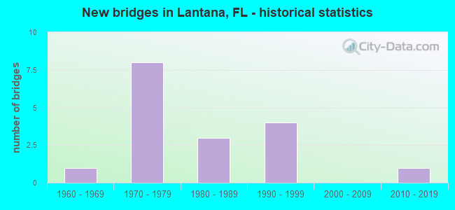
- New bridges - historical statistics
- 11960-1969
- 81970-1979
- 31980-1989
- 41990-1999
- 12010-2019
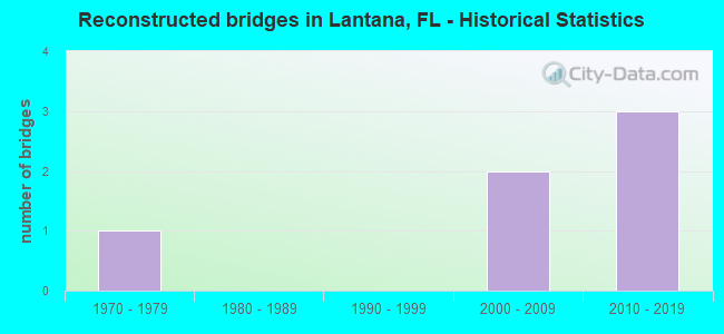
- Reconstructed bridges - Historical Statistics
- 11970-1979
- 01980-1989
- 01990-1999
- 22000-2009
- 32010-2019
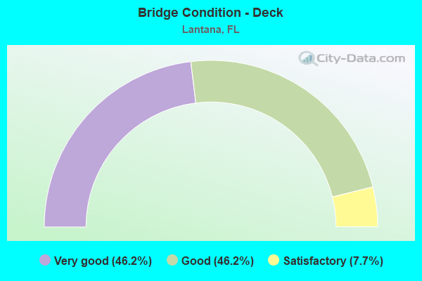
- Bridge Condition - Deck
- 46.2%Very good
- 46.2%Good
- 7.7%Satisfactory
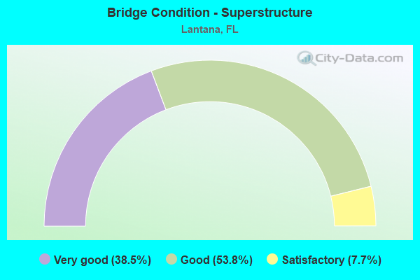
- Bridge Condition - Superstructure
- 38.5%Very good
- 53.8%Good
- 7.7%Satisfactory
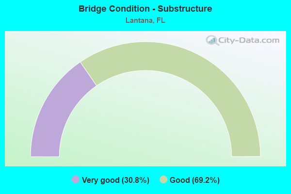
- Bridge Condition - Substructure
- 30.8%Very good
- 69.2%Good
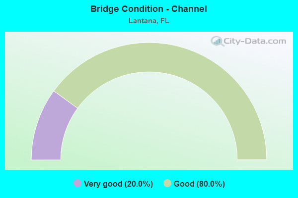
- Bridge Condition - Channel
- 20.0%Very good
- 80.0%Good
Find on map >> Show street view
Structure Number: 930274, Location: Lantana I 95 Interchange (Lat: 26.586694, Lng: -80.069514), Route carried "on" structure: Ramp Interstate 95, Year Built: 1975, Year Reconstructed: 2014, Status: Open, Structure Length: 9.73m (31.92ft), Average Daily Traffic: 11,500 (year 2020), Truck Traffic: 7%, Average Future Daily Traffic: 19,952 (year 2042), Design Load: HS 20+Mod, Features Intersected: Lantana Road
Minimum Vertical Clearance: 5.74m (18.83ft), Kilometerpoint: 0.000, Lanes on structure: 1, Owner: State Highway Agency, Approaching Roadway Width: 9.8m (32.2ft), Material/Design: Prestressed concrete, Design/Construction: Stringer/Multi-beam, Number Of Spans In Main Unit: 6, Length of Maximum Span: 20.6m (67.6ft), Curb-To-Curb Width: 9.8m (32.2ft), Out-to-Out Width: 10.5m (34.4ft)
Condition: Deck: Good, Superstructure: Very good, Substructure: Very good, Operating Rating: 86.3 metric tons, Method Used To Determine Operating Rating: Load Factor (LF), Inventory Rating: 51.7 metric tons, Method Used To Determine Inventory Rating: Load Factor (LF), Structural Evaluation: Equal to present desirable criteria, Deck Geometry: Superior to present desirable criteria, Approach Roadway Alignment: Equal to present desirable criteria, Designated Inspection Frequency: Every 24 months, Inspection Date: May 2020, Deck Structure Type: Concrete Cast-file-Place
Find on map >> Show street view
Structure Number: 930275, Location: Lantana I 95 Interchange (Lat: 26.587919, Lng: -80.069444), Route carried "on" structure: Ramp Interstate 95, Year Built: 1975, Year Reconstructed: 2014, Status: Open, Structure Length: 9.83m (32.25ft), Average Daily Traffic: 11,000 (year 2020), Truck Traffic: 7%, Average Future Daily Traffic: 19,085 (year 2042), Design Load: HS 20+Mod, Features Intersected: Lantana Road
Minimum Vertical Clearance: 30+ m (98+ ft), Kilometerpoint: 0.204, Lanes on structure: 3, Owner: State Highway Agency, Approaching Roadway Width: 15.8m (51.8ft), Material/Design: Prestressed concrete, Design/Construction: Stringer/Multi-beam, Number Of Spans In Main Unit: 6, Length of Maximum Span: 20.6m (67.6ft), Curb-To-Curb Width: 15.8m (51.8ft), Out-to-Out Width: 16.8m (55.1ft)
Condition: Deck: Very good, Superstructure: Good, Substructure: Good, Operating Rating: 88.2 metric tons, Method Used To Determine Operating Rating: Load Factor (LF), Inventory Rating: 52.9 metric tons, Method Used To Determine Inventory Rating: Load Factor (LF), Structural Evaluation: Better than present minimum criteria, Deck Geometry: Superior to present desirable criteria, Approach Roadway Alignment: Equal to present desirable criteria, Designated Inspection Frequency: Every 24 months, Inspection Date: May 2020, Deck Structure Type: Concrete Cast-file-Place
Find on map >> Show street view
Structure Number: 930276, Location: Lantana I 95 Interchange (Lat: 26.587222, Lng: -80.069028), Route carried "on" structure: State highway 812, Year Built: 1975, Status: Open, Structure Length: 14.36m (47.11ft), Average Daily Traffic: 43,000 (year 2020), Truck Traffic: 6%, Average Future Daily Traffic: 74,605 (year 2042), Design Load: HS 20+Mod, Features Intersected: I 95 and CSX Railroad
Minimum Vertical Clearance: 5.74m (18.83ft), Kilometerpoint: 4.958, Lanes on structure: 6, Lanes under structure: 10, Owner: State Highway Agency, Approaching Roadway Width: 21.9m (71.9ft), Skew: 20 degrees, Material/Design: Prestressed concrete, Design/Construction: Stringer/Multi-beam, Number Of Spans In Main Unit: 6, Length of Maximum Span: 30.6m (100.4ft), Curb or Sidewalk Widths: Left: 1.5m (4.9ft), Right: 1.5m (4.9ft), Curb-To-Curb Width: 25.5m (83.7ft), Out-to-Out Width: 29.2m (95.8ft)
Condition: Deck: Very good, Superstructure: Good, Substructure: Good, Operating Rating: 57.4 metric tons, Method Used To Determine Operating Rating: Load Factor (LF), Inventory Rating: 34.5 metric tons, Method Used To Determine Inventory Rating: Load Factor (LF), Structural Evaluation: Better than present minimum criteria, Deck Geometry: Somewhat better than minimum adequacy, Underclear: Somewhat better than minimum adequacy, Approach Roadway Alignment: Equal to present desirable criteria, Designated Inspection Frequency: Every 24 months, Inspection Date: May 2020, Deck Structure Type: Concrete Cast-file-Place, Wearing Surface/Protective System: Wearing Surface: Bituminous
Find on map >> Show street view
Structure Number: 930298, Location: Hypoluxo Rd I 95 Interch (Lat: 26.571639, Lng: -80.069847), Route carried "on" structure: Ramp Interstate 95, Year Built: 1975, Year Reconstructed: 2017, Status: Open, Structure Length: 10.34m (33.92ft), Average Daily Traffic: 6,400 (year 2020), Truck Traffic: 5%, Average Future Daily Traffic: 15,000 (year 2042), Design Load: HS 20+Mod, Features Intersected: Hypoluxo Road
Minimum Vertical Clearance: 30+ m (98+ ft), Kilometerpoint: 0.000, Lanes on structure: 1, Owner: State Highway Agency, Approaching Roadway Width: 14.3m (46.9ft), Material/Design: Prestressed concrete, Design/Construction: Stringer/Multi-beam, Number Of Spans In Main Unit: 6, Length of Maximum Span: 20.6m (67.6ft), Curb-To-Curb Width: 9.8m (32.2ft), Out-to-Out Width: 11.8m (38.7ft)
Condition: Deck: Very good, Superstructure: Good, Substructure: Good, Operating Rating: 44.7 metric tons, Method Used To Determine Operating Rating: Load and Resistance Factor (LRFR), Inventory Rating: 22.9 metric tons, Method Used To Determine Inventory Rating: Load and Resistance Factor (LRFR), Structural Evaluation: Somewhat better than minimum adequacy, Deck Geometry: Superior to present desirable criteria, Approach Roadway Alignment: Equal to present desirable criteria, Designated Inspection Frequency: Every 24 months, Inspection Date: July 2020, Deck Structure Type: Concrete Cast-file-Place
Find on map >> Show street view
Structure Number: 930299, Location: Hypoluxo Rd.-I95 intercha (Lat: 26.573039, Lng: -80.069814), Route carried "on" structure: Ramp Interstate 95, Year Built: 1975, Year Reconstructed: 2017, Status: Open, Structure Length: 14.20m (46.59ft), Average Daily Traffic: 14,000 (year 2020), Truck Traffic: 7%, Average Future Daily Traffic: 24,290 (year 2042), Design Load: HS 20+Mod, Features Intersected: Hypoluxo Rd.
Minimum Vertical Clearance: 30+ m (98+ ft), Kilometerpoint: 0.285, Lanes on structure: 3, Owner: State Highway Agency, Approaching Roadway Width: 16.5m (54.1ft), Material/Design: Prestressed concrete, Design/Construction: Stringer/Multi-beam, Number Of Spans In Main Unit: 8, Length of Maximum Span: 20.6m (67.6ft), Curb-To-Curb Width: 16.5m (54.1ft), Out-to-Out Width: 17.4m (57.1ft)
Condition: Deck: Good, Superstructure: Good, Substructure: Good, Operating Rating: 42.5 metric tons, Method Used To Determine Operating Rating: Load and Resistance Factor (LRFR), Inventory Rating: 30.4 metric tons, Method Used To Determine Inventory Rating: Load and Resistance Factor (LRFR), Structural Evaluation: Better than present minimum criteria, Deck Geometry: Superior to present desirable criteria, Approach Roadway Alignment: Equal to present desirable criteria, Designated Inspection Frequency: Every 24 months, Inspection Date: July 2020, Deck Structure Type: Concrete Cast-file-Place
Find on map >> Show street view
Structure Number: 930307, Location: Hypoluxo Rd over I 95&RR (Lat: 26.572222, Lng: -80.069444), Route carried "on" structure: City street , Year Built: 1974, Year Reconstructed: 2018, Status: Open, Structure Length: 13.54m (44.42ft), Average Daily Traffic: 37,000 (year 2020), Truck Traffic: 6%, Average Future Daily Traffic: 64,195 (year 2042), Design Load: HS 20+Mod, Features Intersected: I-95 (SR-9)/CSXRR, Facility Carried by Structure: Hypoluxo Rd
Minimum Vertical Clearance: 30+ m (98+ ft), Kilometerpoint: 0.000, Lanes on structure: 7, Lanes under structure: 10, Owner: State Highway Agency, Approaching Roadway Width: 27.4m (89.9ft), Material/Design: Prestressed concrete, Design/Construction: Stringer/Multi-beam, Number Of Spans In Main Unit: 6, Length of Maximum Span: 30.5m (100.1ft), Curb or Sidewalk Widths: Left: 1.8m (5.9ft), Right: 1.8m (5.9ft), Curb-To-Curb Width: 27.4m (89.9ft), Out-to-Out Width: 31.6m (103.7ft)
Condition: Deck: Good, Superstructure: Very good, Substructure: Good, Operating Rating: 51.9 metric tons, Method Used To Determine Operating Rating: Load and Resistance Factor (LRFR), Inventory Rating: 27.4 metric tons, Method Used To Determine Inventory Rating: Load and Resistance Factor (LRFR), Structural Evaluation: Equal to present minimum criteria, Deck Geometry: Somewhat better than minimum adequacy, Underclear: Meets minimum limits, Approach Roadway Alignment: Better than present minimum criteria, Designated Inspection Frequency: Every 24 months, Inspection Date: July 2020, Deck Structure Type: Concrete Cast-file-Place, Wearing Surface/Protective System: Wearing Surface: Bituminous
Find on map >> Show street view
Structure Number: 931002, Location: 2.1 M S OF LAKEWORTH INTR (Lat: 26.590403, Lng: -80.173269), Route carried "on" structure: State highway 91, Year Built: 1999, Status: Open, Structure Length: 4.04m (13.25ft), Average Daily Traffic: 35,800 (year 2021), Truck Traffic: 16%, Average Future Daily Traffic: 62,113 (year 2042), Design Load: HS 20, Features Intersected: CR 812 LANTANA RD
Minimum Vertical Clearance: 30+ m (98+ ft), Kilometerpoint: 29.049, Lanes on structure: 2, Lanes under structure: 4, Base Highway Network: Yes, Toll: On toll road, Owner: State Toll Authority, Approaching Roadway Width: 17.7m (58.1ft), Material/Design: Prestressed concrete, Design/Construction: Stringer/Multi-beam, Number Of Spans In Main Unit: 1, Length of Maximum Span: 40.4m (132.5ft), Curb-To-Curb Width: 16.8m (55.1ft), Out-to-Out Width: 17.9m (58.7ft)
Condition: Deck: Very good, Superstructure: Very good, Substructure: Very good, Operating Rating: 86.6 metric tons, Method Used To Determine Operating Rating: Load Factor (LF), Inventory Rating: 61.7 metric tons, Method Used To Determine Inventory Rating: Load Factor (LF), Structural Evaluation: Equal to present desirable criteria, Deck Geometry: Superior to present desirable criteria, Underclear: Superior to present desirable criteria, Approach Roadway Alignment: Equal to present desirable criteria, Designated Inspection Frequency: Every 24 months, Inspection Date: November 2021, Deck Structure Type: Concrete Cast-file-Place
Find on map >> Show street view
Structure Number: 931003, Location: 2.1MI S LAKEWORTH INTERCH (Lat: 26.590400, Lng: -80.173425), Route carried "on" structure: State highway 91, Year Built: 1999, Status: Open, Structure Length: 4.05m (13.29ft), Average Daily Traffic: 35,800 (year 2021), Truck Traffic: 16%, Average Future Daily Traffic: 62,113 (year 2042), Design Load: HS 20, Features Intersected: CR 812 LANTANA RD
Minimum Vertical Clearance: 30+ m (98+ ft), Kilometerpoint: 29.049, Lanes on structure: 2, Lanes under structure: 4, Base Highway Network: Yes, Toll: On toll road, Owner: State Toll Authority, Approaching Roadway Width: 17.2m (56.4ft), Material/Design: Prestressed concrete, Design/Construction: Stringer/Multi-beam, Number Of Spans In Main Unit: 1, Length of Maximum Span: 40.5m (132.9ft), Curb-To-Curb Width: 16.8m (55.1ft), Out-to-Out Width: 17.3m (56.8ft)
Condition: Deck: Very good, Superstructure: Very good, Substructure: Very good, Inventory Rating: 66.5 metric tons, Method Used To Determine Inventory Rating: Load Factor (LF), Structural Evaluation: Equal to present desirable criteria, Deck Geometry: Superior to present desirable criteria, Underclear: Superior to present desirable criteria, Approach Roadway Alignment: Equal to present desirable criteria, Designated Inspection Frequency: Every 24 months, Inspection Date: November 2021, Deck Structure Type: Concrete Cast-file-Place
Find on map >> Show street view
Structure Number: 934331, Location: 0.6Mi S OF CR-812 (Lat: 26.579531, Lng: -80.089778), Route carried "on" structure: County highway 807, Year Built: 1984, Status: Open, Structure Length: 1.38m (4.53ft), Average Daily Traffic: 13,900 (year 2020), Truck Traffic: 5%, Average Future Daily Traffic: 19,085 (year 2042), Design Load: HL 93, Features Intersected: LWDD LAT 17 CANAL, Facility Carried by Structure: CONGRESS AVE SB
Minimum Vertical Clearance: 30+ m (98+ ft), Kilometerpoint: 0.818, Lanes on structure: 2, Owner: County Highway Agency, Approaching Roadway Width: 7.8m (25.6ft), Material/Design: Prestressed concrete, Design/Construction: Slab, Number Of Spans In Main Unit: 3, Length of Maximum Span: 4.6m (15.1ft), Curb or Sidewalk Widths: Left: 1.5m (4.9ft), Right: 0.4m (1.3ft), Curb-To-Curb Width: 11.9m (39.0ft), Out-to-Out Width: 14.7m (48.2ft)
Condition: Deck: Good, Superstructure: Good, Substructure: Good, Channel: Good, Operating Rating: 53.5 metric tons, Method Used To Determine Operating Rating: Load and Resistance Factor (LRFR), Inventory Rating: 41.5 metric tons, Method Used To Determine Inventory Rating: Load and Resistance Factor (LRFR), Structural Evaluation: Better than present minimum criteria, Deck Geometry: Better than present minimum criteria, Waterway Adequacy: Equal to present desirable criteria, Approach Roadway Alignment: Equal to present desirable criteria, Designated Inspection Frequency: Every 24 months, Inspection Date: June 2020, Deck Structure Type: Concrete Precast Panels, Wearing Surface/Protective System: Wearing Surface: Bituminous
Find on map >> Show street view
Structure Number: 934332, Location: 0.6Mi S OF CR-812 (Lat: 26.579533, Lng: -80.089608), Route carried "on" structure: County highway 807, Year Built: 1961, Year Reconstructed: 1984, Status: Open, Structure Length: 1.37m (4.49ft), Average Daily Traffic: 22,500 (year 2020), Truck Traffic: 2%, Average Future Daily Traffic: 39,038 (year 2042), Design Load: HS 20, Features Intersected: LWDD LAT CANAL 17, Facility Carried by Structure: CONGRESS AVE NB
Minimum Vertical Clearance: 30+ m (98+ ft), Kilometerpoint: 0.818, Lanes on structure: 2, Base Highway Network: Yes, Owner: County Highway Agency, Approaching Roadway Width: 7.9m (25.9ft), Material/Design: Concrete, Design/Construction: Slab, Number Of Spans In Main Unit: 3, Length of Maximum Span: 4.6m (15.1ft), Curb or Sidewalk Widths: Left: 1.1m (3.6ft), Right: 2.4m (7.9ft), Curb-To-Curb Width: 12.0m (39.4ft), Out-to-Out Width: 16.2m (53.1ft)
Condition: Deck: Satisfactory, Superstructure: Satisfactory, Substructure: Good, Channel: Good, Operating Rating: 51.3 metric tons, Method Used To Determine Operating Rating: Load and Resistance Factor (LRFR), Inventory Rating: 39.6 metric tons, Method Used To Determine Inventory Rating: Load and Resistance Factor (LRFR), Structural Evaluation: Equal to present minimum criteria, Deck Geometry: Better than present minimum criteria, Waterway Adequacy: Equal to present minimum criteria, Approach Roadway Alignment: Better than present minimum criteria, Designated Inspection Frequency: Every 24 months, Inspection Date: June 2020, Deck Structure Type: Concrete Precast Panels, Wearing Surface/Protective System: Wearing Surface: Bituminous
Find on map >> Show street view
Structure Number: 934341, Location: 0.6 MI WEST OF I-95 (Lat: 26.587686, Lng: -80.078283), Route carried "on" structure: County highway 812, Year Built: 1989, Status: Open, Structure Length: 4.15m (13.62ft), Average Daily Traffic: 39,500 (year 2020), Truck Traffic: 5%, Average Future Daily Traffic: 68,533 (year 2042), Design Load: HS 20, Features Intersected: LAKE OSBOURNE, Facility Carried by Structure: LANTANA ROAD WB
Minimum Vertical Clearance: 30+ m (98+ ft), Kilometerpoint: 4.123, Lanes on structure: 3, Owner: County Highway Agency, Approaching Roadway Width: 11.9m (39.0ft), Material/Design: Prestressed concrete, Design/Construction: Slab, Number Of Spans In Main Unit: 4, Length of Maximum Span: 10.4m (34.1ft), Curb or Sidewalk Widths: Left: 2.0m (6.6ft), Right: 0.0m, Curb-To-Curb Width: 11.9m (39.0ft), Out-to-Out Width: 14.7m (48.2ft)
Condition: Deck: Good, Superstructure: Good, Substructure: Good, Channel: Good, Operating Rating: 43.5 metric tons, Method Used To Determine Operating Rating: Load Factor (LF), Inventory Rating: 34.5 metric tons, Method Used To Determine Inventory Rating: Load Factor (LF), Structural Evaluation: Better than present minimum criteria, Deck Geometry: High priority of corrective action, Waterway Adequacy: Equal to present desirable criteria, Approach Roadway Alignment: Equal to present desirable criteria, Designated Inspection Frequency: Every 24 months, Underwater Inspection Frequency: Every 24 months, Inspection Date: June 2020, Underwater Inspection Date: June 2020, Deck Structure Type: Concrete Precast Panels, Wearing Surface/Protective System: Wearing Surface: Bituminous
Find on map >> Show street view
Structure Number: 934342, Location: 0.6 MI W OF I-95 (Lat: 26.587528, Lng: -80.078306), Route carried "on" structure: County highway 812, Year Built: 1989, Status: Open, Structure Length: 4.15m (13.62ft), Average Daily Traffic: 20,958 (year 2020), Truck Traffic: 5%, Average Future Daily Traffic: 36,362 (year 2042), Design Load: HS 20, Features Intersected: LAKE OSBOURNE, Facility Carried by Structure: LANTANA ROAD EB
Minimum Vertical Clearance: 30+ m (98+ ft), Kilometerpoint: 4.123, Lanes on structure: 3, Owner: County Highway Agency, Approaching Roadway Width: 11.9m (39.0ft), Material/Design: Prestressed concrete, Design/Construction: Slab, Number Of Spans In Main Unit: 4, Length of Maximum Span: 10.4m (34.1ft), Curb or Sidewalk Widths: Left: 0.0m, Right: 2.0m (6.6ft), Curb-To-Curb Width: 11.9m (39.0ft), Out-to-Out Width: 14.7m (48.2ft)
Condition: Deck: Good, Superstructure: Good, Substructure: Good, Channel: Good, Operating Rating: 43.5 metric tons, Method Used To Determine Operating Rating: Load Factor (LF), Inventory Rating: 34.5 metric tons, Method Used To Determine Inventory Rating: Load Factor (LF), Structural Evaluation: Better than present minimum criteria, Deck Geometry: High priority of corrective action, Waterway Adequacy: Equal to present desirable criteria, Approach Roadway Alignment: Equal to present desirable criteria, Designated Inspection Frequency: Every 24 months, Underwater Inspection Frequency: Every 24 months, Inspection Date: June 2020, Underwater Inspection Date: June 2020, Deck Structure Type: Concrete Precast Panels, Wearing Surface/Protective System: Wearing Surface: Bituminous
Find on map >> Show street view
Structure Number: 934369, Location: 0.3 Mile East of US-1 (Lat: 26.584167, Lng: -80.045556), Route carried "on" structure: County highway , Year Built: 2013, Status: Open, Structure Length: 23.93m (78.51ft), Average Daily Traffic: 12,500 (year 2021), Truck Traffic: 6%, Average Future Daily Traffic: 15,000 (year 2042), Design Load: HL 93, Features Intersected: INTRACOASTAL WATERWAY, Facility Carried by Structure: CR-812 OCEAN AVE
Minimum Vertical Clearance: 5.61m (18.41ft), Kilometerpoint: 0.512, Lanes on structure: 2, Owner: County Highway Agency, Approaching Roadway Width: 10.7m (35.1ft), Navigation Control: Yes ( Vertical Clearance: 6.4m (21.0ft), Horizontal Clearance: 38.1m (125.0ft)), Material/Design: Steel, Design/Construction: Movable - Bascule, Number Of Spans In Main Unit: 1, Number Of Approach Spans: 6, Length of Maximum Span: 46.8m (153.5ft), Curb or Sidewalk Widths: Left: 1.8m (5.9ft), Right: 1.8m (5.9ft), Curb-To-Curb Width: 10.7m (35.1ft), Out-to-Out Width: 15.8m (51.8ft)
Condition: Deck: Very good, Superstructure: Very good, Substructure: Very good, Channel: Very good, Operating Rating: 54.5 metric tons, Method Used To Determine Operating Rating: Load and Resistance Factor (LRFR), Inventory Rating: 42.1 metric tons, Method Used To Determine Inventory Rating: Load and Resistance Factor (LRFR), Structural Evaluation: Equal to present desirable criteria, Deck Geometry: Meets minimum limits, Waterway Adequacy: Equal to present desirable criteria, Approach Roadway Alignment: Equal to present minimum criteria, Designated Inspection Frequency: Every 24 months, Critical Feature Inspection Frequency: Every 24 months, Underwater Inspection Frequency: Every 24 months, Other Special Inspection Frequency: Every 12 months, Inspection Date: May 2020, Critical Feature Inspection Date: May 2020, Underwater Inspection Date: May 2020, Other Special Inspection Date: May 2021, Deck Structure Type: Concrete Cast-file-Place, Wearing Surface/Protective System: Wearing Surface: Integral Concrete
Find on map >> Show street view
Structure Number: 930276, Location: Lantana I 95 Interchange (Lat: 26.587222, Lng: -80.069028), Route carried "under" structure: Interstate 95, Year Built: 1975, Structure Length: 0. m, Average Daily Traffic: 250,000 (year 2020), Truck Traffic: 9%, Features Intersected: I 95 and CSX Railroad, Facility Carried by Structure: SR 812 Lantana Rd
Minimum Vertical Clearance: 5.03m (16.50ft), Kilometerpoint: 30.272, Lanes on structure: 6, Lanes under structure: 10, Material/Design: Prestressed concrete, Design/Construction: Stringer/Multi-beam, Length of Maximum Span: 30.6m (100.4ft)
Find on map >> Show street view
Structure Number: 930307, Location: Hypoluxo Rd over I 95&RR (Lat: 26.572222, Lng: -80.069444), Route carried "under" structure: Interstate 95, Year Built: 1974, Structure Length: 0. m, Average Daily Traffic: 250,000 (year 2020), Truck Traffic: 9%, Features Intersected: I-95 (SR-9)/CSXRR, Facility Carried by Structure: Hypoluxo Rd
Minimum Vertical Clearance: 5.66m (18.57ft), Kilometerpoint: 28.608, Lanes on structure: 7, Lanes under structure: 10, Material/Design: Prestressed concrete, Design/Construction: Stringer/Multi-beam, Length of Maximum Span: 30.5m (100.1ft)
Find on map >> Show street view
Structure Number: 931002, Location: 2.1 M S OF LAKEWORTH INTR (Lat: 26.590403, Lng: -80.173269), Route carried "under" structure: County highway 812, Year Built: 1999, Structure Length: 0. m, Average Daily Traffic: 35,800 (year 2021), Truck Traffic: 16%, Features Intersected: CR 812 LANTANA RD, Facility Carried by Structure: SR91 NB TPK 91.26
Minimum Vertical Clearance: 5.82m (19.09ft), Kilometerpoint: 29.098, Lanes on structure: 2, Lanes under structure: 4, Toll: On toll road, Material/Design: Prestressed concrete, Design/Construction: Stringer/Multi-beam, Length of Maximum Span: 40.4m (132.5ft)
Find on map >> Show street view
Structure Number: 931003, Location: 2.1MI S LAKEWORTH INTERCH (Lat: 26.590400, Lng: -80.173425), Route carried "under" structure: County highway 812, Year Built: 1999, Structure Length: 0. m, Average Daily Traffic: 35,800 (year 2021), Truck Traffic: 16%, Features Intersected: CR 812 LANTANA RD, Facility Carried by Structure: SR91 SB TPK 91.26
Minimum Vertical Clearance: 5.70m (18.70ft), Kilometerpoint: 29.098, Lanes on structure: 2, Lanes under structure: 4, Toll: On toll road, Material/Design: Prestressed concrete, Design/Construction: Stringer/Multi-beam, Length of Maximum Span: 40.5m (132.9ft)