Bridge Statistics for Larchmont, New York (NY)
Condition, Traffic, Stress, Structural Evaluation, Project Costs
- National Bridge Inventory (NBI) Statistics
- 11Number of bridges
- 66ft / 19.6mTotal length
- $26,181,000Total costs
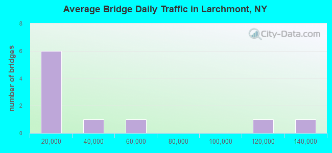
- 366,889Total average daily traffic
- 1,209Total average daily truck traffic
- National Bridge Inventory (NBI) Registered Bridges for Larchmont
- No street view available for this location
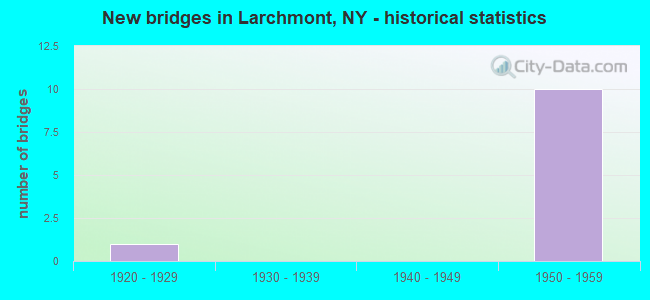
- New bridges - historical statistics
- 11920-1929
- 101950-1959
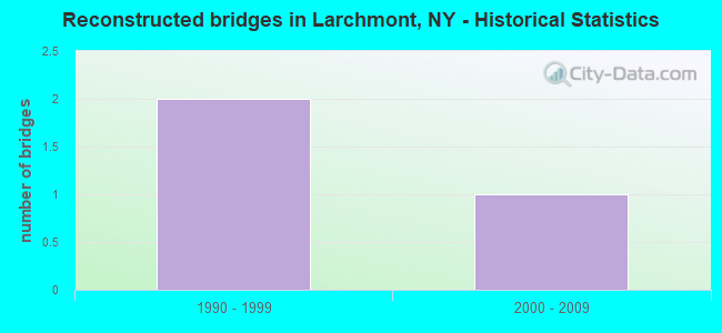
- Reconstructed bridges - Historical Statistics
- 21990-1999
- 12000-2009
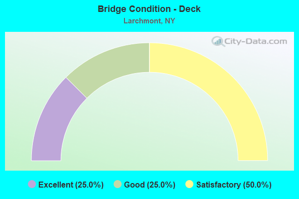
- Bridge Condition - Deck
- 25.0%Excellent
- 25.0%Good
- 50.0%Satisfactory
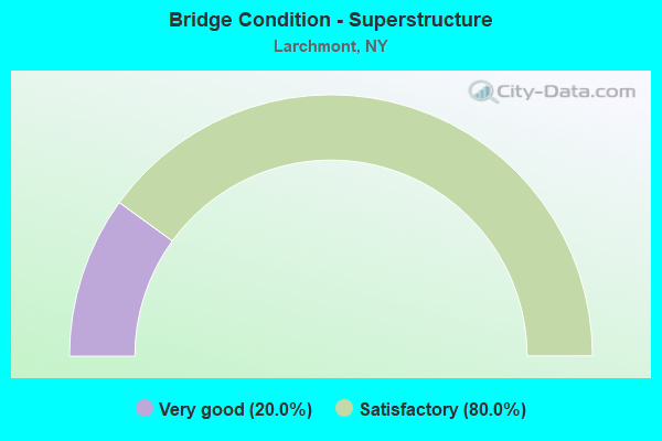
- Bridge Condition - Superstructure
- 20.0%Very good
- 80.0%Satisfactory
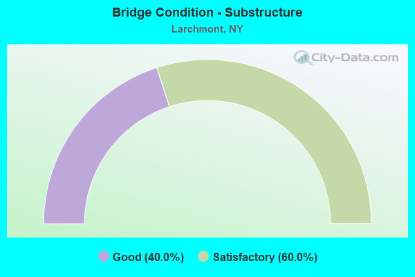
- Bridge Condition - Substructure
- 40.0%Good
- 60.0%Satisfactory
Find on map >> Show street view
Structure Number: 103751, Location: JCT RTS 125+I95 (Lat: 40.939561, Lng: -73.753131), Route carried "on" structure: State highway 125, Year Built: 1957, Year Reconstructed: 2013, Status: Open, Structure Length: 3.47m (11.38ft), Average Daily Traffic: 6,193 (year 2020), Truck Traffic: 6%, Average Future Daily Traffic: 6,222 (year 2040), Design Load: HS 20+Mod, Features Intersected: 95IX NB, RTE I95
Minimum Vertical Clearance: 30+ m (98+ ft), Kilometerpoint: 0.676, Lanes on structure: 2, Lanes under structure: 6, Base Highway Network: Yes, Owner: State Highway Agency, Approaching Roadway Width: 11.0m (36.1ft), Material/Design: Steel, Design/Construction: Stringer/Multi-beam, Number Of Spans In Main Unit: 2, Length of Maximum Span: 16.7m (54.8ft), Curb or Sidewalk Widths: Left: 1.5m (4.9ft), Right: 1.5m (4.9ft), Curb-To-Curb Width: 11.0m (36.1ft), Out-to-Out Width: 14.6m (47.9ft)
Condition: Deck: Excellent, Superstructure: Satisfactory, Substructure: Good, Operating Rating: 91.6 metric tons, Method Used To Determine Operating Rating: Load Factor (LF), Inventory Rating: 54.4 metric tons, Method Used To Determine Inventory Rating: Load Factor (LF), Structural Evaluation: Equal to present minimum criteria, Deck Geometry: Meets minimum limits, Underclear: High priority of corrective action, Approach Roadway Alignment: Equal to present desirable criteria, Length Of Structure Improvement: 3.47m (11.38ft), Designated Inspection Frequency: Every 24 months, Inspection Date: December 2021, Bridge Improvement Cost: $2,954,000, Roadway Improvement Cost: $1,730,000, Total Project Cost: $4,684,000 ( Estimate for 2021), Deck Structure Type: Concrete Cast-file-Place, Wearing Surface/Protective System: Wearing Surface: Integral Concrete, Deck Protection: Epoxy Coated Reinforcing
Find on map >> Show street view
Structure Number: 334825, Location: 0.6 MI NW OF LARCHMONT (Lat: 40.935561, Lng: -73.761122), Route carried "on" structure: Other road , Year Built: 1929, Status: Open, Structure Length: 3.47m (11.38ft), Average Daily Traffic: 4,611 (year 2017), Truck Traffic: 2%, Average Future Daily Traffic: 5,705 (year 2040), Features Intersected: COMMUNITY PARK, Facility Carried by Structure: MURRAY AVENUE
Minimum Vertical Clearance: 30+ m (98+ ft), Kilometerpoint: 0.177, Lanes on structure: 2, Owner: County Highway Agency, Approaching Roadway Width: 16.8m (55.1ft), Material/Design: Concrete, Design/Construction: Frame, Number Of Spans In Main Unit: 2, Length of Maximum Span: 14.9m (48.9ft), Curb or Sidewalk Widths: Left: 3.4m (11.2ft), Right: 3.3m (10.8ft), Curb-To-Curb Width: 16.6m (54.5ft), Out-to-Out Width: 24.3m (79.7ft)
Condition: Superstructure: Satisfactory, Substructure: Satisfactory, Operating Rating: 40.6 metric tons, Method Used To Determine Operating Rating: Field evaluation and documented engineering judgment, Inventory Rating: 15.7 metric tons, Method Used To Determine Inventory Rating: Field evaluation and documented engineering judgment, Structural Evaluation: Meets minimum limits, Deck Geometry: Superior to present desirable criteria, Approach Roadway Alignment: Equal to present desirable criteria, Length Of Structure Improvement: 3.47m (11.38ft), Designated Inspection Frequency: Every 24 months, Inspection Date: March 2021, Bridge Improvement Cost: $3,512,000, Roadway Improvement Cost: $2,057,000, Total Project Cost: $5,568,000 ( Estimate for 2021)
Find on map >> Show street view
Structure Number: 551459, Location: 2.6 MI N JCT I-95 & US-1 (Lat: 40.929450, Lng: -73.765542), Route carried "on" structure: Ramp Other road , Year Built: 1958, Year Reconstructed: 1998, Status: Open, Structure Length: 4.48m (14.70ft), Average Daily Traffic: 1,585 (year 2018), Truck Traffic: 15%, Average Future Daily Traffic: 2,684 (year 2040), Design Load: HS 25 or greater, Features Intersected: I-95 SB, RTE I95, Facility Carried by Structure: CHATSWORTH AVE RAM
Minimum Vertical Clearance: 30+ m (98+ ft), Kilometerpoint: 0.338, Lanes on structure: 1, Lanes under structure: 6, Toll: On Interstate toll segment, Owner: State Toll Authority, Approaching Roadway Width: 7.3m (24.0ft), Skew: 3 degrees, Material/Design: Steel continuous, Design/Construction: Stringer/Multi-beam, Number Of Spans In Main Unit: 2, Length of Maximum Span: 21.6m (70.9ft), Curb-To-Curb Width: 9.1m (29.9ft), Out-to-Out Width: 10.1m (33.1ft)
Condition: Deck: Good, Superstructure: Very good, Substructure: Good, Operating Rating: 84.2 metric tons, Method Used To Determine Operating Rating: Load and Resistance Factor Rating (LRFR) rating reported by rating factor(RF) method using HL-93 loadings, Inventory Rating: 65.1 metric tons, Method Used To Determine Inventory Rating: Load and Resistance Factor Rating (LRFR) rating reported by rating factor(RF) method using HL-93 loadings, Structural Evaluation: Better than present minimum criteria, Deck Geometry: Superior to present desirable criteria, Underclear: High priority of corrective action, Approach Roadway Alignment: Equal to present desirable criteria, Length Of Structure Improvement: 4.48m (14.70ft), Designated Inspection Frequency: Every 24 months, Inspection Date: July 2020, Bridge Improvement Cost: $2,711,000, Roadway Improvement Cost: $1,588,000, Total Project Cost: $4,299,000 ( Estimate for 2021), Deck Structure Type: Concrete Cast-file-Place, Wearing Surface/Protective System: Wearing Surface: Integral Concrete, Deck Protection: Galvanized Reinforcing
Find on map >> Show street view
Structure Number: 55146, Location: LARCHMONT (Lat: 40.933439, Lng: -73.760228), Route carried "on" structure: Other road , Year Built: 1956, Status: Open, Structure Length: 5.67m (18.60ft), Average Daily Traffic: 12,730 (year 2016), Truck Traffic: 4%, Average Future Daily Traffic: 15,464 (year 2040), Design Load: HS 20+Mod, Features Intersected: 95 IX SB, 95IX, MNRR NH, Facility Carried by Structure: CHATSWORTH AVENUE
Minimum Vertical Clearance: 30+ m (98+ ft), Kilometerpoint: 0.016, Lanes on structure: 4, Lanes under structure: 6, Owner: State Toll Authority, Approaching Roadway Width: 15.2m (49.9ft), Skew: 1 degrees, Material/Design: Steel, Design/Construction: Stringer/Multi-beam, Number Of Spans In Main Unit: 4, Length of Maximum Span: 16.8m (55.1ft), Curb or Sidewalk Widths: Left: 2.7m (8.9ft), Right: 2.8m (9.2ft), Curb-To-Curb Width: 15.2m (49.9ft), Out-to-Out Width: 22.3m (73.2ft)
Condition: Deck: Satisfactory, Superstructure: Satisfactory, Substructure: Satisfactory, Operating Rating: 47.2 metric tons, Method Used To Determine Operating Rating: Load Factor (LF), Inventory Rating: 28.1 metric tons, Method Used To Determine Inventory Rating: Load Factor (LF), Structural Evaluation: Equal to present minimum criteria, Deck Geometry: High priority of corrective action, Underclear: Meets minimum limits, Approach Roadway Alignment: Equal to present minimum criteria, Length Of Structure Improvement: 5.66m (18.57ft), Designated Inspection Frequency: Every 24 months, Inspection Date: October 2021, Bridge Improvement Cost: $6,274,000, Roadway Improvement Cost: $3,674,000, Total Project Cost: $9,949,000 ( Estimate for 2021), Deck Structure Type: Concrete Cast-file-Place, Wearing Surface/Protective System: Wearing Surface: Bituminous
Find on map >> Show street view
Structure Number: 551462, Location: 0.12 MI NE CHATSWORTH/I95 (Lat: 40.934864, Lng: -73.758881), Route carried "on" structure: Ramp Other road , Year Built: 1955, Year Reconstructed: 1995, Status: Open, Structure Length: 2.53m (8.30ft), Average Daily Traffic: 3,000 (year 2006), Average Future Daily Traffic: 4,200 (year 2026), Design Load: HS 20, Features Intersected: VINE STREET, Facility Carried by Structure: PARKING PLAZA RMP
Minimum Vertical Clearance: 30+ m (98+ ft), Kilometerpoint: 12.470, Lanes on structure: 2, Lanes under structure: 2, Owner: State Toll Authority, Approaching Roadway Width: 7.3m (24.0ft), Material/Design: Steel, Design/Construction: Stringer/Multi-beam, Number Of Spans In Main Unit: 1, Length of Maximum Span: 24.4m (80.1ft), Curb or Sidewalk Widths: Left: 1.3m (4.3ft), Right: 1.4m (4.6ft), Curb-To-Curb Width: 7.3m (24.0ft), Out-to-Out Width: 10.7m (35.1ft)
Condition: Deck: Satisfactory, Superstructure: Satisfactory, Substructure: Satisfactory, Operating Rating: 91.6 metric tons, Method Used To Determine Operating Rating: Load Factor (LF), Inventory Rating: 54.4 metric tons, Method Used To Determine Inventory Rating: Load Factor (LF), Structural Evaluation: Equal to present minimum criteria, Deck Geometry: High priority of replacement, Underclear: High priority of corrective action, Approach Roadway Alignment: Equal to present minimum criteria, Length Of Structure Improvement: 2.52m (8.27ft), Designated Inspection Frequency: Every 24 months, Inspection Date: April 2020, Bridge Improvement Cost: $1,060,000, Roadway Improvement Cost: $621,000, Total Project Cost: $1,681,000 ( Estimate for 2021), Deck Structure Type: Concrete Cast-file-Place, Wearing Surface/Protective System: Wearing Surface: Bituminous, Membrane: Other
Find on map >> Show street view
Structure Number: 103751, Location: JCT RTS 125+I95 (Lat: 40.939561, Lng: -73.753131), Route carried "under" structure: Interstate 95, Year Built: 1957, Structure Length: 0. m, Average Daily Traffic: 55,000 (year 1975), Features Intersected: 95IX NB, RTE I95, Facility Carried by Structure: RTE 125
Minimum Vertical Clearance: 4.85m (15.91ft), Kilometerpoint: 13.178, Lanes on structure: 2, Lanes under structure: 3, Material/Design: Steel, Design/Construction: Stringer/Multi-beam, Length of Maximum Span: 16.7m (54.8ft)
Find on map >> Show street view
Structure Number: 551459, Location: 2.6 MI N JCT I-95 & US-1 (Lat: 40.929450, Lng: -73.765542), Route carried "under" structure: Interstate 95, Year Built: 1958, Structure Length: 0. m, Average Daily Traffic: 135,270 (year 2008), Features Intersected: I-95 SB, RTE I95, Facility Carried by Structure: CHATSWORTH AVE RAM
Minimum Vertical Clearance: 4.83m (15.85ft), Kilometerpoint: 11.649, Lanes on structure: 1, Lanes under structure: 3, Toll: On Interstate toll segment, Material/Design: Steel continuous, Design/Construction: Stringer/Multi-beam, Length of Maximum Span: 21.6m (70.9ft)
Find on map >> Show street view
Structure Number: 55146, Location: LARCHMONT (Lat: 40.933439, Lng: -73.760228), Route carried "under" structure: Interstate , Year Built: 1956, Structure Length: 0. m, Average Daily Traffic: 108,000 (year 2021), Features Intersected: 95 IX SB, 95IX, MNRR NH, Facility Carried by Structure: CHATSWORTH AVENUE
Minimum Vertical Clearance: 5.41m (17.75ft), Kilometerpoint: 977.693, Lanes on structure: 4, Lanes under structure: 3, Toll: On Interstate toll segment, Material/Design: Steel, Design/Construction: Stringer/Multi-beam, Length of Maximum Span: 16.8m (55.1ft)
Find on map >> Show street view
Structure Number: 551461, Location: 3.0 MI N JCT RTS I-95+1 (Lat: 40.935192, Lng: -73.758233), Route carried "under" structure: Interstate 95, Year Built: 1956, Structure Length: 0. m, Average Daily Traffic: 35,500 (year 2021), Features Intersected: 95IX SB, RTE I95, Facility Carried by Structure: LARCHMONT STA PKG
Minimum Vertical Clearance: 4.65m (15.26ft), Kilometerpoint: 977.821, Lanes under structure: 3, Toll: On Interstate toll segment, Material/Design: Steel, Design/Construction: Stringer/Multi-beam, Length of Maximum Span: 16.2m (53.1ft)
Find on map >> Show street view
Structure Number: 551461, Location: 3.0 MI N JCT RTS I-95+1 (Lat: 40.935192, Lng: -73.758233), Route carried "under" structure: Interstate , Year Built: 1956, Structure Length: 0. m, Features Intersected: 95IX SB, RTE I95, Facility Carried by Structure: LARCHMONT STA PKG
Minimum Vertical Clearance: 4.88m (16.01ft), Kilometerpoint: 977.821, Lanes under structure: 3, Toll: On Interstate toll segment, Material/Design: Steel, Design/Construction: Stringer/Multi-beam, Length of Maximum Span: 16.2m (53.1ft)
Find on map >> Show street view
Structure Number: 551462, Location: 0.12 MI NE CHATSWORTH/I95 (Lat: 40.934864, Lng: -73.758881), Route carried "under" structure: Other road , Year Built: 1955, Structure Length: 0. m, Average Daily Traffic: 5,000 (year 1980), Features Intersected: VINE STREET, Facility Carried by Structure: PARKING PLAZA RMP
Minimum Vertical Clearance: 4.09m (13.42ft), Kilometerpoint: 0.000, Lanes on structure: 2, Lanes under structure: 2, Material/Design: Steel, Design/Construction: Stringer/Multi-beam, Length of Maximum Span: 24.4m (80.1ft)