Bridge Statistics for Lavonia, Georgia (GA)
Condition, Traffic, Stress, Structural Evaluation, Project Costs
- National Bridge Inventory (NBI) Statistics
- 15Number of bridges
- 102ft / 30.9mTotal length
- $7,219,000Total costs
- 107,140Total average daily traffic
- 2,452Total average daily truck traffic
- National Bridge Inventory (NBI) Registered Bridges for Lavonia
- No street view available for this location
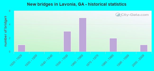
- New bridges - historical statistics
- 11920-1929
- 31950-1959
- 51960-1969
- 21980-1989
- 12000-2009


- Bridge Condition - Substructure
- 75.0%Good
- 25.0%Satisfactory

- Bridge Condition - Channel
- 20.0%Good
- 30.0%Satisfactory
- 50.0%Fair

- Bridge Condition - Culverts
- 87.5%Good
- 12.5%Satisfactory
Find on map >> Show street view
Structure Number: 1190034, Location: 3.5 MI SW OF LAVONIA (Lat: 34.420408, Lng: -83.166100), Route carried "on" structure: County highway 383, Year Built: 1963, Status: Open, Structure Length: 8.84m (29.00ft), Average Daily Traffic: 880 (year 2011), Truck Traffic: 1%, Average Future Daily Traffic: 1,320 (year 2031), Design Load: H 15, Features Intersected: I-85, Facility Carried by Structure: FAIRVIEW ROAD
Minimum Vertical Clearance: 30+ m (98+ ft), Kilometerpoint: 4.828, Lanes on structure: 2, Lanes under structure: 4, Base Highway Network: Yes, Owner: State Highway Agency, Approaching Roadway Width: 6.4m (21.0ft), Skew: 3 degrees, Material/Design: Steel continuous, Design/Construction: Stringer/Multi-beam, Number Of Spans In Main Unit: 4, Length of Maximum Span: 24.1m (79.1ft), Curb or Sidewalk Widths: Left: 0.6m (2.0ft), Right: 0.6m (2.0ft), Curb-To-Curb Width: 7.9m (25.9ft), Out-to-Out Width: 9.7m (31.8ft)
Condition: Deck: Good, Superstructure: Good, Substructure: Good, Operating Rating: 33.5 metric tons, Method Used To Determine Operating Rating: Allowable Stress (AS), Inventory Rating: 17.2 metric tons, Method Used To Determine Inventory Rating: Allowable Stress (AS), Structural Evaluation: Meets minimum limits, Deck Geometry: Somewhat better than minimum adequacy, Underclear: Somewhat better than minimum adequacy, Approach Roadway Alignment: Equal to present minimum criteria, Designated Inspection Frequency: Every 24 months, Inspection Date: September 2020, Bridge Improvement Cost: $1,133,000, Roadway Improvement Cost: $113,000, Total Project Cost: $1,700,000, Deck Structure Type: Concrete Cast-file-Place
Find on map >> Show street view
Structure Number: 1195011, Location: 2.6 MI SW OF LAVONIA (Lat: 34.409028, Lng: -83.138208), Route carried "on" structure: County highway 64, Year Built: 1961, Status: Open, Structure Length: 1.13m (3.71ft), Average Daily Traffic: 210 (year 2011), Truck Traffic: 1%, Average Future Daily Traffic: 315 (year 2031), Design Load: H 15, Features Intersected: BEAR CREEK, Facility Carried by Structure: MCGEE ROAD
Minimum Vertical Clearance: 30+ m (98+ ft), Kilometerpoint: 0.000, Lanes on structure: 2, Base Highway Network: Yes, Owner: County Highway Agency, Approaching Roadway Width: 6.1m (20.0ft), Skew: 3 degrees, Material/Design: Concrete, Design/Construction: Culvert, Number Of Spans In Main Unit: 3, Length of Maximum Span: 3.7m (12.1ft)
Condition: Channel: Fair, Culverts: Good, Operating Rating: 41.7 metric tons, Method Used To Determine Operating Rating: Field evaluation and documented engineering judgment, Inventory Rating: 24.4 metric tons, Method Used To Determine Inventory Rating: Field evaluation and documented engineering judgment, Structural Evaluation: Equal to present minimum criteria, Waterway Adequacy: Superior to present desirable criteria, Approach Roadway Alignment: Better than present minimum criteria, Designated Inspection Frequency: Every 24 months, Inspection Date: August 2020, Bridge Improvement Cost: $145,000, Roadway Improvement Cost: $14,000, Total Project Cost: $217,000
Find on map >> Show street view
Structure Number: 1195012, Location: 1.3 MI SW OF LAVONIA (Lat: 34.421319, Lng: -83.120469), Route carried "on" structure: County highway 66, Year Built: 1980, Status: Open, Structure Length: 0.64m (2.10ft), Average Daily Traffic: 340 (year 2011), Truck Traffic: 1%, Average Future Daily Traffic: 510 (year 2031), Design Load: HS 20+Mod, Features Intersected: BEAR CREEK, Facility Carried by Structure: ALLEN FARM ROAD
Minimum Vertical Clearance: 30+ m (98+ ft), Kilometerpoint: 0.000, Lanes on structure: 2, Base Highway Network: Yes, Owner: County Highway Agency, Approaching Roadway Width: 6.4m (21.0ft), Skew: 1 degrees, Material/Design: Concrete, Design/Construction: Culvert, Number Of Spans In Main Unit: 2, Length of Maximum Span: 3.0m (9.8ft)
Condition: Channel: Good, Culverts: Good, Operating Rating: 55.3 metric tons, Method Used To Determine Operating Rating: Field evaluation and documented engineering judgment, Inventory Rating: 32.6 metric tons, Method Used To Determine Inventory Rating: Field evaluation and documented engineering judgment, Structural Evaluation: Better than present minimum criteria, Waterway Adequacy: Better than present minimum criteria, Approach Roadway Alignment: Equal to present minimum criteria, Designated Inspection Frequency: Every 24 months, Inspection Date: August 2020, Bridge Improvement Cost: $82,000, Roadway Improvement Cost: $8,000, Total Project Cost: $123,000
Find on map >> Show street view
Structure Number: 1195013, Location: 3 MI SW OF LAVONIA (Lat: 34.402519, Lng: -83.142028), Route carried "on" structure: County highway 74, Year Built: 1963, Status: Open, Structure Length: 1.34m (4.40ft), Average Daily Traffic: 310 (year 2011), Truck Traffic: 1%, Average Future Daily Traffic: 465 (year 2031), Design Load: H 15, Features Intersected: UNAWATTI CREEK, Facility Carried by Structure: GRADY SCHOOL RD
Minimum Vertical Clearance: 30+ m (98+ ft), Kilometerpoint: 4.828, Lanes on structure: 2, Base Highway Network: Yes, Owner: County Highway Agency, Approaching Roadway Width: 6.7m (22.0ft), Material/Design: Concrete, Design/Construction: Culvert, Number Of Spans In Main Unit: 4, Length of Maximum Span: 3.0m (9.8ft)
Condition: Channel: Satisfactory, Culverts: Satisfactory, Operating Rating: 41.7 metric tons, Method Used To Determine Operating Rating: Field evaluation and documented engineering judgment, Inventory Rating: 24.4 metric tons, Method Used To Determine Inventory Rating: Field evaluation and documented engineering judgment, Structural Evaluation: Equal to present minimum criteria, Waterway Adequacy: Better than present minimum criteria, Approach Roadway Alignment: Better than present minimum criteria, Designated Inspection Frequency: Every 24 months, Inspection Date: August 2020, Bridge Improvement Cost: $172,000, Roadway Improvement Cost: $17,000, Total Project Cost: $258,000
Find on map >> Show street view
Structure Number: 1195014, Location: 3.4 MI SW OF LAVONIA (Lat: 34.408689, Lng: -83.156278), Route carried "on" structure: County highway 74, Year Built: 1962, Status: Open, Structure Length: 0.64m (2.10ft), Average Daily Traffic: 290 (year 2011), Truck Traffic: 1%, Average Future Daily Traffic: 435 (year 2031), Design Load: H 15, Features Intersected: UNAWATTI CREEK TRIB, Facility Carried by Structure: GRADY SCHOOL RD
Minimum Vertical Clearance: 30+ m (98+ ft), Kilometerpoint: 6.437, Lanes on structure: 2, Base Highway Network: Yes, Owner: County Highway Agency, Approaching Roadway Width: 6.1m (20.0ft), Material/Design: Concrete, Design/Construction: Culvert, Number Of Spans In Main Unit: 2, Length of Maximum Span: 3.0m (9.8ft)
Condition: Channel: Good, Culverts: Good, Operating Rating: 41.7 metric tons, Method Used To Determine Operating Rating: Field evaluation and documented engineering judgment, Inventory Rating: 24.4 metric tons, Method Used To Determine Inventory Rating: Field evaluation and documented engineering judgment, Structural Evaluation: Equal to present minimum criteria, Waterway Adequacy: Better than present minimum criteria, Approach Roadway Alignment: Equal to present desirable criteria, Designated Inspection Frequency: Every 24 months, Inspection Date: August 2020, Bridge Improvement Cost: $82,000, Roadway Improvement Cost: $8,000, Total Project Cost: $123,000
Find on map >> Show street view
Structure Number: 1195076, Location: 4 MI SW OF LAVONIA (Lat: 34.390928, Lng: -83.162428), Route carried "on" structure: County highway 384, Year Built: 1963, Status: Open, Structure Length: 0.98m (3.22ft), Average Daily Traffic: 830 (year 2011), Truck Traffic: 1%, Average Future Daily Traffic: 1,245 (year 2031), Design Load: H 15, Features Intersected: UNAWATTI CREEK TRIB, Facility Carried by Structure: STONE BRIDGE RD
Minimum Vertical Clearance: 30+ m (98+ ft), Kilometerpoint: 6.437, Lanes on structure: 2, Base Highway Network: Yes, Owner: County Highway Agency, Approaching Roadway Width: 6.4m (21.0ft), Material/Design: Concrete, Design/Construction: Culvert, Number Of Spans In Main Unit: 3, Length of Maximum Span: 3.0m (9.8ft)
Condition: Channel: Fair, Culverts: Good, Operating Rating: 41.7 metric tons, Method Used To Determine Operating Rating: Field evaluation and documented engineering judgment, Inventory Rating: 24.4 metric tons, Method Used To Determine Inventory Rating: Field evaluation and documented engineering judgment, Structural Evaluation: Equal to present minimum criteria, Waterway Adequacy: Better than present minimum criteria, Approach Roadway Alignment: Better than present minimum criteria, Designated Inspection Frequency: Every 24 months, Inspection Date: September 2020, Bridge Improvement Cost: $125,000, Roadway Improvement Cost: $13,000, Total Project Cost: $188,000
Find on map >> Show street view
Structure Number: 1195093, Location: 2.7 MI SW LAVONIA (Lat: 34.423069, Lng: -83.152289), Route carried "on" structure: State highway 59, Year Built: 1928, Year Reconstructed: 1958, Status: Open, Structure Length: 0.70m (2.30ft), Average Daily Traffic: 2,420 (year 2011), Truck Traffic: 1%, Average Future Daily Traffic: 3,630 (year 2031), Design Load: H 15, Features Intersected: UNIWATTI CREEK TRIB
Minimum Vertical Clearance: 30+ m (98+ ft), Kilometerpoint: 27.359, Lanes on structure: 2, Base Highway Network: Yes, Owner: State Highway Agency, Approaching Roadway Width: 7.6m (24.9ft), Skew: 4 degrees, Material/Design: Concrete, Design/Construction: Culvert, Number Of Spans In Main Unit: 2, Length of Maximum Span: 3.4m (11.2ft)
Condition: Channel: Satisfactory, Culverts: Good, Operating Rating: 59.8 metric tons, Method Used To Determine Operating Rating: Load Factor (LF), Inventory Rating: 36.2 metric tons, Method Used To Determine Inventory Rating: Load Factor (LF), Structural Evaluation: Better than present minimum criteria, Waterway Adequacy: Equal to present minimum criteria, Approach Roadway Alignment: Better than present minimum criteria, Designated Inspection Frequency: Every 24 months, Inspection Date: October 2020, Bridge Improvement Cost: $90,000, Roadway Improvement Cost: $9,000, Total Project Cost: $135,000
Find on map >> Show street view
Structure Number: 1195107, Location: 1 MI NW OF LAVONIA (Lat: 34.446897, Lng: -83.122189), Route carried "on" structure: State highway 17, Year Built: 2006, Status: Open, Structure Length: 12.10m (39.70ft), Average Daily Traffic: 7,190 (year 2011), Truck Traffic: 1%, Average Future Daily Traffic: 10,785 (year 2031), Design Load: HS 20+Mod, Features Intersected: SR 403, I 85
Minimum Vertical Clearance: 30+ m (98+ ft), Kilometerpoint: 22.531, Lanes on structure: 4, Lanes under structure: 5, Base Highway Network: Yes, Owner: State Highway Agency, Approaching Roadway Width: 25.0m (82.0ft), Skew: 23 degrees, Material/Design: Prestressed concrete, Design/Construction: Stringer/Multi-beam, Number Of Spans In Main Unit: 4, Length of Maximum Span: 37.8m (124.0ft), Curb or Sidewalk Widths: Left: 1.8m (5.9ft), Right: 1.8m (5.9ft), Curb-To-Curb Width: 28.0m (91.9ft), Out-to-Out Width: 32.3m (106.0ft)
Condition: Deck: Good, Superstructure: Good, Substructure: Good, Operating Rating: 60.7 metric tons, Method Used To Determine Operating Rating: Allowable Stress (AS), Inventory Rating: 32.6 metric tons, Method Used To Determine Inventory Rating: Allowable Stress (AS), Structural Evaluation: Better than present minimum criteria, Deck Geometry: Superior to present desirable criteria, Underclear: Superior to present desirable criteria, Approach Roadway Alignment: Equal to present desirable criteria, Designated Inspection Frequency: Every 24 months, Inspection Date: September 2020, Bridge Improvement Cost: $2,397,000, Roadway Improvement Cost: $240,000, Total Project Cost: $3,596,000, Deck Structure Type: Concrete Cast-file-Place
Find on map >> Show street view
Structure Number: 1470011, Location: 3.7 MI N OF BOWERSVILLE (Lat: 34.424750, Lng: -83.073569), Route carried "on" structure: State highway 77, Year Built: 1952, Status: Open, Structure Length: 1.13m (3.71ft), Average Daily Traffic: 2,940 (year 2011), Truck Traffic: 7%, Average Future Daily Traffic: 4,410 (year 2031), Design Load: H 15, Features Intersected: POOLES CREEK
Minimum Vertical Clearance: 30+ m (98+ ft), Kilometerpoint: 4.828, Lanes on structure: 2, Base Highway Network: Yes, Owner: State Highway Agency, Approaching Roadway Width: 7.3m (24.0ft), Skew: 3 degrees, Material/Design: Concrete, Design/Construction: Culvert, Number Of Spans In Main Unit: 3, Length of Maximum Span: 3.7m (12.1ft)
Condition: Channel: Fair, Culverts: Good, Operating Rating: 41.7 metric tons, Method Used To Determine Operating Rating: Field evaluation and documented engineering judgment, Inventory Rating: 24.4 metric tons, Method Used To Determine Inventory Rating: Field evaluation and documented engineering judgment, Structural Evaluation: Equal to present minimum criteria, Waterway Adequacy: Equal to present desirable criteria, Approach Roadway Alignment: Equal to present minimum criteria, Designated Inspection Frequency: Every 24 months, Inspection Date: December 2020, Bridge Improvement Cost: $145,000, Roadway Improvement Cost: $14,000, Total Project Cost: $217,000
Find on map >> Show street view
Structure Number: 147504, Location: 3.4 MI N OF BOWERSVILLE (Lat: 34.420758, Lng: -83.086369), Route carried "on" structure: County highway 194, Year Built: 1988, Status: Posted for load, Structure Length: 0.82m (2.69ft), Average Daily Traffic: 240 (year 2011), Truck Traffic: 1%, Average Future Daily Traffic: 360 (year 2031), Features Intersected: POOLES CREEK
Minimum Vertical Clearance: 30+ m (98+ ft), Kilometerpoint: 1.609, Lanes on structure: 2, Base Highway Network: Yes, Owner: County Highway Agency, Approaching Roadway Width: 6.1m (20.0ft), Material/Design: Steel, Design/Construction: Stringer/Multi-beam, Number Of Spans In Main Unit: 1, Length of Maximum Span: 8.2m (26.9ft), Curb-To-Curb Width: 6.2m (20.3ft), Out-to-Out Width: 6.2m (20.3ft)
Condition: Deck: Good, Superstructure: Good, Substructure: Good, Channel: Satisfactory, Operating Rating: 31.7 metric tons, Method Used To Determine Operating Rating: Load Factor (LF), Inventory Rating: 19.0 metric tons, Method Used To Determine Inventory Rating: Load Factor (LF), Structural Evaluation: Somewhat better than minimum adequacy, Deck Geometry: Meets minimum limits, Waterway Adequacy: Equal to present minimum criteria, Approach Roadway Alignment: Equal to present desirable criteria, Bridge Posting: Required (Relationship of Operating Rating to Maximum Legal Load: 10.0 - 19.9% below), Length Of Structure Improvement: 7.22m (23.69ft), Designated Inspection Frequency: Every 24 months, Inspection Date: December 2020, Bridge Improvement Cost: $105,000, Roadway Improvement Cost: $11,000, Total Project Cost: $158,000, Deck Structure Type: Concrete Cast-file-Place, Wearing Surface/Protective System: Wearing Surface: Bituminous
Find on map >> Show street view
Structure Number: 1475041, Location: 4.9 MI NE OF BOWERSVILLE (Lat: 34.433869, Lng: -83.042247), Route carried "on" structure: County highway 196, Year Built: 1959, Status: Open, Structure Length: 1.25m (4.10ft), Average Daily Traffic: 490 (year 2012), Truck Traffic: 1%, Average Future Daily Traffic: 735 (year 2032), Features Intersected: SHOAL CREEK, Facility Carried by Structure: REED ROAD
Minimum Vertical Clearance: 30+ m (98+ ft), Kilometerpoint: 1.609, Lanes on structure: 2, Base Highway Network: Yes, Owner: County Highway Agency, Approaching Roadway Width: 6.1m (20.0ft), Skew: 3 degrees, Material/Design: Steel, Design/Construction: Stringer/Multi-beam, Number Of Spans In Main Unit: 1, Length of Maximum Span: 12.5m (41.0ft), Curb-To-Curb Width: 6.1m (20.0ft), Out-to-Out Width: 6.6m (21.7ft)
Condition: Deck: Good, Superstructure: Good, Substructure: Satisfactory, Channel: Fair, Operating Rating: 41.7 metric tons, Method Used To Determine Operating Rating: Load Factor (LF), Inventory Rating: 24.4 metric tons, Method Used To Determine Inventory Rating: Load Factor (LF), Structural Evaluation: Equal to present minimum criteria, Deck Geometry: High priority of corrective action, Waterway Adequacy: Equal to present desirable criteria, Approach Roadway Alignment: Equal to present minimum criteria, Length Of Structure Improvement: 41.45m (135.99ft), Designated Inspection Frequency: Every 24 months, Underwater Inspection Frequency: Every 60 months, Inspection Date: December 2020, Underwater Inspection Date: October 2021, Bridge Improvement Cost: $160,000, Roadway Improvement Cost: $16,000, Total Project Cost: $240,000, Deck Structure Type: Concrete Cast-file-Place, Wearing Surface/Protective System: Wearing Surface: Bituminous
Find on map >> Show street view
Structure Number: 1475042, Location: 4.4 MI N OF BOWERSVILLE (Lat: 34.434697, Lng: -83.068397), Route carried "on" structure: County highway 197, Year Built: 1958, Status: Open, Structure Length: 1.37m (4.49ft), Average Daily Traffic: 160 (year 2011), Truck Traffic: 1%, Average Future Daily Traffic: 240 (year 2031), Design Load: H 15, Features Intersected: POOLES CREEK, Facility Carried by Structure: SHOAL CREEK ROAD
Minimum Vertical Clearance: 30+ m (98+ ft), Kilometerpoint: 1.609, Lanes on structure: 2, Base Highway Network: Yes, Owner: County Highway Agency, Approaching Roadway Width: 6.4m (21.0ft), Skew: 4 degrees, Material/Design: Concrete, Design/Construction: Culvert, Number Of Spans In Main Unit: 3, Length of Maximum Span: 4.3m (14.1ft)
Condition: Channel: Fair, Culverts: Good, Operating Rating: 41.7 metric tons, Method Used To Determine Operating Rating: Field evaluation and documented engineering judgment, Inventory Rating: 24.4 metric tons, Method Used To Determine Inventory Rating: Field evaluation and documented engineering judgment, Structural Evaluation: Equal to present minimum criteria, Waterway Adequacy: Equal to present desirable criteria, Approach Roadway Alignment: Equal to present minimum criteria, Designated Inspection Frequency: Every 24 months, Inspection Date: December 2020, Bridge Improvement Cost: $176,000, Roadway Improvement Cost: $18,000, Total Project Cost: $264,000
Find on map >> Show street view
Structure Number: 1190034, Location: 3.5 MI SW OF LAVONIA (Lat: 34.420408, Lng: -83.166100), Route carried "under" structure: Interstate 85, Structure Length: 0. m, Average Daily Traffic: 35,800 (year 1999), Truck Traffic: 1%, Features Intersected: CR 383 FAIRVIEW ROAD, Facility Carried by Structure: FAIRVIEW ROAD
Minimum Vertical Clearance: 5.02m (16.47ft), Kilometerpoint: 273.589, Lanes on structure: 2, Length of Maximum Span: 0.0m
Find on map >> Show street view
Structure Number: 119005, Location: 1 MI NW OF LAVONIA (Lat: 34.447378, Lng: -83.120958), Route carried "under" structure: Interstate 85, Structure Length: 0. m, Average Daily Traffic: 37,740 (year 2011), Truck Traffic: 1%, Features Intersected: I-85, Facility Carried by Structure: HARTWELL RAILROAD
Minimum Vertical Clearance: 5.08m (16.67ft), Kilometerpoint: 278.417, Length of Maximum Span: 0.0m
Find on map >> Show street view
Structure Number: 1195107, Location: 1 MI NW OF LAVONIA (Lat: 34.446897, Lng: -83.122189), Route carried "under" structure: Interstate 85, Structure Length: 0. m, Average Daily Traffic: 17,300 (year 2005), Truck Traffic: 8%, Features Intersected: SR17, Facility Carried by Structure: SR 17
Minimum Vertical Clearance: 5.61m (18.41ft), Kilometerpoint: 278.417, Lanes on structure: 4, Length of Maximum Span: 0.0m