Bridge Statistics for Lawnside, New Jersey (NJ)
Condition, Traffic, Stress, Structural Evaluation, Project Costs
- National Bridge Inventory (NBI) Statistics
- 13Number of bridges
- 105ft / 32.3mTotal length
- $2,028,000Total costs
- 497,333Total average daily traffic
- 48,179Total average daily truck traffic
- National Bridge Inventory (NBI) Registered Bridges for Lawnside
- No street view available for this location
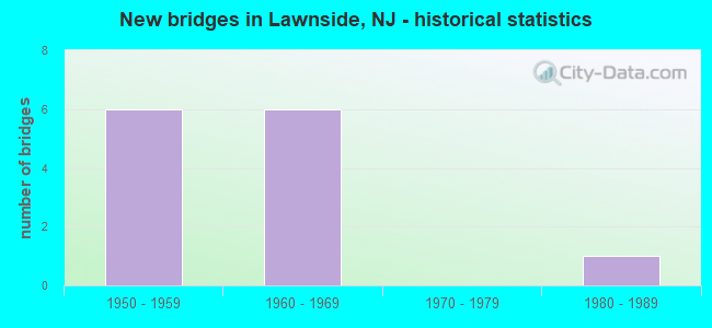
- New bridges - historical statistics
- 61950-1959
- 61960-1969
- 11980-1989


- Bridge Condition - Deck
- 37.5%Good
- 50.0%Satisfactory
- 12.5%Fair

- Bridge Condition - Superstructure
- 25.0%Good
- 50.0%Satisfactory
- 25.0%Fair

- Bridge Condition - Substructure
- 50.0%Good
- 50.0%Satisfactory
Find on map >> Show street view
Structure Number: 42915, Location: AT I-295 EXIT 30 (Lat: 39.872111, Lng: -75.037611), Route carried "on" structure: County highway 669, Year Built: 1962, Status: Open, Structure Length: 4.88m (16.01ft), Average Daily Traffic: 13,123 (year 2015), Truck Traffic: 4%, Average Future Daily Traffic: 15,747 (year 2035), Design Load: HS 20, Features Intersected: I-295, Facility Carried by Structure: WARWICK ROAD
Minimum Vertical Clearance: 30+ m (98+ ft), Kilometerpoint: 7.516, Lanes on structure: 2, Lanes under structure: 7, Owner: State Highway Agency, Approaching Roadway Width: 14.0m (45.9ft), Skew: 1 degrees, Material/Design: Prestressed concrete, Design/Construction: Stringer/Multi-beam, Number Of Spans In Main Unit: 2, Length of Maximum Span: 23.2m (76.1ft), Curb or Sidewalk Widths: Left: 1.8m (5.9ft), Right: 1.8m (5.9ft), Curb-To-Curb Width: 14.0m (45.9ft), Out-to-Out Width: 18.3m (60.0ft)
Condition: Deck: Satisfactory, Superstructure: Fair, Substructure: Good, Operating Rating: 70.8 metric tons, Method Used To Determine Operating Rating: Load Factor (LF), Inventory Rating: 39.9 metric tons, Method Used To Determine Inventory Rating: Load Factor (LF), Structural Evaluation: Somewhat better than minimum adequacy, Deck Geometry: Superior to present desirable criteria, Underclear: Equal to present minimum criteria, Approach Roadway Alignment: Better than present minimum criteria, Length Of Structure Improvement: 4.88m (16.01ft), Designated Inspection Frequency: Every 24 months, Inspection Date: September 2021, Bridge Improvement Cost: $791,000, Roadway Improvement Cost: $102,000, Total Project Cost: $870,000 ( Estimate for 2019), Deck Structure Type: Concrete Cast-file-Place, Wearing Surface/Protective System: Wearing Surface: Monolithic Concrete
Find on map >> Show street view
Structure Number: 429151, Location: 0.99 MILES NORTH OF US 30 (Lat: 39.871119, Lng: -75.032150), Route carried "on" structure: City street , Year Built: 1962, Status: Open, Structure Length: 4.51m (14.80ft), Average Daily Traffic: 368 (year 2020), Truck Traffic: 1%, Average Future Daily Traffic: 442 (year 2040), Design Load: HS 20, Features Intersected: I-295, Facility Carried by Structure: LUNDY STREET
Minimum Vertical Clearance: 30+ m (98+ ft), Kilometerpoint: 0.000, Lanes on structure: 2, Lanes under structure: 7, Owner: State Highway Agency, Approaching Roadway Width: 9.1m (29.9ft), Material/Design: Prestressed concrete, Design/Construction: Stringer/Multi-beam, Number Of Spans In Main Unit: 2, Length of Maximum Span: 21.6m (70.9ft), Curb or Sidewalk Widths: Left: 0.5m (1.6ft), Right: 1.8m (5.9ft), Curb-To-Curb Width: 9.1m (29.9ft), Out-to-Out Width: 12.0m (39.4ft)
Condition: Deck: Good, Superstructure: Good, Substructure: Good, Inventory Rating: 56.2 metric tons, Method Used To Determine Inventory Rating: Load Factor (LF), Structural Evaluation: Better than present minimum criteria, Deck Geometry: Equal to present minimum criteria, Underclear: High priority of corrective action, Approach Roadway Alignment: Somewhat better than minimum adequacy, Length Of Structure Improvement: 4.51m (14.80ft), Designated Inspection Frequency: Every 24 months, Inspection Date: July 2020, Bridge Improvement Cost: $582,000, Roadway Improvement Cost: $115,000, Total Project Cost: $882,000 ( Estimate for 2020), Deck Structure Type: Concrete Cast-file-Place, Wearing Surface/Protective System: Wearing Surface: Monolithic Concrete
Find on map >> Show street view
Structure Number: 429154, Location: 2.92 MI SOUTH OF RT 70 (Lat: 39.875669, Lng: -75.015919), Route carried "on" structure: Interstate 295, Year Built: 1962, Year Reconstructed: 1982, Status: Open, Structure Length: 4.27m (14.01ft), Average Daily Traffic: 73,300 (year 2021), Truck Traffic: 9%, Average Future Daily Traffic: 87,900 (year 2041), Design Load: HS 20, Features Intersected: PATCO Railroad
Minimum Vertical Clearance: 30+ m (98+ ft), Kilometerpoint: 51.322, Lanes on structure: 4, Base Highway Network: Yes, Owner: State Highway Agency, Approaching Roadway Width: 23.8m (78.1ft), Material/Design: Steel, Design/Construction: Stringer/Multi-beam, Number Of Spans In Main Unit: 3, Length of Maximum Span: 19.2m (63.0ft), Curb-To-Curb Width: 29.8m (97.8ft), Out-to-Out Width: 30.4m (99.7ft)
Condition: Deck: Good, Superstructure: Satisfactory, Substructure: Satisfactory, Operating Rating: 59.0 metric tons, Method Used To Determine Operating Rating: Load Factor (LF), Inventory Rating: 35.4 metric tons, Method Used To Determine Inventory Rating: Load Factor (LF), Structural Evaluation: Equal to present minimum criteria, Deck Geometry: Superior to present desirable criteria, Underclear: Meets minimum limits, Approach Roadway Alignment: Equal to present desirable criteria, Designated Inspection Frequency: Every 24 months, Inspection Date: July 2021, Deck Structure Type: Concrete Cast-file-Place, Wearing Surface/Protective System: Wearing Surface: Monolithic Concrete, Deck Protection: Epoxy Coated Reinforcing
Find on map >> Show street view
Structure Number: 45D013, Location: .54 MI. W BURNT MILL ROAD (Lat: 39.870561, Lng: -75.016281), Route carried "on" structure: County highway 667, Year Built: 1967, Status: Open, Structure Length: 1.43m (4.69ft), Average Daily Traffic: 5,687 (year 2021), Truck Traffic: 4%, Average Future Daily Traffic: 6,824 (year 2041), Design Load: HS 20, Features Intersected: SO BRANCH COOPER RIVER
Minimum Vertical Clearance: 30+ m (98+ ft), Kilometerpoint: 1.642, Lanes on structure: 2, Owner: County Highway Agency, Approaching Roadway Width: 11.0m (36.1ft), Skew: 1 degrees, Material/Design: Prestressed concrete, Design/Construction: Box Beam or Girders - Multiple, Number Of Spans In Main Unit: 1, Length of Maximum Span: 13.1m (43.0ft), Curb or Sidewalk Widths: Left: 1.6m (5.2ft), Right: 1.6m (5.2ft), Curb-To-Curb Width: 12.2m (40.0ft), Out-to-Out Width: 15.9m (52.2ft)
Condition: Deck: Satisfactory, Superstructure: Satisfactory, Substructure: Satisfactory, Channel: Satisfactory, Operating Rating: 49.9 metric tons, Method Used To Determine Operating Rating: Load Factor (LF), Inventory Rating: 30.8 metric tons, Method Used To Determine Inventory Rating: Load Factor (LF), Structural Evaluation: Equal to present minimum criteria, Deck Geometry: Somewhat better than minimum adequacy, Waterway Adequacy: Better than present minimum criteria, Approach Roadway Alignment: Equal to present desirable criteria, Designated Inspection Frequency: Every 24 months, Inspection Date: March 2021, Deck Structure Type: Concrete Cast-file-Place, Wearing Surface/Protective System: Wearing Surface: Monolithic Concrete
Find on map >> Show street view
Structure Number: 46D005, Location: 0.68 MI E OF RT 30 (Lat: 39.859261, Lng: -75.015969), Route carried "on" structure: County highway 544, Year Built: 1980, Status: Open, Structure Length: 1.01m (3.31ft), Average Daily Traffic: 10,014 (year 2021), Truck Traffic: 4%, Average Future Daily Traffic: 12,017 (year 2041), Design Load: HS 20+Mod, Features Intersected: COOPER RIVER
Minimum Vertical Clearance: 30+ m (98+ ft), Kilometerpoint: 9.560, Lanes on structure: 2, Base Highway Network: Yes, Owner: County Highway Agency, Approaching Roadway Width: 15.2m (49.9ft), Material/Design: Prestressed concrete, Design/Construction: Box Beam or Girders - Single/Spread, Number Of Spans In Main Unit: 1, Length of Maximum Span: 9.8m (32.2ft), Curb or Sidewalk Widths: Left: 1.5m (4.9ft), Right: 1.5m (4.9ft), Curb-To-Curb Width: 15.2m (49.9ft), Out-to-Out Width: 19.0m (62.3ft)
Condition: Deck: Good, Superstructure: Good, Substructure: Good, Channel: Satisfactory, Operating Rating: 68.0 metric tons, Method Used To Determine Operating Rating: Load Factor (LF), Inventory Rating: 40.8 metric tons, Method Used To Determine Inventory Rating: Load Factor (LF), Structural Evaluation: Better than present minimum criteria, Deck Geometry: Superior to present desirable criteria, Waterway Adequacy: Equal to present minimum criteria, Approach Roadway Alignment: Equal to present desirable criteria, Designated Inspection Frequency: Every 24 months, Inspection Date: March 2021, Deck Structure Type: Concrete Cast-file-Place, Wearing Surface/Protective System: Wearing Surface: Bituminous
Find on map >> Show street view
Structure Number: M02771, Location: 1.75 MI NORTH OF EXIT 3 (Lat: 39.865156, Lng: -75.042894), Route carried "on" structure: Other road NJTPK, Year Built: 1950, Status: Open, Structure Length: 6.40m (21.00ft), Average Daily Traffic: 47,832 (year 2020), Truck Traffic: 15%, Average Future Daily Traffic: 58,364 (year 2040), Design Load: HS 20, Features Intersected: PRSL RR, E. ATLANTIC AVE, Facility Carried by Structure: NJ TURNPIKE
Minimum Vertical Clearance: 30+ m (98+ ft), Kilometerpoint: 44.933, Lanes on structure: 4, Lanes under structure: 2, Base Highway Network: Yes, Toll: On toll road, Owner: State Toll Authority, Approaching Roadway Width: 29.3m (96.1ft), Skew: 31 degrees, Material/Design: Steel continuous, Design/Construction: Stringer/Multi-beam, Number Of Spans In Main Unit: 4, Length of Maximum Span: 17.4m (57.1ft), Curb or Sidewalk Widths: Left: 0.6m (2.0ft), Right: 0.6m (2.0ft), Curb-To-Curb Width: 28.7m (94.2ft), Out-to-Out Width: 30.5m (100.1ft)
Condition: Deck: Satisfactory, Superstructure: Satisfactory, Substructure: Good, Operating Rating: 34.0 metric tons, Method Used To Determine Operating Rating: Load and Resistance Factor Rating (LRFR) rating reported by rating factor(RF) method using HL-93 loadings, Inventory Rating: 26.2 metric tons, Method Used To Determine Inventory Rating: Load and Resistance Factor Rating (LRFR) rating reported by rating factor(RF) method using HL-93 loadings, Structural Evaluation: Equal to present minimum criteria, Deck Geometry: Superior to present desirable criteria, Underclear: Somewhat better than minimum adequacy, Approach Roadway Alignment: Equal to present desirable criteria, Designated Inspection Frequency: Every 24 months, Inspection Date: April 2020, Deck Structure Type: Concrete Cast-file-Place, Wearing Surface/Protective System: Wearing Surface: Bituminous, Membrane: Preformed Fabric
Find on map >> Show street view
Structure Number: M02795, Location: 2 MI NORTH OF EXIT 3 (Lat: 39.865861, Lng: -75.038583), Route carried "on" structure: Other road NJTPK, Year Built: 1950, Status: Open, Structure Length: 4.45m (14.60ft), Average Daily Traffic: 65,205 (year 2020), Truck Traffic: 11%, Average Future Daily Traffic: 79,562 (year 2040), Design Load: HS 20, Features Intersected: US 30 (WHITEHORSE PIKE), Facility Carried by Structure: NJ TURNPIKE
Minimum Vertical Clearance: 30+ m (98+ ft), Kilometerpoint: 45.319, Lanes on structure: 4, Lanes under structure: 4, Base Highway Network: Yes, Toll: On toll road, Owner: State Toll Authority, Approaching Roadway Width: 29.3m (96.1ft), Skew: 32 degrees, Material/Design: Steel, Design/Construction: Stringer/Multi-beam, Number Of Spans In Main Unit: 3, Length of Maximum Span: 25.3m (83.0ft), Curb or Sidewalk Widths: Left: 0.6m (2.0ft), Right: 0.6m (2.0ft), Curb-To-Curb Width: 28.7m (94.2ft), Out-to-Out Width: 30.5m (100.1ft)
Condition: Deck: Fair, Superstructure: Fair, Substructure: Satisfactory, Operating Rating: 33.4 metric tons, Method Used To Determine Operating Rating: Load and Resistance Factor Rating (LRFR) rating reported by rating factor(RF) method using HL-93 loadings, Inventory Rating: 25.9 metric tons, Method Used To Determine Inventory Rating: Load and Resistance Factor Rating (LRFR) rating reported by rating factor(RF) method using HL-93 loadings, Structural Evaluation: Somewhat better than minimum adequacy, Deck Geometry: Superior to present desirable criteria, Underclear: Meets minimum limits, Approach Roadway Alignment: Equal to present desirable criteria, Designated Inspection Frequency: Every 24 months, Inspection Date: March 2020, Deck Structure Type: Concrete Cast-file-Place, Wearing Surface/Protective System: Wearing Surface: Bituminous, Membrane: Epoxy
Find on map >> Show street view
Structure Number: M02819, Location: 2.2 MI NORTH OF EXIT 3 (Lat: 39.867194, Lng: -75.034283), Route carried "on" structure: County highway 669, Year Built: 1950, Status: Open, Structure Length: 5.39m (17.68ft), Average Daily Traffic: 17,977 (year 2020), Truck Traffic: 4%, Average Future Daily Traffic: 21,573 (year 2040), Design Load: H 20, Features Intersected: NJ TURNPIKE, Facility Carried by Structure: WARWICK RD
Minimum Vertical Clearance: 30+ m (98+ ft), Kilometerpoint: 6.856, Lanes on structure: 2, Lanes under structure: 4, Owner: State Toll Authority, Approaching Roadway Width: 9.1m (29.9ft), Skew: 2 degrees, Material/Design: Steel continuous, Design/Construction: Stringer/Multi-beam, Number Of Spans In Main Unit: 4, Length of Maximum Span: 16.8m (55.1ft), Curb or Sidewalk Widths: Left: 1.5m (4.9ft), Right: 1.5m (4.9ft), Curb-To-Curb Width: 9.1m (29.9ft), Out-to-Out Width: 12.8m (42.0ft)
Condition: Deck: Satisfactory, Superstructure: Satisfactory, Substructure: Satisfactory, Operating Rating: 23.3 metric tons, Method Used To Determine Operating Rating: Load and Resistance Factor Rating (LRFR) rating reported by rating factor(RF) method using HL-93 loadings, Inventory Rating: 17.8 metric tons, Method Used To Determine Inventory Rating: Load and Resistance Factor Rating (LRFR) rating reported by rating factor(RF) method using HL-93 loadings, Structural Evaluation: Meets minimum limits, Deck Geometry: High priority of corrective action, Underclear: High priority of corrective action, Approach Roadway Alignment: Equal to present desirable criteria, Length Of Structure Improvement: 5.39m (17.68ft), Designated Inspection Frequency: Every 24 months, Inspection Date: March 2020, Bridge Improvement Cost: $165,000, Roadway Improvement Cost: $35,000, Total Project Cost: $276,000 ( Estimate for 2016), Deck Structure Type: Concrete Cast-file-Place, Wearing Surface/Protective System: Wearing Surface: Monolithic Concrete
Find on map >> Show street view
Structure Number: 42915, Location: AT I-295 EXIT 30 (Lat: 39.872111, Lng: -75.037611), Route carried "under" structure: County highway 669, Year Built: 1962, Structure Length: 0. m, Average Daily Traffic: 13,653 (year 2019), Truck Traffic: 4%, Features Intersected: I-295, Facility Carried by Structure: WARWICK ROAD
Minimum Vertical Clearance: 30+ m (98+ ft), Kilometerpoint: 7.516, Lanes on structure: 2, Lanes under structure: 2, Material/Design: Prestressed concrete, Design/Construction: Stringer/Multi-beam, Length of Maximum Span: 23.2m (76.1ft)
Find on map >> Show street view
Structure Number: 429151, Location: 0.99 MILES NORTH OF US 30 (Lat: 39.871119, Lng: -75.032150), Route carried "under" structure: Interstate 295, Year Built: 1962, Structure Length: 0. m, Average Daily Traffic: 140,430 (year 2020), Truck Traffic: 9%, Features Intersected: I-295, Facility Carried by Structure: LUNDY STREET
Minimum Vertical Clearance: 4.62m (15.16ft), Kilometerpoint: 49.793, Lanes on structure: 2, Lanes under structure: 7, Material/Design: Prestressed concrete, Design/Construction: Stringer/Multi-beam, Length of Maximum Span: 21.6m (70.9ft)
Find on map >> Show street view
Structure Number: M02771, Location: 1.75 MI NORTH OF EXIT 3 (Lat: 39.865156, Lng: -75.042894), Route carried "under" structure: County highway 727, Year Built: 1950, Structure Length: 0. m, Average Daily Traffic: 3,294 (year 2020), Truck Traffic: 3%, Features Intersected: PRSL RR, E. ATLANTIC AVE, Facility Carried by Structure: NJ TURNPIKE
Minimum Vertical Clearance: 7.80m (25.59ft), Kilometerpoint: 8.175, Lanes on structure: 4, Lanes under structure: 2, Material/Design: Steel continuous, Design/Construction: Stringer/Multi-beam, Length of Maximum Span: 17.4m (57.1ft)
Find on map >> Show street view
Structure Number: M02795, Location: 2 MI NORTH OF EXIT 3 (Lat: 39.865861, Lng: -75.038583), Route carried "under" structure: US 30, Year Built: 1950, Structure Length: 0. m, Average Daily Traffic: 41,246 (year 2020), Truck Traffic: 4%, Features Intersected: US 30 (WHITEHORSE PIKE), Facility Carried by Structure: NJ TURNPIKE
Minimum Vertical Clearance: 4.93m (16.17ft), Kilometerpoint: 14.211, Lanes on structure: 4, Lanes under structure: 4, Material/Design: Steel, Design/Construction: Stringer/Multi-beam, Length of Maximum Span: 25.3m (83.0ft)
Find on map >> Show street view
Structure Number: M02819, Location: 2.2 MI NORTH OF EXIT 3 (Lat: 39.867194, Lng: -75.034283), Route carried "under" structure: Other road NJTPK, Year Built: 1950, Structure Length: 0. m, Average Daily Traffic: 65,204 (year 2020), Truck Traffic: 16%, Features Intersected: NJ TURNPIKE, Facility Carried by Structure: WARWICK RD
Minimum Vertical Clearance: 4.55m (14.93ft), Kilometerpoint: 45.609, Lanes on structure: 2, Lanes under structure: 4, Toll: On toll road, Material/Design: Steel continuous, Design/Construction: Stringer/Multi-beam, Length of Maximum Span: 16.8m (55.1ft)