Bridge Statistics for Lawrenceburg, Kentucky (KY)
Condition, Traffic, Stress, Structural Evaluation, Project Costs
- National Bridge Inventory (NBI) Statistics
- 37Number of bridges
- 423ft / 129mTotal length
- $8,696,000Total costs
- 105,836Total average daily traffic
- 14,947Total average daily truck traffic
- National Bridge Inventory (NBI) Registered Bridges for Lawrenceburg
- No street view available for this location
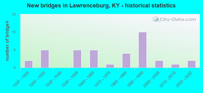
- New bridges - historical statistics
- 21920-1929
- 51930-1939
- 51950-1959
- 51960-1969
- 11970-1979
- 41980-1989
- 101990-1999
- 22000-2009
- 12010-2019
- 22020-2022

- Reconstructed bridges - Historical Statistics
- 12000-2009
- 12010-2019


- Bridge Condition - Deck
- 11.5%Very good
- 46.2%Good
- 38.5%Satisfactory
- 3.8%Fair

- Bridge Condition - Superstructure
- 15.4%Very good
- 42.3%Good
- 23.1%Satisfactory
- 19.2%Fair

- Bridge Condition - Substructure
- 11.5%Very good
- 30.8%Good
- 46.2%Satisfactory
- 11.5%Fair

- Bridge Condition - Channel
- 3.8%Very good
- 38.5%Good
- 42.3%Satisfactory
- 11.5%Fair
- 3.8%Poor

- Bridge Condition - Culverts
- 28.6%Satisfactory
- 71.4%Fair
Find on map >> Show street view
Structure Number: 3B00003N, Location: @WOODFORD CO.LN. (Lat: 38.040833, Lng: -84.846667), Route carried "on" structure: US 62, Year Built: 1932, Year Reconstructed: 2007, Status: Posted for load, Structure Length: 38.95m (127.79ft), Average Daily Traffic: 3,645 (year 2020), Truck Traffic: 9%, Average Future Daily Traffic: 3,207 (year 2040), Design Load: H 15, Features Intersected: KENTUCKY RIVER
Minimum Vertical Clearance: 30+ m (98+ ft), Kilometerpoint: 36.728, Lanes on structure: 2, Owner: State Highway Agency, Approaching Roadway Width: 6.7m (22.0ft), Material/Design: Steel, Design/Construction: Truss - Deck, Number Of Spans In Main Unit: 3, Number Of Approach Spans: 9, Length of Maximum Span: 109.1m (357.9ft), Curb or Sidewalk Widths: Left: 0.2m (0.7ft), Right: 0.2m (0.7ft), Curb-To-Curb Width: 7.4m (24.3ft), Out-to-Out Width: 8.3m (27.2ft)
Condition: Deck: Satisfactory, Superstructure: Fair, Substructure: Satisfactory, Channel: Good, Operating Rating: 37.3 metric tons, Method Used To Determine Operating Rating: Load Factor (LF), Inventory Rating: 22.4 metric tons, Method Used To Determine Inventory Rating: Load Factor (LF), Structural Evaluation: Somewhat better than minimum adequacy, Deck Geometry: High priority of replacement, Waterway Adequacy: Superior to present desirable criteria, Approach Roadway Alignment: High priority of corrective action, Bridge Posting: Required (Relationship of Operating Rating to Maximum Legal Load: > 39.9% below), Length Of Structure Improvement: 3.83m (12.57ft), Designated Inspection Frequency: Every 24 months, Critical Feature Inspection Frequency: Every 24 months, Inspection Date: August 2021, Critical Feature Inspection Date: August 2021, Bridge Improvement Cost: $4,782,000, Total Project Cost: $4,781,000, Deck Structure Type: Concrete Cast-file-Place, Wearing Surface/Protective System: Wearing Surface: Monolithic Concrete
Find on map >> Show street view
Structure Number: 3B00006N, Location: 1 MI W OF WOODFORD CO.LN. (Lat: 37.987500, Lng: -84.843611), Route carried "on" structure: State highway 9002, Year Built: 1965, Status: Open, Structure Length: 0.63m (2.07ft), Average Daily Traffic: 13,483 (year 2020), Truck Traffic: 26%, Average Future Daily Traffic: 12,674 (year 2040), Design Load: H 20, Features Intersected: WISE RD
Minimum Vertical Clearance: 30+ m (98+ ft), Kilometerpoint: 97.863, Lanes on structure: 4, Lanes under structure: 2, Base Highway Network: Yes, Owner: State Highway Agency, Approaching Roadway Width: 11.0m (36.1ft), Skew: 21 degrees, Material/Design: Concrete, Design/Construction: Culvert, Number Of Spans In Main Unit: 1, Length of Maximum Span: 6.3m (20.7ft)
Condition: Culverts: Satisfactory, Operating Rating: 89.8 metric tons, Method Used To Determine Operating Rating: Load Factor (LF), Inventory Rating: 62.1 metric tons, Method Used To Determine Inventory Rating: Load Factor (LF), Structural Evaluation: Equal to present minimum criteria, Underclear: High priority of corrective action, Approach Roadway Alignment: Better than present minimum criteria, Length Of Structure Improvement: 0.07m (0.23ft), Designated Inspection Frequency: Every 24 months, Inspection Date: June 2020, Bridge Improvement Cost: $58,000, Total Project Cost: $57,000
Find on map >> Show street view
Structure Number: 3B00009L, Location: 1.5 MI N BG-PARKWAY (Lat: 37.990556, Lng: -84.889444), Route carried "on" structure: Bypass US 127, Year Built: 1965, Status: Open, Structure Length: 5.85m (19.19ft), Average Daily Traffic: 6,809 (year 2020), Truck Traffic: 15%, Average Future Daily Traffic: 6,400 (year 2040), Design Load: HS 20, Features Intersected: NS (CNO&TP) SYSTEM
Minimum Vertical Clearance: 30+ m (98+ ft), Kilometerpoint: 1.458, Lanes on structure: 2, Base Highway Network: Yes, Owner: State Highway Agency, Approaching Roadway Width: 11.6m (38.1ft), Skew: 3 degrees, Material/Design: Concrete continuous, Design/Construction: Tee Beam, Number Of Spans In Main Unit: 3, Length of Maximum Span: 23.5m (77.1ft), Curb or Sidewalk Widths: Left: 0.5m (1.6ft), Right: 0.5m (1.6ft), Curb-To-Curb Width: 9.2m (30.2ft), Out-to-Out Width: 10.1m (33.1ft)
Condition: Deck: Good, Superstructure: Satisfactory, Substructure: Satisfactory, Operating Rating: 58.0 metric tons, Method Used To Determine Operating Rating: Load Factor (LF), Inventory Rating: 34.7 metric tons, Method Used To Determine Inventory Rating: Load Factor (LF), Structural Evaluation: Equal to present minimum criteria, Deck Geometry: Meets minimum limits, Underclear: Meets minimum limits, Approach Roadway Alignment: Equal to present desirable criteria, Designated Inspection Frequency: Every 24 months, Inspection Date: June 2020, Deck Structure Type: Concrete Cast-file-Place, Wearing Surface/Protective System: Wearing Surface: Latex Concrete
Find on map >> Show street view
Structure Number: 3B00010L, Location: .5 MI S JCT KY 151 (Lat: 38.061944, Lng: -84.921111), Route carried "on" structure: Bypass US 127, Year Built: 1966, Status: Posted for load, Structure Length: 7.32m (24.02ft), Average Daily Traffic: 10,237 (year 2019), Truck Traffic: 15%, Average Future Daily Traffic: 9,623 (year 2039), Design Load: HS 20, Features Intersected: NS (CNO&TP) SYSTEM
Minimum Vertical Clearance: 30+ m (98+ ft), Kilometerpoint: 9.997, Lanes on structure: 2, Base Highway Network: Yes, Owner: State Highway Agency, Approaching Roadway Width: 11.6m (38.1ft), Skew: 4 degrees, Material/Design: Concrete continuous, Design/Construction: Tee Beam, Number Of Spans In Main Unit: 3, Length of Maximum Span: 27.2m (89.2ft), Curb or Sidewalk Widths: Left: 0.5m (1.6ft), Right: 0.5m (1.6ft), Curb-To-Curb Width: 9.2m (30.2ft), Out-to-Out Width: 10.7m (35.1ft)
Condition: Deck: Good, Superstructure: Good, Substructure: Fair, Operating Rating: 48.8 metric tons, Method Used To Determine Operating Rating: Load Factor (LF), Inventory Rating: 29.3 metric tons, Method Used To Determine Inventory Rating: Load Factor (LF), Structural Evaluation: Somewhat better than minimum adequacy, Deck Geometry: Meets minimum limits, Underclear: Meets minimum limits, Approach Roadway Alignment: Better than present minimum criteria, Bridge Posting: Required (Relationship of Operating Rating to Maximum Legal Load: 20.0 - 29.9% below), Designated Inspection Frequency: Every 24 months, Inspection Date: June 2020, Deck Structure Type: Concrete Cast-file-Place, Wearing Surface/Protective System: Wearing Surface: Latex Concrete
Find on map >> Show street view
Structure Number: 3B00011N, Location: .55 MI E OF JCT KY 513 (Lat: 37.997778, Lng: -84.959444), Route carried "on" structure: US 62, Year Built: 1930, Status: Open, Structure Length: 6.55m (21.49ft), Average Daily Traffic: 2,814 (year 2020), Truck Traffic: 8%, Average Future Daily Traffic: 2,476 (year 2040), Design Load: H 15, Features Intersected: SALT RIVER
Minimum Vertical Clearance: 30+ m (98+ ft), Kilometerpoint: 24.158, Lanes on structure: 2, Owner: State Highway Agency, Approaching Roadway Width: 6.9m (22.6ft), Material/Design: Concrete, Design/Construction: Tee Beam, Number Of Spans In Main Unit: 5, Length of Maximum Span: 12.4m (40.7ft), Curb or Sidewalk Widths: Left: 0.5m (1.6ft), Right: 0.5m (1.6ft), Curb-To-Curb Width: 7.1m (23.3ft), Out-to-Out Width: 8.0m (26.2ft)
Condition: Deck: Satisfactory, Superstructure: Fair, Substructure: Satisfactory, Channel: Fair, Operating Rating: 60.4 metric tons, Method Used To Determine Operating Rating: Load Factor (LF), Inventory Rating: 36.3 metric tons, Method Used To Determine Inventory Rating: Load Factor (LF), Structural Evaluation: Somewhat better than minimum adequacy, Deck Geometry: High priority of replacement, Waterway Adequacy: Better than present minimum criteria, Approach Roadway Alignment: Somewhat better than minimum adequacy, Length Of Structure Improvement: 0.68m (2.23ft), Designated Inspection Frequency: Every 24 months, Inspection Date: June 2020, Bridge Improvement Cost: $724,000, Total Project Cost: $724,000, Deck Structure Type: Concrete Cast-file-Place, Wearing Surface/Protective System: Wearing Surface: Latex Concrete
Find on map >> Show street view
Structure Number: 3B00012N, Location: .3 MI W OF JCT KY 513 (Lat: 37.986944, Lng: -84.968611), Route carried "on" structure: US 62, Year Built: 1930, Status: Posted for load, Structure Length: 0.90m (2.95ft), Average Daily Traffic: 2,368 (year 2018), Truck Traffic: 8%, Average Future Daily Traffic: 2,083 (year 2038), Design Load: H 15, Features Intersected: FORK OF FOX CREEK
Minimum Vertical Clearance: 30+ m (98+ ft), Kilometerpoint: 22.684, Lanes on structure: 2, Owner: State Highway Agency, Approaching Roadway Width: 7.0m (23.0ft), Skew: 4 degrees, Material/Design: Concrete, Design/Construction: Culvert, Number Of Spans In Main Unit: 2, Length of Maximum Span: 4.4m (14.4ft)
Condition: Channel: Good, Culverts: Fair, Operating Rating: 39.0 metric tons, Method Used To Determine Operating Rating: Field evaluation and documented engineering judgment, Inventory Rating: 18.1 metric tons, Method Used To Determine Inventory Rating: Field evaluation and documented engineering judgment, Structural Evaluation: Somewhat better than minimum adequacy, Waterway Adequacy: Better than present minimum criteria, Approach Roadway Alignment: Somewhat better than minimum adequacy, Bridge Posting: Required (Relationship of Operating Rating to Maximum Legal Load: > 39.9% below), Designated Inspection Frequency: Every 24 months, Inspection Date: June 2020
Find on map >> Show street view
Structure Number: 3B00039N, Location: 1.3 MI S OF JCT US 62 (Lat: 38.034444, Lng: -84.837778), Route carried "on" structure: State highway 1510, Year Built: 1963, Status: Posted for load, Structure Length: 6.19m (20.31ft), Average Daily Traffic: 757 (year 2020), Average Future Daily Traffic: 658 (year 2040), Design Load: H 15, Features Intersected: CEDAR BROOK
Minimum Vertical Clearance: 30+ m (98+ ft), Kilometerpoint: 0.726, Lanes on structure: 2, Owner: State Highway Agency, Approaching Roadway Width: 6.1m (20.0ft), Skew: 4 degrees, Material/Design: Concrete continuous, Design/Construction: Tee Beam, Number Of Spans In Main Unit: 3, Length of Maximum Span: 25.6m (84.0ft), Curb or Sidewalk Widths: Left: 0.8m (2.6ft), Right: 0.0m, Curb-To-Curb Width: 7.3m (24.0ft), Out-to-Out Width: 9.4m (30.8ft)
Condition: Deck: Fair, Superstructure: Satisfactory, Substructure: Satisfactory, Channel: Fair, Operating Rating: 29.5 metric tons, Method Used To Determine Operating Rating: Load Factor (LF), Inventory Rating: 17.7 metric tons, Method Used To Determine Inventory Rating: Load Factor (LF), Structural Evaluation: Meets minimum limits, Deck Geometry: Meets minimum limits, Waterway Adequacy: Equal to present desirable criteria, Approach Roadway Alignment: Equal to present minimum criteria, Bridge Posting: Required (Relationship of Operating Rating to Maximum Legal Load: > 39.9% below), Designated Inspection Frequency: Every 24 months, Inspection Date: June 2020, Deck Structure Type: Concrete Cast-file-Place, Wearing Surface/Protective System: Wearing Surface: Latex Concrete
Find on map >> Show street view
Structure Number: 3B00042N, Location: 10 FT S -JCT. US 62 (Lat: 37.998333, Lng: -84.958611), Route carried "on" structure: State highway 2920, Year Built: 1928, Status: Posted for load, Structure Length: 1.16m (3.81ft), Average Daily Traffic: 9 (year 2019), Average Future Daily Traffic: 7 (year 2039), Design Load: H 15, Features Intersected: MIDDLETON CREEK
Minimum Vertical Clearance: 30+ m (98+ ft), Kilometerpoint: 0.013, Lanes on structure: 2, Owner: State Highway Agency, Approaching Roadway Width: 4.7m (15.4ft), Material/Design: Concrete, Design/Construction: Tee Beam, Number Of Spans In Main Unit: 1, Length of Maximum Span: 10.7m (35.1ft), Curb or Sidewalk Widths: Left: 0.1m (0.3ft), Right: 0.1m (0.3ft), Curb-To-Curb Width: 4.9m (16.1ft), Out-to-Out Width: 5.8m (19.0ft)
Condition: Deck: Good, Superstructure: Fair, Substructure: Satisfactory, Channel: Satisfactory, Operating Rating: 46.9 metric tons, Method Used To Determine Operating Rating: Load Factor (LF), Inventory Rating: 28.1 metric tons, Method Used To Determine Inventory Rating: Load Factor (LF), Structural Evaluation: Somewhat better than minimum adequacy, Deck Geometry: High priority of corrective action, Waterway Adequacy: Better than present minimum criteria, Approach Roadway Alignment: High priority of replacement, Bridge Posting: Required (Relationship of Operating Rating to Maximum Legal Load: 20.0 - 29.9% below), Length Of Structure Improvement: 0.12m (0.39ft), Designated Inspection Frequency: Every 24 months, Inspection Date: June 2020, Bridge Improvement Cost: $90,000, Total Project Cost: $90,000, Deck Structure Type: Concrete Cast-file-Place, Wearing Surface/Protective System: Wearing Surface: Monolithic Concrete
Find on map >> Show street view
Structure Number: 3B00045N, Location: 1.3 MI W OF JCT US 127 (Lat: 37.973611, Lng: -84.900278), Route carried "on" structure: State highway 513, Year Built: 1983, Status: Open, Structure Length: 3.35m (10.99ft), Average Daily Traffic: 1,113 (year 2019), Average Future Daily Traffic: 979 (year 2039), Design Load: HS 20, Features Intersected: SALT RIVER
Minimum Vertical Clearance: 30+ m (98+ ft), Kilometerpoint: 6.717, Lanes on structure: 2, Owner: State Highway Agency, Approaching Roadway Width: 6.7m (22.0ft), Material/Design: Prestressed concrete, Design/Construction: Box Beam or Girders - Multiple, Number Of Spans In Main Unit: 2, Length of Maximum Span: 15.5m (50.9ft), Curb-To-Curb Width: 6.6m (21.7ft), Out-to-Out Width: 7.6m (24.9ft)
Condition: Deck: Satisfactory, Superstructure: Satisfactory, Substructure: Fair, Channel: Satisfactory, Operating Rating: 76.9 metric tons, Method Used To Determine Operating Rating: Load Factor (LF), Inventory Rating: 46.2 metric tons, Method Used To Determine Inventory Rating: Load Factor (LF), Structural Evaluation: Somewhat better than minimum adequacy, Deck Geometry: High priority of replacement, Waterway Adequacy: Equal to present desirable criteria, Approach Roadway Alignment: Somewhat better than minimum adequacy, Length Of Structure Improvement: 0.34m (1.12ft), Designated Inspection Frequency: Every 24 months, Inspection Date: June 2020, Bridge Improvement Cost: $340,000, Total Project Cost: $339,000, Deck Structure Type: Concrete Precast Panels, Wearing Surface/Protective System: Wearing Surface: Bituminous
Find on map >> Show street view
Structure Number: 3B00048N, Location: 2.4 MI WEST OF JCT KY 513 (Lat: 37.961389, Lng: -84.931389), Route carried "on" structure: State highway 749, Year Built: 1950, Status: Posted for load, Structure Length: 0.93m (3.05ft), Average Daily Traffic: 217 (year 2018), Average Future Daily Traffic: 190 (year 2038), Features Intersected: HICKORY NUT CREEK
Minimum Vertical Clearance: 30+ m (98+ ft), Kilometerpoint: 9.259, Lanes on structure: 2, Owner: State Highway Agency, Approaching Roadway Width: 6.1m (20.0ft), Skew: 3 degrees, Material/Design: Concrete, Design/Construction: Culvert, Number Of Spans In Main Unit: 2, Length of Maximum Span: 4.1m (13.5ft)
Condition: Channel: Satisfactory, Culverts: Fair, Operating Rating: 20.0 metric tons, Method Used To Determine Operating Rating: Field evaluation and documented engineering judgment, Inventory Rating: 20.0 metric tons, Method Used To Determine Inventory Rating: Field evaluation and documented engineering judgment, Structural Evaluation: Somewhat better than minimum adequacy, Waterway Adequacy: Better than present minimum criteria, Approach Roadway Alignment: Equal to present minimum criteria, Bridge Posting: Required (Relationship of Operating Rating to Maximum Legal Load: > 39.9% below), Designated Inspection Frequency: Every 24 months, Inspection Date: June 2020
Find on map >> Show street view
Structure Number: 3B00049N, Location: 2.0 MI WEST OF JCT KY 513 (Lat: 37.960556, Lng: -84.924444), Route carried "on" structure: State highway 749, Year Built: 1950, Status: Open, Structure Length: 0.67m (2.20ft), Average Daily Traffic: 217 (year 2018), Average Future Daily Traffic: 190 (year 2038), Features Intersected: HICKORY NUT CREEK
Minimum Vertical Clearance: 30+ m (98+ ft), Kilometerpoint: 9.889, Lanes on structure: 2, Owner: State Highway Agency, Approaching Roadway Width: 6.1m (20.0ft), Material/Design: Concrete, Design/Construction: Culvert, Number Of Spans In Main Unit: 2, Length of Maximum Span: 3.1m (10.2ft)
Condition: Channel: Satisfactory, Culverts: Fair, Operating Rating: 54.4 metric tons, Method Used To Determine Operating Rating: Field evaluation and documented engineering judgment, Inventory Rating: 39.9 metric tons, Method Used To Determine Inventory Rating: Field evaluation and documented engineering judgment, Structural Evaluation: Somewhat better than minimum adequacy, Waterway Adequacy: Somewhat better than minimum adequacy, Approach Roadway Alignment: Equal to present minimum criteria, Designated Inspection Frequency: Every 24 months, Inspection Date: June 2020
Find on map >> Show street view
Structure Number: 3B00050N, Location: 1.3 MI WEST OF JCT KY 513 (Lat: 37.964722, Lng: -84.913611), Route carried "on" structure: State highway 749, Year Built: 1950, Status: Posted for load, Structure Length: 0.66m (2.17ft), Average Daily Traffic: 611 (year 2019), Average Future Daily Traffic: 537 (year 2039), Features Intersected: BR OF HICKORY NUT CREEK
Minimum Vertical Clearance: 30+ m (98+ ft), Kilometerpoint: 11.047, Lanes on structure: 2, Owner: State Highway Agency, Approaching Roadway Width: 6.1m (20.0ft), Skew: 1 degrees, Material/Design: Concrete, Design/Construction: Culvert, Number Of Spans In Main Unit: 2, Length of Maximum Span: 3.0m (9.8ft)
Condition: Channel: Fair, Culverts: Fair, Operating Rating: 20.0 metric tons, Method Used To Determine Operating Rating: Field evaluation and documented engineering judgment, Inventory Rating: 20.0 metric tons, Method Used To Determine Inventory Rating: Field evaluation and documented engineering judgment, Structural Evaluation: Somewhat better than minimum adequacy, Waterway Adequacy: Equal to present minimum criteria, Approach Roadway Alignment: Equal to present minimum criteria, Bridge Posting: Required (Relationship of Operating Rating to Maximum Legal Load: > 39.9% below), Designated Inspection Frequency: Every 24 months, Inspection Date: June 2020
Find on map >> Show street view
Structure Number: 3B00052N, Location: .50 MI N OF JCT US 127 (Lat: 38.069444, Lng: -84.905278), Route carried "on" structure: State highway 326, Year Built: 1977, Status: Open, Structure Length: 1.13m (3.71ft), Average Daily Traffic: 652 (year 2020), Average Future Daily Traffic: 612 (year 2040), Design Load: HS 20, Features Intersected: HAMMOND CREEK
Minimum Vertical Clearance: 30+ m (98+ ft), Kilometerpoint: 1.151, Lanes on structure: 2, Owner: State Highway Agency, Approaching Roadway Width: 7.0m (23.0ft), Skew: 1 degrees, Material/Design: Concrete, Design/Construction: Tee Beam, Number Of Spans In Main Unit: 1, Length of Maximum Span: 10.3m (33.8ft), Curb-To-Curb Width: 9.2m (30.2ft), Out-to-Out Width: 10.1m (33.1ft)
Condition: Deck: Good, Superstructure: Good, Substructure: Satisfactory, Channel: Good, Operating Rating: 63.3 metric tons, Method Used To Determine Operating Rating: Load Factor (LF), Inventory Rating: 38.0 metric tons, Method Used To Determine Inventory Rating: Load Factor (LF), Structural Evaluation: Equal to present minimum criteria, Deck Geometry: Equal to present minimum criteria, Waterway Adequacy: Equal to present desirable criteria, Approach Roadway Alignment: Equal to present minimum criteria, Designated Inspection Frequency: Every 24 months, Inspection Date: June 2020, Deck Structure Type: Concrete Cast-file-Place, Wearing Surface/Protective System: Wearing Surface: Monolithic Concrete
Find on map >> Show street view
Structure Number: 3B00053R, Location: 1.5 MI N JCT BG-PARKWAY (Lat: 37.990833, Lng: -84.889444), Route carried "on" structure: Bypass US 127, Year Built: 1991, Status: Open, Structure Length: 6.64m (21.78ft), Average Daily Traffic: 6,809 (year 2020), Truck Traffic: 15%, Average Future Daily Traffic: 6,400 (year 2040), Design Load: HS 25 or greater, Features Intersected: NS (CNO&TP) SYSTEM
Minimum Vertical Clearance: 30+ m (98+ ft), Kilometerpoint: 1.476, Lanes on structure: 2, Base Highway Network: Yes, Owner: State Highway Agency, Approaching Roadway Width: 13.0m (42.7ft), Skew: 3 degrees, Material/Design: Prestressed concrete continuous, Design/Construction: Stringer/Multi-beam, Number Of Spans In Main Unit: 3, Length of Maximum Span: 28.7m (94.2ft), Curb-To-Curb Width: 13.0m (42.7ft), Out-to-Out Width: 13.8m (45.3ft)
Condition: Deck: Satisfactory, Superstructure: Good, Substructure: Good, Operating Rating: 80.3 metric tons, Method Used To Determine Operating Rating: Load Factor (LF), Inventory Rating: 48.2 metric tons, Method Used To Determine Inventory Rating: Load Factor (LF), Structural Evaluation: Better than present minimum criteria, Deck Geometry: Superior to present desirable criteria, Underclear: Meets minimum limits, Approach Roadway Alignment: Better than present minimum criteria, Designated Inspection Frequency: Every 24 months, Inspection Date: June 2020, Bridge Improvement Cost: $1,911,000, Total Project Cost: $1,911,000, Deck Structure Type: Concrete Cast-file-Place, Wearing Surface/Protective System: Wearing Surface: Monolithic Concrete, Deck Protection: Epoxy Coated Reinforcing
Find on map >> Show street view
Structure Number: 3B00054R, Location: .5 MI S OF JCT KY 151 (Lat: 38.061667, Lng: -84.920833), Route carried "on" structure: Bypass US 127, Year Built: 1991, Status: Open, Structure Length: 6.64m (21.78ft), Average Daily Traffic: 10,237 (year 2019), Truck Traffic: 15%, Average Future Daily Traffic: 9,623 (year 2039), Design Load: HS 25 or greater, Features Intersected: NS (CNO&TP) SYSTEM
Minimum Vertical Clearance: 30+ m (98+ ft), Kilometerpoint: 10.007, Lanes on structure: 2, Base Highway Network: Yes, Owner: State Highway Agency, Approaching Roadway Width: 12.8m (42.0ft), Skew: 4 degrees, Material/Design: Prestressed concrete continuous, Design/Construction: Stringer/Multi-beam, Number Of Spans In Main Unit: 3, Length of Maximum Span: 27.4m (89.9ft), Curb-To-Curb Width: 12.8m (42.0ft), Out-to-Out Width: 13.8m (45.3ft)
Condition: Deck: Satisfactory, Superstructure: Good, Substructure: Satisfactory, Operating Rating: 69.6 metric tons, Method Used To Determine Operating Rating: Load Factor (LF), Inventory Rating: 41.7 metric tons, Method Used To Determine Inventory Rating: Load Factor (LF), Structural Evaluation: Equal to present minimum criteria, Deck Geometry: Equal to present desirable criteria, Underclear: Meets minimum limits, Approach Roadway Alignment: Better than present minimum criteria, Designated Inspection Frequency: Every 24 months, Inspection Date: June 2020, Deck Structure Type: Concrete Cast-file-Place, Wearing Surface/Protective System: Wearing Surface: Monolithic Concrete, Deck Protection: Epoxy Coated Reinforcing
Find on map >> Show street view
Structure Number: 3B00056N, Location: 3.0 MI W. JCT US 127 (Lat: 38.021389, Lng: -84.962778), Route carried "on" structure: State highway 44, Year Built: 1995, Status: Open, Structure Length: 8.05m (26.41ft), Average Daily Traffic: 1,172 (year 2020), Truck Traffic: 7%, Average Future Daily Traffic: 1,031 (year 2040), Design Load: HS 25 or greater, Features Intersected: HAMMOND CREEK
Minimum Vertical Clearance: 30+ m (98+ ft), Kilometerpoint: 16.134, Lanes on structure: 2, Owner: State Highway Agency, Approaching Roadway Width: 7.3m (24.0ft), Skew: 4 degrees, Material/Design: Prestressed concrete continuous, Design/Construction: Stringer/Multi-beam, Number Of Spans In Main Unit: 4, Length of Maximum Span: 18.3m (60.0ft), Curb-To-Curb Width: 8.5m (27.9ft), Out-to-Out Width: 9.6m (31.5ft)
Condition: Deck: Good, Superstructure: Good, Substructure: Satisfactory, Channel: Good, Operating Rating: 72.8 metric tons, Method Used To Determine Operating Rating: Load Factor (LF), Inventory Rating: 43.6 metric tons, Method Used To Determine Inventory Rating: Load Factor (LF), Structural Evaluation: Equal to present minimum criteria, Deck Geometry: Somewhat better than minimum adequacy, Waterway Adequacy: Equal to present minimum criteria, Approach Roadway Alignment: Better than present minimum criteria, Designated Inspection Frequency: Every 24 months, Inspection Date: June 2020, Deck Structure Type: Concrete Cast-file-Place, Wearing Surface/Protective System: Wearing Surface: Monolithic Concrete, Deck Protection: Epoxy Coated Reinforcing
Find on map >> Show street view
Structure Number: 3B00057N, Location: .9 MI W. JCT KY 513 (Lat: 37.979444, Lng: -84.972222), Route carried "on" structure: US 62, Year Built: 1996, Status: Open, Structure Length: 2.07m (6.79ft), Average Daily Traffic: 2,368 (year 2018), Truck Traffic: 8%, Average Future Daily Traffic: 2,083 (year 2038), Design Load: HS 25 or greater, Features Intersected: FOX CREEK
Minimum Vertical Clearance: 30+ m (98+ ft), Kilometerpoint: 21.768, Lanes on structure: 2, Owner: State Highway Agency, Approaching Roadway Width: 9.8m (32.2ft), Skew: 3 degrees, Material/Design: Prestressed concrete, Design/Construction: Stringer/Multi-beam, Number Of Spans In Main Unit: 1, Length of Maximum Span: 19.0m (62.3ft), Curb-To-Curb Width: 9.9m (32.5ft), Out-to-Out Width: 10.8m (35.4ft)
Condition: Deck: Good, Superstructure: Very good, Substructure: Good, Channel: Satisfactory, Operating Rating: 82.1 metric tons, Method Used To Determine Operating Rating: Load Factor (LF), Inventory Rating: 49.3 metric tons, Method Used To Determine Inventory Rating: Load Factor (LF), Structural Evaluation: Better than present minimum criteria, Deck Geometry: Meets minimum limits, Waterway Adequacy: Better than present minimum criteria, Approach Roadway Alignment: Better than present minimum criteria, Designated Inspection Frequency: Every 24 months, Inspection Date: June 2020, Deck Structure Type: Concrete Cast-file-Place, Wearing Surface/Protective System: Wearing Surface: Monolithic Concrete, Deck Protection: Epoxy Coated Reinforcing
Find on map >> Show street view
Structure Number: 3B00060N, Location: 0.3 MI. South of 513 (Lat: 37.973056, Lng: -84.875000), Route carried "on" structure: US 127, Year Built: 2003, Status: Open, Structure Length: 7.86m (25.79ft), Average Daily Traffic: 13,134 (year 2020), Truck Traffic: 12%, Average Future Daily Traffic: 12,345 (year 2040), Design Load: HS 25 or greater, Features Intersected: BG PARKWAY
Minimum Vertical Clearance: 30+ m (98+ ft), Kilometerpoint: 3.170, Lanes on structure: 4, Lanes under structure: 4, Base Highway Network: Yes, Owner: State Highway Agency, Approaching Roadway Width: 31.2m (102.4ft), Skew: 30 degrees, Material/Design: Prestressed concrete continuous, Design/Construction: Stringer/Multi-beam, Number Of Spans In Main Unit: 4, Length of Maximum Span: 25.7m (84.3ft), Curb-To-Curb Width: 31.2m (102.4ft), Out-to-Out Width: 40.5m (132.9ft)
Condition: Deck: Good, Superstructure: Very good, Substructure: Good, Operating Rating: 60.3 metric tons, Method Used To Determine Operating Rating: Load Factor (LF), Inventory Rating: 36.2 metric tons, Method Used To Determine Inventory Rating: Load Factor (LF), Structural Evaluation: Better than present minimum criteria, Deck Geometry: Superior to present desirable criteria, Underclear: Better than present minimum criteria, Approach Roadway Alignment: Equal to present desirable criteria, Designated Inspection Frequency: Every 24 months, Inspection Date: June 2020, Deck Structure Type: Concrete Cast-file-Place, Wearing Surface/Protective System: Wearing Surface: Monolithic Concrete, Deck Protection: Epoxy Coated Reinforcing
Find on map >> Show street view
Structure Number: 3B00061R, Location: .5 MI S OF N-JCT US 127B (Lat: 38.063333, Lng: -84.917222), Route carried "on" structure: US 127, Year Built: 1950, Status: Posted for load, Structure Length: 1.02m (3.35ft), Average Daily Traffic: 7,180 (year 2018), Truck Traffic: 4%, Average Future Daily Traffic: 6,677 (year 2038), Design Load: H 15, Features Intersected: HAMMOND CREEK
Minimum Vertical Clearance: 30+ m (98+ ft), Kilometerpoint: 13.728, Lanes on structure: 1, Owner: State Highway Agency, Approaching Roadway Width: 7.9m (25.9ft), Skew: 3 degrees, Material/Design: Concrete, Design/Construction: Culvert, Number Of Spans In Main Unit: 2, Length of Maximum Span: 4.9m (16.1ft), Curb-To-Curb Width: 13.3m (43.6ft), Out-to-Out Width: 13.9m (45.6ft)
Condition: Channel: Satisfactory, Culverts: Fair, Operating Rating: 39.9 metric tons, Method Used To Determine Operating Rating: Load Factor (LF), Inventory Rating: 23.9 metric tons, Method Used To Determine Inventory Rating: Load Factor (LF), Structural Evaluation: Somewhat better than minimum adequacy, Deck Geometry: Somewhat better than minimum adequacy, Waterway Adequacy: Better than present minimum criteria, Approach Roadway Alignment: Equal to present minimum criteria, Bridge Posting: Required (Relationship of Operating Rating to Maximum Legal Load: 30.0 - 39.9% below), Designated Inspection Frequency: Every 24 months, Inspection Date: June 2020
Find on map >> Show street view
Structure Number: 3C00001N, Location: South of Franklin Co.Ln. (Lat: 38.101944, Lng: -84.881667), Route carried "on" structure: County highway 1020, Year Built: 1925, Year Reconstructed: 2010, Status: Open, Structure Length: 1.28m (4.20ft), Average Daily Traffic: 66 (year 2014), Average Future Daily Traffic: 2,034 (year 2034), Design Load: HS 20, Features Intersected: LITTLE BENSON(GREASY) CR, Facility Carried by Structure: LANES MILL
Minimum Vertical Clearance: 30+ m (98+ ft), Kilometerpoint: 2.488, Lanes on structure: 1, Owner: County Highway Agency, Approaching Roadway Width: 3.7m (12.1ft), Material/Design: Steel, Design/Construction: Stringer/Multi-beam, Number Of Spans In Main Unit: 1, Length of Maximum Span: 10.5m (34.4ft), Curb-To-Curb Width: 4.0m (13.1ft), Out-to-Out Width: 4.0m (13.1ft)
Condition: Deck: Very good, Superstructure: Good, Substructure: Fair, Channel: Satisfactory, Operating Rating: 67.4 metric tons, Method Used To Determine Operating Rating: Load Factor (LF), Inventory Rating: 40.5 metric tons, Method Used To Determine Inventory Rating: Load Factor (LF), Structural Evaluation: Somewhat better than minimum adequacy, Deck Geometry: Somewhat better than minimum adequacy, Waterway Adequacy: Better than present minimum criteria, Approach Roadway Alignment: High priority of corrective action, Length Of Structure Improvement: 0.13m (0.43ft), Designated Inspection Frequency: Every 24 months, Inspection Date: June 2020, Bridge Improvement Cost: $68,000, Total Project Cost: $67,000, Deck Structure Type: Open Grating, Wearing Surface/Protective System: Wearing Surface: Other
Find on map >> Show street view
Structure Number: 3C00041N, Location: 0.5 MI N OF KY 44 (Lat: 38.035000, Lng: -84.948611), Route carried "on" structure: County highway 1032, Year Built: 1985, Status: Open, Structure Length: 2.50m (8.20ft), Average Daily Traffic: 303 (year 2014), Average Future Daily Traffic: 2,034 (year 2034), Features Intersected: HAMMOND CREEK, Facility Carried by Structure: HAMMONDS CREEK RD
Minimum Vertical Clearance: 30+ m (98+ ft), Kilometerpoint: 1.157, Lanes on structure: 1, Owner: County Highway Agency, Approaching Roadway Width: 4.4m (14.4ft), Material/Design: Steel, Design/Construction: Stringer/Multi-beam, Number Of Spans In Main Unit: 2, Length of Maximum Span: 14.3m (46.9ft), Curb-To-Curb Width: 4.4m (14.4ft), Out-to-Out Width: 4.5m (14.8ft)
Condition: Deck: Satisfactory, Superstructure: Satisfactory, Substructure: Satisfactory, Channel: Good, Operating Rating: 62.5 metric tons, Method Used To Determine Operating Rating: Load Factor (LF), Inventory Rating: 37.5 metric tons, Method Used To Determine Inventory Rating: Load Factor (LF), Structural Evaluation: Equal to present minimum criteria, Deck Geometry: High priority of replacement, Waterway Adequacy: Equal to present desirable criteria, Approach Roadway Alignment: Meets minimum limits, Length Of Structure Improvement: 0.25m (0.82ft), Designated Inspection Frequency: Every 24 months, Critical Feature Inspection Frequency: Every 24 months, Inspection Date: June 2020, Critical Feature Inspection Date: June 2020, Bridge Improvement Cost: $151,000, Total Project Cost: $150,000, Deck Structure Type: Concrete Cast-file-Place, Wearing Surface/Protective System: Wearing Surface: Monolithic Concrete
Find on map >> Show street view
Structure Number: 3C00044N, Location: .6 MI S OF JCT KY 512 (Lat: 38.069167, Lng: -84.942778), Route carried "on" structure: County highway 1034, Year Built: 1988, Status: Open, Structure Length: 0.61m (2.00ft), Average Daily Traffic: 53 (year 2014), Average Future Daily Traffic: 2,034 (year 2034), Features Intersected: HAMMOND CREEK, Facility Carried by Structure: PUCKETT ROAD
Minimum Vertical Clearance: 30+ m (98+ ft), Kilometerpoint: 1.027, Lanes on structure: 1, Owner: County Highway Agency, Approaching Roadway Width: 5.5m (18.0ft), Material/Design: Concrete, Design/Construction: Culvert, Number Of Spans In Main Unit: 1, Length of Maximum Span: 6.1m (20.0ft)
Condition: Channel: Satisfactory, Culverts: Satisfactory, Operating Rating: 54.4 metric tons, Method Used To Determine Operating Rating: Field evaluation and documented engineering judgment, Inventory Rating: 39.9 metric tons, Method Used To Determine Inventory Rating: Field evaluation and documented engineering judgment, Structural Evaluation: Equal to present minimum criteria, Waterway Adequacy: Better than present minimum criteria, Approach Roadway Alignment: Meets minimum limits, Designated Inspection Frequency: Every 24 months, Inspection Date: June 2020
Find on map >> Show street view
Structure Number: 3C00045N, Location: 100' S OF JCT KY 44 (Lat: 38.010000, Lng: -84.976389), Route carried "on" structure: County highway 1001, Year Built: 1988, Status: Open, Structure Length: 2.12m (6.96ft), Average Daily Traffic: 53 (year 2014), Average Future Daily Traffic: 2,034 (year 2034), Features Intersected: HAMMONDS CREEK, Facility Carried by Structure: DRY DOCK ROAD
Minimum Vertical Clearance: 30+ m (98+ ft), Kilometerpoint: 0.039, Lanes on structure: 1, Owner: County Highway Agency, Approaching Roadway Width: 3.8m (12.5ft), Material/Design: Steel continuous, Design/Construction: Stringer/Multi-beam, Number Of Spans In Main Unit: 2, Length of Maximum Span: 9.8m (32.2ft), Curb-To-Curb Width: 4.4m (14.4ft), Out-to-Out Width: 4.5m (14.8ft)
Condition: Deck: Satisfactory, Superstructure: Fair, Substructure: Satisfactory, Channel: Good, Operating Rating: 61.5 metric tons, Method Used To Determine Operating Rating: Load Factor (LF), Inventory Rating: 36.9 metric tons, Method Used To Determine Inventory Rating: Load Factor (LF), Structural Evaluation: Somewhat better than minimum adequacy, Deck Geometry: Equal to present minimum criteria, Waterway Adequacy: Equal to present minimum criteria, Approach Roadway Alignment: Meets minimum limits, Length Of Structure Improvement: 0.21m (0.69ft), Designated Inspection Frequency: Every 24 months, Critical Feature Inspection Frequency: Every 24 months, Inspection Date: June 2020, Critical Feature Inspection Date: June 2020, Bridge Improvement Cost: $128,000, Total Project Cost: $127,000, Deck Structure Type: Concrete Cast-file-Place, Wearing Surface/Protective System: Wearing Surface: Bituminous
Find on map >> Show street view
Structure Number: 3C00052N, Location: .3 MI S JCT US 62 (Lat: 37.975000, Lng: -84.967222), Route carried "on" structure: County highway 1101, Year Built: 1991, Status: Open, Structure Length: 0.98m (3.22ft), Average Daily Traffic: 141 (year 2014), Average Future Daily Traffic: 2,034 (year 2034), Design Load: HS 25 or greater, Features Intersected: BRANCH-FOX CREEK, Facility Carried by Structure: FOX CREEK ROAD
Minimum Vertical Clearance: 30+ m (98+ ft), Kilometerpoint: 2.103, Lanes on structure: 1, Owner: County Highway Agency, Approaching Roadway Width: 3.3m (10.8ft), Skew: 1 degrees, Material/Design: Prestressed concrete, Design/Construction: Box Beam or Girders - Multiple, Number Of Spans In Main Unit: 1, Length of Maximum Span: 8.7m (28.5ft), Curb-To-Curb Width: 4.4m (14.4ft), Out-to-Out Width: 4.9m (16.1ft)
Condition: Deck: Good, Superstructure: Good, Substructure: Good, Channel: Satisfactory, Operating Rating: 87.9 metric tons, Method Used To Determine Operating Rating: Load Factor (LF), Inventory Rating: 52.7 metric tons, Method Used To Determine Inventory Rating: Load Factor (LF), Structural Evaluation: Better than present minimum criteria, Deck Geometry: High priority of replacement, Waterway Adequacy: Better than present minimum criteria, Approach Roadway Alignment: Equal to present minimum criteria, Length Of Structure Improvement: 0.10m (0.33ft), Designated Inspection Frequency: Every 24 months, Inspection Date: June 2020, Bridge Improvement Cost: $64,000, Total Project Cost: $64,000, Deck Structure Type: Concrete Precast Panels, Wearing Surface/Protective System: Wearing Surface: Monolithic Concrete
Find on map >> Show street view
Structure Number: 3C00053N, Location: .1 MI N JCT US 62 (Lat: 37.987222, Lng: -84.969167), Route carried "on" structure: County highway 1100, Year Built: 1991, Status: Open, Structure Length: 1.74m (5.71ft), Average Daily Traffic: 252 (year 2014), Average Future Daily Traffic: 2,034 (year 2034), Design Load: HS 25 or greater, Features Intersected: FOX CREEK, Facility Carried by Structure: ANDERSON CITY ROAD
Minimum Vertical Clearance: 30+ m (98+ ft), Kilometerpoint: 0.077, Lanes on structure: 2, Owner: County Highway Agency, Approaching Roadway Width: 4.6m (15.1ft), Material/Design: Prestressed concrete, Design/Construction: Box Beam or Girders - Multiple, Number Of Spans In Main Unit: 1, Length of Maximum Span: 16.4m (53.8ft), Curb-To-Curb Width: 5.7m (18.7ft), Out-to-Out Width: 6.2m (20.3ft)
Condition: Deck: Satisfactory, Superstructure: Good, Substructure: Good, Channel: Good, Operating Rating: 66.1 metric tons, Method Used To Determine Operating Rating: Load Factor (LF), Inventory Rating: 39.6 metric tons, Method Used To Determine Inventory Rating: Load Factor (LF), Structural Evaluation: Better than present minimum criteria, Deck Geometry: High priority of corrective action, Waterway Adequacy: Equal to present desirable criteria, Approach Roadway Alignment: Somewhat better than minimum adequacy, Length Of Structure Improvement: 0.17m (0.56ft), Designated Inspection Frequency: Every 24 months, Inspection Date: June 2020, Bridge Improvement Cost: $146,000, Total Project Cost: $146,000, Deck Structure Type: Concrete Precast Panels, Wearing Surface/Protective System: Wearing Surface: Monolithic Concrete
Find on map >> Show street view
Structure Number: 3C00055N, Location: 50' WEST OF HAMMOND CK RD (Lat: 38.038056, Lng: -84.957500), Route carried "on" structure: County highway 1037, Year Built: 1991, Status: Open, Structure Length: 1.10m (3.61ft), Average Daily Traffic: 30 (year 2014), Average Future Daily Traffic: 2,034 (year 2034), Features Intersected: HAMMONDS CREEK, Facility Carried by Structure: ENTERPRISE ROAD
Minimum Vertical Clearance: 30+ m (98+ ft), Kilometerpoint: 0.019, Lanes on structure: 1, Owner: County Highway Agency, Approaching Roadway Width: 4.1m (13.5ft), Material/Design: Steel, Design/Construction: Stringer/Multi-beam, Number Of Spans In Main Unit: 1, Length of Maximum Span: 9.9m (32.5ft), Curb-To-Curb Width: 4.6m (15.1ft), Out-to-Out Width: 4.8m (15.7ft)
Condition: Deck: Satisfactory, Superstructure: Satisfactory, Substructure: Satisfactory, Channel: Good, Operating Rating: 59.6 metric tons, Method Used To Determine Operating Rating: Load Factor (LF), Inventory Rating: 35.7 metric tons, Method Used To Determine Inventory Rating: Load Factor (LF), Structural Evaluation: Equal to present minimum criteria, Deck Geometry: Better than present minimum criteria, Waterway Adequacy: Better than present minimum criteria, Approach Roadway Alignment: Equal to present minimum criteria, Designated Inspection Frequency: Every 24 months, Inspection Date: June 2020, Deck Structure Type: Concrete Cast-file-Place, Wearing Surface/Protective System: Wearing Surface: Monolithic Concrete
Find on map >> Show street view
Structure Number: 3C00056N, Location: 1.5 MI N KY 44 (Lat: 38.038333, Lng: -84.957222), Route carried "on" structure: County highway 1032, Year Built: 1992, Status: Open, Structure Length: 0.79m (2.59ft), Average Daily Traffic: 287 (year 2014), Average Future Daily Traffic: 2,034 (year 2034), Design Load: HS 25 or greater, Features Intersected: BR.-HAMMOND CREEK, Facility Carried by Structure: HAMMONDS CREEK RD
Minimum Vertical Clearance: 30+ m (98+ ft), Kilometerpoint: 2.161, Lanes on structure: 2, Owner: County Highway Agency, Approaching Roadway Width: 5.8m (19.0ft), Material/Design: Prestressed concrete, Design/Construction: Box Beam or Girders - Multiple, Number Of Spans In Main Unit: 1, Length of Maximum Span: 6.9m (22.6ft), Curb-To-Curb Width: 6.9m (22.6ft), Out-to-Out Width: 7.3m (24.0ft)
Condition: Deck: Good, Superstructure: Good, Substructure: Good, Channel: Good, Operating Rating: 68.9 metric tons, Method Used To Determine Operating Rating: Load Factor (LF), Inventory Rating: 41.3 metric tons, Method Used To Determine Inventory Rating: Load Factor (LF), Structural Evaluation: Better than present minimum criteria, Deck Geometry: Meets minimum limits, Waterway Adequacy: Better than present minimum criteria, Approach Roadway Alignment: Equal to present minimum criteria, Designated Inspection Frequency: Every 24 months, Inspection Date: June 2020, Deck Structure Type: Concrete Precast Panels, Wearing Surface/Protective System: Wearing Surface: Monolithic Concrete, Deck Protection: Epoxy Coated Reinforcing
Find on map >> Show street view
Structure Number: 3C00058N, Location: .75 E - JCT KY 395 (Lat: 38.016389, Lng: -84.985278), Route carried "on" structure: County highway 1036, Year Built: 1992, Status: Open, Structure Length: 1.65m (5.41ft), Average Daily Traffic: 93 (year 2014), Average Future Daily Traffic: 2,034 (year 2034), Design Load: HS 25 or greater, Features Intersected: INDIAN CREEK, Facility Carried by Structure: MCDONALD ROAD
Minimum Vertical Clearance: 30+ m (98+ ft), Kilometerpoint: 1.339, Lanes on structure: 2, Owner: County Highway Agency, Approaching Roadway Width: 6.1m (20.0ft), Skew: 1 degrees, Material/Design: Prestressed concrete, Design/Construction: Box Beam or Girders - Multiple, Number Of Spans In Main Unit: 1, Length of Maximum Span: 15.1m (49.5ft), Curb-To-Curb Width: 7.0m (23.0ft), Out-to-Out Width: 7.5m (24.6ft)
Condition: Deck: Good, Superstructure: Satisfactory, Substructure: Good, Channel: Good, Operating Rating: 57.7 metric tons, Method Used To Determine Operating Rating: Load Factor (LF), Inventory Rating: 34.7 metric tons, Method Used To Determine Inventory Rating: Load Factor (LF), Structural Evaluation: Equal to present minimum criteria, Deck Geometry: Somewhat better than minimum adequacy, Waterway Adequacy: Equal to present minimum criteria, Approach Roadway Alignment: Somewhat better than minimum adequacy, Designated Inspection Frequency: Every 24 months, Inspection Date: June 2020, Deck Structure Type: Concrete Precast Panels, Wearing Surface/Protective System: Wearing Surface: Monolithic Concrete
Find on map >> Show street view
Structure Number: 3C00060N, Location: .6 MI E OF JCT W/KY 1291 (Lat: 37.909722, Lng: -85.076944), Route carried "on" structure: County highway 1213, Year Built: 1996, Status: Open, Structure Length: 2.07m (6.79ft), Average Daily Traffic: 80 (year 2014), Average Future Daily Traffic: 2,034 (year 2034), Design Load: HS 25 or greater, Features Intersected: BEAVER CREEK, Facility Carried by Structure: CAREY MILL ROAD
Minimum Vertical Clearance: 30+ m (98+ ft), Kilometerpoint: 2.321, Lanes on structure: 1, Owner: County Highway Agency, Approaching Roadway Width: 3.5m (11.5ft), Skew: 1 degrees, Material/Design: Prestressed concrete, Design/Construction: Box Beam or Girders - Multiple, Number Of Spans In Main Unit: 1, Length of Maximum Span: 19.8m (65.0ft), Curb-To-Curb Width: 4.4m (14.4ft), Out-to-Out Width: 4.9m (16.1ft)
Condition: Deck: Satisfactory, Superstructure: Fair, Substructure: Satisfactory, Channel: Poor, Operating Rating: 53.1 metric tons, Method Used To Determine Operating Rating: Load Factor (LF), Inventory Rating: 31.8 metric tons, Method Used To Determine Inventory Rating: Load Factor (LF), Structural Evaluation: Somewhat better than minimum adequacy, Deck Geometry: Equal to present minimum criteria, Waterway Adequacy: Meets minimum limits, Approach Roadway Alignment: Meets minimum limits, Designated Inspection Frequency: Every 24 months, Inspection Date: June 2020, Deck Structure Type: Concrete Precast Panels, Wearing Surface/Protective System: Wearing Surface: Monolithic Concrete, Deck Protection: Epoxy Coated Reinforcing
Find on map >> Show street view
Structure Number: 3C00067N, Location: 30' W 512 JCT (Lat: 38.064444, Lng: -85.016944), Route carried "on" structure: County highway 1312, Year Built: 2020, Status: Open, Structure Length: 0.91m (2.99ft), Average Daily Traffic: 76 (year 2021), Average Future Daily Traffic: 2,041 (year 2041), Features Intersected: Branch of Benson Creek, Facility Carried by Structure: TRACY RD
Minimum Vertical Clearance: 30+ m (98+ ft), Kilometerpoint: 0.018, Lanes on structure: 2, Owner: County Highway Agency, Approaching Roadway Width: 6.0m (19.7ft), Material/Design: Steel, Design/Construction: Stringer/Multi-beam, Number Of Spans In Main Unit: 1, Length of Maximum Span: 7.5m (24.6ft), Curb-To-Curb Width: 6.0m (19.7ft), Out-to-Out Width: 6.0m (19.7ft)
Condition: Deck: Good, Superstructure: Good, Substructure: Very good, Channel: Very good, Operating Rating: 68.4 metric tons, Method Used To Determine Operating Rating: Load Factor (LF), Inventory Rating: 41.1 metric tons, Method Used To Determine Inventory Rating: Load Factor (LF), Structural Evaluation: Better than present minimum criteria, Deck Geometry: Meets minimum limits, Waterway Adequacy: Equal to present minimum criteria, Approach Roadway Alignment: Somewhat better than minimum adequacy, Designated Inspection Frequency: Every 24 months, Inspection Date: July 2021, Deck Structure Type: Open Grating
Find on map >> Show street view
Structure Number: 3C00068N, Location: .52 MI E. 127 BYPASS JCT (Lat: 38.025556, Lng: -84.881667), Route carried "on" structure: County highway 1006, Year Built: 2020, Status: Open, Structure Length: 0.98m (3.22ft), Average Daily Traffic: 30 (year 2021), Average Future Daily Traffic: 2,041 (year 2041), Features Intersected: CEDAR BROOK, Facility Carried by Structure: BOND & LILLARD RD
Minimum Vertical Clearance: 30+ m (98+ ft), Kilometerpoint: 0.336, Lanes on structure: 1, Owner: County Highway Agency, Approaching Roadway Width: 4.3m (14.1ft), Material/Design: Steel, Design/Construction: Stringer/Multi-beam, Number Of Spans In Main Unit: 1, Length of Maximum Span: 8.2m (26.9ft), Curb-To-Curb Width: 4.8m (15.7ft), Out-to-Out Width: 4.8m (15.7ft)
Condition: Deck: Very good, Superstructure: Very good, Substructure: Very good, Channel: Satisfactory, Operating Rating: 74.5 metric tons, Method Used To Determine Operating Rating: Load Factor (LF), Inventory Rating: 44.7 metric tons, Method Used To Determine Inventory Rating: Load Factor (LF), Structural Evaluation: Equal to present desirable criteria, Deck Geometry: Equal to present desirable criteria, Waterway Adequacy: Equal to present desirable criteria, Approach Roadway Alignment: Equal to present minimum criteria, Designated Inspection Frequency: Every 24 months, Inspection Date: July 2021, Deck Structure Type: Open Grating
Find on map >> Show street view
Structure Number: 120B00033N, Location: .05 MI E OF ANDERSON CL (Lat: 38.041389, Lng: -84.844167), Route carried "on" structure: US 62, Year Built: 1938, Status: Posted for load, Structure Length: 2.44m (8.01ft), Average Daily Traffic: 3,645 (year 2020), Truck Traffic: 9%, Average Future Daily Traffic: 3,207 (year 2040), Design Load: H 15, Features Intersected: RELIEF @ TYRONE BRIDGE
Minimum Vertical Clearance: 18.64m (61.15ft), Kilometerpoint: 0.278, Lanes on structure: 2, Owner: State Highway Agency, Approaching Roadway Width: 6.7m (22.0ft), Material/Design: Concrete, Design/Construction: Slab, Number Of Spans In Main Unit: 2, Length of Maximum Span: 11.0m (36.1ft), Curb-To-Curb Width: 3.3m (10.8ft), Out-to-Out Width: 8.3m (27.2ft)
Condition: Deck: Good, Superstructure: Good, Substructure: Good, Operating Rating: 31.9 metric tons, Method Used To Determine Operating Rating: Load Factor (LF), Inventory Rating: 19.1 metric tons, Method Used To Determine Inventory Rating: Load Factor (LF), Structural Evaluation: Somewhat better than minimum adequacy, Approach Roadway Alignment: Somewhat better than minimum adequacy, Bridge Posting: Required (Relationship of Operating Rating to Maximum Legal Load: > 39.9% below), Length Of Structure Improvement: 0.24m (0.79ft), Designated Inspection Frequency: Every 24 months, Inspection Date: November 2020, Bridge Improvement Cost: $240,000, Total Project Cost: $240,000, Deck Structure Type: Concrete Cast-file-Place, Wearing Surface/Protective System: Wearing Surface: Bituminous
Find on map >> Show street view
Structure Number: 120C00039N, Location: 1 MI S OF JCT CR 5217 (Lat: 38.020556, Lng: -84.825833), Route carried "on" structure: County highway 1219, Year Built: 2016, Status: Open, Structure Length: 2.87m (9.42ft), Average Daily Traffic: 31 (year 2011), Average Future Daily Traffic: 26 (year 2031), Design Load: Greater than HL93, Features Intersected: GRIER CREEK, Facility Carried by Structure: SHRYOCKS FERRY RD
Minimum Vertical Clearance: 30+ m (98+ ft), Kilometerpoint: 4.385, Lanes on structure: 1, Owner: County Highway Agency, Approaching Roadway Width: 4.3m (14.1ft), Material/Design: Prestressed concrete, Design/Construction: Box Beam or Girders - Multiple, Number Of Spans In Main Unit: 1, Length of Maximum Span: 27.1m (88.9ft), Curb-To-Curb Width: 4.5m (14.8ft), Out-to-Out Width: 5.0m (16.4ft)
Condition: Deck: Very good, Superstructure: Very good, Substructure: Very good, Channel: Satisfactory, Operating Rating: 74.8 metric tons, Method Used To Determine Operating Rating: Load and Resistance Factor Rating (LRFR) rating reported by rating factor(RF) method using HL-93 loadings, Inventory Rating: 57.7 metric tons, Method Used To Determine Inventory Rating: Load and Resistance Factor Rating (LRFR) rating reported by rating factor(RF) method using HL-93 loadings, Structural Evaluation: Equal to present desirable criteria, Deck Geometry: Equal to present minimum criteria, Waterway Adequacy: Better than present minimum criteria, Approach Roadway Alignment: Somewhat better than minimum adequacy, Designated Inspection Frequency: Every 24 months, Inspection Date: December 2020, Deck Structure Type: Concrete Precast Panels, Wearing Surface/Protective System: Wearing Surface: Monolithic Concrete
Find on map >> Show street view
Structure Number: 3B00006N, Location: 1 MI W OF WOODFORD CO.LN. (Lat: 37.987500, Lng: -84.843611), Route carried "under" structure: County highway 1119, Year Built: 1965, Structure Length: 0. m, Average Daily Traffic: 10 (year 2006), Features Intersected: WISE RD, Facility Carried by Structure: BG-9002
Minimum Vertical Clearance: 4.00m (13.12ft), Kilometerpoint: 4.101, Lanes on structure: 4, Lanes under structure: 2, Material/Design: Concrete, Design/Construction: Culvert, Length of Maximum Span: 6.3m (20.7ft)
Find on map >> Show street view
Structure Number: 3B00060N, Location: 0.3 MI. South of 513 (Lat: 37.973056, Lng: -84.875000), Route carried "under" structure: State highway 9002, Year Built: 2003, Structure Length: 0. m, Average Daily Traffic: 9,120 (year 2020), Truck Traffic: 28%, Features Intersected: BG PARKWAY, Facility Carried by Structure: US 127
Minimum Vertical Clearance: 5.15m (16.90ft), Kilometerpoint: 94.605, Lanes on structure: 4, Lanes under structure: 4, Material/Design: Prestressed concrete continuous, Design/Construction: Stringer/Multi-beam, Length of Maximum Span: 25.7m (84.3ft)
Find on map >> Show street view
Structure Number: 3R00600N, Location: .9 MI S OF S-JCT US 62 (Lat: 38.017778, Lng: -84.887500), Route carried "under" structure: US 127, Year Built: 1950, Structure Length: 0. m, Average Daily Traffic: 4,089 (year 2018), Truck Traffic: 6%, Features Intersected: MAIN STREET, Facility Carried by Structure: NS (CNO&TP) SYST.
Minimum Vertical Clearance: 4.50m (14.76ft), Kilometerpoint: 8.488, Lanes under structure: 2, Material/Design: Steel, Design/Construction: Girder and Floorbeam System, Length of Maximum Span: 13.0m (42.7ft)
Find on map >> Show street view
Structure Number: 120R00601N, Location: .10 MI E OF ANDRSN CO LN (Lat: 38.041389, Lng: -84.844167), Route carried "under" structure: US 62, Year Built: 1930, Structure Length: 0. m, Average Daily Traffic: 3,645 (year 2020), Truck Traffic: 9%, Features Intersected: US-62, Facility Carried by Structure: NS (CNO) SYSTEM
Minimum Vertical Clearance: 30+ m (98+ ft), Kilometerpoint: 0.277, Lanes under structure: 2, Material/Design: Steel, Design/Construction: Stringer/Multi-beam, Length of Maximum Span: 8.5m (27.9ft)