Bridge Statistics for Lawrenceville, New Jersey (NJ)
Condition, Traffic, Stress, Structural Evaluation, Project Costs
- National Bridge Inventory (NBI) Statistics
- 19Number of bridges
- 151ft / 45.7mTotal length
- $3,669,000Total costs
- 518,900Total average daily traffic
- 40,558Total average daily truck traffic
- National Bridge Inventory (NBI) Registered Bridges for Lawrenceville
- No street view available for this location
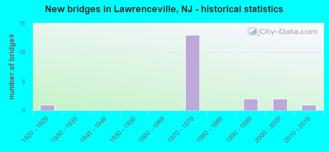
- New bridges - historical statistics
- 11920-1929
- 131970-1979
- 21990-1999
- 22000-2009
- 12010-2019


- Bridge Condition - Deck
- 54.5%Good
- 45.5%Satisfactory

- Bridge Condition - Superstructure
- 33.3%Very good
- 16.7%Good
- 25.0%Satisfactory
- 16.7%Fair
- 8.3%Poor

- Bridge Condition - Substructure
- 25.0%Very good
- 41.7%Good
- 25.0%Satisfactory
- 8.3%Fair

- Bridge Condition - Channel
- 44.4%Good
- 33.3%Satisfactory
- 22.2%Fair

- Bridge Condition - Culverts
- 50.0%Good
- 50.0%Satisfactory
Find on map >> Show street view
Structure Number: 1100018, Location: 0.58 MI S OF I-95 JCT (Lat: 40.278931, Lng: -74.717750), Route carried "on" structure: County highway 583, Year Built: 1999, Status: Open, Structure Length: 1.10m (3.61ft), Average Daily Traffic: 12,994 (year 2021), Truck Traffic: 4%, Average Future Daily Traffic: 15,592 (year 2041), Features Intersected: FIVE MILE RUN, Facility Carried by Structure: PRINCETON PIKE
Minimum Vertical Clearance: 30+ m (98+ ft), Kilometerpoint: 5.584, Lanes on structure: 2, Owner: County Highway Agency, Approaching Roadway Width: 13.4m (44.0ft), Material/Design: Prestressed concrete, Design/Construction: Slab, Number Of Spans In Main Unit: 1, Length of Maximum Span: 9.8m (32.2ft), Curb or Sidewalk Widths: Left: 1.8m (5.9ft), Right: 1.8m (5.9ft), Curb-To-Curb Width: 13.4m (44.0ft), Out-to-Out Width: 17.7m (58.1ft)
Condition: Deck: Satisfactory, Superstructure: Very good, Substructure: Very good, Channel: Good, Operating Rating: 82.6 metric tons, Method Used To Determine Operating Rating: Load Factor (LF), Inventory Rating: 49.9 metric tons, Method Used To Determine Inventory Rating: Load Factor (LF), Structural Evaluation: Equal to present desirable criteria, Deck Geometry: Equal to present minimum criteria, Waterway Adequacy: Equal to present minimum criteria, Approach Roadway Alignment: Equal to present desirable criteria, Designated Inspection Frequency: Every 24 months, Inspection Date: Febuary 2021, Deck Structure Type: Concrete Cast-file-Place, Wearing Surface/Protective System: Wearing Surface: Monolithic Concrete, Deck Protection: Epoxy Coated Reinforcing
Find on map >> Show street view
Structure Number: 1100021, Location: 0.3 mile North of US 205 (Lat: 40.313789, Lng: -74.713700), Route carried "on" structure: County highway 569, Year Built: 2016, Status: Open, Structure Length: 1.04m (3.41ft), Average Daily Traffic: 7,895 (year 2021), Truck Traffic: 4%, Average Future Daily Traffic: 9,635 (year 2041), Design Load: HL 93, Features Intersected: SHIPETAUKIN CREEK
Minimum Vertical Clearance: 30+ m (98+ ft), Kilometerpoint: 3.846, Lanes on structure: 2, Owner: County Highway Agency, Approaching Roadway Width: 11.6m (38.1ft), Material/Design: Concrete, Design/Construction: Box Beam or Girders - Multiple, Number Of Spans In Main Unit: 1, Length of Maximum Span: 10.1m (33.1ft), Curb or Sidewalk Widths: Left: 1.4m (4.6ft), Right: 0.0m, Curb-To-Curb Width: 11.6m (38.1ft), Out-to-Out Width: 14.0m (45.9ft)
Condition: Deck: Good, Superstructure: Very good, Substructure: Very good, Channel: Good, Operating Rating: 59.3 metric tons, Method Used To Determine Operating Rating: Load and Resistance Factor Rating (LRFR) rating reported by rating factor(RF) method using HL-93 loadings, Inventory Rating: 45.7 metric tons, Method Used To Determine Inventory Rating: Load and Resistance Factor Rating (LRFR) rating reported by rating factor(RF) method using HL-93 loadings, Structural Evaluation: Equal to present desirable criteria, Deck Geometry: Somewhat better than minimum adequacy, Waterway Adequacy: Superior to present desirable criteria, Approach Roadway Alignment: Equal to present minimum criteria, Designated Inspection Frequency: Every 24 months, Inspection Date: Febuary 2021, Bridge Improvement Cost: $546,000, Roadway Improvement Cost: $88,000, Total Project Cost: $860,000, Deck Structure Type: Concrete Cast-file-Place, Wearing Surface/Protective System: Wearing Surface: Monolithic Concrete, Deck Protection: Galvanized Reinforcing
Find on map >> Show street view
Structure Number: 1102321, Location: 0.83 mile W. of CR 569 (Lat: 40.340831, Lng: -74.743569), Route carried "on" structure: County highway 625, Year Built: 1970, Year Reconstructed: 2013, Status: Open, Structure Length: 2.56m (8.40ft), Average Daily Traffic: 3,570 (year 2021), Truck Traffic: 3%, Average Future Daily Traffic: 4,360 (year 2041), Design Load: HS 20, Features Intersected: HONEY BRANCH BROOK
Minimum Vertical Clearance: 30+ m (98+ ft), Kilometerpoint: 2.221, Lanes on structure: 2, Owner: County Highway Agency, Approaching Roadway Width: 6.7m (22.0ft), Material/Design: Steel, Design/Construction: Stringer/Multi-beam, Number Of Spans In Main Unit: 1, Length of Maximum Span: 24.4m (80.1ft), Curb or Sidewalk Widths: Left: 0.9m (3.0ft), Right: 0.9m (3.0ft), Curb-To-Curb Width: 9.9m (32.5ft), Out-to-Out Width: 12.3m (40.4ft)
Condition: Deck: Good, Superstructure: Fair, Substructure: Satisfactory, Channel: Fair, Operating Rating: 64.4 metric tons, Method Used To Determine Operating Rating: Load Factor (LF), Inventory Rating: 38.1 metric tons, Method Used To Determine Inventory Rating: Load Factor (LF), Structural Evaluation: Somewhat better than minimum adequacy, Deck Geometry: Meets minimum limits, Waterway Adequacy: Superior to present desirable criteria, Approach Roadway Alignment: Better than present minimum criteria, Designated Inspection Frequency: Every 24 months, Inspection Date: Febuary 2021, Deck Structure Type: Concrete Cast-file-Place, Wearing Surface/Protective System: Wearing Surface: Integral Concrete
Find on map >> Show street view
Structure Number: 1102415, Location: 0.64 Mi E. OF RT. 31 (Lat: 40.296311, Lng: -74.771639), Route carried "on" structure: City street , Year Built: 1994, Status: Open, Structure Length: 0.67m (2.20ft), Average Daily Traffic: 459 (year 2021), Truck Traffic: 1%, Average Future Daily Traffic: 550 (year 2041), Design Load: HS 20+Mod, Features Intersected: SHABAKUNK CREEK, Facility Carried by Structure: BRANDON ROAD WEST
Minimum Vertical Clearance: 30+ m (98+ ft), Kilometerpoint: 0.000, Lanes on structure: 2, Owner: County Highway Agency, Approaching Roadway Width: 11.0m (36.1ft), Skew: 2 degrees, Material/Design: Concrete, Design/Construction: Culvert, Number Of Spans In Main Unit: 1, Length of Maximum Span: 6.7m (22.0ft), Curb or Sidewalk Widths: Left: 3.0m (9.8ft), Right: 3.0m (9.8ft), Curb-To-Curb Width: 11.0m (36.1ft), Out-to-Out Width: 17.9m (58.7ft)
Condition: Channel: Good, Culverts: Good, Operating Rating: 59.0 metric tons, Method Used To Determine Operating Rating: Load Factor (LF), Inventory Rating: 35.4 metric tons, Method Used To Determine Inventory Rating: Load Factor (LF), Structural Evaluation: Better than present minimum criteria, Deck Geometry: Better than present minimum criteria, Waterway Adequacy: Better than present minimum criteria, Approach Roadway Alignment: Better than present minimum criteria, Designated Inspection Frequency: Every 24 months, Inspection Date: Febuary 2021
Find on map >> Show street view
Structure Number: 1120164, Location: 1.01 MI NORTH NJ RT 31 (Lat: 40.289811, Lng: -74.766619), Route carried "on" structure: Interstate 295, Year Built: 1973, Status: Open, Structure Length: 0.67m (2.20ft), Average Daily Traffic: 31,944 (year 2019), Truck Traffic: 9%, Average Future Daily Traffic: 38,978 (year 2039), Design Load: HS 20+Mod, Features Intersected: SHABAKUNK CREEK BRANCH
Minimum Vertical Clearance: 30+ m (98+ ft), Kilometerpoint: 114.762, Lanes on structure: 3, Base Highway Network: Yes, Owner: State Highway Agency, Approaching Roadway Width: 12.8m (42.0ft), Skew: 3 degrees, Material/Design: Concrete, Design/Construction: Culvert, Number Of Spans In Main Unit: 1, Length of Maximum Span: 6.7m (22.0ft)
Condition: Channel: Good, Culverts: Satisfactory, Inventory Rating: 66.2 metric tons, Method Used To Determine Inventory Rating: Load Factor (LF), Structural Evaluation: Equal to present minimum criteria, Waterway Adequacy: Superior to present desirable criteria, Approach Roadway Alignment: Equal to present desirable criteria, Designated Inspection Frequency: Every 24 months, Inspection Date: July 2021
Find on map >> Show street view
Structure Number: 1129151, Location: 0.84 MI S OF I-295 JCT (Lat: 40.273539, Lng: -74.733839), Route carried "on" structure: US 206, Year Built: 2000, Status: Open, Structure Length: 1.10m (3.61ft), Average Daily Traffic: 19,131 (year 2021), Truck Traffic: 4%, Average Future Daily Traffic: 27,010 (year 2041), Design Load: HS 20+Mod, Features Intersected: FIVE MILE RUN
Minimum Vertical Clearance: 30+ m (98+ ft), Kilometerpoint: 75.897, Lanes on structure: 2, Base Highway Network: Yes, Owner: State Highway Agency, Approaching Roadway Width: 16.8m (55.1ft), Skew: 1 degrees, Material/Design: Prestressed concrete, Design/Construction: Slab, Number Of Spans In Main Unit: 1, Length of Maximum Span: 10.4m (34.1ft), Curb or Sidewalk Widths: Left: 1.8m (5.9ft), Right: 1.8m (5.9ft), Curb-To-Curb Width: 16.8m (55.1ft), Out-to-Out Width: 21.1m (69.2ft)
Condition: Deck: Good, Superstructure: Very good, Substructure: Good, Channel: Satisfactory, Structural Evaluation: Better than present minimum criteria, Deck Geometry: Superior to present desirable criteria, Waterway Adequacy: Superior to present desirable criteria, Approach Roadway Alignment: Equal to present desirable criteria, Designated Inspection Frequency: Every 24 months, Underwater Inspection Frequency: Every 24 months, Inspection Date: March 2021, Underwater Inspection Date: April 2021, Deck Structure Type: Concrete Cast-file-Place, Wearing Surface/Protective System: Wearing Surface: Bituminous, Deck Protection: Epoxy Coated Reinforcing
Find on map >> Show street view
Structure Number: 1129153, Location: 0.1 MILE NORTH OF 569 JCT (Lat: 40.310419, Lng: -74.710881), Route carried "on" structure: US 206, Year Built: 1923, Status: Open, Structure Length: 1.80m (5.91ft), Average Daily Traffic: 16,883 (year 2021), Truck Traffic: 4%, Average Future Daily Traffic: 20,619 (year 2041), Design Load: H 20, Features Intersected: SHIPETAUKIN CREEK
Minimum Vertical Clearance: 30+ m (98+ ft), Kilometerpoint: 80.934, Lanes on structure: 2, Base Highway Network: Yes, Owner: State Highway Agency, Approaching Roadway Width: 12.2m (40.0ft), Skew: 1 degrees, Material/Design: Concrete, Design/Construction: Arch - Deck, Number Of Spans In Main Unit: 1, Length of Maximum Span: 15.8m (51.8ft), Curb-To-Curb Width: 12.2m (40.0ft), Out-to-Out Width: 13.6m (44.6ft)
Condition: Superstructure: Fair, Substructure: Fair, Channel: Satisfactory, Structural Evaluation: Somewhat better than minimum adequacy, Deck Geometry: Somewhat better than minimum adequacy, Waterway Adequacy: Equal to present desirable criteria, Approach Roadway Alignment: Equal to present minimum criteria, Designated Inspection Frequency: Every 24 months, Inspection Date: March 2021
Find on map >> Show street view
Structure Number: 1138171, Location: 1 MI N OF US 1 & I295 JCT (Lat: 40.285731, Lng: -74.713189), Route carried "on" structure: County highway 583, Year Built: 1973, Status: Open, Structure Length: 8.53m (27.99ft), Average Daily Traffic: 12,995 (year 2021), Truck Traffic: 4%, Average Future Daily Traffic: 15,594 (year 2041), Design Load: HS 20, Features Intersected: I-295, RAMPS B AND D, Facility Carried by Structure: PRINCETON PIKE
Minimum Vertical Clearance: 30+ m (98+ ft), Kilometerpoint: 6.453, Lanes on structure: 4, Lanes under structure: 8, Owner: State Highway Agency, Approaching Roadway Width: 23.2m (76.1ft), Skew: 23 degrees, Material/Design: Steel, Design/Construction: Stringer/Multi-beam, Number Of Spans In Main Unit: 2, Length of Maximum Span: 41.5m (136.2ft), Curb or Sidewalk Widths: Left: 1.8m (5.9ft), Right: 1.8m (5.9ft), Curb-To-Curb Width: 23.2m (76.1ft), Out-to-Out Width: 29.3m (96.1ft)
Condition: Deck: Satisfactory, Superstructure: Poor, Substructure: Good, Inventory Rating: 62.6 metric tons, Method Used To Determine Inventory Rating: Load Factor (LF), Structural Evaluation: Meets minimum limits, Deck Geometry: Superior to present desirable criteria, Underclear: High priority of corrective action, Approach Roadway Alignment: Better than present minimum criteria, Length Of Structure Improvement: 8.53m (27.99ft), Designated Inspection Frequency: Every 24 months, Other Special Inspection Frequency: Every 12 months, Inspection Date: March 2021, Other Special Inspection Date: March 2021, Bridge Improvement Cost: $7,000, Roadway Improvement Cost: $3,380,000, Total Project Cost: $8,000 ( Estimate for 2021), Deck Structure Type: Concrete Cast-file-Place, Wearing Surface/Protective System: Wearing Surface: Monolithic Concrete
Find on map >> Show street view
Structure Number: 1138172, Location: 1.5 MI NORTH OF RT 1 (Lat: 40.285711, Lng: -74.723881), Route carried "on" structure: Interstate 295, Year Built: 1973, Status: Open, Structure Length: 4.88m (16.01ft), Average Daily Traffic: 48,745 (year 2021), Truck Traffic: 9%, Average Future Daily Traffic: 58,494 (year 2041), Design Load: HS 20+Mod, Features Intersected: FRANKLIN CORNER RD (546)
Minimum Vertical Clearance: 30+ m (98+ ft), Kilometerpoint: 111.029, Lanes on structure: 3, Lanes under structure: 2, Base Highway Network: Yes, Owner: State Highway Agency, Approaching Roadway Width: 16.6m (54.5ft), Skew: 4 degrees, Material/Design: Steel, Design/Construction: Stringer/Multi-beam, Number Of Spans In Main Unit: 1, Length of Maximum Span: 46.9m (153.9ft), Curb-To-Curb Width: 16.6m (54.5ft), Out-to-Out Width: 17.7m (58.1ft)
Condition: Deck: Good, Superstructure: Satisfactory, Substructure: Good, Inventory Rating: 59.9 metric tons, Method Used To Determine Inventory Rating: Load Factor (LF), Structural Evaluation: Equal to present minimum criteria, Deck Geometry: Equal to present minimum criteria, Underclear: High priority of corrective action, Approach Roadway Alignment: Equal to present desirable criteria, Length Of Structure Improvement: 4.88m (16.01ft), Designated Inspection Frequency: Every 24 months, Inspection Date: March 2021, Deck Structure Type: Concrete Cast-file-Place, Wearing Surface/Protective System: Wearing Surface: Bituminous
Find on map >> Show street view
Structure Number: 1138173, Location: 0.46 MI S. of US 206 JCT (Lat: 40.285281, Lng: -74.723819), Route carried "on" structure: Interstate 295, Year Built: 1973, Status: Open, Structure Length: 4.94m (16.21ft), Average Daily Traffic: 96,552 (year 2020), Truck Traffic: 9%, Average Future Daily Traffic: 117,929 (year 2040), Design Load: HS 20, Features Intersected: FRANKLIN CORNER ROAD
Minimum Vertical Clearance: 30.45m (99.90ft), Kilometerpoint: 111.029, Lanes on structure: 3, Lanes under structure: 2, Base Highway Network: Yes, Owner: State Highway Agency, Approaching Roadway Width: 16.6m (54.5ft), Skew: 4 degrees, Material/Design: Steel, Design/Construction: Stringer/Multi-beam, Number Of Spans In Main Unit: 1, Length of Maximum Span: 46.9m (153.9ft), Curb-To-Curb Width: 16.6m (54.5ft), Out-to-Out Width: 17.7m (58.1ft)
Condition: Deck: Good, Superstructure: Good, Substructure: Satisfactory, Operating Rating: 46.3 metric tons, Method Used To Determine Operating Rating: Load Factor (LF), Inventory Rating: 28.1 metric tons, Method Used To Determine Inventory Rating: Load Factor (LF), Structural Evaluation: Equal to present minimum criteria, Deck Geometry: Equal to present minimum criteria, Underclear: Better than present minimum criteria, Approach Roadway Alignment: Equal to present desirable criteria, Designated Inspection Frequency: Every 24 months, Inspection Date: January 2020, Deck Structure Type: Concrete Cast-file-Place, Wearing Surface/Protective System: Wearing Surface: Bituminous
Find on map >> Show street view
Structure Number: 1138174, Location: 1.9 MI SOUTH OF RT US 1 (Lat: 40.285439, Lng: -74.732419), Route carried "on" structure: US 206, Year Built: 1973, Status: Open, Structure Length: 7.53m (24.70ft), Average Daily Traffic: 15,200 (year 2020), Truck Traffic: 4%, Average Future Daily Traffic: 18,546 (year 2040), Design Load: HS 20+Mod, Features Intersected: ROUTE I-295
Minimum Vertical Clearance: 30+ m (98+ ft), Kilometerpoint: 77.281, Lanes on structure: 4, Lanes under structure: 8, Base Highway Network: Yes, Owner: State Highway Agency, Approaching Roadway Width: 23.2m (76.1ft), Skew: 31 degrees, Material/Design: Steel, Design/Construction: Stringer/Multi-beam, Number Of Spans In Main Unit: 2, Length of Maximum Span: 36.6m (120.1ft), Curb or Sidewalk Widths: Left: 1.9m (6.2ft), Right: 1.9m (6.2ft), Curb-To-Curb Width: 23.0m (75.5ft), Out-to-Out Width: 29.3m (96.1ft)
Condition: Deck: Satisfactory, Superstructure: Satisfactory, Substructure: Good, Operating Rating: 88.0 metric tons, Method Used To Determine Operating Rating: Load Factor (LF), Inventory Rating: 52.6 metric tons, Method Used To Determine Inventory Rating: Load Factor (LF), Structural Evaluation: Equal to present minimum criteria, Deck Geometry: Superior to present desirable criteria, Underclear: High priority of replacement, Approach Roadway Alignment: Equal to present desirable criteria, Length Of Structure Improvement: 7.53m (24.70ft), Designated Inspection Frequency: Every 24 months, Inspection Date: August 2020, Bridge Improvement Cost: $974,000, Roadway Improvement Cost: $189,000, Total Project Cost: $1,629,000 ( Estimate for 2020), Deck Structure Type: Concrete Cast-file-Place, Wearing Surface/Protective System: Wearing Surface: Monolithic Concrete
Find on map >> Show street view
Structure Number: 1138175, Location: 3.4 MI SOUTH OF RT US 1 (Lat: 40.287381, Lng: -74.760000), Route carried "on" structure: Other road , Year Built: 1973, Status: Open, Structure Length: 7.89m (25.89ft), Average Daily Traffic: 6,495 (year 2021), Truck Traffic: 4%, Average Future Daily Traffic: 7,933 (year 2041), Design Load: HS 20, Features Intersected: RT I-295, Facility Carried by Structure: FEDERAL CITY ROAD
Minimum Vertical Clearance: 30+ m (98+ ft), Kilometerpoint: 1.754, Lanes on structure: 3, Lanes under structure: 8, Owner: State Highway Agency, Approaching Roadway Width: 16.8m (55.1ft), Skew: 2 degrees, Material/Design: Steel, Design/Construction: Stringer/Multi-beam, Number Of Spans In Main Unit: 2, Length of Maximum Span: 39.3m (128.9ft), Curb or Sidewalk Widths: Left: 1.8m (5.9ft), Right: 1.8m (5.9ft), Curb-To-Curb Width: 16.9m (55.4ft), Out-to-Out Width: 21.2m (69.6ft)
Condition: Deck: Satisfactory, Superstructure: Satisfactory, Substructure: Satisfactory, Inventory Rating: 57.2 metric tons, Method Used To Determine Inventory Rating: Load Factor (LF), Structural Evaluation: Equal to present minimum criteria, Deck Geometry: Superior to present desirable criteria, Underclear: High priority of corrective action, Approach Roadway Alignment: Equal to present desirable criteria, Length Of Structure Improvement: 9.08m (29.79ft), Designated Inspection Frequency: Every 24 months, Inspection Date: September 2021, Bridge Improvement Cost: $807,000, Roadway Improvement Cost: $162,000, Total Project Cost: $1,172,000 ( Estimate for 2021), Deck Structure Type: Concrete Cast-file-Place, Wearing Surface/Protective System: Wearing Surface: Monolithic Concrete
Find on map >> Show street view
Structure Number: 1154219, Location: 0.4 MI SW OF 583/546 JCT (Lat: 40.277369, Lng: -74.723000), Route carried "on" structure: City street , Year Built: 1971, Status: Open, Structure Length: 1.28m (4.20ft), Average Daily Traffic: 61 (year 2021), Truck Traffic: 1%, Average Future Daily Traffic: 73 (year 2041), Features Intersected: FIVE MILE RUN, Facility Carried by Structure: BALSAM DRIVE
Minimum Vertical Clearance: 30+ m (98+ ft), Kilometerpoint: 0.000, Lanes on structure: 2, Owner: County Highway Agency, Approaching Roadway Width: 9.1m (29.9ft), Skew: 1 degrees, Material/Design: Prestressed concrete, Design/Construction: Slab, Number Of Spans In Main Unit: 1, Length of Maximum Span: 11.9m (39.0ft), Curb or Sidewalk Widths: Left: 2.2m (7.2ft), Right: 2.2m (7.2ft), Curb-To-Curb Width: 9.2m (30.2ft), Out-to-Out Width: 13.6m (44.6ft)
Condition: Deck: Satisfactory, Superstructure: Good, Substructure: Good, Channel: Fair, Operating Rating: 65.3 metric tons, Method Used To Determine Operating Rating: Load Factor (LF), Inventory Rating: 39.0 metric tons, Method Used To Determine Inventory Rating: Load Factor (LF), Structural Evaluation: Better than present minimum criteria, Deck Geometry: Better than present minimum criteria, Waterway Adequacy: Better than present minimum criteria, Approach Roadway Alignment: Equal to present desirable criteria, Designated Inspection Frequency: Every 24 months, Inspection Date: Febuary 2021, Deck Structure Type: Concrete Cast-file-Place, Wearing Surface/Protective System: Wearing Surface: Monolithic Concrete
Find on map >> Show street view
Structure Number: 1154319, Location: 0.04 mi South of US 206 (Lat: 40.310239, Lng: -74.710589), Route carried "on" structure: County highway 569, Year Built: 2003, Status: Open, Structure Length: 1.74m (5.71ft), Average Daily Traffic: 5,460 (year 2019), Truck Traffic: 4%, Average Future Daily Traffic: 6,552 (year 2039), Design Load: HS 20+Mod, Features Intersected: SHIPETAUKIN CREEK
Minimum Vertical Clearance: 30+ m (98+ ft), Kilometerpoint: 3.251, Lanes on structure: 2, Owner: County Highway Agency, Approaching Roadway Width: 11.9m (39.0ft), Skew: 1 degrees, Material/Design: Steel, Design/Construction: Truss - Thru, Number Of Spans In Main Unit: 1, Length of Maximum Span: 15.5m (50.9ft), Curb-To-Curb Width: 11.0m (36.1ft), Out-to-Out Width: 11.7m (38.4ft)
Condition: Deck: Good, Superstructure: Very good, Substructure: Very good, Channel: Satisfactory, Operating Rating: 58.1 metric tons, Method Used To Determine Operating Rating: Load Factor (LF), Inventory Rating: 22.7 metric tons, Method Used To Determine Inventory Rating: Load Factor (LF), Structural Evaluation: Somewhat better than minimum adequacy, Deck Geometry: Meets minimum limits, Waterway Adequacy: Equal to present minimum criteria, Approach Roadway Alignment: Meets minimum limits, Designated Inspection Frequency: Every 24 months, Critical Feature Inspection Frequency: Every 24 months, Inspection Date: Febuary 2021, Critical Feature Inspection Date: Febuary 2021, Deck Structure Type: Concrete Cast-file-Place, Wearing Surface/Protective System: Wearing Surface: Monolithic Concrete, Deck Protection: Epoxy Coated Reinforcing
Find on map >> Show street view
Structure Number: 1138171, Location: 1 MI N OF US 1 & I295 JCT (Lat: 40.285731, Lng: -74.713189), Route carried "under" structure: Interstate 295, Year Built: 1973, Structure Length: 0. m, Average Daily Traffic: 97,490 (year 2021), Truck Traffic: 9%, Features Intersected: I-295, RAMPS B AND D, Facility Carried by Structure: PRINCETON PIKE
Minimum Vertical Clearance: 4.78m (15.68ft), Kilometerpoint: 110.127, Lanes on structure: 4, Lanes under structure: 8, Material/Design: Steel, Design/Construction: Stringer/Multi-beam, Length of Maximum Span: 41.5m (136.2ft)
Find on map >> Show street view
Structure Number: 1138172, Location: 1.5 MI NORTH OF RT 1 (Lat: 40.285711, Lng: -74.723881), Route carried "under" structure: County highway 546, Year Built: 1973, Structure Length: 0. m, Average Daily Traffic: 9,902 (year 2021), Truck Traffic: 4%, Features Intersected: FRANKLIN CORNER RD (546), Facility Carried by Structure: I-295 NORTHBOUND
Minimum Vertical Clearance: 4.24m (13.91ft), Kilometerpoint: 14.082, Lanes on structure: 3, Lanes under structure: 2, Material/Design: Steel, Design/Construction: Stringer/Multi-beam, Length of Maximum Span: 46.9m (153.9ft)
Find on map >> Show street view
Structure Number: 1138173, Location: 0.46 MI S. of US 206 JCT (Lat: 40.285281, Lng: -74.723819), Route carried "under" structure: County highway 546, Year Built: 1973, Structure Length: 0. m, Average Daily Traffic: 10,611 (year 2020), Truck Traffic: 4%, Features Intersected: FRANKLIN CORNER ROAD, Facility Carried by Structure: I-295 SOUTHBOUND
Minimum Vertical Clearance: 4.86m (15.94ft), Kilometerpoint: 14.082, Lanes on structure: 3, Lanes under structure: 2, Material/Design: Steel, Design/Construction: Stringer/Multi-beam, Length of Maximum Span: 46.9m (153.9ft)
Find on map >> Show street view
Structure Number: 1138174, Location: 1.9 MI SOUTH OF RT US 1 (Lat: 40.285439, Lng: -74.732419), Route carried "under" structure: Interstate 295, Year Built: 1973, Structure Length: 0. m, Average Daily Traffic: 113,580 (year 2020), Truck Traffic: 9%, Features Intersected: ROUTE I-295, Facility Carried by Structure: US RT 206
Minimum Vertical Clearance: 4.67m (15.32ft), Kilometerpoint: 111.769, Lanes on structure: 4, Lanes under structure: 8, Material/Design: Steel, Design/Construction: Stringer/Multi-beam, Length of Maximum Span: 36.6m (120.1ft)
Find on map >> Show street view
Structure Number: 1138175, Location: 3.4 MI SOUTH OF RT US 1 (Lat: 40.287381, Lng: -74.760000), Route carried "under" structure: Interstate 295, Year Built: 1973, Structure Length: 0. m, Average Daily Traffic: 8,933 (year 2021), Truck Traffic: 9%, Features Intersected: RT I-295, Facility Carried by Structure: FEDERAL CITY ROAD
Minimum Vertical Clearance: 4.55m (14.93ft), Kilometerpoint: 114.135, Lanes on structure: 3, Lanes under structure: 8, Material/Design: Steel, Design/Construction: Stringer/Multi-beam, Length of Maximum Span: 39.3m (128.9ft)