Bridge Statistics for Lawson Heights, Pennsylvania (PA)
Condition, Traffic, Stress, Structural Evaluation, Project Costs
- National Bridge Inventory (NBI) Statistics
- 19Number of bridges
- 112ft / 34.2mTotal length
- $2,494,000Total costs
- 126,704Total average daily traffic
- 10,531Total average daily truck traffic
- National Bridge Inventory (NBI) Registered Bridges for Lawson Heights
- No street view available for this location
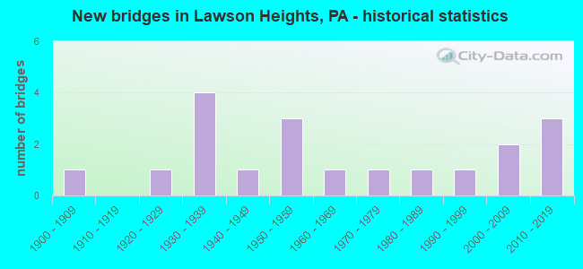
- New bridges - historical statistics
- 11900-1909
- 11920-1929
- 41930-1939
- 11940-1949
- 31950-1959
- 11960-1969
- 11970-1979
- 11980-1989
- 11990-1999
- 22000-2009
- 32010-2019

- Reconstructed bridges - Historical Statistics
- 11960-1969
- 01970-1979
- 01980-1989
- 31990-1999
- 12000-2009
- 32010-2019


- Bridge Condition - Deck
- 33.3%Very good
- 16.7%Good
- 41.7%Satisfactory
- 8.3%Critical

- Bridge Condition - Superstructure
- 50.0%Very good
- 14.3%Satisfactory
- 28.6%Fair
- 7.1%Critical

- Bridge Condition - Substructure
- 14.3%Very good
- 21.4%Good
- 35.7%Satisfactory
- 21.4%Fair
- 7.1%Poor

- Bridge Condition - Channel
- 6.3%Very good
- 12.5%Good
- 62.5%Satisfactory
- 12.5%Fair
- 6.3%Poor

- Bridge Condition - Culverts
- 33.3%Good
- 33.3%Satisfactory
- 33.3%Fair
Find on map >> Show street view
Structure Number: 495, Location: 450'S.OF SR 1013 (Lat: 40.510067, Lng: -79.946106), Route carried "on" structure: State highway 8, Year Built: 1925, Year Reconstructed: 2007, Status: Open, Structure Length: 3.38m (11.09ft), Average Daily Traffic: 32,865 (year 2022), Truck Traffic: 10%, Average Future Daily Traffic: 25,224 (year 2032), Design Load: HS 20, Features Intersected: PINE CREEK
Minimum Vertical Clearance: 30+ m (98+ ft), Kilometerpoint: 13.061, Lanes on structure: 4, Base Highway Network: Yes, Owner: State Highway Agency, Approaching Roadway Width: 15.2m (49.9ft), Skew: 24 degrees, Material/Design: Concrete, Design/Construction: Arch - Deck, Number Of Spans In Main Unit: 1, Length of Maximum Span: 21.0m (68.9ft), Curb or Sidewalk Widths: Left: 1.6m (5.2ft), Right: 1.3m (4.3ft), Curb-To-Curb Width: 15.3m (50.2ft), Out-to-Out Width: 18.9m (62.0ft)
Condition: Superstructure: Fair, Substructure: Fair, Channel: Satisfactory, Operating Rating: 49.0 metric tons, Method Used To Determine Operating Rating: Field evaluation and documented engineering judgment, Inventory Rating: 32.7 metric tons, Method Used To Determine Inventory Rating: Field evaluation and documented engineering judgment, Structural Evaluation: Somewhat better than minimum adequacy, Deck Geometry: High priority of corrective action, Waterway Adequacy: Equal to present minimum criteria, Approach Roadway Alignment: Equal to present desirable criteria, Length Of Structure Improvement: 3.40m (11.15ft), Designated Inspection Frequency: Every 24 months, Inspection Date: October 2019, Bridge Improvement Cost: $19,000, Roadway Improvement Cost: $55,000, Total Project Cost: $253,000
Find on map >> Show street view
Structure Number: 2162, Location: IW01 IRWIN RUN NO. 1 (Lat: 40.597589, Lng: -79.997853), Route carried "on" structure: County highway , Year Built: 1936, Status: Open, Structure Length: 0.70m (2.30ft), Average Daily Traffic: 3,569 (year 2005), Truck Traffic: 3%, Average Future Daily Traffic: 3,569 (year 2023), Features Intersected: IRWIN RUN, Facility Carried by Structure: PEARCE MILL RD
Minimum Vertical Clearance: 30+ m (98+ ft), Kilometerpoint: 0.000, Lanes on structure: 2, Owner: County Highway Agency, Approaching Roadway Width: 13.1m (43.0ft), Material/Design: Concrete, Design/Construction: Arch - Deck, Number Of Spans In Main Unit: 1, Length of Maximum Span: 7.0m (23.0ft), Curb or Sidewalk Widths: Left: 0.0m, Right: 3.2m (10.5ft), Curb-To-Curb Width: 14.1m (46.3ft), Out-to-Out Width: 15.3m (50.2ft)
Condition: Superstructure: Satisfactory, Substructure: Satisfactory, Channel: Good, Operating Rating: 53.5 metric tons, Method Used To Determine Operating Rating: Field evaluation and documented engineering judgment, Inventory Rating: 31.8 metric tons, Method Used To Determine Inventory Rating: Field evaluation and documented engineering judgment, Structural Evaluation: Equal to present minimum criteria, Deck Geometry: Superior to present desirable criteria, Waterway Adequacy: Superior to present desirable criteria, Approach Roadway Alignment: Equal to present desirable criteria, Length Of Structure Improvement: 1.20m (3.94ft), Designated Inspection Frequency: Every 24 months, Underwater Inspection Frequency: Every 60 months, Inspection Date: June 2021, Underwater Inspection Date: December 2020
Find on map >> Show street view
Structure Number: 2163, Location: PN03 PINE CREEK,N BR,#3 (Lat: 40.608561, Lng: -80.015967), Route carried "on" structure: County highway , Year Built: 1939, Year Reconstructed: 1990, Status: Open, Structure Length: 1.71m (5.61ft), Average Daily Traffic: 2,227 (year 2005), Truck Traffic: 2%, Average Future Daily Traffic: 2,227 (year 2024), Features Intersected: PINE CREEK NORTH BRANCH, Facility Carried by Structure: WALTER RD
Minimum Vertical Clearance: 30+ m (98+ ft), Kilometerpoint: 0.000, Lanes on structure: 2, Owner: County Highway Agency, Approaching Roadway Width: 12.2m (40.0ft), Skew: 3 degrees, Material/Design: Concrete, Design/Construction: Culvert, Number Of Spans In Main Unit: 1, Length of Maximum Span: 17.1m (56.1ft), Curb or Sidewalk Widths: Left: 2.9m (9.5ft), Right: 2.4m (7.9ft), Curb-To-Curb Width: 12.0m (39.4ft), Out-to-Out Width: 18.4m (60.4ft)
Condition: Channel: Satisfactory, Culverts: Satisfactory, Operating Rating: 38.1 metric tons, Method Used To Determine Operating Rating: Field evaluation and documented engineering judgment, Inventory Rating: 22.7 metric tons, Method Used To Determine Inventory Rating: Field evaluation and documented engineering judgment, Structural Evaluation: Equal to present minimum criteria, Deck Geometry: Somewhat better than minimum adequacy, Waterway Adequacy: Superior to present desirable criteria, Approach Roadway Alignment: Equal to present desirable criteria, Length Of Structure Improvement: 1.70m (5.58ft), Designated Inspection Frequency: Every 24 months, Inspection Date: May 2021
Find on map >> Show street view
Structure Number: 5855, Location: VILLAGE OF GREENWOOD (Lat: 40.532408, Lng: -78.371494), Route carried "on" structure: State highway , Year Built: 1952, Year Reconstructed: 2010, Status: Open, Structure Length: 0.98m (3.22ft), Average Daily Traffic: 6,685 (year 2021), Truck Traffic: 9%, Average Future Daily Traffic: 9,763 (year 2032), Design Load: HL 93, Features Intersected: KETTLE CREEK, Facility Carried by Structure: SR 4016
Minimum Vertical Clearance: 30+ m (98+ ft), Kilometerpoint: 0.000, Lanes on structure: 2, Owner: State Highway Agency, Approaching Roadway Width: 9.4m (30.8ft), Skew: 4 degrees, Material/Design: Prestressed concrete, Design/Construction: Slab, Number Of Spans In Main Unit: 1, Length of Maximum Span: 9.1m (29.9ft), Curb-To-Curb Width: 12.6m (41.3ft), Out-to-Out Width: 13.5m (44.3ft)
Condition: Deck: Very good, Superstructure: Very good, Substructure: Good, Channel: Satisfactory, Operating Rating: 66.4 metric tons, Method Used To Determine Operating Rating: Assigned ratings based on Load and Resistance Factor Design (LRFD) reported by rating factor (RF) using HL93 loadings, Inventory Rating: 35.6 metric tons, Method Used To Determine Inventory Rating: Assigned ratings based on Load and Resistance Factor Design (LRFD) reported by rating factor (RF) using HL93 loadings, Structural Evaluation: Better than present minimum criteria, Deck Geometry: Somewhat better than minimum adequacy, Waterway Adequacy: Equal to present minimum criteria, Approach Roadway Alignment: Equal to present desirable criteria, Length Of Structure Improvement: 8.80m (28.87ft), Designated Inspection Frequency: Every 24 months, Inspection Date: March 2021, Wearing Surface/Protective System: Wearing Surface: Bituminous, Membrane: Preformed Fabric, Deck Protection: Epoxy Coated Reinforcing
Find on map >> Show street view
Structure Number: 5885, Location: 0.1 MILE NORTH OF TYRONE (Lat: 40.692167, Lng: -78.240586), Route carried "on" structure: State highway , Year Built: 1937, Year Reconstructed: 2010, Status: Open, Structure Length: 1.10m (3.61ft), Average Daily Traffic: 235 (year 2022), Truck Traffic: 8%, Average Future Daily Traffic: 266 (year 2032), Design Load: HL 93, Features Intersected: DECKER RUN, Facility Carried by Structure: T527 DECKER HOLLOW
Minimum Vertical Clearance: 30+ m (98+ ft), Kilometerpoint: 0.280, Lanes on structure: 2, Owner: State Highway Agency, Approaching Roadway Width: 7.6m (24.9ft), Skew: 4 degrees, Material/Design: Steel, Design/Construction: Stringer/Multi-beam, Number Of Spans In Main Unit: 1, Length of Maximum Span: 10.1m (33.1ft), Curb-To-Curb Width: 7.3m (24.0ft), Out-to-Out Width: 7.9m (25.9ft)
Condition: Deck: Good, Superstructure: Very good, Substructure: Good, Channel: Satisfactory, Operating Rating: 80.7 metric tons, Method Used To Determine Operating Rating: Load and Resistance Factor (LRFR), Inventory Rating: 61.7 metric tons, Method Used To Determine Inventory Rating: Load and Resistance Factor (LRFR), Structural Evaluation: Better than present minimum criteria, Deck Geometry: Somewhat better than minimum adequacy, Waterway Adequacy: Equal to present desirable criteria, Approach Roadway Alignment: Equal to present desirable criteria, Length Of Structure Improvement: 1.20m (3.94ft), Designated Inspection Frequency: Every 24 months, Inspection Date: March 2021, Bridge Improvement Cost: $48,000, Roadway Improvement Cost: $264,000, Total Project Cost: $646,000, Deck Structure Type: Concrete Cast-file-Place, Wearing Surface/Protective System: Wearing Surface: Monolithic Concrete, Deck Protection: Epoxy Coated Reinforcing
Find on map >> Show street view
Structure Number: 20112, Location: 0.7 MI W OAKLAND MILLS (Lat: 40.614736, Lng: -77.329739), Route carried "on" structure: State highway , Year Built: 1940, Status: Open, Structure Length: 0.79m (2.59ft), Average Daily Traffic: 461 (year 2020), Truck Traffic: 7%, Average Future Daily Traffic: 552 (year 2041), Features Intersected: LAUREL RUN, Facility Carried by Structure: SR 1002
Minimum Vertical Clearance: 30+ m (98+ ft), Kilometerpoint: 0.230, Lanes on structure: 2, Owner: State Highway Agency, Approaching Roadway Width: 6.1m (20.0ft), Skew: 1 degrees, Material/Design: Concrete, Design/Construction: Tee Beam, Number Of Spans In Main Unit: 1, Length of Maximum Span: 7.6m (24.9ft), Curb-To-Curb Width: 6.3m (20.7ft), Out-to-Out Width: 6.7m (22.0ft)
Condition: Deck: Satisfactory, Superstructure: Satisfactory, Substructure: Satisfactory, Channel: Satisfactory, Operating Rating: 78.0 metric tons, Method Used To Determine Operating Rating: Field evaluation and documented engineering judgment, Inventory Rating: 46.3 metric tons, Method Used To Determine Inventory Rating: Field evaluation and documented engineering judgment, Structural Evaluation: Equal to present minimum criteria, Deck Geometry: High priority of corrective action, Waterway Adequacy: Better than present minimum criteria, Approach Roadway Alignment: Meets minimum limits, Length Of Structure Improvement: 0.80m (2.62ft), Designated Inspection Frequency: Every 24 months, Inspection Date: September 2021, Bridge Improvement Cost: $25,000, Roadway Improvement Cost: $237,000, Total Project Cost: $333,000, Deck Structure Type: Concrete Cast-file-Place, Wearing Surface/Protective System: Wearing Surface: Bituminous
Find on map >> Show street view
Structure Number: 20115, Location: 2 MI NW MCALISTERVILLE (Lat: 40.648064, Lng: -77.293458), Route carried "on" structure: State highway , Year Built: 1958, Status: Open, Structure Length: 0.91m (2.99ft), Average Daily Traffic: 312 (year 2022), Truck Traffic: 32%, Average Future Daily Traffic: 307 (year 2041), Design Load: HS 20, Features Intersected: LOST CREEK, Facility Carried by Structure: SR 1003
Minimum Vertical Clearance: 30+ m (98+ ft), Kilometerpoint: 2.646, Lanes on structure: 2, Owner: State Highway Agency, Approaching Roadway Width: 6.1m (20.0ft), Material/Design: Prestressed concrete, Design/Construction: Box Beam or Girders - Multiple, Number Of Spans In Main Unit: 1, Length of Maximum Span: 8.8m (28.9ft), Curb or Sidewalk Widths: Left: 0.2m (0.7ft), Right: 0.2m (0.7ft), Curb-To-Curb Width: 8.5m (27.9ft), Out-to-Out Width: 9.1m (29.9ft)
Condition: Deck: Satisfactory, Superstructure: Fair, Substructure: Satisfactory, Channel: Satisfactory, Operating Rating: 61.7 metric tons, Method Used To Determine Operating Rating: Load Factor (LF), Inventory Rating: 37.2 metric tons, Method Used To Determine Inventory Rating: Load Factor (LF), Structural Evaluation: Somewhat better than minimum adequacy, Deck Geometry: Equal to present minimum criteria, Waterway Adequacy: Better than present minimum criteria, Approach Roadway Alignment: Equal to present desirable criteria, Length Of Structure Improvement: 0.90m (2.95ft), Designated Inspection Frequency: Every 24 months, Inspection Date: September 2021, Bridge Improvement Cost: $28,000, Roadway Improvement Cost: $250,000, Total Project Cost: $377,000, Deck Structure Type: Concrete Cast-file-Place, Wearing Surface/Protective System: Wearing Surface: Bituminous
Find on map >> Show street view
Structure Number: 31569, Location: RUMMEL (Lat: 40.216467, Lng: -78.805083), Route carried "on" structure: State highway 60, Year Built: 1991, Status: Open, Structure Length: 0.67m (2.20ft), Average Daily Traffic: 1,538 (year 2020), Truck Traffic: 3%, Average Future Daily Traffic: 1,677 (year 2032), Design Load: HS 25 or greater, Features Intersected: TRIB SEESE RUN, Facility Carried by Structure: SR 1033
Minimum Vertical Clearance: 30+ m (98+ ft), Kilometerpoint: 8.718, Lanes on structure: 2, Owner: State Highway Agency, Approaching Roadway Width: 9.1m (29.9ft), Material/Design: Prestressed concrete, Design/Construction: Slab, Number Of Spans In Main Unit: 1, Length of Maximum Span: 6.4m (21.0ft), Curb or Sidewalk Widths: Left: 0.2m (0.7ft), Right: 0.2m (0.7ft), Curb-To-Curb Width: 8.9m (29.2ft), Out-to-Out Width: 9.9m (32.5ft)
Condition: Deck: Satisfactory, Superstructure: Very good, Substructure: Good, Channel: Satisfactory, Inventory Rating: 59.0 metric tons, Method Used To Determine Inventory Rating: Load Factor (LF), Structural Evaluation: Better than present minimum criteria, Deck Geometry: Somewhat better than minimum adequacy, Waterway Adequacy: Equal to present desirable criteria, Approach Roadway Alignment: Equal to present desirable criteria, Length Of Structure Improvement: 1.30m (4.27ft), Designated Inspection Frequency: Every 48 months, Inspection Date: September 2019, Deck Structure Type: Concrete Cast-file-Place, Wearing Surface/Protective System: Wearing Surface: Monolithic Concrete, Deck Protection: Epoxy Coated Reinforcing
Find on map >> Show street view
Structure Number: 33852, Location: CHERRY TREE TOWNSHIP (Lat: 41.583889, Lng: -79.743400), Route carried "on" structure: State highway , Year Built: 1982, Year Reconstructed: 1999, Status: Open, Structure Length: 1.89m (6.20ft), Average Daily Traffic: 58 (year 2022), Truck Traffic: 3%, Average Future Daily Traffic: 118 (year 2032), Design Load: HS 20, Features Intersected: OVER PRATHER CREEK, Facility Carried by Structure: SR 4011,GRESHAM RD
Minimum Vertical Clearance: 30+ m (98+ ft), Kilometerpoint: 0.000, Lanes on structure: 2, Owner: State Highway Agency, Approaching Roadway Width: 6.4m (21.0ft), Material/Design: Steel, Design/Construction: Stringer/Multi-beam, Number Of Spans In Main Unit: 1, Length of Maximum Span: 17.1m (56.1ft), Curb-To-Curb Width: 6.1m (20.0ft), Out-to-Out Width: 6.3m (20.7ft)
Condition: Deck: Satisfactory, Superstructure: Fair, Substructure: Fair, Channel: Fair, Operating Rating: 70.8 metric tons, Method Used To Determine Operating Rating: Load Factor (LF), Inventory Rating: 41.7 metric tons, Method Used To Determine Inventory Rating: Load Factor (LF), Structural Evaluation: Somewhat better than minimum adequacy, Deck Geometry: Somewhat better than minimum adequacy, Waterway Adequacy: Equal to present desirable criteria, Approach Roadway Alignment: Equal to present desirable criteria, Length Of Structure Improvement: 2.60m (8.53ft), Designated Inspection Frequency: Every 24 months, Inspection Date: May 2020, Bridge Improvement Cost: $2,000, Roadway Improvement Cost: $5,000, Total Project Cost: $24,000, Deck Structure Type: Closed Grating
Find on map >> Show street view
Structure Number: 3391, Location: PINE GROVE TOWNSHIP (Lat: 41.336347, Lng: -79.541033), Route carried "on" structure: City street 7213, Year Built: 1905, Year Reconstructed: 2017, Status: Open, Structure Length: 1.83m (6.00ft), Average Daily Traffic: 50 (year 2016), Average Future Daily Traffic: 70 (year 2036), Design Load: HS 25 or greater, Features Intersected: EAST SANDY CREEK, Facility Carried by Structure: HALE ROAD
Minimum Vertical Clearance: 30+ m (98+ ft), Kilometerpoint: 0.000, Lanes on structure: 1, Owner: Town or Township Highway Agency, Approaching Roadway Width: 3.4m (11.2ft), Material/Design: Steel, Design/Construction: Stringer/Multi-beam, Number Of Spans In Main Unit: 1, Length of Maximum Span: 18.0m (59.1ft), Curb-To-Curb Width: 4.3m (14.1ft), Out-to-Out Width: 4.4m (14.4ft)
Condition: Deck: Very good, Superstructure: Very good, Substructure: Satisfactory, Channel: Satisfactory, Operating Rating: 57.2 metric tons, Method Used To Determine Operating Rating: Load Factor (LF), Inventory Rating: 34.5 metric tons, Method Used To Determine Inventory Rating: Load Factor (LF), Structural Evaluation: Equal to present minimum criteria, Deck Geometry: Equal to present minimum criteria, Waterway Adequacy: Equal to present desirable criteria, Approach Roadway Alignment: Better than present minimum criteria, Length Of Structure Improvement: 1.90m (6.23ft), Designated Inspection Frequency: Every 24 months, Inspection Date: June 2021, Bridge Improvement Cost: $29,000, Roadway Improvement Cost: $85,000, Total Project Cost: $389,000, Deck Structure Type: Wood or Timber
Find on map >> Show street view
Structure Number: 34261, Location: PINE GROVE TOWNSHIP (Lat: 41.941042, Lng: -79.068494), Route carried "on" structure: City street 7215, Year Built: 1960, Year Reconstructed: 1999, Status: Open, Structure Length: 0.94m (3.08ft), Average Daily Traffic: 65 (year 2021), Average Future Daily Traffic: 91 (year 2041), Design Load: HS 25 or greater, Features Intersected: OVER REYNOLDS RUN, Facility Carried by Structure: T-621,REYNOLDS RUN
Minimum Vertical Clearance: 30+ m (98+ ft), Kilometerpoint: 0.000, Lanes on structure: 2, Owner: Town or Township Highway Agency, Approaching Roadway Width: 5.5m (18.0ft), Skew: 1 degrees, Material/Design: Steel, Design/Construction: Stringer/Multi-beam, Number Of Spans In Main Unit: 1, Length of Maximum Span: 7.0m (23.0ft), Curb-To-Curb Width: 6.1m (20.0ft), Out-to-Out Width: 6.1m (20.0ft)
Condition: Deck: Good, Superstructure: Very good, Substructure: Poor, Channel: Poor, Operating Rating: 78.0 metric tons, Method Used To Determine Operating Rating: Load Factor (LF), Inventory Rating: 47.2 metric tons, Method Used To Determine Inventory Rating: Load Factor (LF), Structural Evaluation: Meets minimum limits, Deck Geometry: Somewhat better than minimum adequacy, Waterway Adequacy: Better than present minimum criteria, Approach Roadway Alignment: Somewhat better than minimum adequacy, Length Of Structure Improvement: 1.20m (3.94ft), Designated Inspection Frequency: Every 24 months, Inspection Date: October 2021, Deck Structure Type: Closed Grating, Wearing Surface/Protective System: Wearing Surface: Monolithic Concrete
Find on map >> Show street view
Structure Number: 35948, Location: UNITY TOWNSHIP (Lat: 40.287511, Lng: -79.371300), Route carried "on" structure: US 30, Year Built: 1931, Year Reconstructed: 1960, Status: Open, Structure Length: 1.83m (6.00ft), Average Daily Traffic: 20,929 (year 2021), Truck Traffic: 5%, Average Future Daily Traffic: 24,254 (year 2032), Design Load: HS 20, Features Intersected: NINE MILE RUN
Minimum Vertical Clearance: 30+ m (98+ ft), Kilometerpoint: 39.928, Lanes on structure: 4, Base Highway Network: Yes, Owner: State Highway Agency, Approaching Roadway Width: 25.6m (84.0ft), Skew: 33 degrees, Material/Design: Concrete, Design/Construction: Culvert, Number Of Spans In Main Unit: 1, Length of Maximum Span: 18.3m (60.0ft)
Condition: Channel: Satisfactory, Culverts: Fair, Inventory Rating: 70.8 metric tons, Method Used To Determine Inventory Rating: Load Factor (LF), Structural Evaluation: Somewhat better than minimum adequacy, Waterway Adequacy: Superior to present desirable criteria, Approach Roadway Alignment: Equal to present desirable criteria, Length Of Structure Improvement: 2.50m (8.20ft), Designated Inspection Frequency: Every 24 months, Inspection Date: April 2021
Find on map >> Show street view
Structure Number: 36311, Location: UNITY TOWNSHIP (Lat: 40.304681, Lng: -79.393847), Route carried "on" structure: State highway 981, Year Built: 1953, Status: Open, Structure Length: 1.49m (4.89ft), Average Daily Traffic: 8,368 (year 2020), Truck Traffic: 7%, Average Future Daily Traffic: 14,512 (year 2032), Design Load: H 20, Features Intersected: MONASTERY RUN
Minimum Vertical Clearance: 30+ m (98+ ft), Kilometerpoint: 46.180, Lanes on structure: 2, Owner: State Highway Agency, Approaching Roadway Width: 12.2m (40.0ft), Skew: 3 degrees, Material/Design: Concrete, Design/Construction: Tee Beam, Number Of Spans In Main Unit: 1, Length of Maximum Span: 14.6m (47.9ft), Curb or Sidewalk Widths: Left: 0.3m (1.0ft), Right: 0.3m (1.0ft), Curb-To-Curb Width: 12.2m (40.0ft), Out-to-Out Width: 13.4m (44.0ft)
Condition: Deck: Satisfactory, Superstructure: Fair, Substructure: Fair, Channel: Fair, Operating Rating: 40.8 metric tons, Method Used To Determine Operating Rating: Load Factor (LF), Inventory Rating: 24.5 metric tons, Method Used To Determine Inventory Rating: Load Factor (LF), Structural Evaluation: Somewhat better than minimum adequacy, Deck Geometry: Somewhat better than minimum adequacy, Waterway Adequacy: Superior to present desirable criteria, Approach Roadway Alignment: Equal to present desirable criteria, Length Of Structure Improvement: 1.50m (4.92ft), Designated Inspection Frequency: Every 24 months, Inspection Date: July 2021, Bridge Improvement Cost: $30,000, Roadway Improvement Cost: $150,000, Total Project Cost: $403,000, Deck Structure Type: Concrete Cast-file-Place, Wearing Surface/Protective System: Wearing Surface: Bituminous
Find on map >> Show street view
Structure Number: 3697, Location: BTW T600 & SR981 (Lat: 40.304961, Lng: -79.393178), Route carried "on" structure: City street T827, Year Built: 1979, Status: Posted for load, Structure Length: 1.46m (4.79ft), Average Daily Traffic: 4,000 (year 2016), Truck Traffic: 3%, Average Future Daily Traffic: 5,000 (year 2036), Design Load: HS 20, Features Intersected: MONASTERY RUN
Minimum Vertical Clearance: 30+ m (98+ ft), Kilometerpoint: 0.000, Lanes on structure: 2, Owner: Town or Township Highway Agency, Approaching Roadway Width: 7.3m (24.0ft), Skew: 1 degrees, Material/Design: Prestressed concrete, Design/Construction: Box Beam or Girders - Multiple, Number Of Spans In Main Unit: 1, Length of Maximum Span: 14.3m (46.9ft), Curb or Sidewalk Widths: Left: 0.0m, Right: 1.5m (4.9ft), Curb-To-Curb Width: 7.3m (24.0ft), Out-to-Out Width: 9.8m (32.2ft)
Condition: Deck: Critical, Superstructure: Critical, Substructure: Satisfactory, Channel: Satisfactory, Operating Rating: 29.9 metric tons, Method Used To Determine Operating Rating: Load Factor (LF), Inventory Rating: 6.4 metric tons, Method Used To Determine Inventory Rating: Load Factor (LF), Structural Evaluation: High priority of replacement, Deck Geometry: High priority of replacement, Waterway Adequacy: Better than present minimum criteria, Approach Roadway Alignment: Equal to present desirable criteria, Bridge Posting: Required (Relationship of Operating Rating to Maximum Legal Load: 20.0 - 29.9% below), Length Of Structure Improvement: 2.20m (7.22ft), Designated Inspection Frequency: Every 24 months, Other Special Inspection Frequency: Every 6 months, Inspection Date: Febuary 2020, Other Special Inspection Date: August 2021, Bridge Improvement Cost: $5,000, Roadway Improvement Cost: $15,000, Total Project Cost: $69,000, Deck Structure Type: Other, Wearing Surface/Protective System: Wearing Surface: Bituminous
Find on map >> Show street view
Structure Number: 4095, Location: 2.3 MI.E.OF COLONIAL PARK (Lat: 40.304006, Lng: -76.765519), Route carried "on" structure: State highway , Year Built: 2000, Status: Open, Structure Length: 0.67m (2.20ft), Average Daily Traffic: 7,281 (year 2020), Truck Traffic: 4%, Average Future Daily Traffic: 15,012 (year 2032), Design Load: HS 25 or greater, Features Intersected: TRIB TO BEAVER CREEK, Facility Carried by Structure: SR 2019
Minimum Vertical Clearance: 30+ m (98+ ft), Kilometerpoint: 5.827, Lanes on structure: 2, Owner: State Highway Agency, Approaching Roadway Width: 9.1m (29.9ft), Skew: 4 degrees, Material/Design: Concrete, Design/Construction: Culvert, Number Of Spans In Main Unit: 1, Length of Maximum Span: 4.6m (15.1ft)
Condition: Channel: Good, Culverts: Good, Operating Rating: 82.6 metric tons, Method Used To Determine Operating Rating: Load Factor (LF), Inventory Rating: 49.0 metric tons, Method Used To Determine Inventory Rating: Load Factor (LF), Structural Evaluation: Better than present minimum criteria, Waterway Adequacy: Superior to present desirable criteria, Approach Roadway Alignment: Equal to present desirable criteria, Length Of Structure Improvement: 1.30m (4.27ft), Designated Inspection Frequency: Every 24 months, Inspection Date: August 2020
Find on map >> Show street view
Structure Number: 45647, Location: N of Youngstown (Lat: 40.291961, Lng: -79.371486), Route carried "on" structure: State highway 982, Year Built: 2009, Status: Open, Structure Length: 8.66m (28.41ft), Average Daily Traffic: 9,263 (year 2020), Truck Traffic: 10%, Average Future Daily Traffic: 4,096 (year 2032), Design Load: HL 93, Features Intersected: Loyalhanna Creek
Minimum Vertical Clearance: 30+ m (98+ ft), Kilometerpoint: 19.908, Lanes on structure: 2, Owner: State Highway Agency, Approaching Roadway Width: 9.1m (29.9ft), Skew: 2 degrees, Material/Design: Steel continuous, Design/Construction: Stringer/Multi-beam, Number Of Spans In Main Unit: 2, Length of Maximum Span: 43.0m (141.1ft), Curb-To-Curb Width: 10.4m (34.1ft), Out-to-Out Width: 11.4m (37.4ft)
Condition: Deck: Very good, Superstructure: Very good, Substructure: Very good, Channel: Very good, Operating Rating: 78.0 metric tons, Method Used To Determine Operating Rating: Load Factor (LF), Inventory Rating: 46.3 metric tons, Method Used To Determine Inventory Rating: Load Factor (LF), Structural Evaluation: Equal to present desirable criteria, Deck Geometry: Meets minimum limits, Waterway Adequacy: Superior to present desirable criteria, Approach Roadway Alignment: Equal to present desirable criteria, Designated Inspection Frequency: Every 48 months, Inspection Date: July 2019, Deck Structure Type: Concrete Cast-file-Place, Wearing Surface/Protective System: Wearing Surface: Monolithic Concrete, Deck Protection: Epoxy Coated Reinforcing
Find on map >> Show street view
Structure Number: 52571, Location: 0.1 mi N from SR 0030 (Lat: 40.287589, Lng: -79.370081), Route carried "on" structure: State highway 982, Year Built: 2015, Status: Open, Structure Length: 5.21m (17.09ft), Average Daily Traffic: 9,264 (year 2020), Truck Traffic: 10%, Average Future Daily Traffic: 15,740 (year 2036), Design Load: HL 93, Features Intersected: SR 0030
Minimum Vertical Clearance: 30+ m (98+ ft), Kilometerpoint: 19.368, Lanes on structure: 4, Lanes under structure: 6, Owner: State Highway Agency, Approaching Roadway Width: 15.8m (51.8ft), Skew: 21 degrees, Material/Design: Prestressed concrete continuous, Design/Construction: Box Beam or Girders - Single/Spread, Number Of Spans In Main Unit: 2, Length of Maximum Span: 25.3m (83.0ft), Curb or Sidewalk Widths: Left: 0.1m (0.3ft), Right: 0.1m (0.3ft), Curb-To-Curb Width: 18.3m (60.0ft), Out-to-Out Width: 19.3m (63.3ft)
Condition: Deck: Very good, Superstructure: Very good, Substructure: Very good, Operating Rating: 51.2 metric tons, Method Used To Determine Operating Rating: Assigned ratings based on Load and Resistance Factor Design (LRFD) reported by rating factor (RF) using HL93 loadings, Inventory Rating: 39.5 metric tons, Method Used To Determine Inventory Rating: Assigned ratings based on Load and Resistance Factor Design (LRFD) reported by rating factor (RF) using HL93 loadings, Structural Evaluation: Equal to present desirable criteria, Deck Geometry: Somewhat better than minimum adequacy, Underclear: Superior to present desirable criteria, Approach Roadway Alignment: Equal to present desirable criteria, Designated Inspection Frequency: Every 48 months, Inspection Date: July 2019, Deck Structure Type: Concrete Cast-file-Place, Wearing Surface/Protective System: Wearing Surface: Monolithic Concrete, Deck Protection: Epoxy Coated Reinforcing
Find on map >> Show street view
Structure Number: 52571, Location: 0.1 mi N from SR 0030 (Lat: 40.287589, Lng: -79.370081), Route carried "under" structure: US 30, Year Built: 2015, Structure Length: 0. m, Average Daily Traffic: 8,525 (year 2020), Truck Traffic: 14%, Features Intersected: SR 0030, Facility Carried by Structure: SR 0982
Minimum Vertical Clearance: 5.18m (16.99ft), Kilometerpoint: 39.881, Lanes on structure: 4, Lanes under structure: 3, Material/Design: Prestressed concrete continuous, Design/Construction: Box Beam or Girders - Single/Spread, Length of Maximum Span: 25.3m (83.0ft)
Find on map >> Show street view
Structure Number: 52571, Location: 0.1 mi N from SR 0030 (Lat: 40.287589, Lng: -79.370081), Route carried "under" structure: US 30, Year Built: 2015, Structure Length: 0. m, Average Daily Traffic: 11,009 (year 2020), Truck Traffic: 11%, Features Intersected: SR 0030, Facility Carried by Structure: SR 0982
Minimum Vertical Clearance: 5.21m (17.09ft), Kilometerpoint: 39.928, Lanes on structure: 4, Lanes under structure: 3, Material/Design: Prestressed concrete continuous, Design/Construction: Box Beam or Girders - Single/Spread, Length of Maximum Span: 25.3m (83.0ft)