Bridge Statistics for Leawood, Kansas (KS)
Condition, Traffic, Stress, Structural Evaluation, Project Costs
- National Bridge Inventory (NBI) Statistics
- 33Number of bridges
- 394ft / 120mTotal length
- $33,000Total costs
- 574,478Total average daily traffic
- 35,060Total average daily truck traffic
- National Bridge Inventory (NBI) Registered Bridges for Leawood
- No street view available for this location
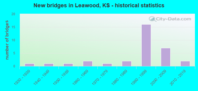
- New bridges - historical statistics
- 11930-1939
- 11940-1949
- 11950-1959
- 21960-1969
- 11970-1979
- 21980-1989
- 161990-1999
- 72000-2009
- 22010-2019

- Reconstructed bridges - Historical Statistics
- 11960-1969
- 11970-1979
- 11980-1989
- 01990-1999
- 12000-2009
- 12010-2019


- Bridge Condition - Deck
- 86.7%Good
- 13.3%Satisfactory

- Bridge Condition - Superstructure
- 40.0%Very good
- 53.3%Good
- 6.7%Satisfactory

- Bridge Condition - Substructure
- 26.7%Very good
- 53.3%Good
- 13.3%Satisfactory
- 6.7%Fair

- Bridge Condition - Channel
- 14.3%Very good
- 57.1%Good
- 25.0%Satisfactory
- 3.6%Fair

- Bridge Condition - Culverts
- 17.6%Very good
- 70.6%Good
- 11.8%Satisfactory
Find on map >> Show street view
Structure Number: 415450462790008, Location: 200 FT E OF WENONGA ROAD (Lat: 38.978700, Lng: -94.620969), Route carried "on" structure: City street 2790, Year Built: 1964, Year Reconstructed: 2007, Status: Open, Structure Length: 1.26m (4.13ft), Average Daily Traffic: 7,610 (year 2010), Truck Traffic: 2%, Average Future Daily Traffic: 13,750 (year 2040), Features Intersected: DYKES BRANCH, Facility Carried by Structure: 83RD STREET
Minimum Vertical Clearance: 30.47m (99.97ft), Kilometerpoint: 0.000, Lanes on structure: 2, Owner: City or Municipal Highway Agency, Approaching Roadway Width: 9.6m (31.5ft), Skew: 2 degrees, Material/Design: Concrete, Design/Construction: Culvert, Number Of Spans In Main Unit: 3, Length of Maximum Span: 5.1m (16.7ft), Curb or Sidewalk Widths: Left: 1.2m (3.9ft), Right: 1.2m (3.9ft)
Condition: Channel: Satisfactory, Culverts: Good, Operating Rating: 32.7 metric tons, Method Used To Determine Operating Rating: Field evaluation and documented engineering judgment, Inventory Rating: 32.7 metric tons, Method Used To Determine Inventory Rating: Field evaluation and documented engineering judgment, Structural Evaluation: Better than present minimum criteria, Waterway Adequacy: Equal to present desirable criteria, Approach Roadway Alignment: Equal to present desirable criteria, Designated Inspection Frequency: Every 24 months, Inspection Date: June 2020, Other Special Inspection Date: October 2020
Find on map >> Show street view
Structure Number: 415450462790016, Location: AT SAGAMORE & OVERBROOK (Lat: 38.978703, Lng: -94.610742), Route carried "on" structure: City street 2790, Year Built: 1996, Status: Open, Structure Length: 0.63m (2.07ft), Average Daily Traffic: 7,610 (year 2010), Truck Traffic: 2%, Average Future Daily Traffic: 14,190 (year 2040), Design Load: HS 20, Features Intersected: TRIB. TO DYKES BRANCH, Facility Carried by Structure: 83RD. STREET
Minimum Vertical Clearance: 30.47m (99.97ft), Kilometerpoint: 0.000, Lanes on structure: 2, Owner: City or Municipal Highway Agency, Approaching Roadway Width: 9.6m (31.5ft), Material/Design: Concrete, Design/Construction: Culvert, Number Of Spans In Main Unit: 2, Length of Maximum Span: 3.0m (9.8ft), Curb or Sidewalk Widths: Left: 1.2m (3.9ft), Right: 1.2m (3.9ft)
Condition: Channel: Good, Culverts: Good, Inventory Rating: 72.4 metric tons, Method Used To Determine Inventory Rating: Load Factor (LF), Structural Evaluation: Better than present minimum criteria, Waterway Adequacy: Equal to present desirable criteria, Approach Roadway Alignment: Equal to present desirable criteria, Designated Inspection Frequency: Every 24 months, Inspection Date: June 2020
Find on map >> Show street view
Structure Number: 415450462790017, Location: AT BELINDER & MEADOW LN. (Lat: 38.978728, Lng: -94.616522), Route carried "on" structure: City street 2790, Year Built: 1996, Status: Open, Structure Length: 0.73m (2.40ft), Average Daily Traffic: 7,610 (year 2010), Truck Traffic: 2%, Average Future Daily Traffic: 13,750 (year 2040), Design Load: HS 20, Features Intersected: TRIB. TO DYKES BRANCH, Facility Carried by Structure: 83RD. STREET
Minimum Vertical Clearance: 30.47m (99.97ft), Kilometerpoint: 0.000, Lanes on structure: 2, Owner: City or Municipal Highway Agency, Approaching Roadway Width: 9.6m (31.5ft), Skew: 4 degrees, Material/Design: Concrete, Design/Construction: Culvert, Number Of Spans In Main Unit: 2, Length of Maximum Span: 3.7m (12.1ft), Curb or Sidewalk Widths: Left: 1.2m (3.9ft), Right: 1.2m (3.9ft)
Condition: Channel: Satisfactory, Culverts: Good, Operating Rating: 92.2 metric tons, Method Used To Determine Operating Rating: Load Factor (LF), Inventory Rating: 55.2 metric tons, Method Used To Determine Inventory Rating: Load Factor (LF), Structural Evaluation: Better than present minimum criteria, Waterway Adequacy: Equal to present desirable criteria, Approach Roadway Alignment: Equal to present desirable criteria, Designated Inspection Frequency: Every 24 months, Inspection Date: June 2020
Find on map >> Show street view
Structure Number: 415450462850013, Location: 200 FT. W. SAGAMORE ST. (Lat: 38.942175, Lng: -94.613031), Route carried "on" structure: City street 2850, Year Built: 1955, Year Reconstructed: 1970, Status: Open, Structure Length: 0.82m (2.69ft), Average Daily Traffic: 11,415 (year 2010), Truck Traffic: 5%, Average Future Daily Traffic: 21,450 (year 2040), Features Intersected: JAMES BRANCH, Facility Carried by Structure: 103RD. STREET
Minimum Vertical Clearance: 30.47m (99.97ft), Kilometerpoint: 0.000, Lanes on structure: 4, Owner: City or Municipal Highway Agency, Approaching Roadway Width: 13.4m (44.0ft), Material/Design: Concrete, Design/Construction: Culvert, Number Of Spans In Main Unit: 2, Length of Maximum Span: 3.7m (12.1ft), Curb or Sidewalk Widths: Left: 1.7m (5.6ft), Right: 1.7m (5.6ft)
Condition: Channel: Good, Culverts: Satisfactory, Operating Rating: 44.4 metric tons, Method Used To Determine Operating Rating: Load Factor (LF), Inventory Rating: 26.8 metric tons, Method Used To Determine Inventory Rating: Load Factor (LF), Structural Evaluation: Equal to present minimum criteria, Waterway Adequacy: Equal to present desirable criteria, Approach Roadway Alignment: Equal to present desirable criteria, Designated Inspection Frequency: Every 24 months, Inspection Date: June 2020
Find on map >> Show street view
Structure Number: 415450462880002, Location: 119TH. ST. & MISSION ROAD (Lat: 38.912933, Lng: -94.632753), Route carried "on" structure: City street 2880, Year Built: 1967, Year Reconstructed: 1987, Status: Open, Structure Length: 4.05m (13.29ft), Average Daily Traffic: 21,060 (year 2010), Truck Traffic: 3%, Average Future Daily Traffic: 24,970 (year 2040), Design Load: HS 20, Features Intersected: TOMAHAWK CREEK, Facility Carried by Structure: 119TH. ST.
Minimum Vertical Clearance: 30.47m (99.97ft), Kilometerpoint: 0.000, Lanes on structure: 4, Owner: City or Municipal Highway Agency, Approaching Roadway Width: 15.2m (49.9ft), Skew: 1 degrees, Material/Design: Steel continuous, Design/Construction: Stringer/Multi-beam, Number Of Spans In Main Unit: 3, Length of Maximum Span: 15.5m (50.9ft), Curb or Sidewalk Widths: Left: 1.2m (3.9ft), Right: 1.2m (3.9ft), Curb-To-Curb Width: 15.2m (49.9ft), Out-to-Out Width: 18.7m (61.4ft)
Condition: Deck: Good, Superstructure: Very good, Substructure: Very good, Channel: Good, Operating Rating: 73.8 metric tons, Method Used To Determine Operating Rating: Load Factor (LF), Inventory Rating: 44.2 metric tons, Method Used To Determine Inventory Rating: Load Factor (LF), Structural Evaluation: Equal to present desirable criteria, Deck Geometry: High priority of corrective action, Waterway Adequacy: Better than present minimum criteria, Approach Roadway Alignment: Equal to present desirable criteria, Designated Inspection Frequency: Every 24 months, Inspection Date: June 2020, Deck Structure Type: Concrete Cast-file-Place, Wearing Surface/Protective System: Wearing Surface: Low Slump Concrete, Deck Protection: Epoxy Coated Reinforcing
Find on map >> Show street view
Structure Number: 415450463025003, Location: ROE AVE. OVER TOMAHAWK (Lat: 38.906078, Lng: -94.639836), Route carried "on" structure: City street 3025, Year Built: 1989, Status: Open, Structure Length: 5.50m (18.04ft), Average Daily Traffic: 11,860 (year 2010), Truck Traffic: 4%, Average Future Daily Traffic: 12,650 (year 2040), Design Load: HS 20, Features Intersected: TOMAHAWK CREEK, Facility Carried by Structure: ROE AVE.
Minimum Vertical Clearance: 30.47m (99.97ft), Kilometerpoint: 0.000, Lanes on structure: 4, Owner: City or Municipal Highway Agency, Approaching Roadway Width: 18.5m (60.7ft), Material/Design: Steel continuous, Design/Construction: Stringer/Multi-beam, Number Of Spans In Main Unit: 3, Length of Maximum Span: 21.0m (68.9ft), Curb or Sidewalk Widths: Left: 1.2m (3.9ft), Right: 1.2m (3.9ft), Curb-To-Curb Width: 18.6m (61.0ft), Out-to-Out Width: 22.1m (72.5ft)
Condition: Deck: Good, Superstructure: Good, Substructure: Satisfactory, Channel: Satisfactory, Operating Rating: 68.1 metric tons, Method Used To Determine Operating Rating: Load Factor (LF), Inventory Rating: 40.8 metric tons, Method Used To Determine Inventory Rating: Load Factor (LF), Structural Evaluation: Equal to present minimum criteria, Deck Geometry: Equal to present minimum criteria, Waterway Adequacy: Equal to present desirable criteria, Approach Roadway Alignment: Equal to present desirable criteria, Designated Inspection Frequency: Every 24 months, Inspection Date: June 2020, Deck Structure Type: Concrete Cast-file-Place, Wearing Surface/Protective System: Wearing Surface: Epoxy Overlay, Deck Protection: Epoxy Coated Reinforcing
Find on map >> Show street view
Structure Number: 415450463051015, Location: 1000' S. OF I-435 (Lat: 38.931083, Lng: -94.629694), Route carried "on" structure: City street 3051, Year Built: 1992, Status: Open, Structure Length: 6.10m (20.01ft), Average Daily Traffic: 10,915 (year 2010), Truck Traffic: 2%, Average Future Daily Traffic: 20,000 (year 2040), Design Load: HS 20, Features Intersected: INDIAN CREEK, Facility Carried by Structure: MISSION RD.
Minimum Vertical Clearance: 5.18m (16.99ft), Kilometerpoint: 0.000, Lanes on structure: 4, Owner: City or Municipal Highway Agency, Approaching Roadway Width: 15.2m (49.9ft), Skew: 2 degrees, Material/Design: Prestressed concrete continuous, Design/Construction: Stringer/Multi-beam, Number Of Spans In Main Unit: 3, Length of Maximum Span: 20.1m (65.9ft), Curb or Sidewalk Widths: Left: 2.4m (7.9ft), Right: 0.0m, Curb-To-Curb Width: 15.2m (49.9ft), Out-to-Out Width: 18.6m (61.0ft)
Condition: Deck: Good, Superstructure: Very good, Substructure: Very good, Channel: Satisfactory, Operating Rating: 74.1 metric tons, Method Used To Determine Operating Rating: Load Factor (LF), Inventory Rating: 44.4 metric tons, Method Used To Determine Inventory Rating: Load Factor (LF), Structural Evaluation: Equal to present desirable criteria, Deck Geometry: High priority of corrective action, Waterway Adequacy: Equal to present desirable criteria, Approach Roadway Alignment: Equal to present minimum criteria, Length Of Structure Improvement: 9.90m (32.48ft), Designated Inspection Frequency: Every 24 months, Inspection Date: June 2020, Bridge Improvement Cost: $9,000, Roadway Improvement Cost: $1,000, Total Project Cost: $11,000, Deck Structure Type: Concrete Cast-file-Place, Wearing Surface/Protective System: Wearing Surface: Low Slump Concrete, Deck Protection: Epoxy Coated Reinforcing
Find on map >> Show street view
Structure Number: 41545046315101, Location: SOUTHBOUND LANE AT I-435 (Lat: 38.938561, Lng: -94.608467), Route carried "on" structure: City street 3151, Year Built: 1995, Status: Open, Structure Length: 8.63m (28.31ft), Average Daily Traffic: 16,710 (year 2010), Truck Traffic: 6%, Average Future Daily Traffic: 19,580 (year 2040), Design Load: HS 20, Features Intersected: INDIAN CREEK, Facility Carried by Structure: STATELINE ROAD
Minimum Vertical Clearance: 9.14m (29.99ft), Kilometerpoint: 0.000, Lanes on structure: 4, Owner: City or Municipal Highway Agency, Approaching Roadway Width: 11.8m (38.7ft), Material/Design: Steel continuous, Design/Construction: Stringer/Multi-beam, Number Of Spans In Main Unit: 5, Length of Maximum Span: 20.1m (65.9ft), Curb-To-Curb Width: 15.5m (50.9ft), Out-to-Out Width: 16.2m (53.1ft)
Condition: Deck: Good, Superstructure: Very good, Substructure: Good, Channel: Good, Operating Rating: 89.8 metric tons, Method Used To Determine Operating Rating: Load Factor (LF), Inventory Rating: 50.6 metric tons, Method Used To Determine Inventory Rating: Load Factor (LF), Structural Evaluation: Better than present minimum criteria, Deck Geometry: Meets minimum limits, Waterway Adequacy: Better than present minimum criteria, Approach Roadway Alignment: Equal to present desirable criteria, Length Of Structure Improvement: 9.90m (32.48ft), Designated Inspection Frequency: Every 24 months, Inspection Date: June 2020, Bridge Improvement Cost: $9,000, Roadway Improvement Cost: $1,000, Total Project Cost: $11,000, Deck Structure Type: Concrete Cast-file-Place, Wearing Surface/Protective System: Wearing Surface: Low Slump Concrete
Find on map >> Show street view
Structure Number: 415450463151011, Location: NORTHBOUND LANE AT I-435 (Lat: 38.938739, Lng: -94.608178), Route carried "on" structure: City street 3151, Year Built: 1995, Status: Open, Structure Length: 8.63m (28.31ft), Average Daily Traffic: 16,710 (year 2010), Truck Traffic: 6%, Average Future Daily Traffic: 22,000 (year 2040), Design Load: HS 20, Features Intersected: INDIAN CREEK, Facility Carried by Structure: STATELINE ROAD
Minimum Vertical Clearance: 9.14m (29.99ft), Kilometerpoint: 0.000, Lanes on structure: 4, Owner: City or Municipal Highway Agency, Approaching Roadway Width: 11.8m (38.7ft), Material/Design: Steel continuous, Design/Construction: Stringer/Multi-beam, Number Of Spans In Main Unit: 5, Length of Maximum Span: 20.1m (65.9ft), Curb or Sidewalk Widths: Left: 0.0m, Right: 2.4m (7.9ft), Curb-To-Curb Width: 15.5m (50.9ft), Out-to-Out Width: 19.1m (62.7ft)
Condition: Deck: Good, Superstructure: Very good, Substructure: Good, Channel: Good, Operating Rating: 63.9 metric tons, Method Used To Determine Operating Rating: Load Factor (LF), Inventory Rating: 38.2 metric tons, Method Used To Determine Inventory Rating: Load Factor (LF), Structural Evaluation: Better than present minimum criteria, Deck Geometry: Meets minimum limits, Waterway Adequacy: Better than present minimum criteria, Approach Roadway Alignment: Equal to present desirable criteria, Length Of Structure Improvement: 9.90m (32.48ft), Designated Inspection Frequency: Every 24 months, Inspection Date: June 2020, Bridge Improvement Cost: $9,000, Roadway Improvement Cost: $1,000, Total Project Cost: $11,000, Deck Structure Type: Concrete Cast-file-Place, Wearing Surface/Protective System: Wearing Surface: Low Slump Concrete
Find on map >> Show street view
Structure Number: 415450463151014, Location: 500 FT. S. OF 89TH. ST. (Lat: 38.965497, Lng: -94.608125), Route carried "on" structure: City street 3151, Year Built: 1935, Year Reconstructed: 1967, Status: Open, Structure Length: 1.22m (4.00ft), Average Daily Traffic: 27,375 (year 2010), Truck Traffic: 5%, Average Future Daily Traffic: 33,440 (year 2040), Features Intersected: DYKES BRANCH, Facility Carried by Structure: STATE LINE ROAD
Minimum Vertical Clearance: 30.47m (99.97ft), Kilometerpoint: 0.000, Lanes on structure: 4, Owner: City or Municipal Highway Agency, Approaching Roadway Width: 16.1m (52.8ft), Skew: 10 degrees, Material/Design: Concrete, Design/Construction: Culvert, Number Of Spans In Main Unit: 1, Length of Maximum Span: 12.2m (40.0ft), Curb or Sidewalk Widths: Left: 0.0m, Right: 1.5m (4.9ft)
Condition: Channel: Good, Culverts: Satisfactory, Operating Rating: 32.7 metric tons, Method Used To Determine Operating Rating: Field evaluation and documented engineering judgment, Inventory Rating: 32.7 metric tons, Method Used To Determine Inventory Rating: Field evaluation and documented engineering judgment, Structural Evaluation: Equal to present minimum criteria, Waterway Adequacy: Equal to present desirable criteria, Approach Roadway Alignment: Equal to present desirable criteria, Designated Inspection Frequency: Every 24 months, Inspection Date: June 2020, Other Special Inspection Date: October 2020
Find on map >> Show street view
Structure Number: 415450463151032, Location: 430ft S of 86th TERR (Lat: 38.970811, Lng: -94.608189), Route carried "on" structure: City street 3151, Year Built: 1970, Status: Open, Structure Length: 0.73m (2.40ft), Average Daily Traffic: 27,375 (year 2016), Truck Traffic: 5%, Average Future Daily Traffic: 27,375 (year 2040), Features Intersected: PARKING LOT ACCESS RD, Facility Carried by Structure: STATE LINE RD
Minimum Vertical Clearance: 30.47m (99.97ft), Kilometerpoint: 0.000, Lanes on structure: 4, Lanes under structure: 2, Owner: City or Municipal Highway Agency, Approaching Roadway Width: 14.9m (48.9ft), Skew: 20 degrees, Material/Design: Concrete, Design/Construction: Culvert, Number Of Spans In Main Unit: 1, Length of Maximum Span: 7.3m (24.0ft), Curb or Sidewalk Widths: Left: 1.2m (3.9ft), Right: 1.8m (5.9ft)
Condition: Culverts: Good, Operating Rating: 32.7 metric tons, Method Used To Determine Operating Rating: Field evaluation and documented engineering judgment, Inventory Rating: 32.7 metric tons, Method Used To Determine Inventory Rating: Field evaluation and documented engineering judgment, Structural Evaluation: Better than present minimum criteria, Underclear: High priority of corrective action, Approach Roadway Alignment: Equal to present desirable criteria, Designated Inspection Frequency: Every 24 months, Inspection Date: June 2020, Other Special Inspection Date: October 2020, Wearing Surface/Protective System: Wearing Surface: Bituminous
Find on map >> Show street view
Structure Number: 515450460000005, Location: 200 FT S OF 86TH TERR (Lat: 38.971394, Lng: -94.614386), Route carried "on" structure: City street , Year Built: 1940, Status: Open, Structure Length: 0.69m (2.26ft), Average Daily Traffic: 6,580 (year 2010), Truck Traffic: 1%, Average Future Daily Traffic: 10,120 (year 2040), Features Intersected: DYKES BRANCH, Facility Carried by Structure: LEE BOULEVARD
Minimum Vertical Clearance: 30.47m (99.97ft), Kilometerpoint: 0.000, Lanes on structure: 2, Owner: City or Municipal Highway Agency, Approaching Roadway Width: 8.8m (28.9ft), Material/Design: Concrete, Design/Construction: Slab, Number Of Spans In Main Unit: 1, Length of Maximum Span: 6.1m (20.0ft), Curb or Sidewalk Widths: Left: 1.8m (5.9ft), Right: 0.0m, Curb-To-Curb Width: 10.7m (35.1ft), Out-to-Out Width: 14.0m (45.9ft)
Condition: Deck: Satisfactory, Superstructure: Satisfactory, Substructure: Fair, Channel: Fair, Operating Rating: 32.7 metric tons, Method Used To Determine Operating Rating: Field evaluation and documented engineering judgment, Inventory Rating: 32.7 metric tons, Method Used To Determine Inventory Rating: Field evaluation and documented engineering judgment, Structural Evaluation: Somewhat better than minimum adequacy, Deck Geometry: Meets minimum limits, Waterway Adequacy: Equal to present minimum criteria, Approach Roadway Alignment: Equal to present desirable criteria, Designated Inspection Frequency: Every 24 months, Inspection Date: June 2020, Other Special Inspection Date: October 2020, Deck Structure Type: Concrete Cast-file-Place, Wearing Surface/Protective System: Wearing Surface: Bituminous
Find on map >> Show street view
Structure Number: 515450460000006, Location: 150 FT. W. BELINDER RD. (Lat: 38.973406, Lng: -94.618400), Route carried "on" structure: City street , Year Built: 2005, Status: Open, Structure Length: 2.03m (6.66ft), Average Daily Traffic: 1,200 (year 2006), Truck Traffic: 1%, Average Future Daily Traffic: 1,320 (year 2040), Design Load: HS 20, Features Intersected: DYKES BRANCH, Facility Carried by Structure: 86TH. STREET
Minimum Vertical Clearance: 30.47m (99.97ft), Kilometerpoint: 0.000, Lanes on structure: 2, Owner: City or Municipal Highway Agency, Approaching Roadway Width: 7.5m (24.6ft), Material/Design: Concrete continuous, Design/Construction: Slab, Number Of Spans In Main Unit: 2, Length of Maximum Span: 9.7m (31.8ft), Curb-To-Curb Width: 7.6m (24.9ft), Out-to-Out Width: 8.2m (26.9ft)
Condition: Deck: Good, Superstructure: Good, Substructure: Good, Channel: Good, Inventory Rating: 92.1 metric tons, Method Used To Determine Inventory Rating: Load Factor (LF), Structural Evaluation: Better than present minimum criteria, Deck Geometry: Meets minimum limits, Waterway Adequacy: Equal to present desirable criteria, Approach Roadway Alignment: Equal to present minimum criteria, Designated Inspection Frequency: Every 24 months, Inspection Date: June 2020, Deck Structure Type: Concrete Cast-file-Place, Wearing Surface/Protective System: Deck Protection: Epoxy Coated Reinforcing
Find on map >> Show street view
Structure Number: 515450460000007, Location: 150 FT N OF 82ND TERRACE (Lat: 38.979781, Lng: -94.621725), Route carried "on" structure: City street , Year Built: 2007, Status: Open, Structure Length: 1.50m (4.92ft), Average Daily Traffic: 1,300 (year 2010), Truck Traffic: 2%, Average Future Daily Traffic: 1,500 (year 2040), Design Load: HS 20, Features Intersected: DYKES BRANCH, Facility Carried by Structure: WENONGA ROAD
Minimum Vertical Clearance: 30.47m (99.97ft), Kilometerpoint: 0.000, Lanes on structure: 2, Owner: City or Municipal Highway Agency, Approaching Roadway Width: 7.6m (24.9ft), Skew: 1 degrees, Material/Design: Concrete, Design/Construction: Culvert, Number Of Spans In Main Unit: 3, Length of Maximum Span: 4.7m (15.4ft), Curb-To-Curb Width: 7.6m (24.9ft), Out-to-Out Width: 8.4m (27.6ft)
Condition: Channel: Very good, Culverts: Good, Operating Rating: 89.6 metric tons, Method Used To Determine Operating Rating: Load Factor (LF), Inventory Rating: 53.7 metric tons, Method Used To Determine Inventory Rating: Load Factor (LF), Structural Evaluation: Better than present minimum criteria, Deck Geometry: Meets minimum limits, Waterway Adequacy: Equal to present desirable criteria, Approach Roadway Alignment: Equal to present desirable criteria, Designated Inspection Frequency: Every 24 months, Inspection Date: June 2020
Find on map >> Show street view
Structure Number: 515450460000009, Location: 85TH TERR AT HIGH DRIVE (Lat: 38.974289, Lng: -94.613194), Route carried "on" structure: City street , Year Built: 1994, Status: Open, Structure Length: 1.34m (4.40ft), Average Daily Traffic: 2,500 (year 2005), Truck Traffic: 2%, Average Future Daily Traffic: 2,750 (year 2040), Design Load: HS 20, Features Intersected: TRIB. TO DYKES BRANCH, Facility Carried by Structure: 85TH TERRACE
Minimum Vertical Clearance: 30.47m (99.97ft), Kilometerpoint: 0.000, Lanes on structure: 2, Owner: City or Municipal Highway Agency, Approaching Roadway Width: 7.0m (23.0ft), Skew: 1 degrees, Material/Design: Concrete, Design/Construction: Slab, Number Of Spans In Main Unit: 1, Length of Maximum Span: 11.6m (38.1ft), Curb or Sidewalk Widths: Left: 2.8m (9.2ft), Right: 0.0m, Curb-To-Curb Width: 7.0m (23.0ft), Out-to-Out Width: 10.5m (34.4ft)
Condition: Deck: Good, Superstructure: Good, Substructure: Very good, Channel: Good, Operating Rating: 32.7 metric tons, Method Used To Determine Operating Rating: Field evaluation and documented engineering judgment, Inventory Rating: 32.7 metric tons, Method Used To Determine Inventory Rating: Field evaluation and documented engineering judgment, Structural Evaluation: Better than present minimum criteria, Deck Geometry: High priority of replacement, Waterway Adequacy: Better than present minimum criteria, Approach Roadway Alignment: Equal to present desirable criteria, Designated Inspection Frequency: Every 24 months, Inspection Date: June 2020, Other Special Inspection Date: October 2020, Deck Structure Type: Concrete Cast-file-Place
Find on map >> Show street view
Structure Number: 515450460000018, Location: BETWEEN 143RD. & 151ST. (Lat: 38.863475, Lng: -94.630522), Route carried "on" structure: City street , Year Built: 1995, Status: Open, Structure Length: 0.66m (2.17ft), Average Daily Traffic: 5,530 (year 2010), Truck Traffic: 3%, Average Future Daily Traffic: 6,000 (year 2040), Design Load: HS 20, Features Intersected: TRIB. TO NEGRO CREEK, Facility Carried by Structure: MISSION RD.
Minimum Vertical Clearance: 30.47m (99.97ft), Kilometerpoint: 0.000, Lanes on structure: 2, Owner: City or Municipal Highway Agency, Approaching Roadway Width: 7.0m (23.0ft), Skew: 1 degrees, Material/Design: Concrete, Design/Construction: Culvert, Number Of Spans In Main Unit: 2, Length of Maximum Span: 3.2m (10.5ft), Curb or Sidewalk Widths: Left: 0.0m, Right: 1.2m (3.9ft)
Condition: Channel: Good, Culverts: Good, Operating Rating: 71.9 metric tons, Method Used To Determine Operating Rating: Load Factor (LF), Inventory Rating: 43.1 metric tons, Method Used To Determine Inventory Rating: Load Factor (LF), Structural Evaluation: Better than present minimum criteria, Waterway Adequacy: Better than present minimum criteria, Approach Roadway Alignment: Equal to present desirable criteria, Designated Inspection Frequency: Every 24 months, Inspection Date: June 2020
Find on map >> Show street view
Structure Number: 515450460000019, Location: BETWEEN BELL DR. & 151ST. (Lat: 38.851908, Lng: -94.630461), Route carried "on" structure: City street , Year Built: 1995, Status: Open, Structure Length: 1.74m (5.71ft), Average Daily Traffic: 4,815 (year 2010), Truck Traffic: 3%, Average Future Daily Traffic: 5,000 (year 2040), Features Intersected: TRIB. TO NEGRO CREEK, Facility Carried by Structure: MISSION RD.
Minimum Vertical Clearance: 6.09m (19.98ft), Kilometerpoint: 0.000, Lanes on structure: 3, Owner: City or Municipal Highway Agency, Approaching Roadway Width: 10.9m (35.8ft), Material/Design: Concrete, Design/Construction: Culvert, Number Of Spans In Main Unit: 3, Length of Maximum Span: 6.1m (20.0ft), Curb or Sidewalk Widths: Left: 1.2m (3.9ft), Right: 1.2m (3.9ft)
Condition: Channel: Good, Culverts: Good, Inventory Rating: 95.8 metric tons, Method Used To Determine Inventory Rating: Load Factor (LF), Structural Evaluation: Better than present minimum criteria, Waterway Adequacy: Equal to present desirable criteria, Approach Roadway Alignment: Equal to present desirable criteria, Designated Inspection Frequency: Every 24 months, Inspection Date: June 2020
Find on map >> Show street view
Structure Number: 51545046000002, Location: College Bvd. and Mission (Lat: 38.927789, Lng: -94.622872), Route carried "on" structure: City street , Year Built: 1996, Status: Open, Structure Length: 21.15m (69.39ft), Average Daily Traffic: 9,900 (year 2010), Truck Traffic: 3%, Average Future Daily Traffic: 12,500 (year 2040), Design Load: HS 20+Mod, Features Intersected: TOMAHAWK CREEK, Facility Carried by Structure: COLLEGE BOULEVARD
Minimum Vertical Clearance: 30.47m (99.97ft), Kilometerpoint: 0.000, Lanes on structure: 4, Owner: City or Municipal Highway Agency, Approaching Roadway Width: 17.0m (55.8ft), Skew: 9 degrees, Material/Design: Concrete continuous, Design/Construction: Slab, Number Of Spans In Main Unit: 9, Length of Maximum Span: 24.4m (80.1ft), Curb or Sidewalk Widths: Left: 2.4m (7.9ft), Right: 0.0m, Curb-To-Curb Width: 17.1m (56.1ft), Out-to-Out Width: 20.5m (67.3ft)
Condition: Deck: Good, Superstructure: Good, Substructure: Good, Channel: Good, Operating Rating: 36.6 metric tons, Method Used To Determine Operating Rating: Load Factor (LF), Inventory Rating: 21.9 metric tons, Method Used To Determine Inventory Rating: Load Factor (LF), Structural Evaluation: Somewhat better than minimum adequacy, Deck Geometry: Somewhat better than minimum adequacy, Waterway Adequacy: Equal to present desirable criteria, Approach Roadway Alignment: Somewhat better than minimum adequacy, Designated Inspection Frequency: Every 24 months, Inspection Date: June 2020, Deck Structure Type: Concrete Cast-file-Place, Wearing Surface/Protective System: Deck Protection: Epoxy Coated Reinforcing
Find on map >> Show street view
Structure Number: 515450460000024, Location: 100FT W OF GRANADA RD. (Lat: 38.869247, Lng: -94.637919), Route carried "on" structure: City street , Year Built: 2000, Year Reconstructed: 2016, Status: Open, Structure Length: 0.78m (2.56ft), Average Daily Traffic: 5,850 (year 2010), Truck Traffic: 3%, Average Future Daily Traffic: 6,000 (year 2040), Design Load: HS 20, Features Intersected: TRIB. TO NEGRO CREEK, Facility Carried by Structure: 143RD ST.
Minimum Vertical Clearance: 30.47m (99.97ft), Kilometerpoint: 0.000, Lanes on structure: 4, Owner: City or Municipal Highway Agency, Approaching Roadway Width: 16.6m (54.5ft), Material/Design: Concrete, Design/Construction: Culvert, Number Of Spans In Main Unit: 2, Length of Maximum Span: 3.7m (12.1ft), Curb or Sidewalk Widths: Left: 2.9m (9.5ft), Right: 1.7m (5.6ft)
Condition: Channel: Good, Culverts: Good, Operating Rating: 79.8 metric tons, Method Used To Determine Operating Rating: Load Factor (LF), Inventory Rating: 47.8 metric tons, Method Used To Determine Inventory Rating: Load Factor (LF), Structural Evaluation: Better than present minimum criteria, Waterway Adequacy: Equal to present desirable criteria, Approach Roadway Alignment: Equal to present desirable criteria, Designated Inspection Frequency: Every 24 months, Inspection Date: June 2020
Find on map >> Show street view
Structure Number: 515450460000025, Location: At 117TH ST. (Lat: 38.916731, Lng: -94.633842), Route carried "on" structure: City street , Year Built: 1988, Status: Open, Structure Length: 1.17m (3.84ft), Average Daily Traffic: 10,000 (year 2010), Truck Traffic: 3%, Average Future Daily Traffic: 11,000 (year 2040), Design Load: HS 20, Features Intersected: TRIB. TO TOMAHAWK CREEK, Facility Carried by Structure: TOMAHAWK CK PKWY
Minimum Vertical Clearance: 30.47m (99.97ft), Kilometerpoint: 0.000, Lanes on structure: 5, Owner: City or Municipal Highway Agency, Approaching Roadway Width: 18.0m (59.1ft), Skew: 10 degrees, Material/Design: Concrete, Design/Construction: Culvert, Number Of Spans In Main Unit: 4, Length of Maximum Span: 3.0m (9.8ft), Curb or Sidewalk Widths: Left: 1.2m (3.9ft), Right: 0.0m
Condition: Channel: Satisfactory, Culverts: Good, Inventory Rating: 65.3 metric tons, Method Used To Determine Inventory Rating: Load Factor (LF), Structural Evaluation: Better than present minimum criteria, Waterway Adequacy: Equal to present desirable criteria, Approach Roadway Alignment: Equal to present desirable criteria, Designated Inspection Frequency: Every 24 months, Inspection Date: June 2020
Find on map >> Show street view
Structure Number: 515450460000026, Location: At 86th St. (Lat: 38.972222, Lng: -94.620131), Route carried "on" structure: City street , Year Built: 2000, Status: Open, Structure Length: 0.69m (2.26ft), Average Daily Traffic: 1,300 (year 2005), Truck Traffic: 3%, Average Future Daily Traffic: 1,500 (year 2040), Design Load: HS 20, Features Intersected: Dyke Branch Trib., Facility Carried by Structure: Overhill Rd.
Minimum Vertical Clearance: 30.47m (99.97ft), Kilometerpoint: 0.000, Lanes on structure: 2, Owner: City or Municipal Highway Agency, Approaching Roadway Width: 7.6m (24.9ft), Material/Design: Concrete, Design/Construction: Culvert, Number Of Spans In Main Unit: 2, Length of Maximum Span: 3.4m (11.2ft)
Condition: Channel: Very good, Culverts: Good, Operating Rating: 61.3 metric tons, Method Used To Determine Operating Rating: Load Factor (LF), Inventory Rating: 36.7 metric tons, Method Used To Determine Inventory Rating: Load Factor (LF), Structural Evaluation: Better than present minimum criteria, Waterway Adequacy: Equal to present desirable criteria, Approach Roadway Alignment: Equal to present desirable criteria, Designated Inspection Frequency: Every 24 months, Inspection Date: June 2020
Find on map >> Show street view
Structure Number: 515450460000027, Location: At High Dr. (Lat: 38.887464, Lng: -94.614861), Route carried "on" structure: City street , Year Built: 2001, Status: Open, Structure Length: 1.17m (3.84ft), Average Daily Traffic: 2,500 (year 2010), Truck Traffic: 3%, Average Future Daily Traffic: 3,000 (year 2040), Design Load: HS 20, Features Intersected: Storm Drainage, Facility Carried by Structure: 133RD STREET
Minimum Vertical Clearance: 30.47m (99.97ft), Kilometerpoint: 0.000, Lanes on structure: 2, Owner: City or Municipal Highway Agency, Approaching Roadway Width: 10.6m (34.8ft), Skew: 4 degrees, Material/Design: Concrete, Design/Construction: Culvert, Number Of Spans In Main Unit: 2, Length of Maximum Span: 5.5m (18.0ft), Curb or Sidewalk Widths: Left: 0.0m, Right: 1.8m (5.9ft)
Condition: Channel: Satisfactory, Culverts: Very good, Operating Rating: 32.7 metric tons, Method Used To Determine Operating Rating: Field evaluation and documented engineering judgment, Inventory Rating: 32.7 metric tons, Method Used To Determine Inventory Rating: Field evaluation and documented engineering judgment, Structural Evaluation: Equal to present desirable criteria, Waterway Adequacy: Equal to present desirable criteria, Approach Roadway Alignment: Equal to present desirable criteria, Designated Inspection Frequency: Every 24 months, Inspection Date: June 2020, Other Special Inspection Date: October 2020
Find on map >> Show street view
Structure Number: 515450460000028, Location: At Stateline (Lat: 38.976981, Lng: -94.609172), Route carried "on" structure: City street , Year Built: 2000, Status: Open, Structure Length: 0.64m (2.10ft), Average Daily Traffic: 100 (year 2010), Truck Traffic: 3%, Average Future Daily Traffic: 150 (year 2040), Design Load: HS 20, Features Intersected: Storm Drainage, Facility Carried by Structure: 84th St.
Minimum Vertical Clearance: 30.47m (99.97ft), Kilometerpoint: 0.000, Lanes on structure: 2, Owner: City or Municipal Highway Agency, Approaching Roadway Width: 7.6m (24.9ft), Skew: 1 degrees, Material/Design: Concrete, Design/Construction: Culvert, Number Of Spans In Main Unit: 2, Length of Maximum Span: 3.0m (9.8ft)
Condition: Channel: Good, Culverts: Good, Operating Rating: 32.7 metric tons, Method Used To Determine Operating Rating: Field evaluation and documented engineering judgment, Inventory Rating: 32.7 metric tons, Method Used To Determine Inventory Rating: Field evaluation and documented engineering judgment, Structural Evaluation: Better than present minimum criteria, Waterway Adequacy: Equal to present desirable criteria, Approach Roadway Alignment: Equal to present desirable criteria, Designated Inspection Frequency: Every 24 months, Inspection Date: June 2020, Other Special Inspection Date: October 2020
Find on map >> Show street view
Structure Number: 515450460000029, Location: 550 ft N of 143rd St (Lat: 38.871028, Lng: -94.644028), Route carried "on" structure: City street , Year Built: 2007, Status: Open, Structure Length: 0.62m (2.03ft), Average Daily Traffic: 500 (year 2007), Average Future Daily Traffic: 600 (year 2040), Design Load: HS 25 or greater, Features Intersected: Storm Drainage, Facility Carried by Structure: Juniper Street
Minimum Vertical Clearance: 30.47m (99.97ft), Kilometerpoint: 0.000, Lanes on structure: 2, Owner: City or Municipal Highway Agency, Approaching Roadway Width: 7.9m (25.9ft), Skew: 1 degrees, Material/Design: Concrete, Design/Construction: Culvert, Number Of Spans In Main Unit: 1, Length of Maximum Span: 6.2m (20.3ft), Curb or Sidewalk Widths: Left: 0.0m, Right: 1.2m (3.9ft)
Condition: Channel: Good, Culverts: Good, Operating Rating: 32.7 metric tons, Method Used To Determine Operating Rating: Field evaluation and documented engineering judgment, Inventory Rating: 32.7 metric tons, Method Used To Determine Inventory Rating: Field evaluation and documented engineering judgment, Structural Evaluation: Better than present minimum criteria, Waterway Adequacy: Equal to present desirable criteria, Approach Roadway Alignment: Equal to present desirable criteria, Designated Inspection Frequency: Every 24 months, Inspection Date: June 2020, Other Special Inspection Date: October 2020
Find on map >> Show street view
Structure Number: 51545046000003, Location: 180ft N of 88th ST (Lat: 38.969219, Lng: -94.624439), Route carried "on" structure: Other road 1235, Year Built: 2016, Status: Open, Structure Length: 0.65m (2.13ft), Average Daily Traffic: 400 (year 2016), Average Future Daily Traffic: 400 (year 2040), Design Load: HL 93, Features Intersected: TRIB. TO DYKES BRANCH, Facility Carried by Structure: CHEROKEE LANE
Minimum Vertical Clearance: 30.47m (99.97ft), Kilometerpoint: 0.000, Lanes on structure: 2, Owner: City or Municipal Highway Agency, Approaching Roadway Width: 7.3m (24.0ft), Material/Design: Concrete, Design/Construction: Culvert, Number Of Spans In Main Unit: 2, Length of Maximum Span: 3.0m (9.8ft)
Condition: Channel: Very good, Culverts: Very good, Operating Rating: 53.5 metric tons, Method Used To Determine Operating Rating: Load and Resistance Factor Rating (LRFR) rating reported by rating factor(RF) method using HL-93 loadings, Inventory Rating: 41.1 metric tons, Method Used To Determine Inventory Rating: Load and Resistance Factor Rating (LRFR) rating reported by rating factor(RF) method using HL-93 loadings, Structural Evaluation: Equal to present desirable criteria, Waterway Adequacy: Equal to present desirable criteria, Approach Roadway Alignment: Equal to present desirable criteria, Designated Inspection Frequency: Every 24 months, Inspection Date: June 2020, Other Special Inspection Date: October 2020
Find on map >> Show street view
Structure Number: 515450460000031, Location: 450ft N of 88th ST (Lat: 38.970961, Lng: -94.621989), Route carried "on" structure: Other road 19175, Year Built: 2016, Status: Open, Structure Length: 1.16m (3.81ft), Average Daily Traffic: 400 (year 2016), Average Future Daily Traffic: 400 (year 2040), Design Load: HL 93, Features Intersected: TRIB. TO DYKES BRANCH, Facility Carried by Structure: ENSLEY LANE
Minimum Vertical Clearance: 30.47m (99.97ft), Kilometerpoint: 0.000, Lanes on structure: 2, Owner: City or Municipal Highway Agency, Approaching Roadway Width: 7.3m (24.0ft), Skew: 6 degrees, Material/Design: Concrete, Design/Construction: Culvert, Number Of Spans In Main Unit: 2, Length of Maximum Span: 5.1m (16.7ft)
Condition: Channel: Very good, Culverts: Very good, Operating Rating: 78.7 metric tons, Method Used To Determine Operating Rating: Load and Resistance Factor Rating (LRFR) rating reported by rating factor(RF) method using HL-93 loadings, Inventory Rating: 60.9 metric tons, Method Used To Determine Inventory Rating: Load and Resistance Factor Rating (LRFR) rating reported by rating factor(RF) method using HL-93 loadings, Structural Evaluation: Equal to present desirable criteria, Waterway Adequacy: Equal to present desirable criteria, Approach Roadway Alignment: Equal to present desirable criteria, Designated Inspection Frequency: Every 24 months, Inspection Date: June 2020, Other Special Inspection Date: October 2020
Find on map >> Show street view
Structure Number: 999943500463091, Location: 0.69 MI W OF STATE LINE (Lat: 38.933333, Lng: -94.619722), Route carried "on" structure: ServiceCity street 3113, Year Built: 1996, Status: Open, Structure Length: 8.37m (27.46ft), Average Daily Traffic: 881 (year 2020), Truck Traffic: 1%, Average Future Daily Traffic: 93,870 (year 2041), Design Load: HS 20, Features Intersected: I-435 HWY, NL-SL, Facility Carried by Structure: LEE BLVD
Minimum Vertical Clearance: 30.47m (99.97ft), Kilometerpoint: 0.980, Lanes on structure: 2, Lanes under structure: 10, Owner: State Highway Agency, Approaching Roadway Width: 9.8m (32.2ft), Material/Design: Steel continuous, Design/Construction: Stringer/Multi-beam, Number Of Spans In Main Unit: 4, Length of Maximum Span: 25.9m (85.0ft), Curb or Sidewalk Widths: Left: 1.5m (4.9ft), Right: 0.0m, Curb-To-Curb Width: 10.7m (35.1ft), Out-to-Out Width: 13.3m (43.6ft)
Condition: Deck: Good, Superstructure: Good, Substructure: Good, Operating Rating: 62.1 metric tons, Method Used To Determine Operating Rating: Load Factor (LF), Inventory Rating: 37.2 metric tons, Method Used To Determine Inventory Rating: Load Factor (LF), Structural Evaluation: Better than present minimum criteria, Deck Geometry: Equal to present minimum criteria, Underclear: Meets minimum limits, Approach Roadway Alignment: Somewhat better than minimum adequacy, Length Of Structure Improvement: 27.45m (90.06ft), Designated Inspection Frequency: Every 24 months, Inspection Date: May 2020, Wearing Surface/Protective System: Wearing Surface: Low Slump Concrete, Deck Protection: Epoxy Coated Reinforcing
Find on map >> Show street view
Structure Number: 999943500463101, Location: 0.26 MI W OF STATE LINE (Lat: 38.935556, Lng: -94.611944), Route carried "on" structure: Interstate 435, Year Built: 1994, Status: Open, Structure Length: 7.77m (25.49ft), Average Daily Traffic: 67,801 (year 2020), Truck Traffic: 5%, Average Future Daily Traffic: 87,786 (year 2041), Design Load: HS 25 or greater, Features Intersected: INDIAN CREEK
Minimum Vertical Clearance: 30.47m (99.97ft), Kilometerpoint: 0.386, Lanes on structure: 4, Base Highway Network: Yes, Owner: State Highway Agency, Approaching Roadway Width: 23.2m (76.1ft), Skew: 3 degrees, Material/Design: Prestressed concrete continuous, Design/Construction: Stringer/Multi-beam, Number Of Spans In Main Unit: 5, Length of Maximum Span: 17.1m (56.1ft), Curb-To-Curb Width: 23.2m (76.1ft), Out-to-Out Width: 24.0m (78.7ft)
Condition: Deck: Good, Superstructure: Very good, Substructure: Good, Channel: Good, Operating Rating: 71.0 metric tons, Method Used To Determine Operating Rating: Load Factor (LF), Inventory Rating: 38.0 metric tons, Method Used To Determine Inventory Rating: Load Factor (LF), Structural Evaluation: Better than present minimum criteria, Deck Geometry: Superior to present desirable criteria, Waterway Adequacy: Better than present minimum criteria, Approach Roadway Alignment: Equal to present desirable criteria, Length Of Structure Improvement: 25.48m (83.60ft), Designated Inspection Frequency: Every 24 months, Inspection Date: May 2020, Wearing Surface/Protective System: Wearing Surface: Low Slump Concrete, Deck Protection: Epoxy Coated Reinforcing
Find on map >> Show street view
Structure Number: 999943500463111, Location: 0.26 MI W OF STATE LINE (Lat: 38.935833, Lng: -94.611944), Route carried "on" structure: Interstate 435, Year Built: 1994, Status: Open, Structure Length: 7.77m (25.49ft), Average Daily Traffic: 67,801 (year 2020), Truck Traffic: 5%, Average Future Daily Traffic: 87,786 (year 2041), Design Load: HS 25 or greater, Features Intersected: INDIAN CREEK
Minimum Vertical Clearance: 30.47m (99.97ft), Kilometerpoint: 0.381, Lanes on structure: 6, Base Highway Network: Yes, Owner: State Highway Agency, Approaching Roadway Width: 27.4m (89.9ft), Skew: 3 degrees, Material/Design: Prestressed concrete continuous, Design/Construction: Stringer/Multi-beam, Number Of Spans In Main Unit: 5, Length of Maximum Span: 17.1m (56.1ft), Curb-To-Curb Width: 27.4m (89.9ft), Out-to-Out Width: 28.3m (92.8ft)
Condition: Deck: Good, Superstructure: Very good, Substructure: Good, Channel: Good, Operating Rating: 70.7 metric tons, Method Used To Determine Operating Rating: Load Factor (LF), Inventory Rating: 37.9 metric tons, Method Used To Determine Inventory Rating: Load Factor (LF), Structural Evaluation: Better than present minimum criteria, Deck Geometry: Equal to present minimum criteria, Waterway Adequacy: Better than present minimum criteria, Approach Roadway Alignment: Equal to present desirable criteria, Length Of Structure Improvement: 25.48m (83.60ft), Designated Inspection Frequency: Every 24 months, Inspection Date: May 2020, Wearing Surface/Protective System: Wearing Surface: Low Slump Concrete, Deck Protection: Epoxy Coated Reinforcing
Find on map >> Show street view
Structure Number: 999943500463121, Location: 0.27 MI W OF STATE LINE (Lat: 38.935000, Lng: -94.611944), Route carried "on" structure: Ramp State highway 55, Year Built: 1994, Status: Open, Structure Length: 7.22m (23.69ft), Average Daily Traffic: 14,885 (year 2020), Truck Traffic: 5%, Average Future Daily Traffic: 93,870 (year 2041), Design Load: HS 25 or greater, Features Intersected: INDIAN CREEK, Facility Carried by Structure: I-435 RAMP EB-SB
Minimum Vertical Clearance: 30.47m (99.97ft), Kilometerpoint: 0.172, Lanes on structure: 2, Owner: State Highway Agency, Approaching Roadway Width: 11.6m (38.1ft), Skew: 2 degrees, Material/Design: Concrete, Design/Construction: Slab, Number Of Spans In Main Unit: 5, Length of Maximum Span: 15.8m (51.8ft), Curb-To-Curb Width: 11.6m (38.1ft), Out-to-Out Width: 12.4m (40.7ft)
Condition: Deck: Good, Superstructure: Good, Substructure: Very good, Channel: Satisfactory, Operating Rating: 66.9 metric tons, Method Used To Determine Operating Rating: Load Factor (LF), Inventory Rating: 40.0 metric tons, Method Used To Determine Inventory Rating: Load Factor (LF), Structural Evaluation: Better than present minimum criteria, Deck Geometry: Superior to present desirable criteria, Waterway Adequacy: Better than present minimum criteria, Approach Roadway Alignment: Equal to present desirable criteria, Length Of Structure Improvement: 23.68m (77.69ft), Designated Inspection Frequency: Every 24 months, Inspection Date: May 2020, Wearing Surface/Protective System: Wearing Surface: Monolithic Concrete, Deck Protection: Epoxy Coated Reinforcing
Find on map >> Show street view
Structure Number: 999943500463131, Location: JCT STATE LINE / I-435 (Lat: 38.936667, Lng: -94.607778), Route carried "on" structure: Interstate 435, Year Built: 1995, Status: Open, Structure Length: 7.40m (24.28ft), Average Daily Traffic: 67,801 (year 2020), Truck Traffic: 5%, Average Future Daily Traffic: 87,786 (year 2041), Design Load: HS 25 or greater, Features Intersected: STATE LINE ROAD
Minimum Vertical Clearance: 30.47m (99.97ft), Kilometerpoint: 0.023, Lanes on structure: 5, Lanes under structure: 6, Base Highway Network: Yes, Owner: State Highway Agency, Approaching Roadway Width: 23.8m (78.1ft), Skew: 2 degrees, Material/Design: Steel continuous, Design/Construction: Stringer/Multi-beam, Number Of Spans In Main Unit: 4, Length of Maximum Span: 22.9m (75.1ft), Curb-To-Curb Width: 23.8m (78.1ft), Out-to-Out Width: 24.6m (80.7ft)
Condition: Deck: Good, Superstructure: Good, Substructure: Good, Operating Rating: 78.1 metric tons, Method Used To Determine Operating Rating: Load Factor (LF), Inventory Rating: 46.8 metric tons, Method Used To Determine Inventory Rating: Load Factor (LF), Structural Evaluation: Better than present minimum criteria, Deck Geometry: Equal to present minimum criteria, Underclear: Somewhat better than minimum adequacy, Approach Roadway Alignment: Equal to present desirable criteria, Length Of Structure Improvement: 24.27m (79.63ft), Designated Inspection Frequency: Every 24 months, Inspection Date: May 2020, Wearing Surface/Protective System: Wearing Surface: Low Slump Concrete, Deck Protection: Epoxy Coated Reinforcing
Find on map >> Show street view
Structure Number: 999943500463141, Location: JCT STATELINE/ I-435 (Lat: 38.937236, Lng: -94.607656), Route carried "on" structure: County highway 3151, Year Built: 1994, Status: Open, Structure Length: 7.41m (24.31ft), Average Daily Traffic: 68,383 (year 2020), Truck Traffic: 18%, Average Future Daily Traffic: 92,317 (year 2040), Design Load: HS 20+Mod, Features Intersected: CRD STATE LINE RD, Facility Carried by Structure: IS 435 S
Minimum Vertical Clearance: 30+ m (98+ ft), Kilometerpoint: 0.869, Lanes on structure: 4, Lanes under structure: 8, Base Highway Network: Yes, Owner: State Highway Agency, Approaching Roadway Width: 20.7m (67.9ft), Material/Design: Steel continuous, Design/Construction: Stringer/Multi-beam, Number Of Spans In Main Unit: 4, Length of Maximum Span: 22.9m (75.1ft), Curb-To-Curb Width: 20.7m (67.9ft), Out-to-Out Width: 21.6m (70.9ft)
Condition: Deck: Satisfactory, Superstructure: Good, Substructure: Satisfactory, Operating Rating: 83.7 metric tons, Method Used To Determine Operating Rating: Load Factor (LF), Inventory Rating: 50.4 metric tons, Method Used To Determine Inventory Rating: Load Factor (LF), Structural Evaluation: Equal to present minimum criteria, Deck Geometry: Equal to present minimum criteria, Underclear: Meets minimum limits, Approach Roadway Alignment: Equal to present desirable criteria, Designated Inspection Frequency: Every 24 months, Inspection Date: October 2021, Deck Structure Type: Concrete Cast-file-Place, Wearing Surface/Protective System: Wearing Surface: Monolithic Concrete, Deck Protection: Epoxy Coated Reinforcing
Find on map >> Show street view
Structure Number: 999943500463091, Location: 0.69 MI W OF STATE LINE (Lat: 38.933333, Lng: -94.619722), Route carried "under" structure: Interstate 435, Year Built: 1996, Structure Length: 0. m, Average Daily Traffic: 67,801 (year 2020), Truck Traffic: 5%, Features Intersected: I-435 HWY, NL-SL, Facility Carried by Structure: LEE BLVD
Minimum Vertical Clearance: 5.12m (16.80ft), Kilometerpoint: 1.115, Lanes on structure: 2, Lanes under structure: 10, Material/Design: Steel continuous, Design/Construction: Stringer/Multi-beam, Length of Maximum Span: 25.9m (85.0ft)