Bridge Statistics for Lebanon, New Jersey (NJ)
Condition, Traffic, Stress, Structural Evaluation, Project Costs
- National Bridge Inventory (NBI) Statistics
- 22Number of bridges
- 138ft / 41.7mTotal length
- $9,971,000Total costs
- 482,265Total average daily traffic
- 37,097Total average daily truck traffic
- National Bridge Inventory (NBI) Registered Bridges for Lebanon
- No street view available for this location
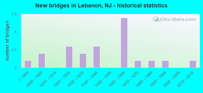
- New bridges - historical statistics
- 1Before 1900
- 21900-1909
- 31920-1929
- 21930-1939
- 31940-1949
- 71960-1969
- 11970-1979
- 11980-1989
- 11990-1999
- 12010-2019

- Reconstructed bridges - Historical Statistics
- 21980-1989
- 01990-1999
- 42000-2009
- 12010-2019


- Bridge Condition - Deck
- 5.6%Excellent
- 16.7%Very good
- 11.1%Good
- 44.4%Satisfactory
- 16.7%Fair
- 5.6%Serious

- Bridge Condition - Superstructure
- 5.6%Excellent
- 5.6%Very good
- 33.3%Good
- 38.9%Satisfactory
- 11.1%Fair
- 5.6%Poor

- Bridge Condition - Substructure
- 5.6%Very good
- 38.9%Good
- 38.9%Satisfactory
- 5.6%Fair
- 11.1%Poor

- Bridge Condition - Channel
- 33.3%Good
- 20.0%Satisfactory
- 46.7%Fair
Find on map >> Show street view
Structure Number: 100005, Location: 0.4MI SO OF MT AIRY VI RD (Lat: 40.396781, Lng: -74.900681), Route carried "on" structure: County highway 601, Year Built: 1938, Status: Open, Structure Length: 0.94m (3.08ft), Average Daily Traffic: 1,527 (year 2021), Truck Traffic: 3%, Average Future Daily Traffic: 1,862 (year 2041), Features Intersected: ALEXAUKEN CREEK TRIB
Minimum Vertical Clearance: 30+ m (98+ ft), Kilometerpoint: 4.764, Lanes on structure: 2, Owner: County Highway Agency, Approaching Roadway Width: 7.3m (24.0ft), Skew: 3 degrees, Material/Design: Steel, Design/Construction: Stringer/Multi-beam, Number Of Spans In Main Unit: 1, Length of Maximum Span: 7.6m (24.9ft), Curb-To-Curb Width: 7.5m (24.6ft), Out-to-Out Width: 8.3m (27.2ft)
Condition: Deck: Satisfactory, Superstructure: Satisfactory, Substructure: Fair, Channel: Fair, Operating Rating: 71.7 metric tons, Method Used To Determine Operating Rating: Load Factor (LF), Inventory Rating: 42.6 metric tons, Method Used To Determine Inventory Rating: Load Factor (LF), Structural Evaluation: Somewhat better than minimum adequacy, Deck Geometry: Meets minimum limits, Waterway Adequacy: Better than present minimum criteria, Approach Roadway Alignment: Equal to present minimum criteria, Designated Inspection Frequency: Every 24 months, Inspection Date: April 2021, Deck Structure Type: Concrete Cast-file-Place, Wearing Surface/Protective System: Wearing Surface: Bituminous
Find on map >> Show street view
Structure Number: 1000059, Location: 1425 FT.S. OF MAIN ST (Lat: 40.637500, Lng: -74.833439), Route carried "on" structure: County highway 629, Year Built: 1921, Year Reconstructed: 1987, Status: Open, Structure Length: 0.91m (2.99ft), Average Daily Traffic: 1,353 (year 2021), Truck Traffic: 3%, Average Future Daily Traffic: 1,624 (year 2041), Features Intersected: SO.BR.ROCKAWAY CREEK, Facility Carried by Structure: CHERRY STREET
Minimum Vertical Clearance: 30+ m (98+ ft), Kilometerpoint: 20.020, Lanes on structure: 2, Owner: County Highway Agency, Approaching Roadway Width: 7.6m (24.9ft), Skew: 1 degrees, Material/Design: Concrete, Design/Construction: Slab, Number Of Spans In Main Unit: 2, Length of Maximum Span: 3.7m (12.1ft), Curb-To-Curb Width: 7.8m (25.6ft), Out-to-Out Width: 8.8m (28.9ft)
Condition: Deck: Satisfactory, Superstructure: Satisfactory, Substructure: Satisfactory, Channel: Fair, Operating Rating: 54.4 metric tons, Method Used To Determine Operating Rating: Field evaluation and documented engineering judgment, Inventory Rating: 32.7 metric tons, Method Used To Determine Inventory Rating: Field evaluation and documented engineering judgment, Structural Evaluation: Equal to present minimum criteria, Deck Geometry: Meets minimum limits, Waterway Adequacy: Better than present minimum criteria, Approach Roadway Alignment: Better than present minimum criteria, Designated Inspection Frequency: Every 24 months, Inspection Date: March 2021, Deck Structure Type: Concrete Cast-file-Place, Wearing Surface/Protective System: Wearing Surface: Bituminous
Find on map >> Show street view
Structure Number: 100006, Location: 1350 FT. S. OF RT. 22 (Lat: 40.637981, Lng: -74.835550), Route carried "on" structure: City street , Year Built: 1925, Year Reconstructed: 2005, Status: Open, Structure Length: 0.85m (2.79ft), Average Daily Traffic: 241 (year 2021), Truck Traffic: 1%, Average Future Daily Traffic: 294 (year 2041), Features Intersected: SOUTH BR. ROCKAWAY CREEK, Facility Carried by Structure: CENTRAL STREET
Minimum Vertical Clearance: 30+ m (98+ ft), Kilometerpoint: 0.000, Lanes on structure: 2, Owner: County Highway Agency, Approaching Roadway Width: 4.9m (16.1ft), Material/Design: Steel, Design/Construction: Stringer/Multi-beam, Number Of Spans In Main Unit: 1, Length of Maximum Span: 7.9m (25.9ft), Curb or Sidewalk Widths: Left: 1.6m (5.2ft), Right: 0.0m, Curb-To-Curb Width: 5.7m (18.7ft), Out-to-Out Width: 7.6m (24.9ft)
Condition: Deck: Very good, Superstructure: Very good, Substructure: Satisfactory, Channel: Satisfactory, Operating Rating: 59.9 metric tons, Method Used To Determine Operating Rating: Load Factor (LF), Inventory Rating: 36.3 metric tons, Method Used To Determine Inventory Rating: Load Factor (LF), Structural Evaluation: Equal to present minimum criteria, Deck Geometry: High priority of corrective action, Waterway Adequacy: Better than present minimum criteria, Approach Roadway Alignment: Equal to present minimum criteria, Length Of Structure Improvement: 0.85m (2.79ft), Designated Inspection Frequency: Every 24 months, Inspection Date: May 2021, Bridge Improvement Cost: $78,000, Roadway Improvement Cost: $16,000, Total Project Cost: $174,000 ( Estimate for 2021), Deck Structure Type: Corrugated Steel, Wearing Surface/Protective System: Wearing Surface: Bituminous
Find on map >> Show street view
Structure Number: 10000Z4, Location: 2 MI E OF INT I-78 & US22 (Lat: 40.641861, Lng: -74.826969), Route carried "on" structure: Other road , Year Built: 1921, Status: Open, Structure Length: 0.82m (2.69ft), Average Daily Traffic: 2,149 (year 2021), Truck Traffic: 3%, Average Future Daily Traffic: 2,579 (year 2041), Features Intersected: TRIB. OF ROCKAWAY CREEK, Facility Carried by Structure: MAIN STREET
Minimum Vertical Clearance: 30+ m (98+ ft), Kilometerpoint: 1.642, Lanes on structure: 2, Owner: County Highway Agency, Approaching Roadway Width: 9.1m (29.9ft), Skew: 1 degrees, Material/Design: Steel, Design/Construction: Stringer/Multi-beam, Number Of Spans In Main Unit: 1, Length of Maximum Span: 7.3m (24.0ft), Curb-To-Curb Width: 9.1m (29.9ft), Out-to-Out Width: 9.9m (32.5ft)
Condition: Deck: Fair, Superstructure: Fair, Substructure: Satisfactory, Channel: Fair, Operating Rating: 49.9 metric tons, Method Used To Determine Operating Rating: Field evaluation and documented engineering judgment, Inventory Rating: 29.9 metric tons, Method Used To Determine Inventory Rating: Field evaluation and documented engineering judgment, Structural Evaluation: Somewhat better than minimum adequacy, Deck Geometry: Meets minimum limits, Waterway Adequacy: Better than present minimum criteria, Approach Roadway Alignment: Equal to present desirable criteria, Designated Inspection Frequency: Every 24 months, Inspection Date: March 2021, Deck Structure Type: Concrete Cast-file-Place, Wearing Surface/Protective System: Wearing Surface: Bituminous
Find on map >> Show street view
Structure Number: 1000L61, Location: 0.5 MI S. OF ANTHONY RD (Lat: 40.741169, Lng: -74.888111), Route carried "on" structure: Other road , Year Built: 1983, Status: Open, Structure Length: 0.88m (2.89ft), Average Daily Traffic: 2,278 (year 2021), Truck Traffic: 3%, Average Future Daily Traffic: 2,733 (year 2041), Design Load: HS 20+Mod, Features Intersected: SPRUCE RUN, Facility Carried by Structure: WOODGLEN ROAD
Minimum Vertical Clearance: 30+ m (98+ ft), Kilometerpoint: 0.000, Lanes on structure: 2, Owner: County Highway Agency, Approaching Roadway Width: 7.3m (24.0ft), Skew: 1 degrees, Material/Design: Wood or Timber, Design/Construction: Slab, Number Of Spans In Main Unit: 1, Length of Maximum Span: 8.2m (26.9ft), Curb-To-Curb Width: 7.3m (24.0ft), Out-to-Out Width: 7.6m (24.9ft)
Condition: Deck: Satisfactory, Superstructure: Satisfactory, Substructure: Good, Channel: Good, Operating Rating: 41.7 metric tons, Method Used To Determine Operating Rating: Allowable Stress (AS), Inventory Rating: 26.3 metric tons, Method Used To Determine Inventory Rating: Allowable Stress (AS), Structural Evaluation: Equal to present minimum criteria, Deck Geometry: High priority of replacement, Waterway Adequacy: Superior to present desirable criteria, Approach Roadway Alignment: Better than present minimum criteria, Length Of Structure Improvement: 0.88m (2.89ft), Designated Inspection Frequency: Every 24 months, Inspection Date: April 2021, Bridge Improvement Cost: $81,000, Roadway Improvement Cost: $50,000, Total Project Cost: $197,000 ( Estimate for 2021), Deck Structure Type: Wood or Timber, Wearing Surface/Protective System: Wearing Surface: Bituminous
Find on map >> Show street view
Structure Number: 1005151, Location: 0.5 MI E OF I-78 JCT (Lat: 40.642219, Lng: -74.864319), Route carried "on" structure: US 22, Year Built: 1937, Status: Open, Structure Length: 4.08m (13.39ft), Average Daily Traffic: 20,024 (year 2020), Truck Traffic: 4%, Average Future Daily Traffic: 24,029 (year 2040), Features Intersected: NJT RARITAN VALLEY LINE
Minimum Vertical Clearance: 30+ m (98+ ft), Kilometerpoint: 32.332, Lanes on structure: 3, Base Highway Network: Yes, Owner: State Highway Agency, Approaching Roadway Width: 23.2m (76.1ft), Skew: 25 degrees, Material/Design: Steel, Design/Construction: Stringer/Multi-beam, Number Of Spans In Main Unit: 3, Length of Maximum Span: 17.4m (57.1ft), Curb or Sidewalk Widths: Left: 1.3m (4.3ft), Right: 1.4m (4.6ft), Curb-To-Curb Width: 23.2m (76.1ft), Out-to-Out Width: 27.4m (89.9ft)
Condition: Deck: Serious, Superstructure: Fair, Substructure: Poor, Operating Rating: 41.7 metric tons, Method Used To Determine Operating Rating: Load Factor (LF), Inventory Rating: 24.5 metric tons, Method Used To Determine Inventory Rating: Load Factor (LF), Structural Evaluation: Meets minimum limits, Deck Geometry: Superior to present desirable criteria, Underclear: Meets minimum limits, Approach Roadway Alignment: Equal to present desirable criteria, Length Of Structure Improvement: 4.91m (16.11ft), Designated Inspection Frequency: Every 24 months, Inspection Date: April 2020, Bridge Improvement Cost: $4,981,000, Roadway Improvement Cost: $498,000, Total Project Cost: $7,735,000 ( Estimate for 2020), Deck Structure Type: Concrete Cast-file-Place, Wearing Surface/Protective System: Wearing Surface: Bituminous, Membrane: Preformed Fabric
Find on map >> Show street view
Structure Number: 1005153, Location: 4.0 MI W OF CO. 523 JCT (Lat: 40.643781, Lng: -74.835431), Route carried "on" structure: US 22, Year Built: 1942, Status: Open, Structure Length: 0.79m (2.59ft), Average Daily Traffic: 29,209 (year 2020), Truck Traffic: 4%, Average Future Daily Traffic: 35,640 (year 2040), Features Intersected: BR. ROCKAWAY CREEK
Minimum Vertical Clearance: 30+ m (98+ ft), Kilometerpoint: 34.778, Lanes on structure: 4, Owner: State Highway Agency, Approaching Roadway Width: 22.6m (74.1ft), Skew: 23 degrees, Material/Design: Concrete, Design/Construction: Frame, Number Of Spans In Main Unit: 1, Length of Maximum Span: 7.0m (23.0ft), Curb or Sidewalk Widths: Left: 2.3m (7.5ft), Right: 2.3m (7.5ft), Curb-To-Curb Width: 22.6m (74.1ft), Out-to-Out Width: 42.8m (140.4ft)
Condition: Deck: Satisfactory, Superstructure: Satisfactory, Substructure: Satisfactory, Channel: Fair, Inventory Rating: 82.6 metric tons, Method Used To Determine Inventory Rating: Load Factor (LF), Structural Evaluation: Equal to present minimum criteria, Deck Geometry: Superior to present desirable criteria, Waterway Adequacy: Equal to present minimum criteria, Approach Roadway Alignment: Equal to present desirable criteria, Length Of Structure Improvement: 0.82m (2.69ft), Designated Inspection Frequency: Every 24 months, Inspection Date: April 2020, Bridge Improvement Cost: $45,000, Total Project Cost: $45,000 ( Estimate for 2020), Deck Structure Type: Concrete Cast-file-Place, Wearing Surface/Protective System: Wearing Surface: Bituminous
Find on map >> Show street view
Structure Number: 1005156, Location: 1.23 MI EAST OF CR 639 (Lat: 40.644239, Lng: -74.812031), Route carried "on" structure: US 22, Year Built: 1942, Status: Open, Structure Length: 0.67m (2.20ft), Average Daily Traffic: 23,600 (year 2020), Truck Traffic: 4%, Average Future Daily Traffic: 28,300 (year 2040), Features Intersected: BRANCH OF ROCKAWAY CREEK
Minimum Vertical Clearance: 30+ m (98+ ft), Kilometerpoint: 36.822, Lanes on structure: 4, Base Highway Network: Yes, Owner: State Highway Agency, Approaching Roadway Width: 21.6m (70.9ft), Skew: 21 degrees, Material/Design: Concrete, Design/Construction: Slab, Number Of Spans In Main Unit: 1, Length of Maximum Span: 6.4m (21.0ft), Curb or Sidewalk Widths: Left: 2.1m (6.9ft), Right: 2.0m (6.6ft), Curb-To-Curb Width: 21.6m (70.9ft), Out-to-Out Width: 43.3m (142.1ft)
Condition: Deck: Satisfactory, Superstructure: Satisfactory, Substructure: Satisfactory, Channel: Fair, Operating Rating: 61.7 metric tons, Method Used To Determine Operating Rating: Load Factor (LF), Inventory Rating: 36.3 metric tons, Method Used To Determine Inventory Rating: Load Factor (LF), Structural Evaluation: Equal to present minimum criteria, Deck Geometry: Superior to present desirable criteria, Waterway Adequacy: Superior to present desirable criteria, Approach Roadway Alignment: Equal to present desirable criteria, Designated Inspection Frequency: Every 24 months, Inspection Date: May 2020, Deck Structure Type: Concrete Cast-file-Place, Wearing Surface/Protective System: Wearing Surface: Bituminous
Find on map >> Show street view
Structure Number: 1005162, Location: CO RT 523 JCT (Lat: 40.623200, Lng: -74.767000), Route carried "on" structure: US 22, Year Built: 1945, Year Reconstructed: 2012, Status: Open, Structure Length: 2.19m (7.19ft), Average Daily Traffic: 17,860 (year 2020), Truck Traffic: 4%, Average Future Daily Traffic: 21,792 (year 2040), Design Load: HL 93, Features Intersected: S BR ROCKAWAY RIVER
Minimum Vertical Clearance: 30+ m (98+ ft), Kilometerpoint: 41.312, Lanes on structure: 2, Base Highway Network: Yes, Owner: State Highway Agency, Approaching Roadway Width: 11.9m (39.0ft), Material/Design: Prestressed concrete, Design/Construction: Box Beam or Girders - Multiple, Number Of Spans In Main Unit: 1, Length of Maximum Span: 20.1m (65.9ft), Curb or Sidewalk Widths: Left: 0.0m, Right: 1.8m (5.9ft), Curb-To-Curb Width: 11.9m (39.0ft), Out-to-Out Width: 14.6m (47.9ft)
Condition: Deck: Good, Superstructure: Excellent, Substructure: Good, Channel: Fair, Operating Rating: 58.3 metric tons, Method Used To Determine Operating Rating: Load and Resistance Factor Rating (LRFR) rating reported by rating factor(RF) method using HL-93 loadings, Inventory Rating: 45.0 metric tons, Method Used To Determine Inventory Rating: Load and Resistance Factor Rating (LRFR) rating reported by rating factor(RF) method using HL-93 loadings, Structural Evaluation: Better than present minimum criteria, Deck Geometry: Better than present minimum criteria, Waterway Adequacy: Superior to present desirable criteria, Approach Roadway Alignment: Better than present minimum criteria, Length Of Structure Improvement: 2.19m (7.19ft), Designated Inspection Frequency: Every 24 months, Inspection Date: September 2020, Bridge Improvement Cost: $202,000, Total Project Cost: $202,000 ( Estimate for 2020), Deck Structure Type: Concrete Cast-file-Place, Wearing Surface/Protective System: Wearing Surface: Monolithic Concrete, Deck Protection: Epoxy Coated Reinforcing
Find on map >> Show street view
Structure Number: 1005164, Location: .23mi S of I78&639 inters (Lat: 40.643331, Lng: -74.835000), Route carried "on" structure: County highway 639, Year Built: 1967, Status: Open, Structure Length: 0.76m (2.49ft), Average Daily Traffic: 5,525 (year 2021), Truck Traffic: 3%, Average Future Daily Traffic: 7,801 (year 2041), Design Load: HS 20+Mod, Features Intersected: SOUTH BR.OF ROCKAWAY CR.
Minimum Vertical Clearance: 30+ m (98+ ft), Kilometerpoint: 0.000, Lanes on structure: 3, Owner: State Highway Agency, Approaching Roadway Width: 13.7m (44.9ft), Skew: 1 degrees, Material/Design: Concrete, Design/Construction: Slab, Number Of Spans In Main Unit: 1, Length of Maximum Span: 7.3m (24.0ft), Curb or Sidewalk Widths: Left: 1.8m (5.9ft), Right: 1.8m (5.9ft), Curb-To-Curb Width: 13.7m (44.9ft), Out-to-Out Width: 18.0m (59.1ft)
Condition: Deck: Satisfactory, Superstructure: Satisfactory, Substructure: Good, Channel: Satisfactory, Operating Rating: 48.1 metric tons, Method Used To Determine Operating Rating: Load Factor (LF), Inventory Rating: 28.1 metric tons, Method Used To Determine Inventory Rating: Load Factor (LF), Structural Evaluation: Equal to present minimum criteria, Deck Geometry: Somewhat better than minimum adequacy, Waterway Adequacy: Superior to present desirable criteria, Approach Roadway Alignment: Equal to present desirable criteria, Designated Inspection Frequency: Every 24 months, Inspection Date: July 2021, Deck Structure Type: Concrete Cast-file-Place, Wearing Surface/Protective System: Wearing Surface: Monolithic Concrete
Find on map >> Show street view
Structure Number: 100C026, Location: 0.43 MI EAST OF NJ 31 (Lat: 40.590250, Lng: -74.860811), Route carried "on" structure: City street , Year Built: 2015, Status: Open, Structure Length: 1.46m (4.79ft), Average Daily Traffic: 188 (year 2021), Truck Traffic: 3%, Average Future Daily Traffic: 229 (year 2041), Design Load: HL 93, Features Intersected: PRESCOTT BROOK, Facility Carried by Structure: CRATETOWN ROAD
Minimum Vertical Clearance: 30+ m (98+ ft), Kilometerpoint: 0.000, Lanes on structure: 2, Owner: County Highway Agency, Approaching Roadway Width: 6.1m (20.0ft), Skew: 2 degrees, Material/Design: Prestressed concrete, Design/Construction: Slab, Number Of Spans In Main Unit: 1, Length of Maximum Span: 13.1m (43.0ft), Curb-To-Curb Width: 7.9m (25.9ft), Out-to-Out Width: 8.9m (29.2ft)
Condition: Deck: Very good, Superstructure: Good, Substructure: Very good, Channel: Good, Operating Rating: 43.4 metric tons, Method Used To Determine Operating Rating: Load and Resistance Factor Rating (LRFR) rating reported by rating factor(RF) method using HL-93 loadings, Inventory Rating: 33.7 metric tons, Method Used To Determine Inventory Rating: Load and Resistance Factor Rating (LRFR) rating reported by rating factor(RF) method using HL-93 loadings, Structural Evaluation: Better than present minimum criteria, Deck Geometry: Somewhat better than minimum adequacy, Waterway Adequacy: Better than present minimum criteria, Approach Roadway Alignment: Equal to present desirable criteria, Designated Inspection Frequency: Every 24 months, Inspection Date: July 2021, Deck Structure Type: Concrete Precast Panels, Wearing Surface/Protective System: Wearing Surface: Bituminous, Membrane: Preformed Fabric, Deck Protection: Epoxy Coated Reinforcing
Find on map >> Show street view
Structure Number: 100C032, Location: 0.7 MILE EAST OF NJ 31 (Lat: 40.595431, Lng: -74.858800), Route carried "on" structure: City street , Year Built: 1899, Status: Posted for load, Structure Length: 1.43m (4.69ft), Average Daily Traffic: 1,270 (year 2021), Truck Traffic: 3%, Average Future Daily Traffic: 1,550 (year 2041), Features Intersected: PRESCOTT BROOK, Facility Carried by Structure: PAYNE ROAD
Minimum Vertical Clearance: 30+ m (98+ ft), Kilometerpoint: 0.000, Lanes on structure: 1, Owner: County Highway Agency, Approaching Roadway Width: 5.8m (19.0ft), Skew: 1 degrees, Material/Design: Steel, Design/Construction: Truss - Thru, Number Of Spans In Main Unit: 1, Length of Maximum Span: 14.3m (46.9ft), Curb-To-Curb Width: 4.8m (15.7ft), Out-to-Out Width: 4.8m (15.7ft)
Condition: Deck: Satisfactory, Superstructure: Poor, Substructure: Poor, Channel: Good, Operating Rating: 10.9 metric tons, Method Used To Determine Operating Rating: Load Factor (LF), Inventory Rating: 6.4 metric tons, Method Used To Determine Inventory Rating: Load Factor (LF), Structural Evaluation: High priority of replacement, Deck Geometry: High priority of corrective action, Waterway Adequacy: Better than present minimum criteria, Approach Roadway Alignment: Equal to present minimum criteria, Bridge Posting: Required (Relationship of Operating Rating to Maximum Legal Load: > 39.9% below), Length Of Structure Improvement: 1.43m (4.69ft), Designated Inspection Frequency: Every 24 months, Critical Feature Inspection Frequency: Every 24 months, Other Special Inspection Frequency: Every 12 months, Inspection Date: May 2021, Critical Feature Inspection Date: May 2021, Other Special Inspection Date: May 2021, Bridge Improvement Cost: $452,000, Roadway Improvement Cost: $50,000, Total Project Cost: $717,000 ( Estimate for 2021), Deck Structure Type: Corrugated Steel, Wearing Surface/Protective System: Wearing Surface: Bituminous
Find on map >> Show street view
Structure Number: 100T073, Location: 75' SOUTH OF ROCKAWAY RD (Lat: 40.676969, Lng: -74.793231), Route carried "on" structure: City street , Year Built: 1900, Year Reconstructed: 2019, Status: Posted for load, Structure Length: 1.86m (6.10ft), Average Daily Traffic: 134 (year 2021), Average Future Daily Traffic: 164 (year 2041), Features Intersected: NO BRANCH ROCKAWAY CREEK, Facility Carried by Structure: MEADOW LANE
Minimum Vertical Clearance: 30+ m (98+ ft), Kilometerpoint: 0.000, Lanes on structure: 1, Owner: County Highway Agency, Approaching Roadway Width: 4.9m (16.1ft), Material/Design: Aluminum, Iron, Design/Construction: Truss - Thru, Number Of Spans In Main Unit: 1, Length of Maximum Span: 18.3m (60.0ft), Curb-To-Curb Width: 4.2m (13.8ft), Out-to-Out Width: 4.3m (14.1ft)
Condition: Deck: Excellent, Superstructure: Satisfactory, Substructure: Good, Channel: Satisfactory, Operating Rating: 49.0 metric tons, Method Used To Determine Operating Rating: Load Factor (LF), Inventory Rating: 29.0 metric tons, Method Used To Determine Inventory Rating: Load Factor (LF), Structural Evaluation: Equal to present minimum criteria, Deck Geometry: High priority of replacement, Waterway Adequacy: Better than present minimum criteria, Approach Roadway Alignment: Equal to present minimum criteria, Length Of Structure Improvement: 1.86m (6.10ft), Designated Inspection Frequency: Every 24 months, Critical Feature Inspection Frequency: Every 24 months, Inspection Date: July 2021, Critical Feature Inspection Date: July 2021, Bridge Improvement Cost: $586,000, Roadway Improvement Cost: $50,000, Total Project Cost: $901,000 ( Estimate for 2021), Deck Structure Type: Corrugated Steel, Wearing Surface/Protective System: Wearing Surface: Bituminous, Deck Protection: Other
Find on map >> Show street view
Structure Number: 101815, Location: .8 MI EAST OF RT 31 (Lat: 40.640469, Lng: -74.877081), Route carried "on" structure: Ramp Interstate 78, Year Built: 1968, Year Reconstructed: 2011, Status: Open, Structure Length: 5.49m (18.01ft), Average Daily Traffic: 2,152 (year 2020), Truck Traffic: 4%, Average Future Daily Traffic: 2,583 (year 2040), Design Load: HS 20+Mod, Features Intersected: ROUTE 78
Minimum Vertical Clearance: 30+ m (98+ ft), Kilometerpoint: 29.708, Lanes on structure: 1, Lanes under structure: 7, Owner: State Highway Agency, Approaching Roadway Width: 6.7m (22.0ft), Skew: 1 degrees, Material/Design: Steel, Design/Construction: Stringer/Multi-beam, Number Of Spans In Main Unit: 2, Length of Maximum Span: 26.2m (86.0ft), Curb or Sidewalk Widths: Left: 0.0m, Right: 1.8m (5.9ft), Curb-To-Curb Width: 6.7m (22.0ft), Out-to-Out Width: 9.4m (30.8ft)
Condition: Deck: Good, Superstructure: Good, Substructure: Satisfactory, Inventory Rating: 83.5 metric tons, Method Used To Determine Inventory Rating: Load Factor (LF), Structural Evaluation: Equal to present minimum criteria, Deck Geometry: Equal to present minimum criteria, Underclear: Equal to present minimum criteria, Approach Roadway Alignment: Equal to present minimum criteria, Designated Inspection Frequency: Every 24 months, Inspection Date: June 2020, Deck Structure Type: Concrete Cast-file-Place, Wearing Surface/Protective System: Wearing Surface: Monolithic Concrete, Deck Protection: Epoxy Coated Reinforcing
Find on map >> Show street view
Structure Number: 1018158, Location: 0.34 MI W of I-78 Exit 20 (Lat: 40.647069, Lng: -74.840681), Route carried "on" structure: Interstate 78, Year Built: 1966, Status: Open, Structure Length: 0.64m (2.10ft), Average Daily Traffic: 126,908 (year 2021), Truck Traffic: 9%, Average Future Daily Traffic: 152,290 (year 2041), Design Load: HS 20, Features Intersected: BRANCH ROCKAWAY CREEK
Minimum Vertical Clearance: 30+ m (98+ ft), Kilometerpoint: 32.895, Lanes on structure: 6, Base Highway Network: Yes, Owner: State Highway Agency, Approaching Roadway Width: 31.1m (102.0ft), Skew: 30 degrees, Material/Design: Concrete, Design/Construction: Culvert, Number Of Spans In Main Unit: 2, Length of Maximum Span: 3.0m (9.8ft)
Condition: Channel: Fair, Culverts: Satisfactory, Structural Evaluation: Equal to present minimum criteria, Waterway Adequacy: Superior to present desirable criteria, Approach Roadway Alignment: Equal to present desirable criteria, Designated Inspection Frequency: Every 24 months, Inspection Date: April 2021
Find on map >> Show street view
Structure Number: 1018159, Location: 3 MI EAST OF RT 31 (Lat: 40.646969, Lng: -74.834319), Route carried "on" structure: County highway 639, Year Built: 1968, Year Reconstructed: 2013, Status: Open, Structure Length: 7.04m (23.10ft), Average Daily Traffic: 7,922 (year 2021), Truck Traffic: 3%, Average Future Daily Traffic: 9,507 (year 2041), Design Load: HL 93, Features Intersected: I-78, Facility Carried by Structure: COKESBURY ROAD
Minimum Vertical Clearance: 30+ m (98+ ft), Kilometerpoint: 0.386, Lanes on structure: 3, Lanes under structure: 7, Owner: State Highway Agency, Approaching Roadway Width: 12.5m (41.0ft), Skew: 1 degrees, Material/Design: Steel, Design/Construction: Stringer/Multi-beam, Number Of Spans In Main Unit: 4, Length of Maximum Span: 27.1m (88.9ft), Curb or Sidewalk Widths: Left: 1.8m (5.9ft), Right: 1.8m (5.9ft), Curb-To-Curb Width: 12.5m (41.0ft), Out-to-Out Width: 16.8m (55.1ft)
Condition: Deck: Very good, Superstructure: Good, Substructure: Good, Operating Rating: 74.5 metric tons, Method Used To Determine Operating Rating: Load and Resistance Factor Rating (LRFR) rating reported by rating factor(RF) method using HL-93 loadings, Inventory Rating: 57.3 metric tons, Method Used To Determine Inventory Rating: Load and Resistance Factor Rating (LRFR) rating reported by rating factor(RF) method using HL-93 loadings, Structural Evaluation: Better than present minimum criteria, Deck Geometry: Meets minimum limits, Underclear: Somewhat better than minimum adequacy, Approach Roadway Alignment: Equal to present desirable criteria, Designated Inspection Frequency: Every 24 months, Inspection Date: April 2021, Deck Structure Type: Concrete Cast-file-Place, Wearing Surface/Protective System: Wearing Surface: Monolithic Concrete, Deck Protection: Epoxy Coated Reinforcing
Find on map >> Show street view
Structure Number: 1018161, Location: 0.7 MI E OF I-78 EXIT 20 (Lat: 40.646350, Lng: -74.820131), Route carried "on" structure: City street , Year Built: 1965, Status: Open, Structure Length: 5.39m (17.68ft), Average Daily Traffic: 1,641 (year 2021), Truck Traffic: 1%, Average Future Daily Traffic: 1,969 (year 2041), Design Load: HS 20+Mod, Features Intersected: I-78, Facility Carried by Structure: BLOSSOM HILL RD
Minimum Vertical Clearance: 30+ m (98+ ft), Kilometerpoint: 0.000, Lanes on structure: 2, Lanes under structure: 6, Owner: State Highway Agency, Approaching Roadway Width: 9.1m (29.9ft), Skew: 1 degrees, Material/Design: Prestressed concrete, Design/Construction: Stringer/Multi-beam, Number Of Spans In Main Unit: 2, Length of Maximum Span: 26.2m (86.0ft), Curb or Sidewalk Widths: Left: 1.8m (5.9ft), Right: 1.8m (5.9ft), Curb-To-Curb Width: 9.1m (29.9ft), Out-to-Out Width: 13.4m (44.0ft)
Condition: Deck: Fair, Superstructure: Good, Substructure: Good, Operating Rating: 81.6 metric tons, Method Used To Determine Operating Rating: Load Factor (LF), Inventory Rating: 41.7 metric tons, Method Used To Determine Inventory Rating: Load Factor (LF), Structural Evaluation: Better than present minimum criteria, Deck Geometry: Somewhat better than minimum adequacy, Underclear: Somewhat better than minimum adequacy, Approach Roadway Alignment: Equal to present desirable criteria, Designated Inspection Frequency: Every 24 months, Inspection Date: April 2021, Deck Structure Type: Concrete Cast-file-Place, Wearing Surface/Protective System: Wearing Surface: Monolithic Concrete
Find on map >> Show street view
Structure Number: 10C0104, Location: 0.3 MI WEST OF CR 639 (Lat: 40.659969, Lng: -74.833061), Route carried "on" structure: City street , Year Built: 1992, Status: Open, Structure Length: 0.79m (2.59ft), Average Daily Traffic: 541 (year 2021), Truck Traffic: 3%, Average Future Daily Traffic: 660 (year 2041), Features Intersected: Beaver Brook, Facility Carried by Structure: Chalfont Drive
Minimum Vertical Clearance: 30+ m (98+ ft), Kilometerpoint: 0.000, Lanes on structure: 2, Owner: County Highway Agency, Approaching Roadway Width: 9.1m (29.9ft), Material/Design: Concrete, Design/Construction: Culvert, Number Of Spans In Main Unit: 2, Length of Maximum Span: 3.7m (12.1ft)
Condition: Channel: Good, Culverts: Satisfactory, Operating Rating: 54.4 metric tons, Method Used To Determine Operating Rating: Field evaluation and documented engineering judgment, Inventory Rating: 32.7 metric tons, Method Used To Determine Inventory Rating: Field evaluation and documented engineering judgment, Structural Evaluation: Equal to present minimum criteria, Waterway Adequacy: Equal to present desirable criteria, Approach Roadway Alignment: Better than present minimum criteria, Designated Inspection Frequency: Every 24 months, Inspection Date: June 2021
Find on map >> Show street view
Structure Number: 10XXT82, Location: 1 MI SOUTH OF MAIN STREET (Lat: 40.679500, Lng: -74.799811), Route carried "on" structure: City street , Year Built: 1900, Year Reconstructed: 1986, Status: Open, Structure Length: 1.68m (5.51ft), Average Daily Traffic: 385 (year 2021), Truck Traffic: 5%, Average Future Daily Traffic: 470 (year 2041), Design Load: HS 20+Mod, Features Intersected: ROCKAWAY CREEK, Facility Carried by Structure: ROCKAWAY ROAD
Minimum Vertical Clearance: 30+ m (98+ ft), Kilometerpoint: 5.327, Lanes on structure: 2, Owner: County Highway Agency, Approaching Roadway Width: 7.9m (25.9ft), Material/Design: Wood or Timber, Design/Construction: Stringer/Multi-beam, Number Of Spans In Main Unit: 1, Length of Maximum Span: 15.5m (50.9ft), Curb-To-Curb Width: 8.1m (26.6ft), Out-to-Out Width: 8.4m (27.6ft)
Condition: Deck: Satisfactory, Superstructure: Good, Substructure: Satisfactory, Channel: Good, Operating Rating: 32.7 metric tons, Method Used To Determine Operating Rating: Allowable Stress (AS), Inventory Rating: 19.1 metric tons, Method Used To Determine Inventory Rating: Allowable Stress (AS), Structural Evaluation: Somewhat better than minimum adequacy, Deck Geometry: Somewhat better than minimum adequacy, Waterway Adequacy: Equal to present desirable criteria, Approach Roadway Alignment: Better than present minimum criteria, Designated Inspection Frequency: Every 24 months, Inspection Date: April 2021, Deck Structure Type: Wood or Timber, Wearing Surface/Protective System: Wearing Surface: Bituminous
Find on map >> Show street view
Structure Number: 3487001, Location: 0.24 Mi South of RT22 Jct (Lat: 40.639581, Lng: -74.850500), Route carried "on" structure: County highway 621, Year Built: 1977, Status: Open, Structure Length: 3.02m (9.91ft), Average Daily Traffic: 2,224 (year 2021), Truck Traffic: 4%, Average Future Daily Traffic: 2,714 (year 2041), Design Load: HS 20, Features Intersected: NJT(RARITAN VALLEY LINE), Facility Carried by Structure: ROUND VALLEY ROAD
Minimum Vertical Clearance: 30+ m (98+ ft), Kilometerpoint: 0.789, Lanes on structure: 2, Owner: State Agenciy, Approaching Roadway Width: 13.4m (44.0ft), Skew: 2 degrees, Material/Design: Steel, Design/Construction: Stringer/Multi-beam, Number Of Spans In Main Unit: 1, Length of Maximum Span: 28.3m (92.8ft), Curb-To-Curb Width: 13.4m (44.0ft), Out-to-Out Width: 14.3m (46.9ft)
Condition: Deck: Fair, Superstructure: Good, Substructure: Good, Operating Rating: 84.4 metric tons, Method Used To Determine Operating Rating: Load Factor (LF), Inventory Rating: 50.8 metric tons, Method Used To Determine Inventory Rating: Load Factor (LF), Structural Evaluation: Better than present minimum criteria, Deck Geometry: Better than present minimum criteria, Underclear: Equal to present minimum criteria, Approach Roadway Alignment: Better than present minimum criteria, Designated Inspection Frequency: Every 24 months, Inspection Date: September 2021, Deck Structure Type: Concrete Cast-file-Place, Wearing Surface/Protective System: Wearing Surface: Monolithic Concrete
Find on map >> Show street view
Structure Number: 1018159, Location: 3 MI EAST OF RT 31 (Lat: 40.646969, Lng: -74.834319), Route carried "under" structure: Interstate 78, Year Built: 1968, Structure Length: 0. m, Average Daily Traffic: 115,443 (year 2021), Truck Traffic: 9%, Features Intersected: I-78, Facility Carried by Structure: COKESBURY ROAD
Minimum Vertical Clearance: 5.31m (17.42ft), Kilometerpoint: 33.442, Lanes on structure: 3, Lanes under structure: 7, Material/Design: Steel, Design/Construction: Stringer/Multi-beam, Length of Maximum Span: 27.1m (88.9ft)
Find on map >> Show street view
Structure Number: 1018161, Location: 0.7 MI E OF I-78 EXIT 20 (Lat: 40.646350, Lng: -74.820131), Route carried "under" structure: Interstate 78, Year Built: 1965, Structure Length: 0. m, Average Daily Traffic: 119,691 (year 2021), Truck Traffic: 9%, Features Intersected: I-78, Facility Carried by Structure: BLOSSOM HILL RD
Minimum Vertical Clearance: 5.13m (16.83ft), Kilometerpoint: 34.633, Lanes on structure: 2, Lanes under structure: 6, Material/Design: Prestressed concrete, Design/Construction: Stringer/Multi-beam, Length of Maximum Span: 26.2m (86.0ft)