Bridge Statistics for Lecompte, Louisiana (LA)
Condition, Traffic, Stress, Structural Evaluation, Project Costs
- National Bridge Inventory (NBI) Statistics
- 19Number of bridges
- 207ft / 63.1mTotal length
- $2,362,000Total costs
- 50,075Total average daily traffic
- 2,839Total average daily truck traffic
- National Bridge Inventory (NBI) Registered Bridges for Lecompte
- No street view available for this location
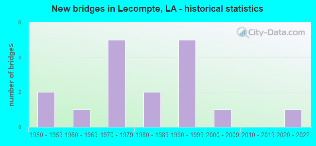
- New bridges - historical statistics
- 21950-1959
- 11960-1969
- 51970-1979
- 21980-1989
- 51990-1999
- 12000-2009
- 12020-2022


- Bridge Condition - Deck
- 68.8%Good
- 18.8%Satisfactory
- 6.3%Fair
- 6.3%Poor

- Bridge Condition - Superstructure
- 62.5%Good
- 18.8%Satisfactory
- 12.5%Poor
- 6.3%Serious

- Bridge Condition - Substructure
- 56.3%Good
- 6.3%Satisfactory
- 6.3%Fair
- 18.8%Poor
- 6.3%Serious
- 6.3%Imminent failure

- Bridge Condition - Channel
- 6.3%Excellent
- 50.0%Good
- 12.5%Satisfactory
- 12.5%Fair
- 18.8%Poor
Find on map >> Show street view
Structure Number: 84000000080014, Location: 2.37 MI NW OF LA 112 (Lat: 31.088711, Lng: -92.462050), Route carried "on" structure: County highway , Year Built: 2021, Status: Open, Structure Length: 2.44m (8.01ft), Average Daily Traffic: 825 (year 2019), Truck Traffic: 1%, Average Future Daily Traffic: 910 (year 2039), Design Load: Greater than HL93, Features Intersected: INDIAN CREEK RESERVOIR, Facility Carried by Structure: H. STRANGE RD
Minimum Vertical Clearance: 30+ m (98+ ft), Kilometerpoint: 0.000, Lanes on structure: 2, Owner: County Highway Agency, Approaching Roadway Width: 6.1m (20.0ft), Material/Design: Concrete, Design/Construction: Slab, Number Of Spans In Main Unit: 4, Length of Maximum Span: 6.1m (20.0ft), Curb-To-Curb Width: 7.2m (23.6ft), Out-to-Out Width: 8.1m (26.6ft)
Condition: Deck: Good, Superstructure: Good, Substructure: Good, Channel: Excellent, Operating Rating: 57.0 metric tons, Method Used To Determine Operating Rating: Load and Resistance Factor Rating (LRFR) rating reported by rating factor(RF) method using HL-93 loadings, Inventory Rating: 44.1 metric tons, Method Used To Determine Inventory Rating: Load and Resistance Factor Rating (LRFR) rating reported by rating factor(RF) method using HL-93 loadings, Structural Evaluation: Better than present minimum criteria, Deck Geometry: Meets minimum limits, Waterway Adequacy: Superior to present desirable criteria, Approach Roadway Alignment: Equal to present desirable criteria, Designated Inspection Frequency: Every 24 months, Inspection Date: October 2021, Deck Structure Type: Concrete Cast-file-Place
Find on map >> Show street view
Structure Number: 84000000600368, Location: 3.42 MILES SE OF LA 3265 (Lat: 31.122889, Lng: -92.439400), Route carried "on" structure: County highway , Year Built: 2009, Status: Open, Structure Length: 6.10m (20.01ft), Average Daily Traffic: 250 (year 1976), Average Future Daily Traffic: 325 (year 2036), Design Load: HS 20, Features Intersected: BAYOU BOEUF, Facility Carried by Structure: Forestry Rd
Minimum Vertical Clearance: 30+ m (98+ ft), Kilometerpoint: 7.311, Lanes on structure: 2, Owner: County Highway Agency, Approaching Roadway Width: 8.5m (27.9ft), Skew: 30 degrees, Material/Design: Prestressed concrete, Design/Construction: Stringer/Multi-beam, Number Of Spans In Main Unit: 5, Length of Maximum Span: 12.2m (40.0ft), Curb-To-Curb Width: 8.3m (27.2ft), Out-to-Out Width: 9.2m (30.2ft)
Condition: Deck: Good, Superstructure: Good, Substructure: Good, Channel: Good, Operating Rating: 45.4 metric tons, Method Used To Determine Operating Rating: Load and Resistance Factor Rating (LRFR) rating reported by rating factor(RF) method using HL-93 loadings, Inventory Rating: 34.3 metric tons, Method Used To Determine Inventory Rating: Load and Resistance Factor Rating (LRFR) rating reported by rating factor(RF) method using HL-93 loadings, Structural Evaluation: Better than present minimum criteria, Deck Geometry: Somewhat better than minimum adequacy, Waterway Adequacy: Equal to present minimum criteria, Approach Roadway Alignment: Meets minimum limits, Designated Inspection Frequency: Every 24 months, Underwater Inspection Frequency: Every 60 months, Inspection Date: October 2021, Underwater Inspection Date: May 2018, Deck Structure Type: Concrete Cast-file-Place, Wearing Surface/Protective System: Wearing Surface: Monolithic Concrete
Find on map >> Show street view
Structure Number: 84000080904191, Location: 1.49 MI. NORTH OF LA 112 (Lat: 31.108500, Lng: -92.402900), Route carried "on" structure: US 71, Year Built: 1977, Status: Open, Structure Length: 0.76m (2.49ft), Average Daily Traffic: 4,800 (year 2016), Truck Traffic: 15%, Average Future Daily Traffic: 6,240 (year 2036), Design Load: HS 20, Features Intersected: HORSEFARM DITCH
Minimum Vertical Clearance: 30+ m (98+ ft), Kilometerpoint: 6.698, Lanes on structure: 4, Base Highway Network: Yes (Inventory Route: 8-09-1, Subroute: 10), Owner: State Highway Agency, Approaching Roadway Width: 23.2m (76.1ft), Skew: 30 degrees, Material/Design: Concrete, Design/Construction: Culvert, Number Of Spans In Main Unit: 3, Length of Maximum Span: 2.4m (7.9ft)
Condition: Channel: Good, Culverts: Very good, Operating Rating: 42.1 metric tons, Method Used To Determine Operating Rating: Load and Resistance Factor Rating (LRFR) rating reported by rating factor(RF) method using HL-93 loadings, Inventory Rating: 32.4 metric tons, Method Used To Determine Inventory Rating: Load and Resistance Factor Rating (LRFR) rating reported by rating factor(RF) method using HL-93 loadings, Structural Evaluation: Equal to present desirable criteria, Waterway Adequacy: Better than present minimum criteria, Approach Roadway Alignment: Equal to present desirable criteria, Designated Inspection Frequency: Every 24 months, Inspection Date: March 2020, Deck Structure Type: Concrete Cast-file-Place
Find on map >> Show street view
Structure Number: 84000080905661, Location: 2.96 MI. NORTH OF LA 112 (Lat: 31.129511, Lng: -92.407400), Route carried "on" structure: US 71, Year Built: 1977, Status: Open, Structure Length: 3.05m (10.01ft), Average Daily Traffic: 2,400 (year 2016), Truck Traffic: 15%, Average Future Daily Traffic: 3,744 (year 2036), Design Load: HS 20, Features Intersected: BAYOU LAMOURIE
Minimum Vertical Clearance: 30+ m (98+ ft), Kilometerpoint: 9.065, Lanes on structure: 2, Base Highway Network: Yes (Inventory Route: 8-09-1, Subroute: 10), Owner: State Highway Agency, Approaching Roadway Width: 12.2m (40.0ft), Skew: 36 degrees, Material/Design: Concrete, Design/Construction: Slab, Number Of Spans In Main Unit: 5, Length of Maximum Span: 6.1m (20.0ft), Curb-To-Curb Width: 12.2m (40.0ft), Out-to-Out Width: 13.1m (43.0ft)
Condition: Deck: Good, Superstructure: Good, Substructure: Good, Channel: Good, Operating Rating: 71.7 metric tons, Method Used To Determine Operating Rating: Load Factor (LF), Inventory Rating: 42.6 metric tons, Method Used To Determine Inventory Rating: Load Factor (LF), Structural Evaluation: Better than present minimum criteria, Deck Geometry: Better than present minimum criteria, Waterway Adequacy: Better than present minimum criteria, Approach Roadway Alignment: Equal to present desirable criteria, Designated Inspection Frequency: Every 24 months, Inspection Date: March 2020, Deck Structure Type: Concrete Cast-file-Place, Wearing Surface/Protective System: Wearing Surface: Monolithic Concrete
Find on map >> Show street view
Structure Number: 84000080905662, Location: 2.96 MI. NORTH OF LA 112 (Lat: 31.129939, Lng: -92.407800), Route carried "on" structure: US 71, Year Built: 1977, Status: Open, Structure Length: 3.05m (10.01ft), Average Daily Traffic: 2,400 (year 2016), Truck Traffic: 15%, Average Future Daily Traffic: 3,744 (year 2036), Design Load: HS 20, Features Intersected: BAYOU LAMOURIE
Minimum Vertical Clearance: 30+ m (98+ ft), Kilometerpoint: 18.567, Lanes on structure: 2, Base Highway Network: Yes (Inventory Route: 8-09-2, Subroute: 10), Owner: State Highway Agency, Approaching Roadway Width: 12.2m (40.0ft), Skew: 36 degrees, Material/Design: Concrete, Design/Construction: Slab, Number Of Spans In Main Unit: 5, Length of Maximum Span: 6.1m (20.0ft), Curb-To-Curb Width: 12.2m (40.0ft), Out-to-Out Width: 13.1m (43.0ft)
Condition: Deck: Good, Superstructure: Good, Substructure: Good, Channel: Good, Operating Rating: 71.7 metric tons, Method Used To Determine Operating Rating: Load Factor (LF), Inventory Rating: 42.6 metric tons, Method Used To Determine Inventory Rating: Load Factor (LF), Structural Evaluation: Better than present minimum criteria, Deck Geometry: Better than present minimum criteria, Waterway Adequacy: Better than present minimum criteria, Approach Roadway Alignment: Equal to present desirable criteria, Designated Inspection Frequency: Every 24 months, Inspection Date: March 2020, Deck Structure Type: Concrete Cast-file-Place, Wearing Surface/Protective System: Wearing Surface: Monolithic Concrete
Find on map >> Show street view
Structure Number: 84000570802851, Location: 0.9 MI. SOUTH OF US 71 (Lat: 31.040181, Lng: -92.372200), Route carried "on" structure: US 167, Year Built: 1985, Status: Open, Structure Length: 4.11m (13.48ft), Average Daily Traffic: 1,030 (year 2016), Truck Traffic: 15%, Average Future Daily Traffic: 1,339 (year 2036), Design Load: HS 20, Features Intersected: BAYOU BOEUF
Minimum Vertical Clearance: 30+ m (98+ ft), Kilometerpoint: 4.551, Lanes on structure: 2, Base Highway Network: Yes (Inventory Route: 57-08-1, Subroute: 10), Owner: State Highway Agency, Approaching Roadway Width: 13.4m (44.0ft), Skew: 30 degrees, Material/Design: Concrete, Design/Construction: Slab, Number Of Spans In Main Unit: 7, Length of Maximum Span: 5.8m (19.0ft), Curb-To-Curb Width: 8.5m (27.9ft), Out-to-Out Width: 9.4m (30.8ft)
Condition: Deck: Satisfactory, Superstructure: Satisfactory, Substructure: Poor, Channel: Fair, Operating Rating: 30.8 metric tons, Method Used To Determine Operating Rating: Load and Resistance Factor Rating (LRFR) rating reported by rating factor(RF) method using HL-93 loadings, Inventory Rating: 24.0 metric tons, Method Used To Determine Inventory Rating: Load and Resistance Factor Rating (LRFR) rating reported by rating factor(RF) method using HL-93 loadings, Structural Evaluation: Meets minimum limits, Deck Geometry: Somewhat better than minimum adequacy, Waterway Adequacy: Equal to present minimum criteria, Approach Roadway Alignment: Equal to present desirable criteria, Length Of Structure Improvement: 5.03m (16.50ft), Designated Inspection Frequency: Every 24 months, Underwater Inspection Frequency: Every 60 months, Other Special Inspection Frequency: Every 12 months, Inspection Date: December 2020, Underwater Inspection Date: May 2018, Other Special Inspection Date: December 2021, Bridge Improvement Cost: $429,000, Total Project Cost: $643,000 ( Estimate for 2016), Deck Structure Type: Concrete Precast Panels, Wearing Surface/Protective System: Wearing Surface: Bituminous
Find on map >> Show street view
Structure Number: 84000730305411, Location: 5.41 MI. EAST OF US 165 (Lat: 31.061400, Lng: -92.452300), Route carried "on" structure: State highway 112, Year Built: 1971, Status: Open, Structure Length: 1.83m (6.00ft), Average Daily Traffic: 1,940 (year 2016), Truck Traffic: 14%, Average Future Daily Traffic: 2,522 (year 2036), Design Load: HS 20, Features Intersected: BEAVER CREEK TRIBUTARY
Minimum Vertical Clearance: 30+ m (98+ ft), Kilometerpoint: 8.624, Lanes on structure: 2, Owner: State Highway Agency, Approaching Roadway Width: 9.8m (32.2ft), Skew: 30 degrees, Material/Design: Concrete, Design/Construction: Slab, Number Of Spans In Main Unit: 3, Length of Maximum Span: 6.1m (20.0ft), Curb-To-Curb Width: 13.1m (43.0ft), Out-to-Out Width: 14.0m (45.9ft)
Condition: Deck: Good, Superstructure: Good, Substructure: Good, Channel: Poor, Operating Rating: 71.7 metric tons, Method Used To Determine Operating Rating: Load Factor (LF), Inventory Rating: 43.5 metric tons, Method Used To Determine Inventory Rating: Load Factor (LF), Structural Evaluation: Better than present minimum criteria, Deck Geometry: Better than present minimum criteria, Waterway Adequacy: Better than present minimum criteria, Approach Roadway Alignment: Better than present minimum criteria, Designated Inspection Frequency: Every 24 months, Inspection Date: June 2020, Deck Structure Type: Concrete Cast-file-Place, Wearing Surface/Protective System: Wearing Surface: Monolithic Concrete
Find on map >> Show street view
Structure Number: 84000730306651, Location: I-49/LA 112 INTG. (Lat: 31.071250, Lng: -92.433900), Route carried "on" structure: State highway 112, Year Built: 1989, Status: Open, Structure Length: 8.72m (28.61ft), Average Daily Traffic: 1,940 (year 2016), Truck Traffic: 14%, Average Future Daily Traffic: 2,522 (year 2036), Design Load: HS 20, Features Intersected: I-49
Minimum Vertical Clearance: 30+ m (98+ ft), Kilometerpoint: 10.725, Lanes on structure: 2, Lanes under structure: 4, Owner: State Highway Agency, Approaching Roadway Width: 9.1m (29.9ft), Skew: 32 degrees, Material/Design: Steel continuous, Design/Construction: Stringer/Multi-beam, Number Of Spans In Main Unit: 2, Length of Maximum Span: 43.6m (143.0ft), Curb-To-Curb Width: 20.1m (65.9ft), Out-to-Out Width: 21.0m (68.9ft)
Condition: Deck: Good, Superstructure: Good, Substructure: Good, Operating Rating: 79.8 metric tons, Method Used To Determine Operating Rating: Load Factor (LF), Inventory Rating: 48.1 metric tons, Method Used To Determine Inventory Rating: Load Factor (LF), Structural Evaluation: Better than present minimum criteria, Deck Geometry: Superior to present desirable criteria, Underclear: Equal to present minimum criteria, Approach Roadway Alignment: Equal to present minimum criteria, Designated Inspection Frequency: Every 24 months, Inspection Date: June 2020, Deck Structure Type: Concrete Cast-file-Place, Wearing Surface/Protective System: Wearing Surface: Monolithic Concrete
Find on map >> Show street view
Structure Number: 84000730308181, Location: 8.18 MI. E OF INT US165 (Lat: 31.079739, Lng: -92.413000), Route carried "on" structure: State highway 112, Year Built: 1952, Status: Open, Structure Length: 7.83m (25.69ft), Average Daily Traffic: 1,940 (year 2016), Truck Traffic: 14%, Average Future Daily Traffic: 2,522 (year 2036), Design Load: H 15, Features Intersected: DIV CANAL LECOMPTE
Minimum Vertical Clearance: 30+ m (98+ ft), Kilometerpoint: 13.045, Lanes on structure: 2, Owner: State Highway Agency, Approaching Roadway Width: 9.1m (29.9ft), Material/Design: Steel, Design/Construction: Stringer/Multi-beam, Number Of Spans In Main Unit: 7, Length of Maximum Span: 22.9m (75.1ft), Curb-To-Curb Width: 7.3m (24.0ft), Out-to-Out Width: 8.8m (28.9ft)
Condition: Deck: Satisfactory, Superstructure: Satisfactory, Substructure: Satisfactory, Channel: Good, Operating Rating: 36.3 metric tons, Method Used To Determine Operating Rating: Load Factor (LF), Inventory Rating: 21.8 metric tons, Method Used To Determine Inventory Rating: Load Factor (LF), Structural Evaluation: Somewhat better than minimum adequacy, Deck Geometry: Meets minimum limits, Waterway Adequacy: Better than present minimum criteria, Approach Roadway Alignment: Somewhat better than minimum adequacy, Designated Inspection Frequency: Every 24 months, Inspection Date: June 2020, Deck Structure Type: Concrete Cast-file-Place
Find on map >> Show street view
Structure Number: 84000730402711, Location: 2.71 MI. NE OF US 71 (Lat: 31.099050, Lng: -92.353900), Route carried "on" structure: State highway 457, Year Built: 1993, Status: Open, Structure Length: 3.05m (10.01ft), Average Daily Traffic: 660 (year 2016), Truck Traffic: 14%, Average Future Daily Traffic: 858 (year 2036), Design Load: HS 20, Features Intersected: RATTLE SNAKE BAYOU
Minimum Vertical Clearance: 30+ m (98+ ft), Kilometerpoint: 4.311, Lanes on structure: 2, Owner: State Highway Agency, Approaching Roadway Width: 7.9m (25.9ft), Skew: 36 degrees, Material/Design: Concrete, Design/Construction: Slab, Number Of Spans In Main Unit: 5, Length of Maximum Span: 6.1m (20.0ft), Curb-To-Curb Width: 9.1m (29.9ft), Out-to-Out Width: 10.0m (32.8ft)
Condition: Deck: Good, Superstructure: Good, Substructure: Good, Channel: Good, Operating Rating: 68.0 metric tons, Method Used To Determine Operating Rating: Load Factor (LF), Inventory Rating: 40.8 metric tons, Method Used To Determine Inventory Rating: Load Factor (LF), Structural Evaluation: Better than present minimum criteria, Deck Geometry: Equal to present minimum criteria, Waterway Adequacy: Better than present minimum criteria, Approach Roadway Alignment: Equal to present desirable criteria, Designated Inspection Frequency: Every 24 months, Inspection Date: March 2020, Deck Structure Type: Concrete Cast-file-Place, Wearing Surface/Protective System: Wearing Surface: Monolithic Concrete
Find on map >> Show street view
Structure Number: 84000730403241, Location: 3.24 MI. NE OF US 71 (Lat: 31.105050, Lng: -92.348400), Route carried "on" structure: State highway 457, Year Built: 1993, Status: Open, Structure Length: 3.05m (10.01ft), Average Daily Traffic: 660 (year 2016), Truck Traffic: 14%, Average Future Daily Traffic: 858 (year 2036), Design Load: HS 20, Features Intersected: POMPEY BAYOU
Minimum Vertical Clearance: 30+ m (98+ ft), Kilometerpoint: 5.160, Lanes on structure: 2, Owner: State Highway Agency, Approaching Roadway Width: 7.9m (25.9ft), Skew: 30 degrees, Material/Design: Concrete, Design/Construction: Slab, Number Of Spans In Main Unit: 5, Length of Maximum Span: 6.1m (20.0ft), Curb-To-Curb Width: 9.1m (29.9ft), Out-to-Out Width: 10.1m (33.1ft)
Condition: Deck: Good, Superstructure: Good, Substructure: Good, Channel: Good, Operating Rating: 68.0 metric tons, Method Used To Determine Operating Rating: Load Factor (LF), Inventory Rating: 40.8 metric tons, Method Used To Determine Inventory Rating: Load Factor (LF), Structural Evaluation: Better than present minimum criteria, Deck Geometry: Equal to present minimum criteria, Waterway Adequacy: Equal to present desirable criteria, Approach Roadway Alignment: Better than present minimum criteria, Designated Inspection Frequency: Every 24 months, Inspection Date: March 2020, Deck Structure Type: Concrete Cast-file-Place, Wearing Surface/Protective System: Wearing Surface: Monolithic Concrete
Find on map >> Show street view
Structure Number: 84000730404341, Location: 4.34 MI. NE OF US 71 (Lat: 31.120189, Lng: -92.344400), Route carried "on" structure: State highway 457, Year Built: 1979, Status: Open, Structure Length: 4.69m (15.39ft), Average Daily Traffic: 660 (year 2016), Truck Traffic: 14%, Average Future Daily Traffic: 858 (year 2036), Design Load: HS 20, Features Intersected: CHATLIN-LAKE-CANAL
Minimum Vertical Clearance: 30+ m (98+ ft), Kilometerpoint: 6.927, Lanes on structure: 2, Owner: State Highway Agency, Approaching Roadway Width: 9.1m (29.9ft), Skew: 30 degrees, Material/Design: Concrete, Design/Construction: Slab, Number Of Spans In Main Unit: 9, Length of Maximum Span: 5.8m (19.0ft), Curb-To-Curb Width: 8.5m (27.9ft), Out-to-Out Width: 9.4m (30.8ft)
Condition: Deck: Good, Superstructure: Good, Substructure: Fair, Channel: Fair, Operating Rating: 26.9 metric tons, Method Used To Determine Operating Rating: Load and Resistance Factor Rating (LRFR) rating reported by rating factor(RF) method using HL-93 loadings, Inventory Rating: 20.7 metric tons, Method Used To Determine Inventory Rating: Load and Resistance Factor Rating (LRFR) rating reported by rating factor(RF) method using HL-93 loadings, Structural Evaluation: Somewhat better than minimum adequacy, Deck Geometry: Somewhat better than minimum adequacy, Waterway Adequacy: Better than present minimum criteria, Approach Roadway Alignment: Meets minimum limits, Designated Inspection Frequency: Every 24 months, Underwater Inspection Frequency: Every 60 months, Inspection Date: March 2020, Underwater Inspection Date: May 2018, Deck Structure Type: Concrete Precast Panels, Wearing Surface/Protective System: Wearing Surface: Bituminous
Find on map >> Show street view
Structure Number: 84000730404531, Location: 4.53 MI. NE OF US 71 (Lat: 31.120189, Lng: -92.344400), Route carried "on" structure: State highway 457, Year Built: 1994, Status: Open, Structure Length: 4.27m (14.01ft), Average Daily Traffic: 660 (year 2016), Truck Traffic: 14%, Average Future Daily Traffic: 858 (year 2036), Design Load: HS 20, Features Intersected: WILSON BAYOU
Minimum Vertical Clearance: 30+ m (98+ ft), Kilometerpoint: 6.927, Lanes on structure: 3, Owner: State Highway Agency, Approaching Roadway Width: 7.9m (25.9ft), Skew: 30 degrees, Material/Design: Concrete, Design/Construction: Slab, Number Of Spans In Main Unit: 7, Length of Maximum Span: 6.1m (20.0ft), Curb-To-Curb Width: 9.1m (29.9ft), Out-to-Out Width: 10.0m (32.8ft)
Condition: Deck: Good, Superstructure: Good, Substructure: Good, Channel: Good, Operating Rating: 59.9 metric tons, Method Used To Determine Operating Rating: Load Factor (LF), Inventory Rating: 36.3 metric tons, Method Used To Determine Inventory Rating: Load Factor (LF), Structural Evaluation: Better than present minimum criteria, Deck Geometry: High priority of replacement, Waterway Adequacy: Equal to present desirable criteria, Approach Roadway Alignment: Better than present minimum criteria, Length Of Structure Improvement: 5.18m (16.99ft), Designated Inspection Frequency: Every 24 months, Inspection Date: March 2020, Bridge Improvement Cost: $442,000, Total Project Cost: $663,000 ( Estimate for 2016), Deck Structure Type: Concrete Cast-file-Place, Wearing Surface/Protective System: Wearing Surface: Monolithic Concrete
Find on map >> Show street view
Structure Number: 84008400707041, Location: 0.01 MI. EAST OF LA 470 (Lat: 31.129811, Lng: -92.408400), Route carried "on" structure: State highway 456, Year Built: 1950, Status: Open, Structure Length: 1.80m (5.91ft), Average Daily Traffic: 560 (year 2016), Truck Traffic: 10%, Average Future Daily Traffic: 728 (year 2036), Design Load: H 10, Features Intersected: BAYOU LAMOURIE
Minimum Vertical Clearance: 30+ m (98+ ft), Kilometerpoint: 11.294, Lanes on structure: 2, Owner: State Highway Agency, Approaching Roadway Width: 7.9m (25.9ft), Skew: 30 degrees, Material/Design: Wood or Timber, Design/Construction: Stringer/Multi-beam, Number Of Spans In Main Unit: 3, Length of Maximum Span: 5.8m (19.0ft), Curb-To-Curb Width: 5.8m (19.0ft), Out-to-Out Width: 6.6m (21.7ft)
Condition: Deck: Fair, Superstructure: Poor, Substructure: Poor, Channel: Poor, Operating Rating: 28.1 metric tons, Method Used To Determine Operating Rating: Allowable Stress (AS), Inventory Rating: 19.0 metric tons, Method Used To Determine Inventory Rating: Allowable Stress (AS), Structural Evaluation: Meets minimum limits, Deck Geometry: High priority of replacement, Waterway Adequacy: Equal to present minimum criteria, Approach Roadway Alignment: Equal to present minimum criteria, Length Of Structure Improvement: 2.50m (8.20ft), Designated Inspection Frequency: Every 24 months, Other Special Inspection Frequency: Every 12 months, Inspection Date: December 2020, Other Special Inspection Date: December 2021, Bridge Improvement Cost: $213,000, Total Project Cost: $319,000 ( Estimate for 2016), Deck Structure Type: Wood or Timber, Wearing Surface/Protective System: Wearing Surface: Bituminous
Find on map >> Show street view
Structure Number: 84031051922421, Location: 0.08 MILE SOUTH OF LA 112 (Lat: 31.086000, Lng: -92.402700), Route carried "on" structure: County highway , Year Built: 1991, Status: Posted for load, Structure Length: 3.63m (11.91ft), Average Daily Traffic: 40 (year 1988), Average Future Daily Traffic: 52 (year 2036), Design Load: H 10, Features Intersected: BAYOU BOEUF, Facility Carried by Structure: Virgina St
Minimum Vertical Clearance: 30+ m (98+ ft), Kilometerpoint: 0.000, Lanes on structure: 2, Owner: Town or Township Highway Agency, Approaching Roadway Width: 5.2m (17.1ft), Skew: 30 degrees, Material/Design: Wood or Timber, Design/Construction: Stringer/Multi-beam, Number Of Spans In Main Unit: 8, Length of Maximum Span: 4.6m (15.1ft), Curb-To-Curb Width: 5.6m (18.4ft), Out-to-Out Width: 6.0m (19.7ft)
Condition: Deck: Good, Superstructure: Serious, Substructure: Serious, Channel: Poor, Operating Rating: 34.5 metric tons, Method Used To Determine Operating Rating: Allowable Stress (AS), Inventory Rating: 24.5 metric tons, Method Used To Determine Inventory Rating: Allowable Stress (AS), Structural Evaluation: High priority of corrective action, Deck Geometry: Meets minimum limits, Waterway Adequacy: Equal to present minimum criteria, Approach Roadway Alignment: Meets minimum limits, Length Of Structure Improvement: 4.51m (14.80ft), Designated Inspection Frequency: Every 24 months, Underwater Inspection Frequency: Every 60 months, Other Special Inspection Frequency: Every 12 months, Inspection Date: October 2021, Underwater Inspection Date: May 2018, Bridge Improvement Cost: $269,000, Total Project Cost: $403,000 ( Estimate for 2016), Deck Structure Type: Wood or Timber
Find on map >> Show street view
Structure Number: 84031055922801, Location: 0.3 M. W. OF H. STRANGE R (Lat: 31.091869, Lng: -92.466600), Route carried "on" structure: County highway , Year Built: 1998, Status: Closed, Structure Length: 2.93m (9.61ft), Average Daily Traffic: 40 (year 1976), Average Future Daily Traffic: 52 (year 2036), Design Load: HS 20, Features Intersected: CARRS CREEK BAY, Facility Carried by Structure: Martin Springs Rd
Minimum Vertical Clearance: 30+ m (98+ ft), Kilometerpoint: 2.755, Lanes on structure: 2, Owner: County Highway Agency, Approaching Roadway Width: 4.9m (16.1ft), Skew: 30 degrees, Material/Design: Prestressed concrete, Design/Construction: Channel Beam, Number Of Spans In Main Unit: 5, Length of Maximum Span: 5.8m (19.0ft), Curb-To-Curb Width: 6.2m (20.3ft), Out-to-Out Width: 6.7m (22.0ft)
Condition: Deck: Poor, Superstructure: Poor, Substructure: Imminent failure, Channel: Satisfactory, Operating Rating: 17.8 metric tons, Method Used To Determine Operating Rating: Load and Resistance Factor Rating (LRFR) rating reported by rating factor(RF) method using HL-93 loadings, Inventory Rating: 13.6 metric tons, Method Used To Determine Inventory Rating: Load and Resistance Factor Rating (LRFR) rating reported by rating factor(RF) method using HL-93 loadings, Deck Geometry: Somewhat better than minimum adequacy, Waterway Adequacy: Equal to present minimum criteria, Approach Roadway Alignment: Equal to present minimum criteria, Bridge Posting: Required (Relationship of Operating Rating to Maximum Legal Load: > 39.9% below), Length Of Structure Improvement: 3.75m (12.30ft), Designated Inspection Frequency: Every 24 months, Underwater Inspection Frequency: Every 60 months, Other Special Inspection Frequency: Every 6 months, Inspection Date: October 2021, Underwater Inspection Date: May 2018, Other Special Inspection Date: May 2021, Bridge Improvement Cost: $223,000, Total Project Cost: $334,000 ( Estimate for 2016), Deck Structure Type: Concrete Precast Panels, Wearing Surface/Protective System: Wearing Surface: Bituminous
Find on map >> Show street view
Structure Number: 84031077922291, Location: 1.74 MILES EAST OF US 71 (Lat: 31.128450, Lng: -92.382800), Route carried "on" structure: County highway , Year Built: 1960, Year Reconstructed: 2001, Status: Open, Structure Length: 1.80m (5.91ft), Average Daily Traffic: 70 (year 1976), Average Future Daily Traffic: 91 (year 2036), Design Load: H 20, Features Intersected: LAMOURIE BAYOU, Facility Carried by Structure: Lamourie Rd
Minimum Vertical Clearance: 30+ m (98+ ft), Kilometerpoint: 2.794, Lanes on structure: 2, Owner: County Highway Agency, Approaching Roadway Width: 6.4m (21.0ft), Skew: 30 degrees, Material/Design: Wood or Timber, Design/Construction: Stringer/Multi-beam, Number Of Spans In Main Unit: 4, Length of Maximum Span: 4.6m (15.1ft), Curb-To-Curb Width: 5.8m (19.0ft), Out-to-Out Width: 6.1m (20.0ft)
Condition: Deck: Satisfactory, Superstructure: Satisfactory, Substructure: Poor, Channel: Satisfactory, Operating Rating: 31.7 metric tons, Method Used To Determine Operating Rating: Allowable Stress (AS), Inventory Rating: 23.6 metric tons, Method Used To Determine Inventory Rating: Allowable Stress (AS), Structural Evaluation: Meets minimum limits, Deck Geometry: Meets minimum limits, Waterway Adequacy: Better than present minimum criteria, Approach Roadway Alignment: Meets minimum limits, Designated Inspection Frequency: Every 24 months, Other Special Inspection Frequency: Every 12 months, Inspection Date: October 2021, Deck Structure Type: Wood or Timber, Wearing Surface/Protective System: Wearing Surface: Bituminous
Find on map >> Show street view
Structure Number: 84000730306651, Location: 5.4 MILES NORTH OF US 167 (Lat: 31.071661, Lng: -92.433700), Route carried "under" structure: Interstate 49, Structure Length: 0. m, Average Daily Traffic: 14,600 (year 2014), Features Intersected: I-49 S. UNDER LA 112
Minimum Vertical Clearance: 5.11m (16.77ft), Kilometerpoint: 68.132, Lanes on structure: 2, Length of Maximum Span: 0.0m
Find on map >> Show street view
Structure Number: 84000730306651, Location: 5.4 MILES NORTH OF US 167 (Lat: 31.071661, Lng: -92.433381), Route carried "under" structure: Interstate 49, Structure Length: 0. m, Average Daily Traffic: 14,600 (year 2014), Features Intersected: I-49 N. UNDER LA 112
Minimum Vertical Clearance: 5.08m (16.67ft), Kilometerpoint: 19.079, Lanes on structure: 2, Length of Maximum Span: 0.0m