Bridge Statistics for Leeds, Alabama (AL)
Condition, Traffic, Stress, Structural Evaluation, Project Costs
- National Bridge Inventory (NBI) Statistics
- 33Number of bridges
- 443ft / 135mTotal length
- $51,173,000Total costs
- 533,521Total average daily traffic
- 110,136Total average daily truck traffic
- National Bridge Inventory (NBI) Registered Bridges for Leeds
- No street view available for this location
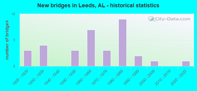
- New bridges - historical statistics
- 31920-1929
- 41930-1939
- 31950-1959
- 71960-1969
- 31970-1979
- 91980-1989
- 21990-1999
- 12000-2009
- 12020-2022
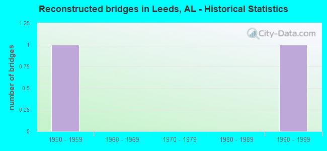
- Reconstructed bridges - Historical Statistics
- 11950-1959
- 01960-1969
- 01970-1979
- 01980-1989
- 11990-1999
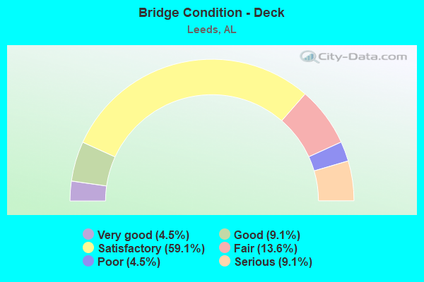
- Bridge Condition - Deck
- 4.5%Very good
- 9.1%Good
- 59.1%Satisfactory
- 13.6%Fair
- 4.5%Poor
- 9.1%Serious
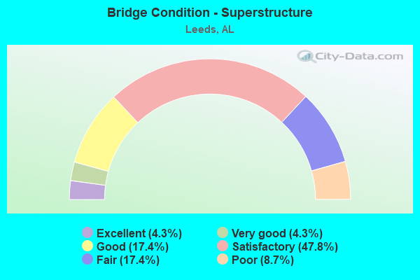
- Bridge Condition - Superstructure
- 4.3%Excellent
- 4.3%Very good
- 17.4%Good
- 47.8%Satisfactory
- 17.4%Fair
- 8.7%Poor
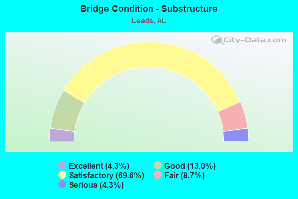
- Bridge Condition - Substructure
- 4.3%Excellent
- 13.0%Good
- 69.6%Satisfactory
- 8.7%Fair
- 4.3%Serious
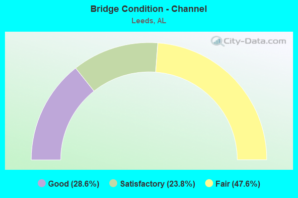
- Bridge Condition - Channel
- 28.6%Good
- 23.8%Satisfactory
- 47.6%Fair
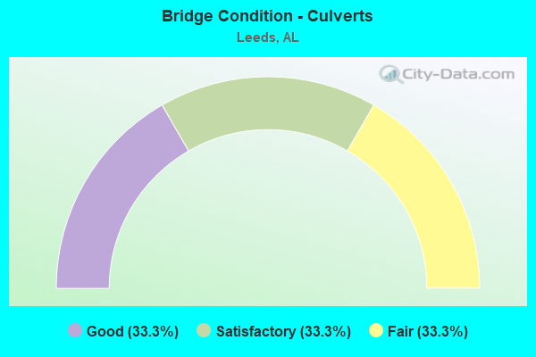
- Bridge Condition - Culverts
- 33.3%Good
- 33.3%Satisfactory
- 33.3%Fair
Find on map >> Show street view
Structure Number: 164, Location: 0.9 M N CO RD 520 (Lat: 32.959811, Lng: -85.677206), Route carried "on" structure: County highway 531, Year Built: 1920, Status: Posted for load, Structure Length: 2.53m (8.30ft), Average Daily Traffic: 105 (year 2008), Average Future Daily Traffic: 130 (year 2030), Features Intersected: SOAPSTONE CREEK, Facility Carried by Structure: BUTTSTON RD
Minimum Vertical Clearance: 30+ m (98+ ft), Kilometerpoint: 0.010, Lanes on structure: 1, Owner: County Highway Agency, Approaching Roadway Width: 6.1m (20.0ft), Material/Design: Steel, Design/Construction: Truss - Thru, Number Of Spans In Main Unit: 1, Length of Maximum Span: 25.3m (83.0ft), Curb-To-Curb Width: 4.8m (15.7ft), Out-to-Out Width: 5.5m (18.0ft)
Condition: Deck: Satisfactory, Superstructure: Poor, Substructure: Satisfactory, Channel: Satisfactory, Operating Rating: 4.5 metric tons, Method Used To Determine Operating Rating: Load Factor (LF), Inventory Rating: 3.4 metric tons, Method Used To Determine Inventory Rating: Load Factor (LF), Structural Evaluation: High priority of replacement, Deck Geometry: High priority of corrective action, Waterway Adequacy: Equal to present minimum criteria, Approach Roadway Alignment: Somewhat better than minimum adequacy, Bridge Posting: Required (Relationship of Operating Rating to Maximum Legal Load: > 39.9% below), Length Of Structure Improvement: 3.42m (11.22ft), Designated Inspection Frequency: Every 24 months, Critical Feature Inspection Frequency: Every 12 months, Other Special Inspection Frequency: Every 12 months, Inspection Date: November 2020, Critical Feature Inspection Date: November 2021, Other Special Inspection Date: November 2021, Bridge Improvement Cost: $398,000, Roadway Improvement Cost: $40,000, Total Project Cost: $438,000 ( Estimate for 2022), Deck Structure Type: Concrete Cast-file-Place
Find on map >> Show street view
Structure Number: 471, Location: .9 MI. E. AL 25 (Lat: 33.544383, Lng: -86.521900), Route carried "on" structure: US 78, Year Built: 1928, Status: Open, Structure Length: 0.98m (3.22ft), Average Daily Traffic: 4,260 (year 2020), Truck Traffic: 6%, Average Future Daily Traffic: 5,494 (year 2040), Features Intersected: BRANCH
Minimum Vertical Clearance: 30+ m (98+ ft), Kilometerpoint: 187.299, Lanes on structure: 2, Owner: State Highway Agency, Approaching Roadway Width: 7.3m (24.0ft), Material/Design: Concrete, Design/Construction: Culvert, Number Of Spans In Main Unit: 3, Length of Maximum Span: 2.4m (7.9ft)
Condition: Channel: Fair, Culverts: Fair, Operating Rating: 71.4 metric tons, Method Used To Determine Operating Rating: Load Factor (LF), Inventory Rating: 42.8 metric tons, Method Used To Determine Inventory Rating: Load Factor (LF), Structural Evaluation: Somewhat better than minimum adequacy, Waterway Adequacy: Meets minimum limits, Approach Roadway Alignment: Equal to present desirable criteria, Length Of Structure Improvement: 1.64m (5.38ft), Designated Inspection Frequency: Every 24 months, Inspection Date: November 2020, Bridge Improvement Cost: $304,000, Roadway Improvement Cost: $30,000, Total Project Cost: $334,000 ( Estimate for 2022), Wearing Surface/Protective System: Wearing Surface: Bituminous
Find on map >> Show street view
Structure Number: 884, Location: DOWNTOWN LEEDS (Lat: 33.546683, Lng: -86.548817), Route carried "on" structure: US 78, Year Built: 1931, Status: Open, Structure Length: 2.99m (9.81ft), Average Daily Traffic: 13,250 (year 2020), Truck Traffic: 5%, Average Future Daily Traffic: 17,088 (year 2040), Design Load: H 15, Features Intersected: LITTLE CAHABA RV
Minimum Vertical Clearance: 7.56m (24.80ft), Kilometerpoint: 184.609, Lanes on structure: 2, Owner: State Highway Agency, Approaching Roadway Width: 12.2m (40.0ft), Material/Design: Concrete continuous, Design/Construction: Slab, Number Of Spans In Main Unit: 8, Length of Maximum Span: 4.0m (13.1ft), Curb or Sidewalk Widths: Left: 1.2m (3.9ft), Right: 1.2m (3.9ft), Curb-To-Curb Width: 7.3m (24.0ft), Out-to-Out Width: 9.8m (32.2ft)
Condition: Deck: Fair, Superstructure: Satisfactory, Substructure: Satisfactory, Channel: Fair, Operating Rating: 48.6 metric tons, Method Used To Determine Operating Rating: Load Factor (LF), Inventory Rating: 29.1 metric tons, Method Used To Determine Inventory Rating: Load Factor (LF), Structural Evaluation: Equal to present minimum criteria, Deck Geometry: High priority of replacement, Waterway Adequacy: Somewhat better than minimum adequacy, Approach Roadway Alignment: Better than present minimum criteria, Length Of Structure Improvement: 3.88m (12.73ft), Designated Inspection Frequency: Every 24 months, Inspection Date: November 2020, Bridge Improvement Cost: $852,000, Roadway Improvement Cost: $85,000, Total Project Cost: $937,000 ( Estimate for 2022), Deck Structure Type: Concrete Cast-file-Place
Find on map >> Show street view
Structure Number: 1204, Location: .5 MI NW CO 15 CO 11 JCT (Lat: 34.559367, Lng: -88.117975), Route carried "on" structure: County highway 11, Year Built: 1935, Status: Posted for load, Structure Length: 0.98m (3.22ft), Average Daily Traffic: 170 (year 2000), Truck Traffic: 2%, Average Future Daily Traffic: 337 (year 2031), Features Intersected: RAMSEY MILL BRANCH
Minimum Vertical Clearance: 30+ m (98+ ft), Kilometerpoint: 0.010, Lanes on structure: 2, Owner: County Highway Agency, Approaching Roadway Width: 6.7m (22.0ft), Material/Design: Steel, Design/Construction: Stringer/Multi-beam, Number Of Spans In Main Unit: 1, Length of Maximum Span: 9.8m (32.2ft), Curb-To-Curb Width: 6.1m (20.0ft), Out-to-Out Width: 7.1m (23.3ft)
Condition: Deck: Serious, Superstructure: Fair, Substructure: Satisfactory, Channel: Satisfactory, Operating Rating: 2.7 metric tons, Method Used To Determine Operating Rating: Allowable Stress (AS), Inventory Rating: 1.8 metric tons, Method Used To Determine Inventory Rating: Allowable Stress (AS), Structural Evaluation: High priority of replacement, Deck Geometry: Meets minimum limits, Waterway Adequacy: Better than present minimum criteria, Approach Roadway Alignment: Equal to present desirable criteria, Bridge Posting: Required (Relationship of Operating Rating to Maximum Legal Load: > 39.9% below), Length Of Structure Improvement: 1.64m (5.38ft), Designated Inspection Frequency: Every 24 months, Other Special Inspection Frequency: Every 3 months, Inspection Date: January 2021, Other Special Inspection Date: January 2022, Bridge Improvement Cost: $259,000, Roadway Improvement Cost: $26,000, Total Project Cost: $285,000 ( Estimate for 2022), Deck Structure Type: Concrete Cast-file-Place, Wearing Surface/Protective System: Wearing Surface: Bituminous
Find on map >> Show street view
Structure Number: 1638, Location: COGBIL ST * ASHVILLE RD (Lat: 33.548000, Lng: -86.546400), Route carried "on" structure: City street , Year Built: 1937, Status: Closed, Structure Length: 1.40m (4.59ft), Average Daily Traffic: 75 (year 2015), Average Future Daily Traffic: 105 (year 2035), Design Load: H 10, Features Intersected: LIL CAHABA RV, Facility Carried by Structure: COGBIL ST
Minimum Vertical Clearance: 30+ m (98+ ft), Kilometerpoint: 1.799, Lanes on structure: 1, Owner: City or Municipal Highway Agency, Approaching Roadway Width: 3.0m (9.8ft), Material/Design: Concrete, Design/Construction: Tee Beam, Number Of Spans In Main Unit: 2, Length of Maximum Span: 9.1m (29.9ft), Curb-To-Curb Width: 3.3m (10.8ft), Out-to-Out Width: 3.7m (12.1ft)
Condition: Deck: Poor, Superstructure: Poor, Substructure: Fair, Channel: Fair, Waterway Adequacy: Equal to present minimum criteria, Approach Roadway Alignment: Equal to present minimum criteria, Bridge Posting: Required (Relationship of Operating Rating to Maximum Legal Load: > 39.9% below), Length Of Structure Improvement: 2.08m (6.82ft), Designated Inspection Frequency: Every 24 months, Critical Feature Inspection Frequency: Every 24 months, Other Special Inspection Frequency: Every 3 months, Inspection Date: July 2014, Critical Feature Inspection Date: January 2015, Other Special Inspection Date: January 2015, Bridge Improvement Cost: $171,000, Roadway Improvement Cost: $17,000, Total Project Cost: $188,000 ( Estimate for 2022), Deck Structure Type: Concrete Cast-file-Place
Find on map >> Show street view
Structure Number: 164, Location: LANE DR * ASHVILLE RD (Lat: 33.549700, Lng: -86.543000), Route carried "on" structure: City street , Year Built: 1937, Status: Posted for load, Structure Length: 1.40m (4.59ft), Average Daily Traffic: 1,060 (year 2021), Truck Traffic: 1%, Average Future Daily Traffic: 1,500 (year 2041), Design Load: H 15, Features Intersected: LIL CAHABA RV, Facility Carried by Structure: LANE DR
Minimum Vertical Clearance: 30+ m (98+ ft), Kilometerpoint: 1.899, Lanes on structure: 2, Owner: City or Municipal Highway Agency, Approaching Roadway Width: 7.8m (25.6ft), Skew: 4 degrees, Material/Design: Steel, Design/Construction: Stringer/Multi-beam, Number Of Spans In Main Unit: 3, Length of Maximum Span: 6.4m (21.0ft), Curb or Sidewalk Widths: Left: 1.2m (3.9ft), Right: 1.7m (5.6ft), Curb-To-Curb Width: 7.8m (25.6ft), Out-to-Out Width: 11.8m (38.7ft)
Condition: Deck: Fair, Superstructure: Satisfactory, Substructure: Satisfactory, Channel: Good, Operating Rating: 26.9 metric tons, Method Used To Determine Operating Rating: Allowable Stress (AS), Inventory Rating: 18.1 metric tons, Method Used To Determine Inventory Rating: Allowable Stress (AS), Structural Evaluation: Somewhat better than minimum adequacy, Deck Geometry: Meets minimum limits, Waterway Adequacy: Equal to present minimum criteria, Approach Roadway Alignment: Equal to present minimum criteria, Bridge Posting: Required (Relationship of Operating Rating to Maximum Legal Load: 30.0 - 39.9% below), Length Of Structure Improvement: 2.08m (6.82ft), Designated Inspection Frequency: Every 24 months, Other Special Inspection Frequency: Every 12 months, Inspection Date: March 2020, Other Special Inspection Date: March 2021, Bridge Improvement Cost: $541,000, Roadway Improvement Cost: $54,000, Total Project Cost: $595,000 ( Estimate for 2022), Deck Structure Type: Concrete Cast-file-Place
Find on map >> Show street view
Structure Number: 3925, Location: 0.4 MI MW AL 119 (Lat: 33.499989, Lng: -86.614447), Route carried "on" structure: County highway 309, Year Built: 1950, Status: Posted for load, Structure Length: 1.42m (4.66ft), Average Daily Traffic: 92 (year 2020), Average Future Daily Traffic: 100 (year 2040), Features Intersected: LITTLE CAHABA RIVER, Facility Carried by Structure: BAILEY ROAD
Minimum Vertical Clearance: 30+ m (98+ ft), Kilometerpoint: 0.100, Lanes on structure: 1, Owner: County Highway Agency, Approaching Roadway Width: 4.0m (13.1ft), Material/Design: Steel, Design/Construction: Girder and Floorbeam System, Number Of Spans In Main Unit: 1, Number Of Approach Spans: 1, Length of Maximum Span: 10.9m (35.8ft), Curb or Sidewalk Widths: Left: 0.1m (0.3ft), Right: 0.1m (0.3ft), Curb-To-Curb Width: 4.5m (14.8ft), Out-to-Out Width: 4.9m (16.1ft)
Condition: Deck: Satisfactory, Superstructure: Fair, Substructure: Satisfactory, Channel: Fair, Operating Rating: 14.5 metric tons, Method Used To Determine Operating Rating: Load Factor (LF), Inventory Rating: 10.9 metric tons, Method Used To Determine Inventory Rating: Load Factor (LF), Structural Evaluation: Meets minimum limits, Deck Geometry: Equal to present minimum criteria, Waterway Adequacy: Somewhat better than minimum adequacy, Approach Roadway Alignment: Somewhat better than minimum adequacy, Bridge Posting: Required (Relationship of Operating Rating to Maximum Legal Load: > 39.9% below), Length Of Structure Improvement: 2.10m (6.89ft), Designated Inspection Frequency: Every 24 months, Other Special Inspection Frequency: Every 12 months, Inspection Date: September 2020, Other Special Inspection Date: September 2021, Bridge Improvement Cost: $230,000, Roadway Improvement Cost: $23,000, Total Project Cost: $253,000 ( Estimate for 2022), Deck Structure Type: Wood or Timber, Wearing Surface/Protective System: Wearing Surface: Wood or Timber
Find on map >> Show street view
Structure Number: 477, Location: AL - 4 CAHABA RIVER (Lat: 33.545972, Lng: -86.613361), Route carried "on" structure: US 78, Year Built: 1955, Status: Open, Structure Length: 9.60m (31.50ft), Average Daily Traffic: 2,825 (year 2021), Truck Traffic: 5%, Average Future Daily Traffic: 3,643 (year 2041), Design Load: HS 20, Features Intersected: CAHABA RIVER
Minimum Vertical Clearance: 30+ m (98+ ft), Kilometerpoint: 178.026, Lanes on structure: 2, Owner: State Highway Agency, Approaching Roadway Width: 8.2m (26.9ft), Material/Design: Concrete continuous, Design/Construction: Tee Beam, Number Of Spans In Main Unit: 3, Number Of Approach Spans: 4, Length of Maximum Span: 21.3m (69.9ft), Curb-To-Curb Width: 8.5m (27.9ft), Out-to-Out Width: 10.1m (33.1ft)
Condition: Deck: Satisfactory, Superstructure: Satisfactory, Substructure: Satisfactory, Channel: Fair, Operating Rating: 37.7 metric tons, Method Used To Determine Operating Rating: Load Factor (LF), Inventory Rating: 22.6 metric tons, Method Used To Determine Inventory Rating: Load Factor (LF), Structural Evaluation: Equal to present minimum criteria, Deck Geometry: High priority of corrective action, Waterway Adequacy: Better than present minimum criteria, Approach Roadway Alignment: Better than present minimum criteria, Length Of Structure Improvement: 10.55m (34.61ft), Designated Inspection Frequency: Every 24 months, Inspection Date: June 2021, Bridge Improvement Cost: $2,387,000, Roadway Improvement Cost: $239,000, Total Project Cost: $2,626,000 ( Estimate for 2022), Deck Structure Type: Concrete Cast-file-Place
Find on map >> Show street view
Structure Number: 4771, Location: US 78 * CAHABA RV (Lat: 33.545861, Lng: -86.613361), Route carried "on" structure: US 78, Year Built: 1955, Status: Open, Structure Length: 9.61m (31.53ft), Average Daily Traffic: 2,825 (year 2020), Truck Traffic: 5%, Average Future Daily Traffic: 3,643 (year 2040), Design Load: HS 20, Features Intersected: CAHABA RV, Facility Carried by Structure: AL - 4 EAST
Minimum Vertical Clearance: 30+ m (98+ ft), Kilometerpoint: 178.026, Lanes on structure: 2, Owner: State Highway Agency, Approaching Roadway Width: 8.5m (27.9ft), Material/Design: Concrete continuous, Design/Construction: Tee Beam, Number Of Spans In Main Unit: 3, Number Of Approach Spans: 4, Length of Maximum Span: 21.3m (69.9ft), Curb-To-Curb Width: 8.5m (27.9ft), Out-to-Out Width: 10.1m (33.1ft)
Condition: Deck: Fair, Superstructure: Fair, Substructure: Fair, Channel: Fair, Operating Rating: 38.5 metric tons, Method Used To Determine Operating Rating: Load Factor (LF), Inventory Rating: 23.0 metric tons, Method Used To Determine Inventory Rating: Load Factor (LF), Structural Evaluation: Somewhat better than minimum adequacy, Deck Geometry: High priority of corrective action, Waterway Adequacy: Equal to present desirable criteria, Approach Roadway Alignment: Better than present minimum criteria, Length Of Structure Improvement: 10.56m (34.65ft), Designated Inspection Frequency: Every 24 months, Inspection Date: March 2020, Bridge Improvement Cost: $2,389,000, Roadway Improvement Cost: $239,000, Total Project Cost: $2,628,000 ( Estimate for 2022), Deck Structure Type: Concrete Cast-file-Place
Find on map >> Show street view
Structure Number: 5383, Location: AL 25 * US 78 (Lat: 33.540483, Lng: -86.534350), Route carried "on" structure: US 411, Year Built: 1924, Year Reconstructed: 1956, Status: Open, Structure Length: 1.10m (3.61ft), Average Daily Traffic: 3,580 (year 2021), Truck Traffic: 8%, Average Future Daily Traffic: 4,746 (year 2041), Features Intersected: BRANCH, Facility Carried by Structure: AL - 25
Minimum Vertical Clearance: 30+ m (98+ ft), Kilometerpoint: 272.385, Lanes on structure: 2, Owner: State Highway Agency, Approaching Roadway Width: 7.9m (25.9ft), Material/Design: Concrete, Design/Construction: Culvert, Number Of Spans In Main Unit: 3, Length of Maximum Span: 3.0m (9.8ft)
Condition: Channel: Satisfactory, Culverts: Good, Operating Rating: 41.2 metric tons, Method Used To Determine Operating Rating: Load Factor (LF), Inventory Rating: 24.8 metric tons, Method Used To Determine Inventory Rating: Load Factor (LF), Structural Evaluation: Equal to present minimum criteria, Waterway Adequacy: Equal to present minimum criteria, Approach Roadway Alignment: Equal to present desirable criteria, Length Of Structure Improvement: 1.77m (5.81ft), Designated Inspection Frequency: Every 24 months, Inspection Date: March 2021, Bridge Improvement Cost: $296,000, Roadway Improvement Cost: $30,000, Total Project Cost: $326,000 ( Estimate for 2022), Wearing Surface/Protective System: Wearing Surface: Bituminous
Find on map >> Show street view
Structure Number: 7213, Location: 0 . 6 MI E ST CLAIR CO LN (Lat: 33.563000, Lng: -86.541000), Route carried "on" structure: City street , Year Built: 1961, Status: Open, Structure Length: 6.98m (22.90ft), Average Daily Traffic: 868 (year 2020), Truck Traffic: 1%, Average Future Daily Traffic: 1,234 (year 2040), Design Load: HS 20, Features Intersected: I - 20, Facility Carried by Structure: DAWSON STREET
Minimum Vertical Clearance: 30+ m (98+ ft), Kilometerpoint: 0.010, Lanes on structure: 2, Lanes under structure: 6, Owner: State Highway Agency, Approaching Roadway Width: 10.4m (34.1ft), Material/Design: Concrete continuous, Design/Construction: Tee Beam, Number Of Spans In Main Unit: 4, Length of Maximum Span: 19.2m (63.0ft), Curb-To-Curb Width: 7.3m (24.0ft), Out-to-Out Width: 8.2m (26.9ft)
Condition: Deck: Satisfactory, Superstructure: Satisfactory, Substructure: Satisfactory, Operating Rating: 38.1 metric tons, Method Used To Determine Operating Rating: Load Factor (LF), Inventory Rating: 23.6 metric tons, Method Used To Determine Inventory Rating: Load Factor (LF), Structural Evaluation: Equal to present minimum criteria, Deck Geometry: Meets minimum limits, Underclear: Somewhat better than minimum adequacy, Approach Roadway Alignment: Equal to present minimum criteria, Length Of Structure Improvement: 8.01m (26.28ft), Designated Inspection Frequency: Every 24 months, Inspection Date: May 2020, Bridge Improvement Cost: $1,429,000, Roadway Improvement Cost: $143,000, Total Project Cost: $1,572,000 ( Estimate for 2022), Deck Structure Type: Concrete Cast-file-Place
Find on map >> Show street view
Structure Number: 7214, Location: .1 MI.W.US 411 (Lat: 33.559722, Lng: -86.525833), Route carried "on" structure: Interstate 20, Year Built: 1961, Year Reconstructed: 2003, Status: Open, Structure Length: 1.16m (3.81ft), Average Daily Traffic: 65,150 (year 2020), Truck Traffic: 24%, Average Future Daily Traffic: 78,712 (year 2040), Design Load: HS 20, Features Intersected: LITTLE CAHABA RIVER
Minimum Vertical Clearance: 30+ m (98+ ft), Kilometerpoint: 232.318, Lanes on structure: 8, Base Highway Network: Yes, Owner: State Highway Agency, Approaching Roadway Width: 39.2m (128.6ft), Skew: 14 degrees, Material/Design: Concrete, Design/Construction: Culvert, Number Of Spans In Main Unit: 3, Length of Maximum Span: 3.7m (12.1ft)
Condition: Channel: Good, Culverts: Satisfactory, Operating Rating: 43.8 metric tons, Method Used To Determine Operating Rating: Load Factor (LF), Inventory Rating: 26.2 metric tons, Method Used To Determine Inventory Rating: Load Factor (LF), Structural Evaluation: Equal to present minimum criteria, Waterway Adequacy: Better than present minimum criteria, Approach Roadway Alignment: Equal to present desirable criteria, Length Of Structure Improvement: 1.84m (6.04ft), Designated Inspection Frequency: Every 24 months, Inspection Date: April 2020, Bridge Improvement Cost: $2,004,000, Roadway Improvement Cost: $200,000, Total Project Cost: $2,204,000 ( Estimate for 2022), Wearing Surface/Protective System: Wearing Surface: Bituminous
Find on map >> Show street view
Structure Number: 7429, Location: PALMER AV * LIL CAHABA RV (Lat: 33.566667, Lng: -86.533333), Route carried "on" structure: City street , Year Built: 1961, Status: Open, Structure Length: 1.04m (3.41ft), Average Daily Traffic: 510 (year 2020), Truck Traffic: 1%, Average Future Daily Traffic: 1,000 (year 2040), Design Load: H 15, Features Intersected: LIL CAHABA RV, Facility Carried by Structure: PALMER AVE
Minimum Vertical Clearance: 30+ m (98+ ft), Kilometerpoint: 2.300, Lanes on structure: 2, Owner: City or Municipal Highway Agency, Approaching Roadway Width: 5.6m (18.4ft), Material/Design: Concrete, Design/Construction: Channel Beam, Number Of Spans In Main Unit: 1, Length of Maximum Span: 10.4m (34.1ft), Curb-To-Curb Width: 6.4m (21.0ft), Out-to-Out Width: 7.0m (23.0ft)
Condition: Deck: Satisfactory, Superstructure: Good, Substructure: Satisfactory, Channel: Satisfactory, Operating Rating: 49.8 metric tons, Method Used To Determine Operating Rating: Load Factor (LF), Inventory Rating: 29.8 metric tons, Method Used To Determine Inventory Rating: Load Factor (LF), Structural Evaluation: Equal to present minimum criteria, Deck Geometry: High priority of corrective action, Waterway Adequacy: Equal to present minimum criteria, Approach Roadway Alignment: Equal to present desirable criteria, Length Of Structure Improvement: 1.71m (5.61ft), Designated Inspection Frequency: Every 24 months, Inspection Date: March 2020, Bridge Improvement Cost: $269,000, Roadway Improvement Cost: $27,000, Total Project Cost: $296,000 ( Estimate for 2022), Deck Structure Type: Concrete Precast Panels
Find on map >> Show street view
Structure Number: 8393, Location: 1500' E AL 119 (Lat: 33.524519, Lng: -86.575411), Route carried "on" structure: County highway 75, Year Built: 1964, Status: Open, Structure Length: 2.93m (9.61ft), Average Daily Traffic: 2,468 (year 2020), Truck Traffic: 5%, Average Future Daily Traffic: 3,400 (year 2040), Design Load: HS 20, Features Intersected: LITTLE CAHABA RIVER, Facility Carried by Structure: ELLIOT LANE(LEEDS)
Minimum Vertical Clearance: 30+ m (98+ ft), Kilometerpoint: 0.010, Lanes on structure: 2, Owner: County Highway Agency, Approaching Roadway Width: 6.2m (20.3ft), Skew: 3 degrees, Material/Design: Concrete, Design/Construction: Channel Beam, Number Of Spans In Main Unit: 3, Length of Maximum Span: 9.1m (29.9ft), Curb or Sidewalk Widths: Left: 0.3m (1.0ft), Right: 0.3m (1.0ft), Curb-To-Curb Width: 6.9m (22.6ft), Out-to-Out Width: 7.4m (24.3ft)
Condition: Deck: Satisfactory, Superstructure: Satisfactory, Substructure: Satisfactory, Channel: Fair, Operating Rating: 47.6 metric tons, Method Used To Determine Operating Rating: Load Factor (LF), Inventory Rating: 28.5 metric tons, Method Used To Determine Inventory Rating: Load Factor (LF), Structural Evaluation: Equal to present minimum criteria, Deck Geometry: High priority of replacement, Waterway Adequacy: Equal to present minimum criteria, Approach Roadway Alignment: Better than present minimum criteria, Length Of Structure Improvement: 3.84m (12.60ft), Designated Inspection Frequency: Every 24 months, Inspection Date: June 2020, Bridge Improvement Cost: $631,000, Roadway Improvement Cost: $63,000, Total Project Cost: $694,000 ( Estimate for 2022), Deck Structure Type: Concrete Precast Panels, Wearing Surface/Protective System: Wearing Surface: Bituminous
Find on map >> Show street view
Structure Number: 10785, Location: 0.5 MI N US 78 (LOVICK) (Lat: 33.553833, Lng: -86.618117), Route carried "on" structure: County highway 96, Year Built: 1972, Status: Open, Structure Length: 5.04m (16.54ft), Average Daily Traffic: 4,755 (year 2020), Truck Traffic: 5%, Average Future Daily Traffic: 6,640 (year 2040), Design Load: HS 20, Features Intersected: NORFOLK SO RR, Facility Carried by Structure: FLOYD BRADFORD RD
Minimum Vertical Clearance: 30+ m (98+ ft), Kilometerpoint: 0.010, Lanes on structure: 2, Owner: County Highway Agency, Approaching Roadway Width: 7.4m (24.3ft), Material/Design: Steel, Design/Construction: Stringer/Multi-beam, Number Of Spans In Main Unit: 3, Length of Maximum Span: 18.3m (60.0ft), Curb or Sidewalk Widths: Left: 0.2m (0.7ft), Right: 0.2m (0.7ft), Curb-To-Curb Width: 8.4m (27.6ft), Out-to-Out Width: 9.7m (31.8ft)
Condition: Deck: Satisfactory, Superstructure: Good, Substructure: Good, Operating Rating: 77.2 metric tons, Method Used To Determine Operating Rating: Load Factor (LF), Inventory Rating: 46.3 metric tons, Method Used To Determine Inventory Rating: Load Factor (LF), Structural Evaluation: Better than present minimum criteria, Deck Geometry: High priority of corrective action, Underclear: Equal to present minimum criteria, Approach Roadway Alignment: Better than present minimum criteria, Length Of Structure Improvement: 6.05m (19.85ft), Designated Inspection Frequency: Every 24 months, Inspection Date: November 2020, Bridge Improvement Cost: $1,287,000, Roadway Improvement Cost: $129,000, Total Project Cost: $1,416,000 ( Estimate for 2022), Deck Structure Type: Concrete Cast-file-Place
Find on map >> Show street view
Structure Number: 11482, Location: VIVIAN ST * LIL CAHABA RV (Lat: 33.550000, Lng: -86.566667), Route carried "on" structure: City street , Year Built: 1975, Status: Open, Structure Length: 1.43m (4.69ft), Average Daily Traffic: 720 (year 2020), Truck Traffic: 1%, Average Future Daily Traffic: 1,500 (year 2040), Design Load: H 15, Features Intersected: LIL CAHABA RV, Facility Carried by Structure: VIVIAN ST
Minimum Vertical Clearance: 30+ m (98+ ft), Kilometerpoint: 0.698, Lanes on structure: 2, Owner: City or Municipal Highway Agency, Approaching Roadway Width: 6.4m (21.0ft), Skew: 3 degrees, Material/Design: Concrete, Design/Construction: Tee Beam, Number Of Spans In Main Unit: 1, Length of Maximum Span: 14.3m (46.9ft), Curb-To-Curb Width: 9.2m (30.2ft), Out-to-Out Width: 9.7m (31.8ft)
Condition: Deck: Good, Superstructure: Good, Substructure: Satisfactory, Channel: Fair, Operating Rating: 43.5 metric tons, Method Used To Determine Operating Rating: Field evaluation and documented engineering judgment, Inventory Rating: 32.7 metric tons, Method Used To Determine Inventory Rating: Field evaluation and documented engineering judgment, Structural Evaluation: Equal to present minimum criteria, Deck Geometry: Equal to present minimum criteria, Waterway Adequacy: Equal to present minimum criteria, Approach Roadway Alignment: Equal to present desirable criteria, Length Of Structure Improvement: 2.11m (6.92ft), Designated Inspection Frequency: Every 24 months, Inspection Date: March 2020, Bridge Improvement Cost: $448,000, Roadway Improvement Cost: $45,000, Total Project Cost: $493,000 ( Estimate for 2022), Deck Structure Type: Concrete Precast Panels, Wearing Surface/Protective System: Wearing Surface: Bituminous
Find on map >> Show street view
Structure Number: 1204, Location: JONES ST * LIL CAHABA RV (Lat: 33.555383, Lng: -86.534672), Route carried "on" structure: City street , Year Built: 1978, Status: Closed, Structure Length: 0.79m (2.59ft), Average Daily Traffic: 10 (year 2022), Average Future Daily Traffic: 17 (year 2042), Design Load: H 10, Features Intersected: LIL CAHABA RV, Facility Carried by Structure: JONES ST
Minimum Vertical Clearance: 30+ m (98+ ft), Kilometerpoint: 1.999, Lanes on structure: 1, Owner: City or Municipal Highway Agency, Approaching Roadway Width: 4.0m (13.1ft), Skew: 3 degrees, Material/Design: Steel, Design/Construction: Stringer/Multi-beam, Number Of Spans In Main Unit: 1, Length of Maximum Span: 7.9m (25.9ft), Curb-To-Curb Width: 4.3m (14.1ft), Out-to-Out Width: 4.7m (15.4ft)
Condition: Deck: Serious, Superstructure: Fair, Substructure: Serious, Channel: Fair, Deck Geometry: Equal to present minimum criteria, Waterway Adequacy: Meets minimum limits, Approach Roadway Alignment: High priority of corrective action, Bridge Posting: Required (Relationship of Operating Rating to Maximum Legal Load: > 39.9% below), Length Of Structure Improvement: 1.45m (4.76ft), Designated Inspection Frequency: Every 24 months, Other Special Inspection Frequency: Every 3 months, Inspection Date: March 2020, Other Special Inspection Date: January 2022, Bridge Improvement Cost: $149,000, Roadway Improvement Cost: $15,000, Total Project Cost: $164,000 ( Estimate for 2022), Deck Structure Type: Wood or Timber, Wearing Surface/Protective System: Wearing Surface: Wood or Timber
Find on map >> Show street view
Structure Number: 13173, Location: RIVERVIEW RD * I20 (Lat: 33.545642, Lng: -86.620342), Route carried "on" structure: County highway , Year Built: 1984, Status: Open, Structure Length: 10.79m (35.40ft), Average Daily Traffic: 1,000 (year 2021), Truck Traffic: 2%, Average Future Daily Traffic: 1,500 (year 2041), Design Load: HS 20, Features Intersected: I20, Facility Carried by Structure: RIVERVIEW ROAD
Minimum Vertical Clearance: 30+ m (98+ ft), Kilometerpoint: 0.010, Lanes on structure: 2, Lanes under structure: 6, Owner: State Highway Agency, Approaching Roadway Width: 13.4m (44.0ft), Skew: 2 degrees, Material/Design: Steel continuous, Design/Construction: Stringer/Multi-beam, Number Of Spans In Main Unit: 4, Length of Maximum Span: 34.1m (111.9ft), Curb-To-Curb Width: 8.6m (28.2ft), Out-to-Out Width: 9.4m (30.8ft)
Condition: Deck: Satisfactory, Superstructure: Satisfactory, Substructure: Satisfactory, Operating Rating: 55.1 metric tons, Method Used To Determine Operating Rating: Load Factor (LF), Inventory Rating: 32.9 metric tons, Method Used To Determine Inventory Rating: Load Factor (LF), Structural Evaluation: Equal to present minimum criteria, Deck Geometry: Somewhat better than minimum adequacy, Underclear: Equal to present minimum criteria, Approach Roadway Alignment: Equal to present minimum criteria, Length Of Structure Improvement: 11.69m (38.35ft), Designated Inspection Frequency: Every 24 months, Inspection Date: Febuary 2021, Bridge Improvement Cost: $2,404,000, Roadway Improvement Cost: $240,000, Total Project Cost: $2,644,000 ( Estimate for 2022), Deck Structure Type: Concrete Cast-file-Place
Find on map >> Show street view
Structure Number: 13174, Location: I20 * CAHABA RIVER (Lat: 33.544500, Lng: -86.616600), Route carried "on" structure: Interstate 20, Year Built: 1984, Status: Open, Structure Length: 18.26m (59.91ft), Average Daily Traffic: 35,000 (year 2020), Truck Traffic: 21%, Average Future Daily Traffic: 42,286 (year 2040), Design Load: HS 20, Features Intersected: CAHABA RIVER
Minimum Vertical Clearance: 30+ m (98+ ft), Kilometerpoint: 222.781, Lanes on structure: 3, Base Highway Network: Yes, Owner: State Highway Agency, Approaching Roadway Width: 18.9m (62.0ft), Material/Design: Steel, Design/Construction: Stringer/Multi-beam, Number Of Spans In Main Unit: 4, Length of Maximum Span: 57.9m (190.0ft), Curb-To-Curb Width: 17.1m (56.1ft), Out-to-Out Width: 18.0m (59.1ft)
Condition: Deck: Satisfactory, Superstructure: Satisfactory, Substructure: Satisfactory, Channel: Good, Operating Rating: 72.2 metric tons, Method Used To Determine Operating Rating: Load Factor (LF), Inventory Rating: 43.3 metric tons, Method Used To Determine Inventory Rating: Load Factor (LF), Structural Evaluation: Equal to present minimum criteria, Deck Geometry: Equal to present minimum criteria, Waterway Adequacy: Equal to present desirable criteria, Approach Roadway Alignment: Equal to present desirable criteria, Length Of Structure Improvement: 18.93m (62.11ft), Designated Inspection Frequency: Every 24 months, Inspection Date: October 2020, Bridge Improvement Cost: $7,657,000, Roadway Improvement Cost: $766,000, Total Project Cost: $8,423,000 ( Estimate for 2022), Deck Structure Type: Concrete Cast-file-Place
Find on map >> Show street view
Structure Number: 13175, Location: I20 * CAHABA RIVER (Lat: 33.544800, Lng: -86.618400), Route carried "on" structure: Interstate 20, Year Built: 1984, Status: Open, Structure Length: 22.56m (74.02ft), Average Daily Traffic: 35,000 (year 2020), Truck Traffic: 21%, Average Future Daily Traffic: 42,286 (year 2040), Design Load: HS 20, Features Intersected: CAHABA RIVER
Minimum Vertical Clearance: 30+ m (98+ ft), Kilometerpoint: 222.798, Lanes on structure: 3, Base Highway Network: Yes, Owner: State Highway Agency, Approaching Roadway Width: 18.9m (62.0ft), Material/Design: Steel, Design/Construction: Stringer/Multi-beam, Number Of Spans In Main Unit: 5, Length of Maximum Span: 57.9m (190.0ft), Curb-To-Curb Width: 17.1m (56.1ft), Out-to-Out Width: 18.0m (59.1ft)
Condition: Deck: Satisfactory, Superstructure: Satisfactory, Substructure: Satisfactory, Channel: Good, Operating Rating: 36.2 metric tons, Method Used To Determine Operating Rating: Load Factor (LF), Inventory Rating: 21.7 metric tons, Method Used To Determine Inventory Rating: Load Factor (LF), Structural Evaluation: Somewhat better than minimum adequacy, Deck Geometry: Equal to present minimum criteria, Waterway Adequacy: Superior to present desirable criteria, Approach Roadway Alignment: Equal to present desirable criteria, Length Of Structure Improvement: 22.56m (74.02ft), Designated Inspection Frequency: Every 24 months, Inspection Date: October 2020, Bridge Improvement Cost: $9,125,000, Roadway Improvement Cost: $913,000, Total Project Cost: $10,038,000 ( Estimate for 2022), Deck Structure Type: Concrete Cast-file-Place
Find on map >> Show street view
Structure Number: 13527, Location: I20 * US 78 LEEDS (Lat: 33.544800, Lng: -86.592600), Route carried "on" structure: Interstate 20, Year Built: 1985, Status: Open, Structure Length: 11.83m (38.81ft), Average Daily Traffic: 35,000 (year 2020), Truck Traffic: 21%, Average Future Daily Traffic: 42,286 (year 2040), Design Load: HS 20, Features Intersected: AL - 4 (US 78)
Minimum Vertical Clearance: 30+ m (98+ ft), Kilometerpoint: 225.326, Lanes on structure: 3, Lanes under structure: 4, Base Highway Network: Yes, Owner: State Highway Agency, Approaching Roadway Width: 21.9m (71.9ft), Skew: 4 degrees, Material/Design: Steel, Design/Construction: Stringer/Multi-beam, Number Of Spans In Main Unit: 4, Length of Maximum Span: 32.0m (105.0ft), Curb-To-Curb Width: 15.8m (51.8ft), Out-to-Out Width: 16.7m (54.8ft)
Condition: Deck: Satisfactory, Superstructure: Satisfactory, Substructure: Satisfactory, Operating Rating: 58.4 metric tons, Method Used To Determine Operating Rating: Load Factor (LF), Inventory Rating: 35.0 metric tons, Method Used To Determine Inventory Rating: Load Factor (LF), Structural Evaluation: Equal to present minimum criteria, Deck Geometry: Somewhat better than minimum adequacy, Underclear: Somewhat better than minimum adequacy, Approach Roadway Alignment: Better than present minimum criteria, Length Of Structure Improvement: 12.69m (41.63ft), Designated Inspection Frequency: Every 24 months, Inspection Date: December 2020, Bridge Improvement Cost: $4,698,000, Roadway Improvement Cost: $470,000, Total Project Cost: $5,168,000 ( Estimate for 2022), Deck Structure Type: Concrete Cast-file-Place
Find on map >> Show street view
Structure Number: 13528, Location: I20 * US 78 (Lat: 33.544700, Lng: -86.592400), Route carried "on" structure: Interstate 20, Year Built: 1985, Status: Open, Structure Length: 11.83m (38.81ft), Average Daily Traffic: 35,000 (year 2020), Truck Traffic: 21%, Average Future Daily Traffic: 42,286 (year 2040), Design Load: HS 20, Features Intersected: AL - 4 ( US 78)
Minimum Vertical Clearance: 30+ m (98+ ft), Kilometerpoint: 225.326, Lanes on structure: 3, Lanes under structure: 5, Base Highway Network: Yes, Owner: State Highway Agency, Approaching Roadway Width: 21.9m (71.9ft), Skew: 4 degrees, Material/Design: Steel, Design/Construction: Stringer/Multi-beam, Number Of Spans In Main Unit: 4, Length of Maximum Span: 32.0m (105.0ft), Curb-To-Curb Width: 15.8m (51.8ft), Out-to-Out Width: 16.7m (54.8ft)
Condition: Deck: Satisfactory, Superstructure: Satisfactory, Substructure: Satisfactory, Operating Rating: 61.4 metric tons, Method Used To Determine Operating Rating: Allowable Stress (AS), Inventory Rating: 38.6 metric tons, Method Used To Determine Inventory Rating: Allowable Stress (AS), Structural Evaluation: Equal to present minimum criteria, Deck Geometry: Somewhat better than minimum adequacy, Underclear: Equal to present minimum criteria, Approach Roadway Alignment: Equal to present desirable criteria, Length Of Structure Improvement: 12.69m (41.63ft), Designated Inspection Frequency: Every 24 months, Inspection Date: December 2020, Bridge Improvement Cost: $4,698,000, Roadway Improvement Cost: $470,000, Total Project Cost: $5,168,000 ( Estimate for 2022), Deck Structure Type: Concrete Cast-file-Place
Find on map >> Show street view
Structure Number: 16892, Location: AL 119 * LITTLE CAHABA RI (Lat: 33.515000, Lng: -86.586667), Route carried "on" structure: State highway 119, Year Built: 1999, Status: Open, Structure Length: 5.02m (16.47ft), Average Daily Traffic: 6,200 (year 2021), Truck Traffic: 9%, Average Future Daily Traffic: 8,139 (year 2041), Design Load: HS 20, Features Intersected: LITTLE CAHABA RIVER
Minimum Vertical Clearance: 7.56m (24.80ft), Kilometerpoint: 58.580, Lanes on structure: 2, Owner: State Highway Agency, Approaching Roadway Width: 12.2m (40.0ft), Skew: 3 degrees, Material/Design: Prestressed concrete, Design/Construction: Stringer/Multi-beam, Number Of Spans In Main Unit: 3, Length of Maximum Span: 16.7m (54.8ft), Curb-To-Curb Width: 13.4m (44.0ft), Out-to-Out Width: 14.2m (46.6ft)
Condition: Deck: Good, Superstructure: Good, Substructure: Good, Channel: Good, Operating Rating: 69.9 metric tons, Method Used To Determine Operating Rating: Load Factor (LF), Inventory Rating: 41.8 metric tons, Method Used To Determine Inventory Rating: Load Factor (LF), Structural Evaluation: Better than present minimum criteria, Deck Geometry: Equal to present minimum criteria, Waterway Adequacy: Equal to present desirable criteria, Approach Roadway Alignment: Equal to present desirable criteria, Length Of Structure Improvement: 6.04m (19.82ft), Designated Inspection Frequency: Every 24 months, Inspection Date: March 2021, Bridge Improvement Cost: $1,904,000, Roadway Improvement Cost: $190,000, Total Project Cost: $2,094,000 ( Estimate for 2022), Deck Structure Type: Concrete Cast-file-Place
Find on map >> Show street view
Structure Number: 19298, Location: .1 MILE FROM US 411 00 (Lat: 33.555133, Lng: -86.534728), Route carried "on" structure: City street , Year Built: 1992, Status: Open, Structure Length: 2.21m (7.25ft), Average Daily Traffic: 500 (year 2020), Average Future Daily Traffic: 700 (year 2040), Design Load: HS 20, Features Intersected: L LITTLE CAHABA RIVER, Facility Carried by Structure: OLIVER ROAD
Minimum Vertical Clearance: 30+ m (98+ ft), Kilometerpoint: 0.000, Lanes on structure: 2, Owner: City or Municipal Highway Agency, Approaching Roadway Width: 7.4m (24.3ft), Material/Design: Prestressed concrete, Design/Construction: Stringer/Multi-beam, Number Of Spans In Main Unit: 1, Length of Maximum Span: 22.1m (72.5ft), Curb-To-Curb Width: 7.5m (24.6ft), Out-to-Out Width: 8.3m (27.2ft)
Condition: Deck: Very good, Superstructure: Very good, Substructure: Good, Channel: Fair, Operating Rating: 71.7 metric tons, Method Used To Determine Operating Rating: Load Factor (LF), Inventory Rating: 48.0 metric tons, Method Used To Determine Inventory Rating: Load Factor (LF), Structural Evaluation: Better than present minimum criteria, Deck Geometry: Meets minimum limits, Waterway Adequacy: Equal to present desirable criteria, Approach Roadway Alignment: Equal to present desirable criteria, Length Of Structure Improvement: 3.01m (9.88ft), Designated Inspection Frequency: Every 24 months, Inspection Date: March 2020, Bridge Improvement Cost: $557,000, Roadway Improvement Cost: $56,000, Total Project Cost: $613,000 ( Estimate for 2022), Deck Structure Type: Concrete Cast-file-Place
Find on map >> Show street view
Structure Number: 20894, Location: 0.6 MI E OF AL 119 (Lat: 33.541181, Lng: -86.538003), Route carried "on" structure: City street , Year Built: 1985, Status: Open, Structure Length: 0.73m (2.40ft), Average Daily Traffic: 300 (year 2022), Average Future Daily Traffic: 420 (year 2042), Design Load: HS 20, Features Intersected: BRANCH, Facility Carried by Structure: NO NAME ST
Minimum Vertical Clearance: 30+ m (98+ ft), Kilometerpoint: 0.097, Lanes on structure: 2, Owner: City or Municipal Highway Agency, Approaching Roadway Width: 6.1m (20.0ft), Material/Design: Concrete, Design/Construction: Tee Beam, Number Of Spans In Main Unit: 1, Length of Maximum Span: 7.3m (24.0ft), Curb-To-Curb Width: 7.5m (24.6ft), Out-to-Out Width: 8.3m (27.2ft)
Condition: Deck: Satisfactory, Superstructure: Satisfactory, Substructure: Satisfactory, Channel: Satisfactory, Operating Rating: 46.1 metric tons, Method Used To Determine Operating Rating: Load Factor (LF), Inventory Rating: 27.7 metric tons, Method Used To Determine Inventory Rating: Load Factor (LF), Structural Evaluation: Equal to present minimum criteria, Deck Geometry: Somewhat better than minimum adequacy, Waterway Adequacy: Equal to present minimum criteria, Approach Roadway Alignment: Better than present minimum criteria, Length Of Structure Improvement: 1.38m (4.53ft), Designated Inspection Frequency: Every 24 months, Inspection Date: January 2022, Bridge Improvement Cost: $255,000, Roadway Improvement Cost: $26,000, Total Project Cost: $281,000 ( Estimate for 2022), Deck Structure Type: Concrete Cast-file-Place
Find on map >> Show street view
Structure Number: 21424, Location: 1.8 miles NE US 78 Leeds (Lat: 33.568978, Lng: -86.604044), Route carried "on" structure: County highway 96, Year Built: 2020, Status: Open, Structure Length: 0.85m (2.79ft), Average Daily Traffic: 4,551 (year 2020), Truck Traffic: 3%, Average Future Daily Traffic: 5,000 (year 2040), Design Load: HS 20, Features Intersected: Stinking Creek, Facility Carried by Structure: Floyd Bradford Rd
Minimum Vertical Clearance: 30+ m (98+ ft), Kilometerpoint: 0.000, Lanes on structure: 2, Owner: County Highway Agency, Approaching Roadway Width: 6.9m (22.6ft), Material/Design: Prestressed concrete, Design/Construction: Arch - Deck, Number Of Spans In Main Unit: 1, Length of Maximum Span: 8.5m (27.9ft), Curb-To-Curb Width: 6.9m (22.6ft), Out-to-Out Width: 34.6m (113.5ft)
Condition: Superstructure: Excellent, Substructure: Excellent, Channel: Good, Operating Rating: 82.7 metric tons, Method Used To Determine Operating Rating: Load and Resistance Factor (LRFR), Inventory Rating: 62.1 metric tons, Method Used To Determine Inventory Rating: Load and Resistance Factor (LRFR), Structural Evaluation: Superior to present desirable criteria, Deck Geometry: High priority of replacement, Approach Roadway Alignment: Equal to present minimum criteria, Length Of Structure Improvement: 1.52m (4.99ft), Designated Inspection Frequency: Every 24 months, Inspection Date: September 2020, Bridge Improvement Cost: $1,177,000, Roadway Improvement Cost: $118,000, Total Project Cost: $1,295,000 ( Estimate for 2022)
Find on map >> Show street view
Structure Number: 1184, Location: LEEDS (Lat: 33.540858, Lng: -86.535033), Route carried "under" structure: Other road 4, Year Built: 2005, Structure Length: 0. m, Average Daily Traffic: 6,280 (year 2013), Truck Traffic: 5%, Features Intersected: US 78, Facility Carried by Structure: RR
Minimum Vertical Clearance: 7.68m (25.20ft), Kilometerpoint: 185.718, Lanes under structure: 2, Material/Design: Steel, Design/Construction: Stringer/Multi-beam, Length of Maximum Span: 11.0m (36.1ft)
Find on map >> Show street view
Structure Number: 7211, Location: I-20 * C OF GA RR (Lat: 33.555367, Lng: -86.571447), Route carried "under" structure: Other road 20, Year Built: 1961, Structure Length: 0. m, Average Daily Traffic: 65,150 (year 2013), Truck Traffic: 24%, Features Intersected: I-20, Facility Carried by Structure: NS RR
Minimum Vertical Clearance: 4.97m (16.31ft), Kilometerpoint: 229.090, Lanes under structure: 6, Material/Design: Steel, Design/Construction: Stringer/Multi-beam, Length of Maximum Span: 19.2m (63.0ft)
Find on map >> Show street view
Structure Number: 7212, Location: I-20*SOU RR (Lat: 33.555000, Lng: -86.571944), Route carried "under" structure: Other road 20, Year Built: 1961, Structure Length: 0. m, Average Daily Traffic: 65,150 (year 2013), Truck Traffic: 24%, Features Intersected: I-20, Facility Carried by Structure: SOUTHERN RR
Minimum Vertical Clearance: 4.82m (15.81ft), Kilometerpoint: 228.575, Lanes under structure: 6, Material/Design: Steel, Design/Construction: Stringer/Multi-beam, Length of Maximum Span: 17.1m (56.1ft)
Find on map >> Show street view
Structure Number: 7213, Location: 0 . 6 MI E ST CLAIR CO LN (Lat: 33.563000, Lng: -86.541000), Route carried "under" structure: Interstate 20, Year Built: 1961, Structure Length: 0. m, Average Daily Traffic: 65,150 (year 2020), Truck Traffic: 24%, Features Intersected: I - 20, Facility Carried by Structure: DAWSON STREET
Minimum Vertical Clearance: 5.79m (19.00ft), Kilometerpoint: 230.777, Lanes on structure: 2, Lanes under structure: 6, Material/Design: Concrete continuous, Design/Construction: Tee Beam, Length of Maximum Span: 19.2m (63.0ft)
Find on map >> Show street view
Structure Number: 13173, Location: RIVERVIEW RD * I20 (Lat: 33.545642, Lng: -86.620342), Route carried "under" structure: Interstate 20, Year Built: 1984, Structure Length: 0. m, Average Daily Traffic: 70,937 (year 2021), Truck Traffic: 21%, Features Intersected: I20, Facility Carried by Structure: RIVERVIEW ROAD
Minimum Vertical Clearance: 5.31m (17.42ft), Kilometerpoint: 223.427, Lanes on structure: 2, Lanes under structure: 6, Material/Design: Steel continuous, Design/Construction: Stringer/Multi-beam, Length of Maximum Span: 34.1m (111.9ft)
Find on map >> Show street view
Structure Number: 13527, Location: I20 * US 78 LEEDS (Lat: 33.544800, Lng: -86.592600), Route carried "under" structure: US 78, Year Built: 1985, Structure Length: 0. m, Average Daily Traffic: 2,790 (year 2020), Truck Traffic: 7%, Features Intersected: AL - 4 (US 78), Facility Carried by Structure: I - 20 WEST
Minimum Vertical Clearance: 5.61m (18.41ft), Kilometerpoint: 179.925, Lanes on structure: 3, Lanes under structure: 4, Material/Design: Steel, Design/Construction: Stringer/Multi-beam, Length of Maximum Span: 32.0m (105.0ft)
Find on map >> Show street view
Structure Number: 13528, Location: I20 * US 78 (Lat: 33.544700, Lng: -86.592400), Route carried "under" structure: US 78, Year Built: 1985, Structure Length: 0. m, Average Daily Traffic: 2,790 (year 2020), Truck Traffic: 7%, Features Intersected: AL - 4 ( US 78), Facility Carried by Structure: I - 20 EAST
Minimum Vertical Clearance: 5.18m (16.99ft), Kilometerpoint: 179.925, Lanes on structure: 3, Lanes under structure: 4, Material/Design: Steel, Design/Construction: Stringer/Multi-beam, Length of Maximum Span: 32.0m (105.0ft)