Bridge Statistics for Leighton, Alabama (AL)
Condition, Traffic, Stress, Structural Evaluation, Project Costs
- National Bridge Inventory (NBI) Statistics
- 31Number of bridges
- 354ft / 108mTotal length
- $30,448,000Total costs
- 99,785Total average daily traffic
- 7,634Total average daily truck traffic
- 137,471Total future (year 2033) average daily traffic
- National Bridge Inventory (NBI) Registered Bridges for Leighton
- No street view available for this location
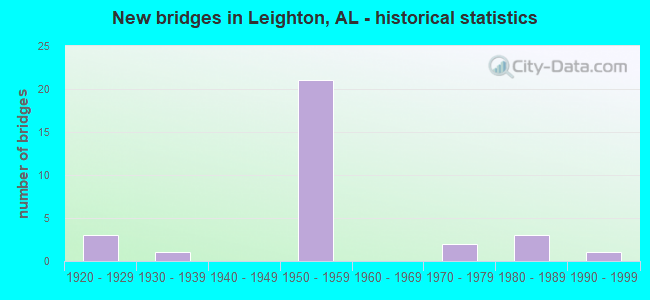
- New bridges - historical statistics
- 31920-1929
- 11930-1939
- 211950-1959
- 21970-1979
- 31980-1989
- 11990-1999

- Reconstructed bridges - Historical Statistics
- 21980-1989
- 01990-1999
- 12000-2009


- Bridge Condition - Deck
- 5.9%Very good
- 29.4%Good
- 47.1%Satisfactory
- 17.6%Fair

- Bridge Condition - Superstructure
- 5.9%Very good
- 47.1%Good
- 17.6%Satisfactory
- 29.4%Fair

- Bridge Condition - Substructure
- 11.8%Very good
- 29.4%Good
- 29.4%Satisfactory
- 29.4%Fair

- Bridge Condition - Channel
- 3.2%Excellent
- 6.5%Very good
- 35.5%Good
- 35.5%Satisfactory
- 12.9%Fair
- 6.5%Poor

- Bridge Condition - Culverts
- 7.1%Excellent
- 28.6%Good
- 64.3%Satisfactory
Find on map >> Show street view
Structure Number: 462, Location: 3.8 MI E JCT SR 2 & I 65 (Lat: 34.765000, Lng: -86.878333), Route carried "on" structure: US 72, Year Built: 1928, Status: Open, Structure Length: 2.26m (7.41ft), Average Daily Traffic: 9,320 (year 2020), Truck Traffic: 3%, Average Future Daily Traffic: 11,327 (year 2033), Design Load: H 15, Features Intersected: FRENCH MILL CREEK, Facility Carried by Structure: SR 2
Minimum Vertical Clearance: 30+ m (98+ ft), Kilometerpoint: 129.369, Lanes on structure: 2, Base Highway Network: Yes, Owner: State Highway Agency, Approaching Roadway Width: 7.3m (24.0ft), Skew: 10 degrees, Material/Design: Concrete continuous, Design/Construction: Slab, Number Of Spans In Main Unit: 4, Length of Maximum Span: 6.4m (21.0ft), Curb or Sidewalk Widths: Left: 0.5m (1.6ft), Right: 0.5m (1.6ft), Curb-To-Curb Width: 8.5m (27.9ft), Out-to-Out Width: 10.1m (33.1ft)
Condition: Deck: Satisfactory, Superstructure: Satisfactory, Substructure: Satisfactory, Channel: Fair, Operating Rating: 50.5 metric tons, Method Used To Determine Operating Rating: Load Factor (LF), Inventory Rating: 30.3 metric tons, Method Used To Determine Inventory Rating: Load Factor (LF), Structural Evaluation: Equal to present minimum criteria, Deck Geometry: High priority of corrective action, Waterway Adequacy: Equal to present minimum criteria, Approach Roadway Alignment: Equal to present minimum criteria, Length Of Structure Improvement: 3.08m (10.10ft), Designated Inspection Frequency: Every 24 months, Inspection Date: March 2020, Bridge Improvement Cost: $696,000, Roadway Improvement Cost: $70,000, Total Project Cost: $766,000 ( Estimate for 2022), Deck Structure Type: Concrete Cast-file-Place, Wearing Surface/Protective System: Wearing Surface: Other
Find on map >> Show street view
Structure Number: 467, Location: 0.8 MI S CONECUH CO LINE (Lat: 31.252528, Lng: -87.048250), Route carried "on" structure: US 31, Year Built: 1928, Status: Open, Structure Length: 0.70m (2.30ft), Average Daily Traffic: 3,891 (year 2019), Truck Traffic: 11%, Average Future Daily Traffic: 5,836 (year 2039), Design Load: H 15, Features Intersected: BLUE BRANCH
Minimum Vertical Clearance: 30+ m (98+ ft), Kilometerpoint: 129.530, Lanes on structure: 2, Owner: State Highway Agency, Approaching Roadway Width: 8.6m (28.2ft), Material/Design: Concrete, Design/Construction: Culvert, Number Of Spans In Main Unit: 2, Length of Maximum Span: 3.0m (9.8ft)
Condition: Channel: Satisfactory, Culverts: Satisfactory, Operating Rating: 62.1 metric tons, Method Used To Determine Operating Rating: Load Factor (LF), Inventory Rating: 41.8 metric tons, Method Used To Determine Inventory Rating: Load Factor (LF), Structural Evaluation: Equal to present minimum criteria, Waterway Adequacy: Somewhat better than minimum adequacy, Approach Roadway Alignment: Better than present minimum criteria, Length Of Structure Improvement: 1.34m (4.40ft), Designated Inspection Frequency: Every 24 months, Inspection Date: March 2021, Bridge Improvement Cost: $263,000, Roadway Improvement Cost: $26,000, Total Project Cost: $289,000 ( Estimate for 2022)
Find on map >> Show street view
Structure Number: 468, Location: 0.2 MI S CONECUH CO LINE (Lat: 31.257222, Lng: -87.038611), Route carried "on" structure: US 31, Year Built: 1928, Status: Open, Structure Length: 0.70m (2.30ft), Average Daily Traffic: 3,891 (year 2019), Truck Traffic: 11%, Average Future Daily Traffic: 5,836 (year 2039), Design Load: H 15, Features Intersected: BEE BRANCH
Minimum Vertical Clearance: 30+ m (98+ ft), Kilometerpoint: 130.629, Lanes on structure: 2, Owner: State Highway Agency, Approaching Roadway Width: 8.6m (28.2ft), Material/Design: Concrete, Design/Construction: Culvert, Number Of Spans In Main Unit: 2, Length of Maximum Span: 3.0m (9.8ft)
Condition: Channel: Fair, Culverts: Satisfactory, Operating Rating: 88.9 metric tons, Method Used To Determine Operating Rating: Allowable Stress (AS), Inventory Rating: 88.9 metric tons, Method Used To Determine Inventory Rating: Allowable Stress (AS), Structural Evaluation: Equal to present minimum criteria, Waterway Adequacy: Equal to present minimum criteria, Approach Roadway Alignment: Equal to present minimum criteria, Length Of Structure Improvement: 1.34m (4.40ft), Designated Inspection Frequency: Every 24 months, Inspection Date: March 2021, Bridge Improvement Cost: $387,000, Roadway Improvement Cost: $39,000, Total Project Cost: $426,000 ( Estimate for 2022)
Find on map >> Show street view
Structure Number: 1435, Location: SEC 11 T4S R5W (Lat: 34.703247, Lng: -87.020639), Route carried "on" structure: County highway 16, Year Built: 1936, Status: Posted for load, Structure Length: 1.55m (5.09ft), Average Daily Traffic: 120 (year 2014), Truck Traffic: 1%, Average Future Daily Traffic: 200 (year 2034), Features Intersected: MUD CREEK, Facility Carried by Structure: LINDSEY RD
Minimum Vertical Clearance: 30+ m (98+ ft), Kilometerpoint: 0.010, Lanes on structure: 2, Owner: County Highway Agency, Approaching Roadway Width: 7.3m (24.0ft), Material/Design: Steel, Design/Construction: Stringer/Multi-beam, Number Of Spans In Main Unit: 3, Length of Maximum Span: 5.2m (17.1ft), Curb-To-Curb Width: 6.0m (19.7ft), Out-to-Out Width: 6.3m (20.7ft)
Condition: Deck: Satisfactory, Superstructure: Fair, Substructure: Satisfactory, Channel: Good, Operating Rating: 7.2 metric tons, Method Used To Determine Operating Rating: Load Factor (LF), Inventory Rating: 4.3 metric tons, Method Used To Determine Inventory Rating: Load Factor (LF), Structural Evaluation: High priority of replacement, Deck Geometry: High priority of corrective action, Waterway Adequacy: Meets minimum limits, Approach Roadway Alignment: Equal to present minimum criteria, Bridge Posting: Required (Relationship of Operating Rating to Maximum Legal Load: > 39.9% below), Length Of Structure Improvement: 2.23m (7.32ft), Designated Inspection Frequency: Every 24 months, Other Special Inspection Frequency: Every 12 months, Inspection Date: April 2020, Other Special Inspection Date: April 2021, Bridge Improvement Cost: $306,000, Roadway Improvement Cost: $31,000, Total Project Cost: $337,000 ( Estimate for 2022), Deck Structure Type: Concrete Cast-file-Place
Find on map >> Show street view
Structure Number: 457, Location: 0.6 MI.W.OF SOU.RR (Lat: 32.431667, Lng: -86.961667), Route carried "on" structure: State highway 14, Year Built: 1953, Status: Open, Structure Length: 3.11m (10.20ft), Average Daily Traffic: 5,930 (year 2013), Truck Traffic: 12%, Average Future Daily Traffic: 7,987 (year 2033), Design Load: H 20, Features Intersected: BEECH CREEK
Minimum Vertical Clearance: 30+ m (98+ ft), Kilometerpoint: 193.134, Lanes on structure: 2, Owner: State Highway Agency, Approaching Roadway Width: 13.4m (44.0ft), Material/Design: Concrete, Design/Construction: Tee Beam, Number Of Spans In Main Unit: 3, Length of Maximum Span: 10.4m (34.1ft), Curb-To-Curb Width: 8.5m (27.9ft), Out-to-Out Width: 9.4m (30.8ft)
Condition: Deck: Satisfactory, Superstructure: Good, Substructure: Good, Channel: Satisfactory, Operating Rating: 37.5 metric tons, Method Used To Determine Operating Rating: Load Factor (LF), Inventory Rating: 22.5 metric tons, Method Used To Determine Inventory Rating: Load Factor (LF), Structural Evaluation: Somewhat better than minimum adequacy, Deck Geometry: High priority of replacement, Waterway Adequacy: Better than present minimum criteria, Approach Roadway Alignment: Better than present minimum criteria, Length Of Structure Improvement: 3.96m (12.99ft), Designated Inspection Frequency: Every 24 months, Inspection Date: Febuary 2022, Bridge Improvement Cost: $815,000, Roadway Improvement Cost: $82,000, Total Project Cost: $897,000 ( Estimate for 2022), Deck Structure Type: Concrete Cast-file-Place
Find on map >> Show street view
Structure Number: 4572, Location: 1.0 MI E MISS ST LINE (Lat: 33.335067, Lng: -88.293083), Route carried "on" structure: State highway 14, Year Built: 1953, Status: Open, Structure Length: 0.64m (2.10ft), Average Daily Traffic: 1,054 (year 2020), Truck Traffic: 5%, Average Future Daily Traffic: 1,778 (year 2042), Design Load: H 15, Features Intersected: Mount Olive Branch
Minimum Vertical Clearance: 30+ m (98+ ft), Kilometerpoint: 1.650, Lanes on structure: 2, Base Highway Network: Yes, Owner: State Highway Agency, Approaching Roadway Width: 8.8m (28.9ft), Material/Design: Concrete, Design/Construction: Culvert, Number Of Spans In Main Unit: 2, Length of Maximum Span: 3.0m (9.8ft)
Condition: Channel: Satisfactory, Culverts: Good, Operating Rating: 88.9 metric tons, Method Used To Determine Operating Rating: Load Factor (LF), Inventory Rating: 82.5 metric tons, Method Used To Determine Inventory Rating: Load Factor (LF), Structural Evaluation: Better than present minimum criteria, Waterway Adequacy: Equal to present minimum criteria, Approach Roadway Alignment: Better than present minimum criteria, Length Of Structure Improvement: 1.26m (4.13ft), Designated Inspection Frequency: Every 24 months, Inspection Date: Febuary 2022, Bridge Improvement Cost: $262,000, Roadway Improvement Cost: $26,000, Total Project Cost: $288,000 ( Estimate for 2022)
Find on map >> Show street view
Structure Number: 4573, Location: 2.7 MI E MISS ST LINE (Lat: 33.320183, Lng: -88.274267), Route carried "on" structure: State highway 14, Year Built: 1953, Status: Open, Structure Length: 0.98m (3.22ft), Average Daily Traffic: 1,054 (year 2020), Truck Traffic: 5%, Average Future Daily Traffic: 1,778 (year 2040), Design Load: H 15, Features Intersected: Lindsey Branch
Minimum Vertical Clearance: 30+ m (98+ ft), Kilometerpoint: 4.324, Lanes on structure: 2, Base Highway Network: Yes, Owner: State Highway Agency, Approaching Roadway Width: 8.5m (27.9ft), Material/Design: Concrete, Design/Construction: Culvert, Number Of Spans In Main Unit: 3, Length of Maximum Span: 3.0m (9.8ft)
Condition: Channel: Satisfactory, Culverts: Satisfactory, Operating Rating: 88.9 metric tons, Method Used To Determine Operating Rating: Load Factor (LF), Inventory Rating: 76.0 metric tons, Method Used To Determine Inventory Rating: Load Factor (LF), Structural Evaluation: Equal to present minimum criteria, Waterway Adequacy: Equal to present minimum criteria, Approach Roadway Alignment: Better than present minimum criteria, Length Of Structure Improvement: 1.64m (5.38ft), Designated Inspection Frequency: Every 24 months, Inspection Date: Febuary 2022, Bridge Improvement Cost: $380,000, Roadway Improvement Cost: $38,000, Total Project Cost: $418,000 ( Estimate for 2022)
Find on map >> Show street view
Structure Number: 4578, Location: WARRIOR RD ASHTO (Lat: 33.791842, Lng: -85.992253), Route carried "on" structure: County highway 15, Year Built: 1953, Year Reconstructed: 1991, Status: Open, Structure Length: 6.28m (20.60ft), Average Daily Traffic: 688 (year 2015), Truck Traffic: 1%, Average Future Daily Traffic: 1,129 (year 2040), Design Load: HS 20, Features Intersected: OHATCHEE CREEK, Facility Carried by Structure: WARRIOR RD.
Minimum Vertical Clearance: 30+ m (98+ ft), Kilometerpoint: 0.010, Lanes on structure: 2, Owner: County Highway Agency, Approaching Roadway Width: 8.5m (27.9ft), Skew: 3 degrees, Material/Design: Prestressed concrete, Design/Construction: Stringer/Multi-beam, Number Of Spans In Main Unit: 5, Length of Maximum Span: 21.3m (69.9ft), Curb-To-Curb Width: 8.5m (27.9ft), Out-to-Out Width: 9.4m (30.8ft)
Condition: Deck: Good, Superstructure: Good, Substructure: Very good, Channel: Good, Operating Rating: 57.2 metric tons, Method Used To Determine Operating Rating: Load Factor (LF), Inventory Rating: 34.3 metric tons, Method Used To Determine Inventory Rating: Load Factor (LF), Structural Evaluation: Better than present minimum criteria, Deck Geometry: Somewhat better than minimum adequacy, Waterway Adequacy: Equal to present desirable criteria, Approach Roadway Alignment: Equal to present minimum criteria, Length Of Structure Improvement: 7.32m (24.02ft), Designated Inspection Frequency: Every 24 months, Inspection Date: January 2021, Bridge Improvement Cost: $1,506,000, Roadway Improvement Cost: $151,000, Total Project Cost: $1,657,000 ( Estimate for 2022), Deck Structure Type: Concrete Cast-file-Place
Find on map >> Show street view
Structure Number: 4579, Location: 500 FT N OF WAVERLY DR (Lat: 32.333847, Lng: -86.270442), Route carried "on" structure: City street , Year Built: 1953, Status: Open, Structure Length: 0.98m (3.22ft), Average Daily Traffic: 4,500 (year 1992), Truck Traffic: 1%, Average Future Daily Traffic: 5,100 (year 2038), Design Load: H 15, Features Intersected: DRAINAGE DITCH, Facility Carried by Structure: WOODLEY RD
Minimum Vertical Clearance: 30+ m (98+ ft), Kilometerpoint: 2.300, Lanes on structure: 2, Owner: City or Municipal Highway Agency, Approaching Roadway Width: 9.1m (29.9ft), Material/Design: Concrete continuous, Design/Construction: Culvert, Number Of Spans In Main Unit: 3, Length of Maximum Span: 3.0m (9.8ft)
Condition: Channel: Satisfactory, Culverts: Satisfactory, Operating Rating: 61.4 metric tons, Method Used To Determine Operating Rating: Load Factor (LF), Inventory Rating: 36.8 metric tons, Method Used To Determine Inventory Rating: Load Factor (LF), Structural Evaluation: Equal to present minimum criteria, Waterway Adequacy: Better than present minimum criteria, Approach Roadway Alignment: Better than present minimum criteria, Length Of Structure Improvement: 1.65m (5.41ft), Designated Inspection Frequency: Every 24 months, Inspection Date: June 2020, Bridge Improvement Cost: $372,000, Roadway Improvement Cost: $37,000, Total Project Cost: $409,000 ( Estimate for 2022)
Find on map >> Show street view
Structure Number: 4586, Location: 1 MI. N.W. FOUNTAIN (Lat: 31.615508, Lng: -87.417008), Route carried "on" structure: County highway 17, Year Built: 1953, Status: Posted for load, Structure Length: 4.15m (13.62ft), Average Daily Traffic: 1,100 (year 2000), Truck Traffic: 10%, Average Future Daily Traffic: 1,300 (year 2033), Design Load: H 20, Features Intersected: HOLLY MILL CREEK
Minimum Vertical Clearance: 30+ m (98+ ft), Kilometerpoint: 0.010, Lanes on structure: 2, Owner: County Highway Agency, Approaching Roadway Width: 8.5m (27.9ft), Material/Design: Concrete, Design/Construction: Tee Beam, Number Of Spans In Main Unit: 4, Length of Maximum Span: 10.4m (34.1ft), Curb or Sidewalk Widths: Left: 0.2m (0.7ft), Right: 0.2m (0.7ft), Curb-To-Curb Width: 6.7m (22.0ft), Out-to-Out Width: 7.2m (23.6ft)
Condition: Deck: Satisfactory, Superstructure: Good, Substructure: Good, Channel: Good, Operating Rating: 37.1 metric tons, Method Used To Determine Operating Rating: Load Factor (LF), Inventory Rating: 22.3 metric tons, Method Used To Determine Inventory Rating: Load Factor (LF), Structural Evaluation: Somewhat better than minimum adequacy, Deck Geometry: High priority of corrective action, Waterway Adequacy: Better than present minimum criteria, Approach Roadway Alignment: Better than present minimum criteria, Bridge Posting: Required (Relationship of Operating Rating to Maximum Legal Load: 0.1 - 9.9% below), Length Of Structure Improvement: 5.12m (16.80ft), Designated Inspection Frequency: Every 24 months, Other Special Inspection Frequency: Every 12 months, Inspection Date: January 2021, Other Special Inspection Date: January 2022, Bridge Improvement Cost: $807,000, Roadway Improvement Cost: $81,000, Total Project Cost: $888,000 ( Estimate for 2022), Deck Structure Type: Concrete Cast-file-Place
Find on map >> Show street view
Structure Number: 4614, Location: 2MI SOUTH OF AL HWY97 (Lat: 32.108167, Lng: -86.526556), Route carried "on" structure: County highway 37, Year Built: 1953, Status: Posted for load, Structure Length: 8.29m (27.20ft), Average Daily Traffic: 460 (year 2015), Truck Traffic: 5%, Average Future Daily Traffic: 550 (year 2035), Design Load: H 15, Features Intersected: UNNAMED CREEK
Minimum Vertical Clearance: 30+ m (98+ ft), Kilometerpoint: 0.010, Lanes on structure: 2, Owner: County Highway Agency, Approaching Roadway Width: 6.1m (20.0ft), Material/Design: Concrete, Design/Construction: Tee Beam, Number Of Spans In Main Unit: 8, Length of Maximum Span: 10.4m (34.1ft), Curb-To-Curb Width: 6.6m (21.7ft), Out-to-Out Width: 7.1m (23.3ft)
Condition: Deck: Fair, Superstructure: Satisfactory, Substructure: Satisfactory, Channel: Satisfactory, Operating Rating: 37.6 metric tons, Method Used To Determine Operating Rating: Load Factor (LF), Inventory Rating: 22.6 metric tons, Method Used To Determine Inventory Rating: Load Factor (LF), Structural Evaluation: Equal to present minimum criteria, Deck Geometry: High priority of corrective action, Waterway Adequacy: Better than present minimum criteria, Approach Roadway Alignment: Somewhat better than minimum adequacy, Bridge Posting: Required (Relationship of Operating Rating to Maximum Legal Load: 0.1 - 9.9% below), Length Of Structure Improvement: 9.29m (30.48ft), Designated Inspection Frequency: Every 24 months, Other Special Inspection Frequency: Every 12 months, Inspection Date: April 2021, Other Special Inspection Date: April 2021, Bridge Improvement Cost: $1,465,000, Roadway Improvement Cost: $147,000, Total Project Cost: $1,612,000 ( Estimate for 2022), Deck Structure Type: Concrete Cast-file-Place
Find on map >> Show street view
Structure Number: 4615, Location: 2MI SOUTH OF AL HWY97 (Lat: 32.109833, Lng: -86.525278), Route carried "on" structure: County highway 37, Year Built: 1953, Status: Posted for load, Structure Length: 9.32m (30.58ft), Average Daily Traffic: 460 (year 2015), Truck Traffic: 5%, Average Future Daily Traffic: 550 (year 2035), Design Load: H 15, Features Intersected: UNNAMED CREEK
Minimum Vertical Clearance: 30+ m (98+ ft), Kilometerpoint: 0.010, Lanes on structure: 2, Owner: County Highway Agency, Approaching Roadway Width: 6.1m (20.0ft), Material/Design: Concrete, Design/Construction: Tee Beam, Number Of Spans In Main Unit: 9, Length of Maximum Span: 10.4m (34.1ft), Curb-To-Curb Width: 6.6m (21.7ft), Out-to-Out Width: 7.1m (23.3ft)
Condition: Deck: Fair, Superstructure: Fair, Substructure: Satisfactory, Channel: Poor, Operating Rating: 37.6 metric tons, Method Used To Determine Operating Rating: Load Factor (LF), Inventory Rating: 22.6 metric tons, Method Used To Determine Inventory Rating: Load Factor (LF), Structural Evaluation: Somewhat better than minimum adequacy, Deck Geometry: High priority of corrective action, Waterway Adequacy: Equal to present minimum criteria, Approach Roadway Alignment: Somewhat better than minimum adequacy, Bridge Posting: Required (Relationship of Operating Rating to Maximum Legal Load: 0.1 - 9.9% below), Length Of Structure Improvement: 10.28m (33.73ft), Designated Inspection Frequency: Every 24 months, Other Special Inspection Frequency: Every 12 months, Inspection Date: April 2021, Other Special Inspection Date: April 2021, Bridge Improvement Cost: $1,621,000, Roadway Improvement Cost: $162,000, Total Project Cost: $1,783,000 ( Estimate for 2022), Deck Structure Type: Concrete Cast-file-Place
Find on map >> Show street view
Structure Number: 4667, Location: MUDD ST. (CULVERT) (Lat: 33.695347, Lng: -86.052608), Route carried "on" structure: County highway 93, Year Built: 1953, Status: Open, Structure Length: 1.01m (3.31ft), Average Daily Traffic: 1,155 (year 1993), Truck Traffic: 3%, Average Future Daily Traffic: 1,655 (year 2040), Design Load: H 15, Features Intersected: BRANCH, Facility Carried by Structure: MUDD ST.
Minimum Vertical Clearance: 30+ m (98+ ft), Kilometerpoint: 0.010, Lanes on structure: 2, Owner: County Highway Agency, Approaching Roadway Width: 10.4m (34.1ft), Material/Design: Concrete, Design/Construction: Culvert, Number Of Spans In Main Unit: 2, Length of Maximum Span: 3.0m (9.8ft)
Condition: Channel: Good, Culverts: Good, Operating Rating: 72.5 metric tons, Method Used To Determine Operating Rating: Load Factor (LF), Inventory Rating: 43.5 metric tons, Method Used To Determine Inventory Rating: Load Factor (LF), Structural Evaluation: Better than present minimum criteria, Waterway Adequacy: Better than present minimum criteria, Approach Roadway Alignment: Better than present minimum criteria, Length Of Structure Improvement: 1.68m (5.51ft), Designated Inspection Frequency: Every 24 months, Inspection Date: August 2020, Bridge Improvement Cost: $437,000, Roadway Improvement Cost: $44,000, Total Project Cost: $481,000 ( Estimate for 2022), Wearing Surface/Protective System: Wearing Surface: Bituminous
Find on map >> Show street view
Structure Number: 4668, Location: 0.1 MI N JCT CO RT 236 (Lat: 34.541667, Lng: -87.321667), Route carried "on" structure: County highway 243, Year Built: 1998, Status: Open, Structure Length: 0.73m (2.40ft), Average Daily Traffic: 40 (year 1987), Average Future Daily Traffic: 100 (year 2036), Features Intersected: MILLIGAN BRANCH
Minimum Vertical Clearance: 7.56m (24.80ft), Kilometerpoint: 0.010, Lanes on structure: 2, Owner: County Highway Agency, Approaching Roadway Width: 7.9m (25.9ft), Material/Design: Concrete, Design/Construction: Culvert, Number Of Spans In Main Unit: 2, Length of Maximum Span: 3.7m (12.1ft), Curb-To-Curb Width: 11.0m (36.1ft), Out-to-Out Width: 11.0m (36.1ft)
Condition: Channel: Very good, Culverts: Excellent, Operating Rating: 66.0 metric tons, Method Used To Determine Operating Rating: Load Factor (LF), Inventory Rating: 39.6 metric tons, Method Used To Determine Inventory Rating: Load Factor (LF), Structural Evaluation: Superior to present desirable criteria, Waterway Adequacy: Better than present minimum criteria, Approach Roadway Alignment: Equal to present desirable criteria, Length Of Structure Improvement: 1.38m (4.53ft), Designated Inspection Frequency: Every 24 months, Inspection Date: November 2020, Bridge Improvement Cost: $286,000, Roadway Improvement Cost: $29,000, Total Project Cost: $315,000 ( Estimate for 2022), Deck Structure Type: Concrete Precast Panels
Find on map >> Show street view
Structure Number: 4669, Location: 9.8 MI E AL HWY 28 (Lat: 32.549403, Lng: -87.952928), Route carried "on" structure: County highway 1107, Year Built: 1953, Status: Open, Structure Length: 3.47m (11.38ft), Average Daily Traffic: 290 (year 2022), Truck Traffic: 10%, Average Future Daily Traffic: 410 (year 2039), Design Load: H 15, Features Intersected: CO RT 1107 HALLS CREEK, Facility Carried by Structure: ROADWAY
Minimum Vertical Clearance: 30+ m (98+ ft), Kilometerpoint: 0.000, Lanes on structure: 2, Owner: County Highway Agency, Approaching Roadway Width: 7.3m (24.0ft), Material/Design: Concrete, Design/Construction: Tee Beam, Number Of Spans In Main Unit: 3, Length of Maximum Span: 11.6m (38.1ft), Curb-To-Curb Width: 6.6m (21.7ft), Out-to-Out Width: 7.7m (25.3ft)
Condition: Deck: Good, Superstructure: Good, Substructure: Good, Channel: Good, Operating Rating: 39.0 metric tons, Method Used To Determine Operating Rating: Load Factor (LF), Inventory Rating: 23.6 metric tons, Method Used To Determine Inventory Rating: Load Factor (LF), Structural Evaluation: Equal to present minimum criteria, Deck Geometry: Meets minimum limits, Waterway Adequacy: Equal to present desirable criteria, Approach Roadway Alignment: Better than present minimum criteria, Length Of Structure Improvement: 4.37m (14.34ft), Designated Inspection Frequency: Every 24 months, Inspection Date: March 2022, Bridge Improvement Cost: $749,000, Roadway Improvement Cost: $75,000, Total Project Cost: $824,000 ( Estimate for 2022), Deck Structure Type: Concrete Cast-file-Place
Find on map >> Show street view
Structure Number: 4672, Location: 0.2 MI W JCT SR 44 (Lat: 33.965750, Lng: -87.911361), Route carried "on" structure: US 118, Year Built: 1953, Status: Open, Structure Length: 1.16m (3.81ft), Average Daily Traffic: 7,280 (year 2017), Truck Traffic: 8%, Average Future Daily Traffic: 10,020 (year 2033), Design Load: H 15, Features Intersected: Branch
Minimum Vertical Clearance: 30+ m (98+ ft), Kilometerpoint: 31.894, Lanes on structure: 4, Base Highway Network: Yes, Owner: State Highway Agency, Approaching Roadway Width: 17.4m (57.1ft), Material/Design: Concrete, Design/Construction: Culvert, Number Of Spans In Main Unit: 3, Length of Maximum Span: 3.7m (12.1ft)
Condition: Channel: Good, Culverts: Satisfactory, Operating Rating: 53.5 metric tons, Method Used To Determine Operating Rating: Load Factor (LF), Inventory Rating: 31.8 metric tons, Method Used To Determine Inventory Rating: Load Factor (LF), Structural Evaluation: Equal to present minimum criteria, Waterway Adequacy: Equal to present minimum criteria, Approach Roadway Alignment: Equal to present desirable criteria, Length Of Structure Improvement: 1.84m (6.04ft), Designated Inspection Frequency: Every 24 months, Inspection Date: November 2020, Bridge Improvement Cost: $976,000, Roadway Improvement Cost: $98,000, Total Project Cost: $1,074,000 ( Estimate for 2022)
Find on map >> Show street view
Structure Number: 4676, Location: 2.5 MI S JCT SR 159 (Lat: 33.629333, Lng: -87.836833), Route carried "on" structure: State highway 171, Year Built: 1953, Status: Open, Structure Length: 0.94m (3.08ft), Average Daily Traffic: 2,103 (year 2020), Truck Traffic: 10%, Average Future Daily Traffic: 2,904 (year 2040), Design Load: H 15, Features Intersected: Branch
Minimum Vertical Clearance: 30+ m (98+ ft), Kilometerpoint: 50.652, Lanes on structure: 2, Base Highway Network: Yes, Owner: State Highway Agency, Approaching Roadway Width: 10.1m (33.1ft), Material/Design: Concrete, Design/Construction: Culvert, Number Of Spans In Main Unit: 3, Length of Maximum Span: 3.0m (9.8ft)
Condition: Channel: Satisfactory, Culverts: Satisfactory, Operating Rating: 48.1 metric tons, Method Used To Determine Operating Rating: Load Factor (LF), Inventory Rating: 28.8 metric tons, Method Used To Determine Inventory Rating: Load Factor (LF), Structural Evaluation: Equal to present minimum criteria, Waterway Adequacy: Equal to present minimum criteria, Approach Roadway Alignment: Equal to present minimum criteria, Length Of Structure Improvement: 1.62m (5.31ft), Designated Inspection Frequency: Every 24 months, Inspection Date: December 2020, Bridge Improvement Cost: $430,000, Roadway Improvement Cost: $43,000, Total Project Cost: $473,000 ( Estimate for 2022)
Find on map >> Show street view
Structure Number: 4677, Location: 3 MI N JCT SR 107 (Lat: 33.995639, Lng: -87.929472), Route carried "on" structure: US 43, Year Built: 1953, Status: Open, Structure Length: 5.18m (16.99ft), Average Daily Traffic: 3,490 (year 2019), Truck Traffic: 6%, Average Future Daily Traffic: 4,546 (year 2041), Design Load: H 20, Features Intersected: Beaver Creek, Facility Carried by Structure: AL-171
Minimum Vertical Clearance: 30+ m (98+ ft), Kilometerpoint: 100.664, Lanes on structure: 2, Base Highway Network: Yes, Owner: State Highway Agency, Approaching Roadway Width: 9.7m (31.8ft), Skew: 3 degrees, Material/Design: Concrete, Design/Construction: Tee Beam, Number Of Spans In Main Unit: 5, Length of Maximum Span: 10.4m (34.1ft), Curb or Sidewalk Widths: Left: 0.5m (1.6ft), Right: 0.5m (1.6ft), Curb-To-Curb Width: 8.5m (27.9ft), Out-to-Out Width: 10.1m (33.1ft)
Condition: Deck: Satisfactory, Superstructure: Fair, Substructure: Fair, Channel: Poor, Operating Rating: 51.6 metric tons, Method Used To Determine Operating Rating: Load Factor (LF), Inventory Rating: 30.9 metric tons, Method Used To Determine Inventory Rating: Load Factor (LF), Structural Evaluation: Somewhat better than minimum adequacy, Deck Geometry: Meets minimum limits, Waterway Adequacy: Equal to present minimum criteria, Approach Roadway Alignment: Equal to present minimum criteria, Length Of Structure Improvement: 6.20m (20.34ft), Designated Inspection Frequency: Every 24 months, Inspection Date: March 2021, Bridge Improvement Cost: $1,403,000, Roadway Improvement Cost: $140,000, Total Project Cost: $1,543,000 ( Estimate for 2022), Deck Structure Type: Concrete Cast-file-Place
Find on map >> Show street view
Structure Number: 4678, Location: FAYETTE CO LINE (Lat: 33.522167, Lng: -87.801833), Route carried "on" structure: State highway 171, Year Built: 1953, Year Reconstructed: 2013, Status: Open, Structure Length: 0.64m (2.10ft), Average Daily Traffic: 2,345 (year 2020), Truck Traffic: 10%, Average Future Daily Traffic: 3,843 (year 2040), Design Load: H 15, Features Intersected: BEAR CREEK
Minimum Vertical Clearance: 30+ m (98+ ft), Kilometerpoint: 37.924, Lanes on structure: 2, Base Highway Network: Yes, Owner: State Highway Agency, Approaching Roadway Width: 9.4m (30.8ft), Material/Design: Concrete, Design/Construction: Culvert, Number Of Spans In Main Unit: 2, Length of Maximum Span: 3.0m (9.8ft)
Condition: Channel: Satisfactory, Culverts: Satisfactory, Operating Rating: 72.5 metric tons, Method Used To Determine Operating Rating: Load Factor (LF), Inventory Rating: 43.5 metric tons, Method Used To Determine Inventory Rating: Load Factor (LF), Structural Evaluation: Equal to present minimum criteria, Waterway Adequacy: Equal to present minimum criteria, Approach Roadway Alignment: Better than present minimum criteria, Length Of Structure Improvement: 1.26m (4.13ft), Designated Inspection Frequency: Every 24 months, Inspection Date: Febuary 2022, Bridge Improvement Cost: $1,135,000, Roadway Improvement Cost: $114,000, Total Project Cost: $1,249,000 ( Estimate for 2022)
Find on map >> Show street view
Structure Number: 4681, Location: CR 482 TALLAPOOSA RIVER (Lat: 33.619864, Lng: -85.449664), Route carried "on" structure: County highway 482, Year Built: 1953, Status: Posted for load, Structure Length: 6.83m (22.41ft), Average Daily Traffic: 50 (year 2010), Average Future Daily Traffic: 175 (year 2035), Design Load: H 10, Features Intersected: TALLAPOOSA RIVER
Minimum Vertical Clearance: 30+ m (98+ ft), Kilometerpoint: 0.010, Lanes on structure: 1, Owner: County Highway Agency, Approaching Roadway Width: 5.8m (19.0ft), Material/Design: Steel, Design/Construction: Truss - Thru, Number Of Spans In Main Unit: 1, Number Of Approach Spans: 3, Length of Maximum Span: 33.8m (110.9ft), Curb-To-Curb Width: 3.7m (12.1ft), Out-to-Out Width: 3.7m (12.1ft)
Condition: Deck: Satisfactory, Superstructure: Fair, Substructure: Fair, Channel: Fair, Operating Rating: 7.3 metric tons, Method Used To Determine Operating Rating: Load Factor (LF), Inventory Rating: 5.4 metric tons, Method Used To Determine Inventory Rating: Load Factor (LF), Structural Evaluation: High priority of replacement, Deck Geometry: Meets minimum limits, Waterway Adequacy: Equal to present minimum criteria, Approach Roadway Alignment: Meets minimum limits, Bridge Posting: Required (Relationship of Operating Rating to Maximum Legal Load: > 39.9% below), Length Of Structure Improvement: 7.87m (25.82ft), Designated Inspection Frequency: Every 24 months, Critical Feature Inspection Frequency: Every 24 months, Other Special Inspection Frequency: Every 6 months, Inspection Date: Febuary 2022, Critical Feature Inspection Date: Febuary 2022, Other Special Inspection Date: Febuary 2022, Bridge Improvement Cost: $647,000, Roadway Improvement Cost: $65,000, Total Project Cost: $712,000 ( Estimate for 2022), Deck Structure Type: Corrugated Steel, Wearing Surface/Protective System: Wearing Surface: Bituminous
Find on map >> Show street view
Structure Number: 4682, Location: 0.7 MI E JCT US 431 (Lat: 33.856278, Lng: -85.904944), Route carried "on" structure: State highway 204, Year Built: 1953, Status: Open, Structure Length: 0.68m (2.23ft), Average Daily Traffic: 3,850 (year 2020), Truck Traffic: 6%, Average Future Daily Traffic: 5,390 (year 2040), Design Load: H 15, Features Intersected: BRANCH
Minimum Vertical Clearance: 30+ m (98+ ft), Kilometerpoint: 1.127, Lanes on structure: 2, Base Highway Network: Yes, Owner: State Highway Agency, Approaching Roadway Width: 8.5m (27.9ft), Skew: 3 degrees, Material/Design: Concrete, Design/Construction: Culvert, Number Of Spans In Main Unit: 3, Length of Maximum Span: 2.1m (6.9ft)
Condition: Channel: Good, Culverts: Good, Operating Rating: 52.7 metric tons, Method Used To Determine Operating Rating: Load Factor (LF), Inventory Rating: 31.6 metric tons, Method Used To Determine Inventory Rating: Load Factor (LF), Structural Evaluation: Better than present minimum criteria, Waterway Adequacy: Equal to present minimum criteria, Approach Roadway Alignment: Better than present minimum criteria, Length Of Structure Improvement: 1.31m (4.30ft), Designated Inspection Frequency: Every 24 months, Inspection Date: September 2021, Bridge Improvement Cost: $416,000, Roadway Improvement Cost: $42,000, Total Project Cost: $458,000 ( Estimate for 2022)
Find on map >> Show street view
Structure Number: 4683, Location: 4.7 MI E JCT US 431 (Lat: 33.839833, Lng: -85.843000), Route carried "on" structure: State highway 204, Year Built: 1953, Status: Open, Structure Length: 0.95m (3.12ft), Average Daily Traffic: 3,990 (year 2020), Truck Traffic: 3%, Average Future Daily Traffic: 5,586 (year 2040), Design Load: H 15, Features Intersected: BRANCH
Minimum Vertical Clearance: 30+ m (98+ ft), Kilometerpoint: 7.627, Lanes on structure: 2, Base Highway Network: Yes, Owner: State Highway Agency, Approaching Roadway Width: 8.5m (27.9ft), Material/Design: Concrete, Design/Construction: Culvert, Number Of Spans In Main Unit: 3, Length of Maximum Span: 3.0m (9.8ft)
Condition: Channel: Good, Culverts: Satisfactory, Operating Rating: 54.1 metric tons, Method Used To Determine Operating Rating: Load Factor (LF), Inventory Rating: 32.4 metric tons, Method Used To Determine Inventory Rating: Load Factor (LF), Structural Evaluation: Equal to present minimum criteria, Waterway Adequacy: Equal to present minimum criteria, Approach Roadway Alignment: Equal to present desirable criteria, Length Of Structure Improvement: 1.63m (5.35ft), Designated Inspection Frequency: Every 24 months, Inspection Date: September 2021, Bridge Improvement Cost: $376,000, Roadway Improvement Cost: $38,000, Total Project Cost: $414,000 ( Estimate for 2022)
Find on map >> Show street view
Structure Number: 4684, Location: 5.7 MI E JCT US 431 (Lat: 33.834411, Lng: -85.827544), Route carried "on" structure: State highway 204, Year Built: 1953, Status: Open, Structure Length: 7.99m (26.21ft), Average Daily Traffic: 6,000 (year 2019), Truck Traffic: 5%, Average Future Daily Traffic: 8,400 (year 2039), Design Load: H 15, Features Intersected: ABAND RR/RABES BRANCH
Minimum Vertical Clearance: 30+ m (98+ ft), Kilometerpoint: 9.267, Lanes on structure: 2, Base Highway Network: Yes, Owner: State Highway Agency, Approaching Roadway Width: 8.5m (27.9ft), Skew: 4 degrees, Material/Design: Concrete, Design/Construction: Tee Beam, Number Of Spans In Main Unit: 8, Length of Maximum Span: 15.8m (51.8ft), Curb or Sidewalk Widths: Left: 0.5m (1.6ft), Right: 0.5m (1.6ft), Curb-To-Curb Width: 7.3m (24.0ft), Out-to-Out Width: 8.2m (26.9ft)
Condition: Deck: Fair, Superstructure: Fair, Substructure: Fair, Channel: Good, Operating Rating: 40.1 metric tons, Method Used To Determine Operating Rating: Load Factor (LF), Inventory Rating: 24.0 metric tons, Method Used To Determine Inventory Rating: Load Factor (LF), Structural Evaluation: Somewhat better than minimum adequacy, Deck Geometry: High priority of replacement, Underclear: Meets minimum limits, Waterway Adequacy: Equal to present minimum criteria, Approach Roadway Alignment: Better than present minimum criteria, Length Of Structure Improvement: 9.00m (29.53ft), Designated Inspection Frequency: Every 24 months, Inspection Date: July 2020, Bridge Improvement Cost: $1,604,000, Roadway Improvement Cost: $160,000, Total Project Cost: $1,764,000 ( Estimate for 2022), Deck Structure Type: Concrete Cast-file-Place
Find on map >> Show street view
Structure Number: 4685, Location: 8.6 MI E JCT US 431 (Lat: 33.824278, Lng: -85.782917), Route carried "on" structure: State highway 204, Year Built: 1953, Status: Open, Structure Length: 1.91m (6.27ft), Average Daily Traffic: 5,702 (year 2020), Truck Traffic: 4%, Average Future Daily Traffic: 7,983 (year 2040), Design Load: H 15, Features Intersected: HANES BRANCH
Minimum Vertical Clearance: 30+ m (98+ ft), Kilometerpoint: 13.885, Lanes on structure: 2, Base Highway Network: Yes, Owner: State Highway Agency, Approaching Roadway Width: 8.5m (27.9ft), Material/Design: Concrete, Design/Construction: Culvert, Number Of Spans In Main Unit: 5, Length of Maximum Span: 3.7m (12.1ft)
Condition: Channel: Good, Culverts: Satisfactory, Operating Rating: 43.5 metric tons, Method Used To Determine Operating Rating: Load Factor (LF), Inventory Rating: 26.1 metric tons, Method Used To Determine Inventory Rating: Load Factor (LF), Structural Evaluation: Equal to present minimum criteria, Waterway Adequacy: Equal to present minimum criteria, Approach Roadway Alignment: Equal to present desirable criteria, Length Of Structure Improvement: 2.64m (8.66ft), Designated Inspection Frequency: Every 24 months, Inspection Date: September 2021, Bridge Improvement Cost: $640,000, Roadway Improvement Cost: $64,000, Total Project Cost: $704,000 ( Estimate for 2022)
Find on map >> Show street view
Structure Number: 4687, Location: 2.3 MI W JCT US HWY 72 (Lat: 34.696458, Lng: -86.422181), Route carried "on" structure: County highway 233, Year Built: 1953, Status: Posted for load, Structure Length: 15.15m (49.70ft), Average Daily Traffic: 2,297 (year 2001), Truck Traffic: 1%, Average Future Daily Traffic: 2,859 (year 2035), Design Load: H 15, Features Intersected: FLINT RIVER, Facility Carried by Structure: LITTLE COVE RD
Minimum Vertical Clearance: 30+ m (98+ ft), Kilometerpoint: 0.010, Lanes on structure: 2, Owner: County Highway Agency, Approaching Roadway Width: 8.5m (27.9ft), Material/Design: Concrete continuous, Design/Construction: Tee Beam, Number Of Spans In Main Unit: 3, Number Of Approach Spans: 9, Length of Maximum Span: 21.3m (69.9ft), Curb-To-Curb Width: 6.6m (21.7ft), Out-to-Out Width: 7.8m (25.6ft)
Condition: Deck: Satisfactory, Superstructure: Good, Substructure: Fair, Channel: Fair, Operating Rating: 40.3 metric tons, Method Used To Determine Operating Rating: Load Factor (LF), Inventory Rating: 24.1 metric tons, Method Used To Determine Inventory Rating: Load Factor (LF), Structural Evaluation: Somewhat better than minimum adequacy, Deck Geometry: High priority of replacement, Waterway Adequacy: Somewhat better than minimum adequacy, Approach Roadway Alignment: Equal to present minimum criteria, Bridge Posting: Required (Relationship of Operating Rating to Maximum Legal Load: 0.1 - 9.9% below), Length Of Structure Improvement: 15.92m (52.23ft), Designated Inspection Frequency: Every 24 months, Underwater Inspection Frequency: Every 48 months, Other Special Inspection Frequency: Every 12 months, Inspection Date: March 2022, Underwater Inspection Date: July 2020, Other Special Inspection Date: March 2022, Bridge Improvement Cost: $2,729,000, Roadway Improvement Cost: $273,000, Total Project Cost: $3,002,000 ( Estimate for 2022), Deck Structure Type: Concrete Cast-file-Place
Find on map >> Show street view
Structure Number: 1121, Location: 4.6 M E JCT SR 20 & SR157 (Lat: 34.683508, Lng: -87.511381), Route carried "on" structure: State highway 20, Year Built: 1974, Status: Open, Structure Length: 0.79m (2.59ft), Average Daily Traffic: 8,560 (year 2020), Truck Traffic: 26%, Average Future Daily Traffic: 11,529 (year 2033), Design Load: HS 20, Features Intersected: BRANCH
Minimum Vertical Clearance: 30+ m (98+ ft), Kilometerpoint: 59.409, Lanes on structure: 4, Base Highway Network: Yes, Owner: State Highway Agency, Approaching Roadway Width: 24.8m (81.4ft), Skew: 10 degrees, Material/Design: Concrete, Design/Construction: Culvert, Number Of Spans In Main Unit: 3, Length of Maximum Span: 2.4m (7.9ft)
Condition: Channel: Very good, Culverts: Good, Operating Rating: 88.9 metric tons, Method Used To Determine Operating Rating: Load Factor (LF), Inventory Rating: 54.9 metric tons, Method Used To Determine Inventory Rating: Load Factor (LF), Structural Evaluation: Better than present minimum criteria, Waterway Adequacy: Equal to present desirable criteria, Approach Roadway Alignment: Equal to present desirable criteria, Length Of Structure Improvement: 1.44m (4.72ft), Designated Inspection Frequency: Every 24 months, Inspection Date: November 2020, Bridge Improvement Cost: $967,000, Roadway Improvement Cost: $97,000, Total Project Cost: $1,064,000 ( Estimate for 2022)
Find on map >> Show street view
Structure Number: 11635, Location: LEON DOUGLAS RD (Lat: 34.700317, Lng: -87.539575), Route carried "on" structure: County highway 40002, Year Built: 1976, Status: Open, Structure Length: 0.98m (3.22ft), Average Daily Traffic: 250 (year 2006), Truck Traffic: 10%, Average Future Daily Traffic: 500 (year 2041), Design Load: H 15, Features Intersected: LEIGHTON BRANCH, Facility Carried by Structure: LEON DOUGLAS RD
Minimum Vertical Clearance: 30+ m (98+ ft), Kilometerpoint: 0.010, Lanes on structure: 2, Owner: County Highway Agency, Approaching Roadway Width: 6.4m (21.0ft), Skew: 3 degrees, Material/Design: Concrete, Design/Construction: Channel Beam, Number Of Spans In Main Unit: 1, Length of Maximum Span: 9.8m (32.2ft), Curb-To-Curb Width: 8.8m (28.9ft), Out-to-Out Width: 9.4m (30.8ft)
Condition: Deck: Satisfactory, Superstructure: Satisfactory, Substructure: Good, Channel: Satisfactory, Operating Rating: 56.9 metric tons, Method Used To Determine Operating Rating: Load Factor (LF), Inventory Rating: 34.0 metric tons, Method Used To Determine Inventory Rating: Load Factor (LF), Structural Evaluation: Equal to present minimum criteria, Deck Geometry: Equal to present minimum criteria, Waterway Adequacy: Equal to present minimum criteria, Approach Roadway Alignment: Equal to present minimum criteria, Length Of Structure Improvement: 1.65m (5.41ft), Designated Inspection Frequency: Every 24 months, Inspection Date: May 2021, Bridge Improvement Cost: $352,000, Roadway Improvement Cost: $35,000, Total Project Cost: $387,000 ( Estimate for 2022), Deck Structure Type: Concrete Precast Panels
Find on map >> Show street view
Structure Number: 13221, Location: 0.8 MI S FLINT RIVER (Lat: 34.623333, Lng: -86.456667), Route carried "on" structure: US 431, Year Built: 1984, Status: Open, Structure Length: 7.35m (24.11ft), Average Daily Traffic: 19,076 (year 2019), Truck Traffic: 5%, Average Future Daily Traffic: 26,706 (year 2039), Design Load: HS 20, Features Intersected: FLINT RIVER RELIEF #5
Minimum Vertical Clearance: 30+ m (98+ ft), Kilometerpoint: 519.318, Lanes on structure: 2, Owner: State Highway Agency, Approaching Roadway Width: 12.2m (40.0ft), Skew: 10 degrees, Material/Design: Prestressed concrete continuous, Design/Construction: Stringer/Multi-beam, Number Of Spans In Main Unit: 7, Length of Maximum Span: 10.4m (34.1ft), Curb-To-Curb Width: 12.2m (40.0ft), Out-to-Out Width: 13.1m (43.0ft)
Condition: Deck: Very good, Superstructure: Good, Substructure: Good, Channel: Satisfactory, Operating Rating: 57.4 metric tons, Method Used To Determine Operating Rating: Load Factor (LF), Inventory Rating: 34.1 metric tons, Method Used To Determine Inventory Rating: Load Factor (LF), Structural Evaluation: Better than present minimum criteria, Deck Geometry: Better than present minimum criteria, Waterway Adequacy: Equal to present desirable criteria, Approach Roadway Alignment: Equal to present desirable criteria, Length Of Structure Improvement: 8.37m (27.46ft), Designated Inspection Frequency: Every 24 months, Inspection Date: November 2020, Bridge Improvement Cost: $2,469,000, Roadway Improvement Cost: $247,000, Total Project Cost: $2,716,000 ( Estimate for 2022), Deck Structure Type: Concrete Cast-file-Place
Find on map >> Show street view
Structure Number: 13557, Location: BUZZARD ROOST ROSE TRAIL (Lat: 34.773356, Lng: -88.078617), Route carried "on" structure: County highway 1, Year Built: 1985, Status: Open, Structure Length: 8.11m (26.61ft), Average Daily Traffic: 360 (year 1985), Truck Traffic: 20%, Average Future Daily Traffic: 1,000 (year 2041), Design Load: HS 20, Features Intersected: BUZZARD ROOST CREEK, Facility Carried by Structure: RIVERTON ROSE TR
Minimum Vertical Clearance: 30+ m (98+ ft), Kilometerpoint: 0.010, Lanes on structure: 2, Owner: County Highway Agency, Approaching Roadway Width: 6.6m (21.7ft), Material/Design: Prestressed concrete, Design/Construction: Stringer/Multi-beam, Number Of Spans In Main Unit: 7, Length of Maximum Span: 11.6m (38.1ft), Curb-To-Curb Width: 8.7m (28.5ft), Out-to-Out Width: 9.4m (30.8ft)
Condition: Deck: Good, Superstructure: Good, Substructure: Fair, Channel: Satisfactory, Operating Rating: 63.8 metric tons, Method Used To Determine Operating Rating: Load Factor (LF), Inventory Rating: 38.3 metric tons, Method Used To Determine Inventory Rating: Load Factor (LF), Structural Evaluation: Somewhat better than minimum adequacy, Deck Geometry: Equal to present minimum criteria, Waterway Adequacy: Better than present minimum criteria, Approach Roadway Alignment: Better than present minimum criteria, Length Of Structure Improvement: 9.11m (29.89ft), Designated Inspection Frequency: Every 24 months, Underwater Inspection Frequency: Every 48 months, Inspection Date: June 2021, Underwater Inspection Date: April 2018, Bridge Improvement Cost: $1,937,000, Roadway Improvement Cost: $194,000, Total Project Cost: $2,131,000 ( Estimate for 2022), Deck Structure Type: Concrete Cast-file-Place
Find on map >> Show street view
Structure Number: 13639, Location: 0.08 Mi N of CR-45 (Lat: 32.760803, Lng: -86.293483), Route carried "on" structure: County highway 31, Year Built: 1985, Status: Open, Structure Length: 2.20m (7.22ft), Average Daily Traffic: 379 (year 2021), Truck Traffic: 1%, Average Future Daily Traffic: 384 (year 2041), Design Load: HS 20, Features Intersected: Town Creek
Minimum Vertical Clearance: 30+ m (98+ ft), Kilometerpoint: 0.010, Lanes on structure: 2, Owner: County Highway Agency, Approaching Roadway Width: 5.5m (18.0ft), Material/Design: Concrete, Design/Construction: Channel Beam, Number Of Spans In Main Unit: 3, Length of Maximum Span: 7.3m (24.0ft), Curb-To-Curb Width: 7.3m (24.0ft), Out-to-Out Width: 8.1m (26.6ft)
Condition: Deck: Good, Superstructure: Good, Substructure: Satisfactory, Channel: Good, Operating Rating: 53.3 metric tons, Method Used To Determine Operating Rating: Load Factor (LF), Inventory Rating: 31.9 metric tons, Method Used To Determine Inventory Rating: Load Factor (LF), Structural Evaluation: Equal to present minimum criteria, Deck Geometry: Somewhat better than minimum adequacy, Waterway Adequacy: Equal to present desirable criteria, Approach Roadway Alignment: Equal to present minimum criteria, Length Of Structure Improvement: 3.00m (9.84ft), Designated Inspection Frequency: Every 24 months, Inspection Date: Febuary 2021, Bridge Improvement Cost: $534,000, Roadway Improvement Cost: $53,000, Total Project Cost: $587,000 ( Estimate for 2022), Deck Structure Type: Concrete Precast Panels
Find on map >> Show street view
Structure Number: 14352, Location: 1.32 M.E AL 154 (Lat: 31.779147, Lng: -87.985286), Route carried "on" structure: County highway , Year Built: 1957, Year Reconstructed: 1988, Status: Open, Structure Length: 3.12m (10.24ft), Average Daily Traffic: 100 (year 1995), Average Future Daily Traffic: 110 (year 2040), Features Intersected: HARRIS CREEK, Facility Carried by Structure: NORRIS ROAD
Minimum Vertical Clearance: 30+ m (98+ ft), Kilometerpoint: 0.010, Lanes on structure: 1, Owner: County Highway Agency, Approaching Roadway Width: 7.3m (24.0ft), Material/Design: Steel, Design/Construction: Stringer/Multi-beam, Number Of Spans In Main Unit: 4, Length of Maximum Span: 7.8m (25.6ft), Curb-To-Curb Width: 7.3m (24.0ft), Out-to-Out Width: 8.1m (26.6ft)
Condition: Deck: Good, Superstructure: Very good, Substructure: Very good, Channel: Excellent, Operating Rating: 88.1 metric tons, Method Used To Determine Operating Rating: Load Factor (LF), Inventory Rating: 52.7 metric tons, Method Used To Determine Inventory Rating: Load Factor (LF), Structural Evaluation: Equal to present desirable criteria, Deck Geometry: Equal to present minimum criteria, Waterway Adequacy: Equal to present desirable criteria, Approach Roadway Alignment: Equal to present desirable criteria, Length Of Structure Improvement: 3.98m (13.06ft), Designated Inspection Frequency: Every 24 months, Inspection Date: March 2020, Bridge Improvement Cost: $709,000, Roadway Improvement Cost: $71,000, Total Project Cost: $780,000 ( Estimate for 2022), Deck Structure Type: Concrete Cast-file-Place