Bridge Statistics for Leith-Hatfield, Pennsylvania (PA)
Condition, Traffic, Stress, Structural Evaluation, Project Costs
- National Bridge Inventory (NBI) Statistics
- 19Number of bridges
- 131ft / 39.6mTotal length
- $5,138,000Total costs
- 112,818Total average daily traffic
- 13,585Total average daily truck traffic
- National Bridge Inventory (NBI) Registered Bridges for Leith-Hatfield
- No street view available for this location
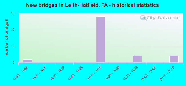
- New bridges - historical statistics
- 11930-1939
- 141970-1979
- 21990-1999
- 22010-2019


- Bridge Condition - Deck
- 25.0%Good
- 50.0%Satisfactory
- 25.0%Fair

- Bridge Condition - Superstructure
- 12.5%Very good
- 12.5%Good
- 25.0%Satisfactory
- 37.5%Fair
- 12.5%Poor

- Bridge Condition - Substructure
- 37.5%Good
- 37.5%Satisfactory
- 25.0%Fair

- Bridge Condition - Channel
- 50.0%Very good
- 25.0%Good
- 25.0%Fair
Find on map >> Show street view
Structure Number: 16563, Location: SOUTH UNION TOWNSHIP (Lat: 39.871894, Lng: -79.744469), Route carried "on" structure: Bypass US 40, Year Built: 1972, Status: Open, Structure Length: 6.61m (21.69ft), Average Daily Traffic: 5,100 (year 2021), Truck Traffic: 13%, Average Future Daily Traffic: 4,608 (year 2032), Design Load: HS 20+Mod, Features Intersected: SR 0043
Minimum Vertical Clearance: 30+ m (98+ ft), Kilometerpoint: 22.676, Lanes on structure: 2, Lanes under structure: 2, Base Highway Network: Yes, Owner: State Highway Agency, Approaching Roadway Width: 11.9m (39.0ft), Skew: 14 degrees, Material/Design: Prestressed concrete, Design/Construction: Stringer/Multi-beam, Number Of Spans In Main Unit: 3, Length of Maximum Span: 31.4m (103.0ft), Curb or Sidewalk Widths: Left: 0.3m (1.0ft), Right: 0.3m (1.0ft), Curb-To-Curb Width: 11.9m (39.0ft), Out-to-Out Width: 13.2m (43.3ft)
Condition: Deck: Satisfactory, Superstructure: Satisfactory, Substructure: Good, Operating Rating: 59.0 metric tons, Method Used To Determine Operating Rating: Load Factor (LF), Inventory Rating: 35.4 metric tons, Method Used To Determine Inventory Rating: Load Factor (LF), Structural Evaluation: Equal to present minimum criteria, Deck Geometry: Equal to present minimum criteria, Underclear: Better than present minimum criteria, Approach Roadway Alignment: Equal to present desirable criteria, Length Of Structure Improvement: 7.60m (24.93ft), Designated Inspection Frequency: Every 24 months, Inspection Date: November 2020, Deck Structure Type: Concrete Cast-file-Place, Wearing Surface/Protective System: Wearing Surface: Monolithic Concrete
Find on map >> Show street view
Structure Number: 16564, Location: SOUTH UNION TOWNSHIP (Lat: 39.871914, Lng: -79.744200), Route carried "on" structure: Bypass US 40, Year Built: 1972, Status: Open, Structure Length: 6.61m (21.69ft), Average Daily Traffic: 5,169 (year 2021), Truck Traffic: 13%, Average Future Daily Traffic: 4,183 (year 2032), Design Load: HS 20+Mod, Features Intersected: SR 0043
Minimum Vertical Clearance: 30+ m (98+ ft), Kilometerpoint: 22.610, Lanes on structure: 2, Lanes under structure: 2, Base Highway Network: Yes, Owner: State Highway Agency, Approaching Roadway Width: 11.9m (39.0ft), Skew: 14 degrees, Material/Design: Prestressed concrete, Design/Construction: Stringer/Multi-beam, Number Of Spans In Main Unit: 3, Length of Maximum Span: 31.4m (103.0ft), Curb or Sidewalk Widths: Left: 0.2m (0.7ft), Right: 0.2m (0.7ft), Curb-To-Curb Width: 11.9m (39.0ft), Out-to-Out Width: 13.2m (43.3ft)
Condition: Deck: Fair, Superstructure: Fair, Substructure: Satisfactory, Operating Rating: 64.4 metric tons, Method Used To Determine Operating Rating: Load Factor (LF), Inventory Rating: 27.2 metric tons, Method Used To Determine Inventory Rating: Load Factor (LF), Structural Evaluation: Somewhat better than minimum adequacy, Deck Geometry: Equal to present minimum criteria, Underclear: Equal to present minimum criteria, Approach Roadway Alignment: Equal to present desirable criteria, Length Of Structure Improvement: 7.60m (24.93ft), Designated Inspection Frequency: Every 24 months, Inspection Date: November 2020, Bridge Improvement Cost: $24,000, Roadway Improvement Cost: $70,000, Total Project Cost: $322,000, Deck Structure Type: Concrete Cast-file-Place, Wearing Surface/Protective System: Wearing Surface: Monolithic Concrete
Find on map >> Show street view
Structure Number: 16615, Location: SOUTH UNION TOWNSHIP (Lat: 39.870014, Lng: -79.742272), Route carried "on" structure: US 119, Year Built: 1972, Status: Open, Structure Length: 8.38m (27.49ft), Average Daily Traffic: 7,121 (year 2021), Truck Traffic: 4%, Average Future Daily Traffic: 4,635 (year 2032), Design Load: HS 20+Mod, Features Intersected: SR 0040
Minimum Vertical Clearance: 30+ m (98+ ft), Kilometerpoint: 24.654, Lanes on structure: 2, Lanes under structure: 4, Base Highway Network: Yes, Owner: State Highway Agency, Approaching Roadway Width: 13.4m (44.0ft), Skew: 2 degrees, Material/Design: Prestressed concrete, Design/Construction: Stringer/Multi-beam, Number Of Spans In Main Unit: 4, Length of Maximum Span: 29.0m (95.1ft), Curb or Sidewalk Widths: Left: 0.2m (0.7ft), Right: 0.2m (0.7ft), Curb-To-Curb Width: 13.4m (44.0ft), Out-to-Out Width: 14.6m (47.9ft)
Condition: Deck: Good, Superstructure: Good, Substructure: Good, Operating Rating: 62.6 metric tons, Method Used To Determine Operating Rating: Load Factor (LF), Inventory Rating: 37.2 metric tons, Method Used To Determine Inventory Rating: Load Factor (LF), Structural Evaluation: Better than present minimum criteria, Deck Geometry: Equal to present minimum criteria, Underclear: Better than present minimum criteria, Approach Roadway Alignment: Equal to present desirable criteria, Length Of Structure Improvement: 9.40m (30.84ft), Designated Inspection Frequency: Every 24 months, Inspection Date: December 2020, Deck Structure Type: Concrete Cast-file-Place, Wearing Surface/Protective System: Wearing Surface: Latex Concrete
Find on map >> Show street view
Structure Number: 16616, Location: SOUTH & NORTH UNION TWP. (Lat: 39.870417, Lng: -79.742253), Route carried "on" structure: Bypass US 119, Year Built: 1971, Status: Open, Structure Length: 5.03m (16.50ft), Average Daily Traffic: 9,863 (year 2022), Truck Traffic: 6%, Average Future Daily Traffic: 17,321 (year 2032), Design Load: HS 20, Features Intersected: SR 2040
Minimum Vertical Clearance: 30+ m (98+ ft), Kilometerpoint: 25.067, Lanes on structure: 2, Lanes under structure: 8, Base Highway Network: Yes, Owner: State Highway Agency, Approaching Roadway Width: 12.2m (40.0ft), Skew: 10 degrees, Material/Design: Prestressed concrete, Design/Construction: Box Beam or Girders - Single/Spread, Number Of Spans In Main Unit: 3, Length of Maximum Span: 22.3m (73.2ft), Curb or Sidewalk Widths: Left: 0.3m (1.0ft), Right: 0.3m (1.0ft), Curb-To-Curb Width: 12.2m (40.0ft), Out-to-Out Width: 13.1m (43.0ft)
Condition: Deck: Satisfactory, Superstructure: Fair, Substructure: Fair, Operating Rating: 66.2 metric tons, Method Used To Determine Operating Rating: Load Factor (LF), Inventory Rating: 39.9 metric tons, Method Used To Determine Inventory Rating: Load Factor (LF), Structural Evaluation: Somewhat better than minimum adequacy, Deck Geometry: Better than present minimum criteria, Underclear: Superior to present desirable criteria, Approach Roadway Alignment: Equal to present desirable criteria, Length Of Structure Improvement: 6.00m (19.69ft), Designated Inspection Frequency: Every 24 months, Inspection Date: December 2020, Bridge Improvement Cost: $18,000, Roadway Improvement Cost: $54,000, Total Project Cost: $248,000, Deck Structure Type: Concrete Cast-file-Place, Wearing Surface/Protective System: Wearing Surface: Bituminous
Find on map >> Show street view
Structure Number: 16903, Location: SOUTH UNION TOWNSHIP (Lat: 39.882222, Lng: -79.740000), Route carried "on" structure: State highway , Year Built: 1972, Status: Open, Structure Length: 9.27m (30.41ft), Average Daily Traffic: 8,416 (year 2020), Truck Traffic: 8%, Average Future Daily Traffic: 7,769 (year 2032), Design Load: HS 20+Mod, Features Intersected: SR 0040, Facility Carried by Structure: SR 3009
Minimum Vertical Clearance: 30+ m (98+ ft), Kilometerpoint: 24.391, Lanes on structure: 4, Lanes under structure: 8, Owner: State Highway Agency, Approaching Roadway Width: 21.9m (71.9ft), Skew: 3 degrees, Material/Design: Prestressed concrete, Design/Construction: Stringer/Multi-beam, Number Of Spans In Main Unit: 4, Length of Maximum Span: 29.9m (98.1ft), Curb-To-Curb Width: 21.3m (69.9ft), Out-to-Out Width: 23.8m (78.1ft)
Condition: Deck: Satisfactory, Superstructure: Fair, Substructure: Satisfactory, Operating Rating: 96.2 metric tons, Method Used To Determine Operating Rating: Load Factor (LF), Inventory Rating: 49.9 metric tons, Method Used To Determine Inventory Rating: Load Factor (LF), Structural Evaluation: Somewhat better than minimum adequacy, Deck Geometry: Superior to present desirable criteria, Underclear: Meets minimum limits, Approach Roadway Alignment: Equal to present desirable criteria, Length Of Structure Improvement: 10.10m (33.14ft), Designated Inspection Frequency: Every 24 months, Inspection Date: Febuary 2021, Bridge Improvement Cost: $330,000, Roadway Improvement Cost: $972,000, Total Project Cost: $4,455,000, Deck Structure Type: Concrete Cast-file-Place, Wearing Surface/Protective System: Wearing Surface: Latex Concrete
Find on map >> Show street view
Structure Number: 17134, Location: LEITH (Lat: 39.878717, Lng: -79.720269), Route carried "on" structure: City street T618, Year Built: 1930, Status: Posted for load, Structure Length: 1.28m (4.20ft), Average Daily Traffic: 350 (year 2006), Truck Traffic: 5%, Average Future Daily Traffic: 490 (year 2012), Design Load: H 10, Features Intersected: REDSTONE CREEK, Facility Carried by Structure: TOWNSHIP DRIVE
Minimum Vertical Clearance: 30+ m (98+ ft), Kilometerpoint: 0.000, Lanes on structure: 2, Owner: County Highway Agency, Approaching Roadway Width: 6.7m (22.0ft), Material/Design: Steel, Design/Construction: Stringer/Multi-beam, Number Of Spans In Main Unit: 1, Length of Maximum Span: 12.5m (41.0ft), Curb or Sidewalk Widths: Left: 0.2m (0.7ft), Right: 0.2m (0.7ft), Curb-To-Curb Width: 5.9m (19.4ft), Out-to-Out Width: 6.5m (21.3ft)
Condition: Deck: Fair, Superstructure: Poor, Substructure: Fair, Channel: Good, Operating Rating: 15.4 metric tons, Method Used To Determine Operating Rating: Load Factor (LF), Inventory Rating: 9.1 metric tons, Method Used To Determine Inventory Rating: Load Factor (LF), Structural Evaluation: High priority of corrective action, Deck Geometry: High priority of corrective action, Waterway Adequacy: Better than present minimum criteria, Approach Roadway Alignment: Equal to present minimum criteria, Bridge Posting: Required (Relationship of Operating Rating to Maximum Legal Load: > 39.9% below), Length Of Structure Improvement: 2.00m (6.56ft), Designated Inspection Frequency: Every 24 months, Other Special Inspection Frequency: Every 12 months, Inspection Date: September 2021, Other Special Inspection Date: September 2021, Bridge Improvement Cost: $8,000, Roadway Improvement Cost: $25,000, Total Project Cost: $113,000, Deck Structure Type: Concrete Cast-file-Place, Wearing Surface/Protective System: Wearing Surface: Bituminous
Find on map >> Show street view
Structure Number: 17135, Location: SOUTH OF HATFIELD (Lat: 39.874172, Lng: -79.721139), Route carried "on" structure: City street T620, Year Built: 1978, Status: Open, Structure Length: 0.76m (2.49ft), Average Daily Traffic: 1,100 (year 2004), Truck Traffic: 5%, Average Future Daily Traffic: 1,540 (year 2023), Design Load: HS 20+Mod, Features Intersected: REDSTONE CREEK
Minimum Vertical Clearance: 30+ m (98+ ft), Kilometerpoint: 0.000, Lanes on structure: 2, Owner: Town or Township Highway Agency, Approaching Roadway Width: 6.4m (21.0ft), Material/Design: Concrete, Design/Construction: Slab, Number Of Spans In Main Unit: 1, Length of Maximum Span: 7.3m (24.0ft), Curb or Sidewalk Widths: Left: 0.4m (1.3ft), Right: 0.4m (1.3ft), Curb-To-Curb Width: 8.5m (27.9ft), Out-to-Out Width: 9.6m (31.5ft)
Condition: Deck: Satisfactory, Superstructure: Satisfactory, Substructure: Satisfactory, Channel: Fair, Operating Rating: 60.8 metric tons, Method Used To Determine Operating Rating: Load Factor (LF), Inventory Rating: 36.3 metric tons, Method Used To Determine Inventory Rating: Load Factor (LF), Structural Evaluation: Equal to present minimum criteria, Deck Geometry: Somewhat better than minimum adequacy, Waterway Adequacy: Better than present minimum criteria, Approach Roadway Alignment: Equal to present desirable criteria, Length Of Structure Improvement: 1.50m (4.92ft), Designated Inspection Frequency: Every 24 months, Inspection Date: April 2020, Wearing Surface/Protective System: Wearing Surface: Bituminous
Find on map >> Show street view
Structure Number: 46413, Location: 1.2 mi N of SR 3027 (Lat: 39.877917, Lng: -79.720356), Route carried "on" structure: State highway , Year Built: 2010, Status: Open, Structure Length: 0.67m (2.20ft), Average Daily Traffic: 820 (year 2022), Truck Traffic: 8%, Average Future Daily Traffic: 2,531 (year 2032), Design Load: HL 93, Features Intersected: Redstone Creek, Facility Carried by Structure: SR 2025
Minimum Vertical Clearance: 30+ m (98+ ft), Kilometerpoint: 1.859, Lanes on structure: 2, Owner: State Highway Agency, Approaching Roadway Width: 7.9m (25.9ft), Skew: 1 degrees, Material/Design: Concrete, Design/Construction: Culvert, Number Of Spans In Main Unit: 1, Length of Maximum Span: 6.1m (20.0ft), Curb-To-Curb Width: 9.1m (29.9ft), Out-to-Out Width: 13.6m (44.6ft)
Condition: Channel: Very good, Culverts: Very good, Operating Rating: 68.0 metric tons, Method Used To Determine Operating Rating: Load and Resistance Factor (LRFR), Inventory Rating: 51.7 metric tons, Method Used To Determine Inventory Rating: Load and Resistance Factor (LRFR), Structural Evaluation: Equal to present desirable criteria, Deck Geometry: Equal to present minimum criteria, Waterway Adequacy: Equal to present desirable criteria, Approach Roadway Alignment: Equal to present desirable criteria, Designated Inspection Frequency: Every 48 months, Inspection Date: Febuary 2019
Find on map >> Show street view
Structure Number: 48174, Location: Leith/Behnd U-town H.S. (Lat: 39.892222, Lng: -79.720514), Route carried "on" structure: City street , Year Built: 2013, Status: Open, Structure Length: 0.98m (3.22ft), Average Daily Traffic: 1,200 (year 2017), Truck Traffic: 5%, Average Future Daily Traffic: 1,480 (year 2032), Design Load: HL 93, Features Intersected: Redstone Creek, Facility Carried by Structure: Grant Street T-477
Minimum Vertical Clearance: 30+ m (98+ ft), Kilometerpoint: 0.000, Lanes on structure: 2, Owner: County Highway Agency, Approaching Roadway Width: 10.1m (33.1ft), Material/Design: Prestressed concrete, Design/Construction: Box Beam or Girders - Single/Spread, Number Of Spans In Main Unit: 1, Length of Maximum Span: 9.8m (32.2ft), Curb or Sidewalk Widths: Left: 0.2m (0.7ft), Right: 0.2m (0.7ft), Curb-To-Curb Width: 10.9m (35.8ft), Out-to-Out Width: 11.9m (39.0ft)
Condition: Deck: Good, Superstructure: Very good, Substructure: Good, Channel: Very good, Operating Rating: 57.0 metric tons, Method Used To Determine Operating Rating: Assigned ratings based on Load and Resistance Factor Design (LRFD) reported by rating factor (RF) using HL93 loadings, Inventory Rating: 36.0 metric tons, Method Used To Determine Inventory Rating: Assigned ratings based on Load and Resistance Factor Design (LRFD) reported by rating factor (RF) using HL93 loadings, Structural Evaluation: Better than present minimum criteria, Deck Geometry: Equal to present minimum criteria, Waterway Adequacy: Equal to present minimum criteria, Approach Roadway Alignment: Meets minimum limits, Designated Inspection Frequency: Every 24 months, Inspection Date: September 2021, Deck Structure Type: Concrete Cast-file-Place, Wearing Surface/Protective System: Wearing Surface: Monolithic Concrete, Deck Protection: Epoxy Coated Reinforcing
Find on map >> Show street view
Structure Number: 16563, Location: SOUTH UNION TOWNSHIP (Lat: 39.871894, Lng: -79.744469), Route carried "under" structure: State highway 43, Year Built: 1972, Structure Length: 0. m, Average Daily Traffic: 5,977 (year 2020), Truck Traffic: 23%, Features Intersected: SR 0043, Facility Carried by Structure: SR 0040
Minimum Vertical Clearance: 5.18m (16.99ft), Kilometerpoint: 6.280, Lanes on structure: 2, Lanes under structure: 2, Material/Design: Prestressed concrete, Design/Construction: Stringer/Multi-beam, Length of Maximum Span: 31.4m (103.0ft)
Find on map >> Show street view
Structure Number: 16564, Location: SOUTH UNION TOWNSHIP (Lat: 39.871914, Lng: -79.744200), Route carried "under" structure: State highway 43, Year Built: 1972, Structure Length: 0. m, Average Daily Traffic: 5,977 (year 2020), Truck Traffic: 23%, Features Intersected: SR 0043, Facility Carried by Structure: SR 0040
Minimum Vertical Clearance: 5.18m (16.99ft), Kilometerpoint: 6.280, Lanes on structure: 2, Lanes under structure: 2, Material/Design: Prestressed concrete, Design/Construction: Stringer/Multi-beam, Length of Maximum Span: 31.4m (103.0ft)
Find on map >> Show street view
Structure Number: 16614, Location: GEORGES TOWNSHIP (Lat: 39.865358, Lng: -79.747847), Route carried "under" structure: State highway 43, Year Built: 1992, Structure Length: 0. m, Average Daily Traffic: 5,977 (year 2020), Truck Traffic: 23%, Features Intersected: SR 0043, Facility Carried by Structure: SR 0119
Minimum Vertical Clearance: 5.21m (17.09ft), Kilometerpoint: 5.411, Lanes on structure: 3, Lanes under structure: 4, Material/Design: Prestressed concrete continuous, Design/Construction: Stringer/Multi-beam, Length of Maximum Span: 30.8m (101.0ft)
Find on map >> Show street view
Structure Number: 16614, Location: GEORGES TOWNSHIP (Lat: 39.865358, Lng: -79.747847), Route carried "under" structure: State highway 43, Year Built: 1992, Structure Length: 0. m, Average Daily Traffic: 5,423 (year 2020), Truck Traffic: 25%, Features Intersected: SR 0043, Facility Carried by Structure: SR 0119
Minimum Vertical Clearance: 5.31m (17.42ft), Kilometerpoint: 5.383, Lanes on structure: 3, Lanes under structure: 4, Material/Design: Prestressed concrete continuous, Design/Construction: Stringer/Multi-beam, Length of Maximum Span: 30.8m (101.0ft)
Find on map >> Show street view
Structure Number: 16615, Location: SOUTH UNION TOWNSHIP (Lat: 39.870014, Lng: -79.742272), Route carried "under" structure: Bypass US 40, Year Built: 1972, Structure Length: 0. m, Average Daily Traffic: 5,100 (year 2021), Truck Traffic: 13%, Features Intersected: SR 0040, Facility Carried by Structure: SR 0119
Minimum Vertical Clearance: 5.72m (18.77ft), Kilometerpoint: 23.408, Lanes on structure: 2, Lanes under structure: 4, Material/Design: Prestressed concrete, Design/Construction: Stringer/Multi-beam, Length of Maximum Span: 29.0m (95.1ft)
Find on map >> Show street view
Structure Number: 16615, Location: SOUTH UNION TOWNSHIP (Lat: 39.870014, Lng: -79.742272), Route carried "under" structure: Bypass US 40, Year Built: 1972, Structure Length: 0. m, Average Daily Traffic: 5,169 (year 2021), Truck Traffic: 13%, Features Intersected: SR 0040, Facility Carried by Structure: SR 0119
Minimum Vertical Clearance: 5.16m (16.93ft), Kilometerpoint: 23.345, Lanes on structure: 2, Lanes under structure: 4, Material/Design: Prestressed concrete, Design/Construction: Stringer/Multi-beam, Length of Maximum Span: 29.0m (95.1ft)
Find on map >> Show street view
Structure Number: 16616, Location: SOUTH & NORTH UNION TWP. (Lat: 39.870417, Lng: -79.742253), Route carried "under" structure: US 40B, Year Built: 1971, Structure Length: 0. m, Average Daily Traffic: 7,188 (year 2021), Truck Traffic: 2%, Features Intersected: SR 2040, Facility Carried by Structure: SR 0119 NORTHBOUND
Minimum Vertical Clearance: 6.30m (20.67ft), Kilometerpoint: 0.000, Lanes on structure: 2, Lanes under structure: 4, Material/Design: Prestressed concrete, Design/Construction: Box Beam or Girders - Single/Spread, Length of Maximum Span: 22.3m (73.2ft)
Find on map >> Show street view
Structure Number: 16616, Location: SOUTH & NORTH UNION TWP. (Lat: 39.870417, Lng: -79.742253), Route carried "under" structure: US 40B, Year Built: 1971, Structure Length: 0. m, Average Daily Traffic: 6,537 (year 2021), Truck Traffic: 2%, Features Intersected: SR 2040, Facility Carried by Structure: SR 0119 NORTHBOUND
Minimum Vertical Clearance: 6.30m (20.67ft), Kilometerpoint: 0.000, Lanes on structure: 2, Lanes under structure: 4, Material/Design: Prestressed concrete, Design/Construction: Box Beam or Girders - Single/Spread, Length of Maximum Span: 22.3m (73.2ft)
Find on map >> Show street view
Structure Number: 16903, Location: SOUTH UNION TOWNSHIP (Lat: 39.882222, Lng: -79.740000), Route carried "under" structure: Bypass US 40, Year Built: 1972, Structure Length: 0. m, Average Daily Traffic: 13,508 (year 2021), Truck Traffic: 13%, Features Intersected: SR 0040, Facility Carried by Structure: SR 3009
Minimum Vertical Clearance: 6.99m (22.93ft), Kilometerpoint: 21.997, Lanes on structure: 4, Lanes under structure: 4, Material/Design: Prestressed concrete, Design/Construction: Stringer/Multi-beam, Length of Maximum Span: 29.9m (98.1ft)
Find on map >> Show street view
Structure Number: 16903, Location: SOUTH UNION TOWNSHIP (Lat: 39.882222, Lng: -79.740000), Route carried "under" structure: Bypass US 40, Year Built: 1972, Structure Length: 0. m, Average Daily Traffic: 12,823 (year 2021), Truck Traffic: 13%, Features Intersected: SR 0040, Facility Carried by Structure: SR 3009
Minimum Vertical Clearance: 5.13m (16.83ft), Kilometerpoint: 21.966, Lanes on structure: 4, Lanes under structure: 4, Material/Design: Prestressed concrete, Design/Construction: Stringer/Multi-beam, Length of Maximum Span: 29.9m (98.1ft)