Bridge Statistics for Leland, North Carolina (NC)
Condition, Traffic, Stress, Structural Evaluation, Project Costs
- National Bridge Inventory (NBI) Statistics
- 34Number of bridges
- 531ft / 162mTotal length
- 393,910Total average daily traffic
- 47,985Total average daily truck traffic
- National Bridge Inventory (NBI) Registered Bridges for Leland
- No street view available for this location
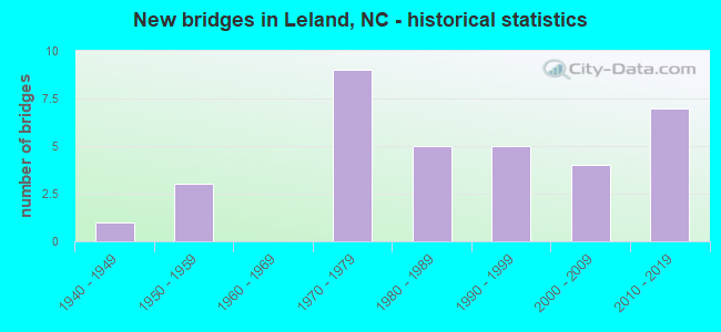
- New bridges - historical statistics
- 11940-1949
- 31950-1959
- 91970-1979
- 51980-1989
- 51990-1999
- 42000-2009
- 72010-2019
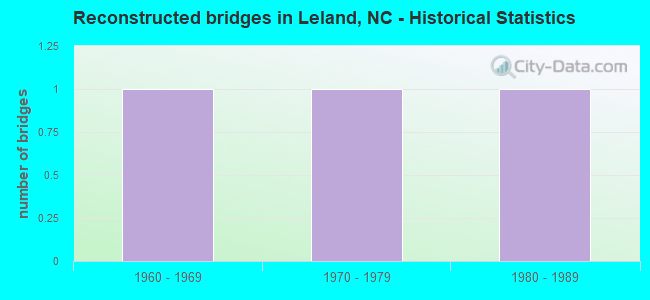
- Reconstructed bridges - Historical Statistics
- 11960-1969
- 11970-1979
- 11980-1989
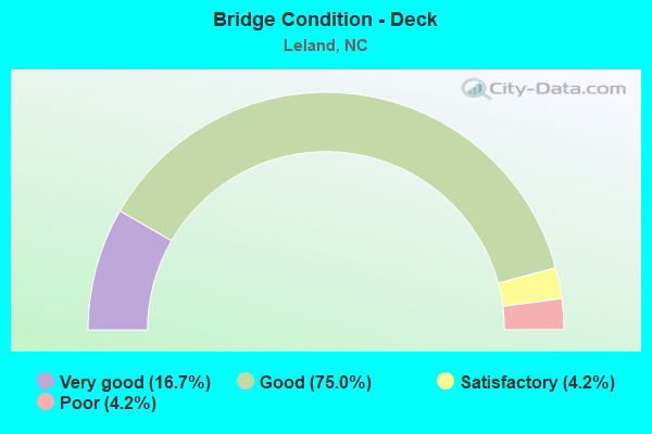
- Bridge Condition - Deck
- 16.7%Very good
- 75.0%Good
- 4.2%Satisfactory
- 4.2%Poor
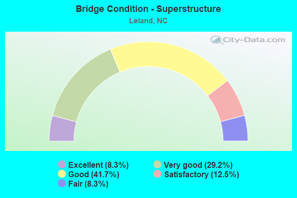
- Bridge Condition - Superstructure
- 8.3%Excellent
- 29.2%Very good
- 41.7%Good
- 12.5%Satisfactory
- 8.3%Fair
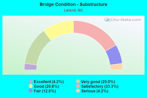
- Bridge Condition - Substructure
- 4.2%Excellent
- 25.0%Very good
- 20.8%Good
- 33.3%Satisfactory
- 12.5%Fair
- 4.2%Serious
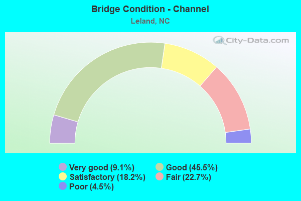
- Bridge Condition - Channel
- 9.1%Very good
- 45.5%Good
- 18.2%Satisfactory
- 22.7%Fair
- 4.5%Poor
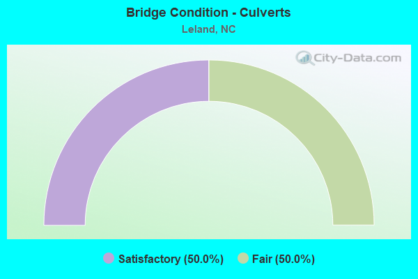
- Bridge Condition - Culverts
- 50.0%Satisfactory
- 50.0%Fair
Find on map >> Show street view
Structure Number: 190001, Location: 0.8 MI. N. JCT. SR1472 (Lat: 34.245842, Lng: -78.000639), Route carried "on" structure: State highway 1435, Year Built: 2004, Status: Open, Structure Length: 22.86m (75.00ft), Average Daily Traffic: 5,100 (year 2019), Truck Traffic: 7%, Average Future Daily Traffic: 10,200 (year 2040), Design Load: HS 20+Mod, Features Intersected: STURGEON CREEK
Minimum Vertical Clearance: 30+ m (98+ ft), Kilometerpoint: 0.000, Lanes on structure: 2, Owner: State Highway Agency, Approaching Roadway Width: 9.4m (30.8ft), Material/Design: Prestressed concrete continuous, Design/Construction: Stringer/Multi-beam, Number Of Spans In Main Unit: 7, Number Of Approach Spans: 2, Length of Maximum Span: 26.8m (87.9ft), Curb-To-Curb Width: 9.0m (29.5ft), Out-to-Out Width: 10.0m (32.8ft)
Condition: Deck: Good, Superstructure: Satisfactory, Substructure: Good, Channel: Good, Operating Rating: 78.9 metric tons, Method Used To Determine Operating Rating: Load Factor (LF), Inventory Rating: 35.3 metric tons, Method Used To Determine Inventory Rating: Load Factor (LF), Structural Evaluation: Equal to present minimum criteria, Deck Geometry: Meets minimum limits, Waterway Adequacy: Better than present minimum criteria, Approach Roadway Alignment: Equal to present desirable criteria, Designated Inspection Frequency: Every 24 months, Underwater Inspection Frequency: Every 60 months, Inspection Date: Febuary 2021, Underwater Inspection Date: April 2019, Deck Structure Type: Concrete Cast-file-Place, Wearing Surface/Protective System: Wearing Surface: Monolithic Concrete, Deck Protection: Epoxy Coated Reinforcing
Find on map >> Show street view
Structure Number: 190003, Location: 0.3 MI. N. JCT. SR1486 (Lat: 34.259167, Lng: -78.043944), Route carried "on" structure: State highway 1455, Year Built: 2013, Status: Open, Structure Length: 1.73m (5.68ft), Average Daily Traffic: 2,600 (year 2019), Truck Traffic: 7%, Average Future Daily Traffic: 5,200 (year 2040), Design Load: HL 93, Features Intersected: BANTON BRANCH
Minimum Vertical Clearance: 30+ m (98+ ft), Kilometerpoint: 0.000, Lanes on structure: 2, Owner: State Highway Agency, Approaching Roadway Width: 9.1m (29.9ft), Material/Design: Prestressed concrete, Design/Construction: Slab, Number Of Spans In Main Unit: 1, Length of Maximum Span: 16.7m (54.8ft), Curb-To-Curb Width: 9.1m (29.9ft), Out-to-Out Width: 10.0m (32.8ft)
Condition: Deck: Good, Superstructure: Very good, Substructure: Very good, Channel: Good, Operating Rating: 71.6 metric tons, Method Used To Determine Operating Rating: Load and Resistance Factor (LRFR), Inventory Rating: 45.3 metric tons, Method Used To Determine Inventory Rating: Load and Resistance Factor (LRFR), Structural Evaluation: Equal to present desirable criteria, Deck Geometry: Meets minimum limits, Waterway Adequacy: Better than present minimum criteria, Approach Roadway Alignment: Equal to present desirable criteria, Designated Inspection Frequency: Every 24 months, Underwater Inspection Frequency: Every 60 months, Inspection Date: April 2021, Underwater Inspection Date: April 2021, Deck Structure Type: Concrete Precast Panels, Wearing Surface/Protective System: Wearing Surface: Bituminous, Deck Protection: Epoxy Coated Reinforcing
Find on map >> Show street view
Structure Number: 19001, Location: 0.5 MI. W. JCT. SR1519 (Lat: 34.139047, Lng: -78.062303), Route carried "on" structure: State highway 1521, Year Built: 1994, Status: Open, Structure Length: 2.80m (9.19ft), Average Daily Traffic: 100 (year 2019), Truck Traffic: 6%, Average Future Daily Traffic: 200 (year 2040), Design Load: HS 20+Mod, Features Intersected: RICE CREEK
Minimum Vertical Clearance: 30+ m (98+ ft), Kilometerpoint: 0.000, Lanes on structure: 2, Owner: State Highway Agency, Approaching Roadway Width: 8.5m (27.9ft), Material/Design: Prestressed concrete, Design/Construction: Slab, Number Of Spans In Main Unit: 2, Length of Maximum Span: 13.4m (44.0ft), Curb-To-Curb Width: 7.3m (24.0ft), Out-to-Out Width: 8.2m (26.9ft)
Condition: Deck: Good, Superstructure: Good, Substructure: Good, Channel: Good, Operating Rating: 89.8 metric tons, Method Used To Determine Operating Rating: Load Factor (LF), Inventory Rating: 57.1 metric tons, Method Used To Determine Inventory Rating: Load Factor (LF), Structural Evaluation: Better than present minimum criteria, Deck Geometry: Equal to present minimum criteria, Waterway Adequacy: Better than present minimum criteria, Approach Roadway Alignment: Equal to present desirable criteria, Designated Inspection Frequency: Every 24 months, Underwater Inspection Frequency: Every 60 months, Inspection Date: May 2021, Underwater Inspection Date: December 2019, Deck Structure Type: Concrete Precast Panels, Wearing Surface/Protective System: Wearing Surface: Bituminous
Find on map >> Show street view
Structure Number: 190018, Location: 0.2 MI.N.JCT SR1472 (Lat: 34.256664, Lng: -78.057306), Route carried "on" structure: State highway 1426, Year Built: 1973, Status: Open, Structure Length: 7.37m (24.18ft), Average Daily Traffic: 10,500 (year 2019), Truck Traffic: 6%, Average Future Daily Traffic: 21,000 (year 2040), Design Load: HS 20+Mod, Features Intersected: US74/US76
Minimum Vertical Clearance: 30+ m (98+ ft), Kilometerpoint: 0.000, Lanes on structure: 2, Lanes under structure: 4, Owner: State Highway Agency, Approaching Roadway Width: 13.4m (44.0ft), Material/Design: Steel, Design/Construction: Stringer/Multi-beam, Number Of Spans In Main Unit: 2, Length of Maximum Span: 36.5m (119.8ft), Curb-To-Curb Width: 16.5m (54.1ft), Out-to-Out Width: 17.8m (58.4ft)
Condition: Deck: Good, Superstructure: Good, Substructure: Satisfactory, Operating Rating: 89.8 metric tons, Method Used To Determine Operating Rating: Load Factor (LF), Inventory Rating: 54.4 metric tons, Method Used To Determine Inventory Rating: Load Factor (LF), Structural Evaluation: Equal to present minimum criteria, Deck Geometry: Superior to present desirable criteria, Underclear: Somewhat better than minimum adequacy, Approach Roadway Alignment: Equal to present desirable criteria, Designated Inspection Frequency: Every 24 months, Inspection Date: April 2021, Deck Structure Type: Concrete Cast-file-Place, Wearing Surface/Protective System: Wearing Surface: Epoxy Overlay, Membrane: Epoxy
Find on map >> Show street view
Structure Number: 190029, Location: 1.7MI.E.JCT.SR1417 (Lat: 34.254878, Lng: -78.052272), Route carried "on" structure: US 74, Year Built: 1973, Status: Open, Structure Length: 8.59m (28.18ft), Average Daily Traffic: 15,000 (year 2018), Truck Traffic: 12%, Average Future Daily Traffic: 30,000 (year 2040), Design Load: HS 20+Mod, Features Intersected: SR1472,CSXRR
Minimum Vertical Clearance: 30+ m (98+ ft), Kilometerpoint: 0.000, Lanes on structure: 3, Lanes under structure: 2, Base Highway Network: Yes (Inventory Route: 2, Subroute: 74), Owner: State Highway Agency, Approaching Roadway Width: 17.0m (55.8ft), Skew: 14 degrees, Material/Design: Steel, Design/Construction: Stringer/Multi-beam, Number Of Spans In Main Unit: 4, Length of Maximum Span: 30.7m (100.7ft), Curb-To-Curb Width: 16.5m (54.1ft), Out-to-Out Width: 17.1m (56.1ft)
Condition: Deck: Good, Superstructure: Good, Substructure: Good, Operating Rating: 76.2 metric tons, Method Used To Determine Operating Rating: Load Factor (LF), Inventory Rating: 45.3 metric tons, Method Used To Determine Inventory Rating: Load Factor (LF), Structural Evaluation: Better than present minimum criteria, Deck Geometry: Equal to present minimum criteria, Underclear: Meets minimum limits, Approach Roadway Alignment: Equal to present desirable criteria, Designated Inspection Frequency: Every 24 months, Inspection Date: March 2021, Deck Structure Type: Concrete Cast-file-Place, Wearing Surface/Protective System: Wearing Surface: Epoxy Overlay, Membrane: Epoxy
Find on map >> Show street view
Structure Number: 19003, Location: 1.0 MI.S.JCT. SR1413 (Lat: 34.165667, Lng: -78.126989), Route carried "on" structure: State highway 1411, Year Built: 1990, Status: Open, Structure Length: 2.43m (7.97ft), Average Daily Traffic: 250 (year 2000), Truck Traffic: 6%, Average Future Daily Traffic: 500 (year 2040), Design Load: HS 20+Mod, Features Intersected: TOWN CREEK
Minimum Vertical Clearance: 30+ m (98+ ft), Kilometerpoint: 0.000, Lanes on structure: 2, Owner: State Highway Agency, Approaching Roadway Width: 7.3m (24.0ft), Material/Design: Prestressed concrete, Design/Construction: Slab, Number Of Spans In Main Unit: 2, Length of Maximum Span: 11.2m (36.7ft), Curb-To-Curb Width: 7.2m (23.6ft), Out-to-Out Width: 8.2m (26.9ft)
Condition: Deck: Good, Superstructure: Good, Substructure: Satisfactory, Channel: Satisfactory, Operating Rating: 71.6 metric tons, Method Used To Determine Operating Rating: Load Factor (LF), Inventory Rating: 42.6 metric tons, Method Used To Determine Inventory Rating: Load Factor (LF), Structural Evaluation: Equal to present minimum criteria, Deck Geometry: Meets minimum limits, Waterway Adequacy: Better than present minimum criteria, Approach Roadway Alignment: Equal to present desirable criteria, Designated Inspection Frequency: Every 24 months, Underwater Inspection Frequency: Every 60 months, Inspection Date: May 2021, Underwater Inspection Date: July 2019, Wearing Surface/Protective System: Wearing Surface: Bituminous
Find on map >> Show street view
Structure Number: 190031, Location: 0.2 MI. N JCT SR1410 (Lat: 34.163167, Lng: -78.128139), Route carried "on" structure: State highway 1411, Year Built: 1990, Status: Open, Structure Length: 3.41m (11.19ft), Average Daily Traffic: 250 (year 2000), Truck Traffic: 6%, Average Future Daily Traffic: 500 (year 2040), Design Load: HS 20+Mod, Features Intersected: TOWN CREEK
Minimum Vertical Clearance: 30+ m (98+ ft), Kilometerpoint: 0.000, Lanes on structure: 2, Owner: State Highway Agency, Approaching Roadway Width: 7.3m (24.0ft), Skew: 1 degrees, Material/Design: Prestressed concrete, Design/Construction: Stringer/Multi-beam, Number Of Spans In Main Unit: 3, Length of Maximum Span: 10.9m (35.8ft), Curb-To-Curb Width: 7.3m (24.0ft), Out-to-Out Width: 8.2m (26.9ft)
Condition: Deck: Good, Superstructure: Very good, Substructure: Good, Channel: Satisfactory, Operating Rating: 89.8 metric tons, Method Used To Determine Operating Rating: Load Factor (LF), Inventory Rating: 60.7 metric tons, Method Used To Determine Inventory Rating: Load Factor (LF), Structural Evaluation: Better than present minimum criteria, Deck Geometry: Somewhat better than minimum adequacy, Waterway Adequacy: Better than present minimum criteria, Approach Roadway Alignment: Equal to present minimum criteria, Designated Inspection Frequency: Every 24 months, Underwater Inspection Frequency: Every 60 months, Inspection Date: May 2021, Underwater Inspection Date: November 2019, Deck Structure Type: Concrete Cast-file-Place, Wearing Surface/Protective System: Wearing Surface: Monolithic Concrete
Find on map >> Show street view
Structure Number: 190032, Location: 0.2 MI.W.JCT.SR1408 (Lat: 34.146942, Lng: -78.115486), Route carried "on" structure: State highway 1410, Year Built: 1983, Status: Open, Structure Length: 1.28m (4.20ft), Average Daily Traffic: 460 (year 2000), Truck Traffic: 6%, Average Future Daily Traffic: 920 (year 2040), Design Load: HS 20+Mod, Features Intersected: RUSSELLS CREEK
Minimum Vertical Clearance: 30+ m (98+ ft), Kilometerpoint: 0.000, Lanes on structure: 2, Owner: State Highway Agency, Approaching Roadway Width: 5.7m (18.7ft), Material/Design: Steel, Design/Construction: Culvert, Number Of Spans In Main Unit: 4, Length of Maximum Span: 2.4m (7.9ft)
Condition: Channel: Good, Culverts: Satisfactory, Operating Rating: 89.8 metric tons, Method Used To Determine Operating Rating: Load and Resistance Factor (LRFR), Inventory Rating: 89.8 metric tons, Method Used To Determine Inventory Rating: Load and Resistance Factor (LRFR), Structural Evaluation: Equal to present minimum criteria, Waterway Adequacy: Better than present minimum criteria, Approach Roadway Alignment: Equal to present desirable criteria, Designated Inspection Frequency: Every 24 months, Underwater Inspection Frequency: Every 60 months, Inspection Date: December 2020, Underwater Inspection Date: December 2020
Find on map >> Show street view
Structure Number: 190033, Location: 2.3 MI W JCT SR1411 (Lat: 34.176517, Lng: -78.145244), Route carried "on" structure: State highway 1413, Year Built: 1980, Status: Open, Structure Length: 2.80m (9.19ft), Average Daily Traffic: 1,400 (year 2019), Truck Traffic: 6%, Average Future Daily Traffic: 2,800 (year 2040), Design Load: HS 20+Mod, Features Intersected: BRANCH OF TOWN CREEK
Minimum Vertical Clearance: 30+ m (98+ ft), Kilometerpoint: 0.000, Lanes on structure: 2, Owner: State Highway Agency, Approaching Roadway Width: 5.7m (18.7ft), Material/Design: Prestressed concrete, Design/Construction: Slab, Number Of Spans In Main Unit: 3, Length of Maximum Span: 8.8m (28.9ft), Curb-To-Curb Width: 10.9m (35.8ft), Out-to-Out Width: 11.7m (38.4ft)
Condition: Deck: Good, Superstructure: Good, Substructure: Satisfactory, Channel: Good, Operating Rating: 89.8 metric tons, Method Used To Determine Operating Rating: Load Factor (LF), Inventory Rating: 58.0 metric tons, Method Used To Determine Inventory Rating: Load Factor (LF), Structural Evaluation: Equal to present minimum criteria, Deck Geometry: Equal to present minimum criteria, Waterway Adequacy: Better than present minimum criteria, Approach Roadway Alignment: Equal to present desirable criteria, Designated Inspection Frequency: Every 24 months, Underwater Inspection Frequency: Every 60 months, Inspection Date: May 2021, Underwater Inspection Date: January 2020, Deck Structure Type: Concrete Precast Panels, Wearing Surface/Protective System: Wearing Surface: Bituminous
Find on map >> Show street view
Structure Number: 190036, Location: 1.7 MI.E JCT SR1417 (Lat: 34.254956, Lng: -78.051856), Route carried "on" structure: US 74, Year Built: 1973, Status: Open, Structure Length: 8.74m (28.67ft), Average Daily Traffic: 14,000 (year 2019), Truck Traffic: 12%, Average Future Daily Traffic: 28,000 (year 2040), Design Load: HS 20+Mod, Features Intersected: SR1472,SCSX RR
Minimum Vertical Clearance: 30+ m (98+ ft), Kilometerpoint: 0.000, Lanes on structure: 3, Lanes under structure: 2, Base Highway Network: Yes (Inventory Route: 2, Subroute: 74), Owner: State Highway Agency, Approaching Roadway Width: 14.6m (47.9ft), Skew: 14 degrees, Material/Design: Steel, Design/Construction: Stringer/Multi-beam, Number Of Spans In Main Unit: 4, Number Of Approach Spans: 2, Length of Maximum Span: 30.1m (98.8ft), Curb-To-Curb Width: 14.6m (47.9ft), Out-to-Out Width: 15.2m (49.9ft)
Condition: Deck: Good, Superstructure: Good, Substructure: Good, Operating Rating: 82.5 metric tons, Method Used To Determine Operating Rating: Load Factor (LF), Inventory Rating: 48.9 metric tons, Method Used To Determine Inventory Rating: Load Factor (LF), Structural Evaluation: Better than present minimum criteria, Deck Geometry: Meets minimum limits, Underclear: Equal to present minimum criteria, Approach Roadway Alignment: Equal to present desirable criteria, Designated Inspection Frequency: Every 24 months, Inspection Date: March 2021, Deck Structure Type: Concrete Cast-file-Place, Wearing Surface/Protective System: Wearing Surface: Monolithic Concrete
Find on map >> Show street view
Structure Number: 190039, Location: 1.6 MI.W. OF JCT.US17 (Lat: 34.241153, Lng: -78.033489), Route carried "on" structure: US 74, Year Built: 1974, Status: Open, Structure Length: 0.67m (2.20ft), Average Daily Traffic: 27,500 (year 2019), Truck Traffic: 12%, Average Future Daily Traffic: 55,000 (year 2040), Design Load: HS 20+Mod, Features Intersected: STURGEON CREEK
Minimum Vertical Clearance: 30+ m (98+ ft), Kilometerpoint: 0.000, Lanes on structure: 4, Base Highway Network: Yes (Inventory Route: 2, Subroute: 74), Owner: State Highway Agency, Approaching Roadway Width: 22.8m (74.8ft), Skew: 22 degrees, Material/Design: Concrete continuous, Design/Construction: Culvert, Number Of Spans In Main Unit: 2, Length of Maximum Span: 2.7m (8.9ft)
Condition: Channel: Fair, Culverts: Fair, Operating Rating: 47.1 metric tons, Method Used To Determine Operating Rating: Load and Resistance Factor (LRFR), Inventory Rating: 36.2 metric tons, Method Used To Determine Inventory Rating: Load and Resistance Factor (LRFR), Structural Evaluation: Somewhat better than minimum adequacy, Waterway Adequacy: Better than present minimum criteria, Approach Roadway Alignment: Equal to present desirable criteria, Designated Inspection Frequency: Every 24 months, Underwater Inspection Frequency: Every 60 months, Inspection Date: December 2021, Underwater Inspection Date: December 2021
Find on map >> Show street view
Structure Number: 190054, Location: 1.6 MI.N.OF JCT SR1416 (Lat: 34.232500, Lng: -78.122639), Route carried "on" structure: State highway 87, Year Built: 2014, Status: Open, Structure Length: 2.34m (7.68ft), Average Daily Traffic: 3,800 (year 2019), Truck Traffic: 7%, Average Future Daily Traffic: 7,600 (year 2040), Design Load: HL 93, Features Intersected: HOOD CREEK
Minimum Vertical Clearance: 30+ m (98+ ft), Kilometerpoint: 0.000, Lanes on structure: 2, Owner: State Highway Agency, Approaching Roadway Width: 9.1m (29.9ft), Material/Design: Prestressed concrete, Design/Construction: Slab, Number Of Spans In Main Unit: 1, Length of Maximum Span: 22.5m (73.8ft), Curb-To-Curb Width: 9.2m (30.2ft), Out-to-Out Width: 10.1m (33.1ft)
Condition: Deck: Very good, Superstructure: Very good, Substructure: Very good, Channel: Good, Operating Rating: 63.5 metric tons, Method Used To Determine Operating Rating: Load and Resistance Factor (LRFR), Inventory Rating: 48.0 metric tons, Method Used To Determine Inventory Rating: Load and Resistance Factor (LRFR), Structural Evaluation: Equal to present desirable criteria, Deck Geometry: Meets minimum limits, Waterway Adequacy: Better than present minimum criteria, Approach Roadway Alignment: Equal to present minimum criteria, Designated Inspection Frequency: Every 24 months, Inspection Date: Febuary 2021, Deck Structure Type: Concrete Precast Panels, Wearing Surface/Protective System: Wearing Surface: Bituminous, Deck Protection: Epoxy Coated Reinforcing
Find on map >> Show street view
Structure Number: 190061, Location: 0.5 MI. N. JCT. SR1518 (Lat: 34.136572, Lng: -77.987358), Route carried "on" structure: State highway 133, Year Built: 2005, Status: Open, Structure Length: 9.20m (30.18ft), Average Daily Traffic: 7,000 (year 2019), Truck Traffic: 8%, Average Future Daily Traffic: 14,000 (year 2040), Design Load: HS 20+Mod, Features Intersected: TOWN CREEK
Minimum Vertical Clearance: 30+ m (98+ ft), Kilometerpoint: 0.000, Lanes on structure: 2, Base Highway Network: Yes, Owner: State Highway Agency, Approaching Roadway Width: 8.5m (27.9ft), Skew: 3 degrees, Material/Design: Prestressed concrete, Design/Construction: Slab, Number Of Spans In Main Unit: 5, Length of Maximum Span: 17.6m (57.7ft), Curb-To-Curb Width: 10.0m (32.8ft), Out-to-Out Width: 10.9m (35.8ft)
Condition: Deck: Good, Superstructure: Good, Substructure: Satisfactory, Channel: Good, Operating Rating: 77.1 metric tons, Method Used To Determine Operating Rating: Load Factor (LF), Inventory Rating: 46.2 metric tons, Method Used To Determine Inventory Rating: Load Factor (LF), Structural Evaluation: Equal to present minimum criteria, Deck Geometry: Meets minimum limits, Waterway Adequacy: Better than present minimum criteria, Approach Roadway Alignment: Equal to present desirable criteria, Designated Inspection Frequency: Every 24 months, Underwater Inspection Frequency: Every 60 months, Inspection Date: May 2021, Underwater Inspection Date: January 2021, Deck Structure Type: Concrete Precast Panels, Wearing Surface/Protective System: Wearing Surface: Bituminous, Deck Protection: Epoxy Coated Reinforcing
Find on map >> Show street view
Structure Number: 190066, Location: 0.1 MI N JCT NC87 (Lat: 34.134667, Lng: -78.094919), Route carried "on" structure: US 17, Year Built: 1980, Status: Open, Structure Length: 0.64m (2.10ft), Average Daily Traffic: 38,000 (year 2019), Truck Traffic: 14%, Average Future Daily Traffic: 76,000 (year 2040), Design Load: HS 20+Mod, Features Intersected: BELL SWAMP
Minimum Vertical Clearance: 30+ m (98+ ft), Kilometerpoint: 10.820, Lanes on structure: 4, Base Highway Network: Yes (Inventory Route: 2, Subroute: 17), Owner: State Highway Agency, Approaching Roadway Width: 24.0m (78.7ft), Skew: 1 degrees, Material/Design: Concrete continuous, Design/Construction: Culvert, Number Of Spans In Main Unit: 2, Length of Maximum Span: 3.6m (11.8ft)
Condition: Channel: Fair, Culverts: Fair, Operating Rating: 50.8 metric tons, Method Used To Determine Operating Rating: Load and Resistance Factor (LRFR), Inventory Rating: 39.0 metric tons, Method Used To Determine Inventory Rating: Load and Resistance Factor (LRFR), Structural Evaluation: Somewhat better than minimum adequacy, Waterway Adequacy: Better than present minimum criteria, Approach Roadway Alignment: Equal to present desirable criteria, Designated Inspection Frequency: Every 24 months, Underwater Inspection Frequency: Every 60 months, Inspection Date: May 2021, Underwater Inspection Date: May 2021
Find on map >> Show street view
Structure Number: 190067, Location: 4 MI S. JCT. US17 (Lat: 34.172600, Lng: -77.990275), Route carried "on" structure: State highway 133, Year Built: 1991, Status: Open, Structure Length: 2.49m (8.17ft), Average Daily Traffic: 7,600 (year 2019), Truck Traffic: 6%, Average Future Daily Traffic: 15,200 (year 2040), Design Load: HS 20+Mod, Features Intersected: MALLORY CREEK
Minimum Vertical Clearance: 30+ m (98+ ft), Kilometerpoint: 0.000, Lanes on structure: 2, Base Highway Network: Yes, Owner: State Highway Agency, Approaching Roadway Width: 8.2m (26.9ft), Skew: 1 degrees, Material/Design: Prestressed concrete, Design/Construction: Slab, Number Of Spans In Main Unit: 2, Length of Maximum Span: 11.8m (38.7ft), Curb-To-Curb Width: 9.9m (32.5ft), Out-to-Out Width: 10.9m (35.8ft)
Condition: Deck: Good, Superstructure: Good, Substructure: Fair, Channel: Fair, Operating Rating: 89.8 metric tons, Method Used To Determine Operating Rating: Load Factor (LF), Inventory Rating: 58.0 metric tons, Method Used To Determine Inventory Rating: Load Factor (LF), Structural Evaluation: Somewhat better than minimum adequacy, Deck Geometry: Meets minimum limits, Waterway Adequacy: Better than present minimum criteria, Approach Roadway Alignment: Equal to present desirable criteria, Designated Inspection Frequency: Every 24 months, Underwater Inspection Frequency: Every 60 months, Inspection Date: May 2021, Underwater Inspection Date: June 2020, Deck Structure Type: Concrete Precast Panels, Wearing Surface/Protective System: Wearing Surface: Bituminous
Find on map >> Show street view
Structure Number: 190073, Location: 0.5 MI. N. OF JCT. SR1406 (Lat: 34.156544, Lng: -78.091894), Route carried "on" structure: US 17, Year Built: 1979, Status: Open, Structure Length: 5.97m (19.59ft), Average Daily Traffic: 17,500 (year 2019), Truck Traffic: 14%, Average Future Daily Traffic: 35,000 (year 2040), Design Load: HS 20+Mod, Features Intersected: TOWN CREEK
Minimum Vertical Clearance: 30+ m (98+ ft), Kilometerpoint: 0.000, Lanes on structure: 2, Base Highway Network: Yes (Inventory Route: 2, Subroute: 17), Owner: State Highway Agency, Approaching Roadway Width: 12.1m (39.7ft), Skew: 10 degrees, Material/Design: Prestressed concrete, Design/Construction: Stringer/Multi-beam, Number Of Spans In Main Unit: 3, Length of Maximum Span: 19.2m (63.0ft), Curb-To-Curb Width: 12.1m (39.7ft), Out-to-Out Width: 13.1m (43.0ft)
Condition: Deck: Good, Superstructure: Very good, Substructure: Satisfactory, Channel: Good, Operating Rating: 89.8 metric tons, Method Used To Determine Operating Rating: Load Factor (LF), Inventory Rating: 45.3 metric tons, Method Used To Determine Inventory Rating: Load Factor (LF), Structural Evaluation: Equal to present minimum criteria, Deck Geometry: Better than present minimum criteria, Waterway Adequacy: Equal to present minimum criteria, Approach Roadway Alignment: Equal to present desirable criteria, Designated Inspection Frequency: Every 24 months, Underwater Inspection Frequency: Every 60 months, Inspection Date: May 2021, Underwater Inspection Date: January 2019, Deck Structure Type: Concrete Cast-file-Place, Wearing Surface/Protective System: Wearing Surface: Monolithic Concrete
Find on map >> Show street view
Structure Number: 190074, Location: 0.5 MI N. OF JCT SR1406 (Lat: 34.156644, Lng: -78.092153), Route carried "on" structure: US 17, Year Built: 1950, Year Reconstructed: 1979, Status: Open, Structure Length: 4.32m (14.17ft), Average Daily Traffic: 15,000 (year 2019), Truck Traffic: 14%, Average Future Daily Traffic: 35,000 (year 2040), Design Load: HS 20, Features Intersected: TOWN CREEK
Minimum Vertical Clearance: 30+ m (98+ ft), Kilometerpoint: 11.277, Lanes on structure: 2, Base Highway Network: Yes (Inventory Route: 2, Subroute: 17), Owner: State Highway Agency, Approaching Roadway Width: 12.1m (39.7ft), Skew: 10 degrees, Material/Design: Concrete, Design/Construction: Tee Beam, Number Of Spans In Main Unit: 4, Length of Maximum Span: 10.3m (33.8ft), Curb-To-Curb Width: 12.2m (40.0ft), Out-to-Out Width: 13.2m (43.3ft)
Condition: Deck: Good, Superstructure: Good, Substructure: Fair, Channel: Good, Operating Rating: 44.4 metric tons, Method Used To Determine Operating Rating: Load Factor (LF), Inventory Rating: 26.3 metric tons, Method Used To Determine Inventory Rating: Load Factor (LF), Structural Evaluation: Somewhat better than minimum adequacy, Deck Geometry: Better than present minimum criteria, Waterway Adequacy: Equal to present minimum criteria, Approach Roadway Alignment: Equal to present desirable criteria, Designated Inspection Frequency: Every 24 months, Underwater Inspection Frequency: Every 60 months, Inspection Date: May 2021, Underwater Inspection Date: January 2019, Deck Structure Type: Concrete Cast-file-Place, Wearing Surface/Protective System: Wearing Surface: Bituminous
Find on map >> Show street view
Structure Number: 190075, Location: 2.6 MI.S.JCT.US17/74/76 (Lat: 34.199339, Lng: -77.980631), Route carried "on" structure: State highway 133, Year Built: 1991, Status: Open, Structure Length: 2.80m (9.19ft), Average Daily Traffic: 14,000 (year 2018), Truck Traffic: 12%, Average Future Daily Traffic: 28,000 (year 2040), Design Load: HS 20+Mod, Features Intersected: JACKEYS CREEK
Minimum Vertical Clearance: 30+ m (98+ ft), Kilometerpoint: 0.000, Lanes on structure: 2, Base Highway Network: Yes (Inventory Route: 3, Subroute: 33), Owner: State Highway Agency, Approaching Roadway Width: 9.7m (31.8ft), Material/Design: Prestressed concrete, Design/Construction: Slab, Number Of Spans In Main Unit: 3, Length of Maximum Span: 8.8m (28.9ft), Curb-To-Curb Width: 9.8m (32.2ft), Out-to-Out Width: 10.9m (35.8ft)
Condition: Deck: Good, Superstructure: Good, Substructure: Satisfactory, Channel: Fair, Operating Rating: 89.8 metric tons, Method Used To Determine Operating Rating: Load Factor (LF), Inventory Rating: 73.4 metric tons, Method Used To Determine Inventory Rating: Load Factor (LF), Structural Evaluation: Equal to present minimum criteria, Deck Geometry: Meets minimum limits, Waterway Adequacy: Better than present minimum criteria, Approach Roadway Alignment: Equal to present minimum criteria, Designated Inspection Frequency: Every 24 months, Underwater Inspection Frequency: Every 60 months, Inspection Date: May 2021, Underwater Inspection Date: Febuary 2019, Deck Structure Type: Concrete Precast Panels, Wearing Surface/Protective System: Wearing Surface: Bituminous
Find on map >> Show street view
Structure Number: 190078, Location: 2.2 MI N JCT NC87 (Lat: 34.158622, Lng: -78.091311), Route carried "on" structure: US 17, Year Built: 1950, Year Reconstructed: 1980, Status: Open, Structure Length: 0.70m (2.30ft), Average Daily Traffic: 35,000 (year 2019), Truck Traffic: 14%, Average Future Daily Traffic: 70,000 (year 2040), Design Load: HS 20, Features Intersected: TOWN CREEK OVERFLOW
Minimum Vertical Clearance: 30+ m (98+ ft), Kilometerpoint: 0.000, Lanes on structure: 5, Base Highway Network: Yes (Inventory Route: 2, Subroute: 17), Owner: State Highway Agency, Approaching Roadway Width: 21.6m (70.9ft), Skew: 1 degrees, Material/Design: Concrete continuous, Design/Construction: Culvert, Number Of Spans In Main Unit: 2, Length of Maximum Span: 3.0m (9.8ft)
Condition: Channel: Poor, Culverts: Fair, Operating Rating: 68.9 metric tons, Method Used To Determine Operating Rating: Load and Resistance Factor (LRFR), Inventory Rating: 52.6 metric tons, Method Used To Determine Inventory Rating: Load and Resistance Factor (LRFR), Structural Evaluation: Somewhat better than minimum adequacy, Waterway Adequacy: Better than present minimum criteria, Approach Roadway Alignment: Equal to present desirable criteria, Designated Inspection Frequency: Every 24 months, Underwater Inspection Frequency: Every 60 months, Inspection Date: September 2021, Underwater Inspection Date: September 2021
Find on map >> Show street view
Structure Number: 190083, Location: 0.7 MI. N. JCT. SR1414 (Lat: 34.199389, Lng: -78.056603), Route carried "on" structure: US 17, Year Built: 1980, Status: Open, Structure Length: 3.38m (11.09ft), Average Daily Traffic: 14,750 (year 2019), Truck Traffic: 12%, Average Future Daily Traffic: 29,500 (year 2040), Design Load: HS 20+Mod, Features Intersected: USTC RAILROAD
Minimum Vertical Clearance: 30+ m (98+ ft), Kilometerpoint: 0.000, Lanes on structure: 2, Base Highway Network: Yes (Inventory Route: 2, Subroute: 17), Owner: State Highway Agency, Approaching Roadway Width: 9.4m (30.8ft), Skew: 10 degrees, Material/Design: Steel, Design/Construction: Stringer/Multi-beam, Number Of Spans In Main Unit: 3, Number Of Approach Spans: 2, Length of Maximum Span: 10.9m (35.8ft), Curb-To-Curb Width: 12.4m (40.7ft), Out-to-Out Width: 13.0m (42.7ft)
Condition: Deck: Good, Superstructure: Satisfactory, Substructure: Satisfactory, Operating Rating: 89.8 metric tons, Method Used To Determine Operating Rating: Load Factor (LF), Inventory Rating: 62.5 metric tons, Method Used To Determine Inventory Rating: Load Factor (LF), Structural Evaluation: Equal to present minimum criteria, Deck Geometry: Better than present minimum criteria, Underclear: Equal to present minimum criteria, Approach Roadway Alignment: Equal to present desirable criteria, Designated Inspection Frequency: Every 24 months, Inspection Date: April 2021, Deck Structure Type: Concrete Cast-file-Place, Wearing Surface/Protective System: Wearing Surface: Monolithic Concrete
Find on map >> Show street view
Structure Number: 190084, Location: 0.7MI.N.JCT.SR1414 (Lat: 34.199575, Lng: -78.056742), Route carried "on" structure: US 17, Year Built: 1980, Status: Open, Structure Length: 3.38m (11.09ft), Average Daily Traffic: 14,750 (year 2019), Truck Traffic: 12%, Average Future Daily Traffic: 29,500 (year 2040), Design Load: HS 20+Mod, Features Intersected: U.S.T.C.RAILROAD
Minimum Vertical Clearance: 30+ m (98+ ft), Kilometerpoint: 12.801, Lanes on structure: 2, Base Highway Network: Yes (Inventory Route: 2, Subroute: 17), Owner: State Highway Agency, Approaching Roadway Width: 9.7m (31.8ft), Skew: 10 degrees, Material/Design: Steel, Design/Construction: Stringer/Multi-beam, Number Of Spans In Main Unit: 3, Length of Maximum Span: 10.6m (34.8ft), Curb-To-Curb Width: 12.4m (40.7ft), Out-to-Out Width: 13.0m (42.7ft)
Condition: Deck: Good, Superstructure: Satisfactory, Substructure: Satisfactory, Operating Rating: 89.8 metric tons, Method Used To Determine Operating Rating: Load Factor (LF), Inventory Rating: 62.5 metric tons, Method Used To Determine Inventory Rating: Load Factor (LF), Structural Evaluation: Equal to present minimum criteria, Deck Geometry: Better than present minimum criteria, Underclear: Equal to present minimum criteria, Approach Roadway Alignment: Equal to present desirable criteria, Designated Inspection Frequency: Every 24 months, Inspection Date: April 2021, Deck Structure Type: Concrete Cast-file-Place, Wearing Surface/Protective System: Wearing Surface: Monolithic Concrete
Find on map >> Show street view
Structure Number: 190103, Location: 0.4 MI. N. JCT. NC133 (Lat: 34.234117, Lng: -77.986175), Route carried "on" structure: US 17, Year Built: 2016, Status: Open, Structure Length: 24.38m (79.99ft), Average Daily Traffic: 68,000 (year 2019), Truck Traffic: 12%, Average Future Daily Traffic: 136,000 (year 2040), Design Load: HL 93, Features Intersected: BRUNSWICK RIVER
Minimum Vertical Clearance: 30+ m (98+ ft), Kilometerpoint: 0.000, Lanes on structure: 2, Base Highway Network: Yes (Inventory Route: 2, Subroute: 17), Owner: State Highway Agency, Approaching Roadway Width: 20.1m (65.9ft), Skew: 33 degrees, Material/Design: Prestressed concrete continuous, Design/Construction: Stringer/Multi-beam, Number Of Spans In Main Unit: 6, Number Of Approach Spans: 2, Length of Maximum Span: 40.5m (132.9ft), Curb-To-Curb Width: 41.8m (137.1ft), Out-to-Out Width: 42.8m (140.4ft)
Condition: Deck: Good, Superstructure: Very good, Substructure: Very good, Channel: Very good, Operating Rating: 83.4 metric tons, Method Used To Determine Operating Rating: Load and Resistance Factor (LRFR), Inventory Rating: 63.5 metric tons, Method Used To Determine Inventory Rating: Load and Resistance Factor (LRFR), Structural Evaluation: Equal to present desirable criteria, Deck Geometry: Superior to present desirable criteria, Waterway Adequacy: Better than present minimum criteria, Approach Roadway Alignment: Equal to present desirable criteria, Designated Inspection Frequency: Every 24 months, Underwater Inspection Frequency: Every 60 months, Inspection Date: Febuary 2021, Underwater Inspection Date: May 2021, Deck Structure Type: Concrete Cast-file-Place, Wearing Surface/Protective System: Wearing Surface: Integral Concrete
Find on map >> Show street view
Structure Number: 190181, Location: 0.5 MI.W.JCT.US74/US76 (Lat: 34.239986, Lng: -78.038717), Route carried "on" structure: State highway 1437, Year Built: 1953, Year Reconstructed: 1972, Status: Posted for load, Structure Length: 1.40m (4.59ft), Average Daily Traffic: 5,900 (year 2017), Truck Traffic: 7%, Average Future Daily Traffic: 11,800 (year 2040), Features Intersected: STURGEON CREEK
Minimum Vertical Clearance: 30+ m (98+ ft), Kilometerpoint: 0.000, Lanes on structure: 2, Owner: State Highway Agency, Approaching Roadway Width: 6.0m (19.7ft), Material/Design: Wood or Timber, Design/Construction: Stringer/Multi-beam, Number Of Spans In Main Unit: 3, Length of Maximum Span: 4.5m (14.8ft), Curb or Sidewalk Widths: Left: 0.1m (0.3ft), Right: 0.1m (0.3ft), Curb-To-Curb Width: 7.3m (24.0ft), Out-to-Out Width: 7.7m (25.3ft)
Condition: Deck: Poor, Superstructure: Fair, Substructure: Serious, Channel: Good, Operating Rating: 32.6 metric tons, Method Used To Determine Operating Rating: Allowable Stress (AS), Inventory Rating: 22.6 metric tons, Method Used To Determine Inventory Rating: Allowable Stress (AS), Structural Evaluation: High priority of corrective action, Deck Geometry: High priority of replacement, Waterway Adequacy: Somewhat better than minimum adequacy, Approach Roadway Alignment: Equal to present desirable criteria, Bridge Posting: Required (Relationship of Operating Rating to Maximum Legal Load: 10.0 - 19.9% below), Designated Inspection Frequency: Every 24 months, Inspection Date: April 2020, Deck Structure Type: Concrete Cast-file-Place, Wearing Surface/Protective System: Wearing Surface: Monolithic Concrete
Find on map >> Show street view
Structure Number: 190208, Location: 0.8 MI.W.JCT.SR1435 (Lat: 34.243853, Lng: -78.015372), Route carried "on" structure: State highway 1472, Year Built: 1944, Status: Temporarily open, Structure Length: 3.07m (10.07ft), Average Daily Traffic: 8,400 (year 2019), Truck Traffic: 12%, Average Future Daily Traffic: 16,800 (year 2040), Design Load: H 15, Features Intersected: STURGEON CREEK
Minimum Vertical Clearance: 30+ m (98+ ft), Kilometerpoint: 0.000, Lanes on structure: 2, Owner: State Highway Agency, Approaching Roadway Width: 7.6m (24.9ft), Material/Design: Steel continuous, Design/Construction: Stringer/Multi-beam, Number Of Spans In Main Unit: 4, Length of Maximum Span: 7.6m (24.9ft), Curb or Sidewalk Widths: Left: 0.3m (1.0ft), Right: 0.3m (1.0ft), Curb-To-Curb Width: 10.2m (33.5ft), Out-to-Out Width: 10.9m (35.8ft)
Condition: Deck: Satisfactory, Superstructure: Fair, Substructure: Fair, Channel: Fair, Operating Rating: 51.7 metric tons, Method Used To Determine Operating Rating: Load Factor (LF), Inventory Rating: 30.8 metric tons, Method Used To Determine Inventory Rating: Load Factor (LF), Structural Evaluation: Somewhat better than minimum adequacy, Deck Geometry: Meets minimum limits, Waterway Adequacy: Equal to present minimum criteria, Approach Roadway Alignment: Equal to present desirable criteria, Designated Inspection Frequency: Every 24 months, Underwater Inspection Frequency: Every 60 months, Inspection Date: March 2021, Underwater Inspection Date: November 2019, Deck Structure Type: Concrete Cast-file-Place, Wearing Surface/Protective System: Wearing Surface: Bituminous
Find on map >> Show street view
Structure Number: 190239, Location: 2.7 MI.W. JCT.US74, US76 (Lat: 34.218536, Lng: -78.077072), Route carried "on" structure: Interstate 140, Year Built: 2015, Status: Open, Structure Length: 4.81m (15.78ft), Average Daily Traffic: 5,750 (year 2018), Truck Traffic: 16%, Average Future Daily Traffic: 11,500 (year 2040), Design Load: HL 93, Features Intersected: WILDLIFE CROSSING
Minimum Vertical Clearance: 30+ m (98+ ft), Kilometerpoint: 0.914, Lanes on structure: 2, Base Highway Network: Yes (Inventory Route: 1, Subroute: 40), Owner: State Highway Agency, Approaching Roadway Width: 12.8m (42.0ft), Skew: 10 degrees, Material/Design: Prestressed concrete, Design/Construction: Stringer/Multi-beam, Number Of Spans In Main Unit: 2, Length of Maximum Span: 23.1m (75.8ft), Curb-To-Curb Width: 12.8m (42.0ft), Out-to-Out Width: 13.8m (45.3ft)
Condition: Deck: Very good, Superstructure: Very good, Substructure: Very good, Operating Rating: 68.0 metric tons, Method Used To Determine Operating Rating: Load and Resistance Factor (LRFR), Inventory Rating: 52.6 metric tons, Method Used To Determine Inventory Rating: Load and Resistance Factor (LRFR), Structural Evaluation: Equal to present desirable criteria, Deck Geometry: Equal to present desirable criteria, Approach Roadway Alignment: Equal to present desirable criteria, Designated Inspection Frequency: Every 24 months, Inspection Date: June 2021, Deck Structure Type: Concrete Cast-file-Place, Wearing Surface/Protective System: Wearing Surface: Monolithic Concrete, Deck Protection: Epoxy Coated Reinforcing
Find on map >> Show street view
Structure Number: 190241, Location: 1.2MI.W.JCT.US74, US76 (Lat: 34.240906, Lng: -78.075919), Route carried "on" structure: Interstate 140, Year Built: 2015, Status: Open, Structure Length: 3.26m (10.70ft), Average Daily Traffic: 5,750 (year 2018), Truck Traffic: 12%, Average Future Daily Traffic: 11,500 (year 2040), Design Load: HL 93, Features Intersected: WILDLIFE CROSSING
Minimum Vertical Clearance: 30+ m (98+ ft), Kilometerpoint: 0.000, Lanes on structure: 2, Base Highway Network: Yes (Inventory Route: 1, Subroute: 40), Owner: State Highway Agency, Approaching Roadway Width: 12.4m (40.7ft), Skew: 10 degrees, Material/Design: Prestressed concrete, Design/Construction: Stringer/Multi-beam, Number Of Spans In Main Unit: 1, Length of Maximum Span: 31.3m (102.7ft), Curb-To-Curb Width: 12.4m (40.7ft), Out-to-Out Width: 13.8m (45.3ft)
Condition: Deck: Very good, Superstructure: Very good, Substructure: Very good, Operating Rating: 73.4 metric tons, Method Used To Determine Operating Rating: Load and Resistance Factor (LRFR), Inventory Rating: 57.1 metric tons, Method Used To Determine Inventory Rating: Load and Resistance Factor (LRFR), Structural Evaluation: Equal to present desirable criteria, Deck Geometry: Better than present minimum criteria, Approach Roadway Alignment: Equal to present desirable criteria, Designated Inspection Frequency: Every 24 months, Inspection Date: June 2021, Deck Structure Type: Concrete Cast-file-Place, Wearing Surface/Protective System: Wearing Surface: Monolithic Concrete, Deck Protection: Epoxy Coated Reinforcing
Find on map >> Show street view
Structure Number: 190249, Location: 0.7 MI. S. JCT. SR1426 (Lat: 34.279789, Lng: -78.060850), Route carried "on" structure: Interstate 140, Year Built: 2017, Status: Open, Structure Length: 15.69m (51.48ft), Average Daily Traffic: 5,750 (year 2018), Truck Traffic: 16%, Average Future Daily Traffic: 11,500 (year 2040), Design Load: HL 93, Features Intersected: CSX & S.C. LINE RR
Minimum Vertical Clearance: 30+ m (98+ ft), Kilometerpoint: 2.346, Lanes on structure: 2, Base Highway Network: Yes (Inventory Route: 1, Subroute: 40), Owner: State Highway Agency, Approaching Roadway Width: 12.4m (40.7ft), Skew: 19 degrees, Material/Design: Steel, Design/Construction: Stringer/Multi-beam, Number Of Spans In Main Unit: 3, Length of Maximum Span: 81.9m (268.7ft), Curb-To-Curb Width: 12.5m (41.0ft), Out-to-Out Width: 13.7m (44.9ft)
Condition: Deck: Good, Superstructure: Excellent, Substructure: Excellent, Operating Rating: 70.7 metric tons, Method Used To Determine Operating Rating: Load and Resistance Factor (LRFR), Inventory Rating: 54.4 metric tons, Method Used To Determine Inventory Rating: Load and Resistance Factor (LRFR), Structural Evaluation: Superior to present desirable criteria, Deck Geometry: Better than present minimum criteria, Underclear: High priority of corrective action, Approach Roadway Alignment: Equal to present desirable criteria, Designated Inspection Frequency: Every 24 months, Inspection Date: March 2021, Deck Structure Type: Concrete Cast-file-Place, Wearing Surface/Protective System: Wearing Surface: Monolithic Concrete, Deck Protection: Epoxy Coated Reinforcing
Find on map >> Show street view
Structure Number: 190251, Location: 0.3MI.S JCT CEDAR HILL RD (Lat: 34.272844, Lng: -78.022447), Route carried "on" structure: Business Interstate 140, Year Built: 2017, Status: Open, Structure Length: 9.93m (32.58ft), Average Daily Traffic: 13,500 (year 2018), Truck Traffic: 16%, Average Future Daily Traffic: 27,000 (year 2040), Design Load: HL 93, Features Intersected: CARTWHEEL BRANCH
Minimum Vertical Clearance: 30+ m (98+ ft), Kilometerpoint: 3.048, Lanes on structure: 3, Base Highway Network: Yes (Inventory Route: 1, Subroute: 40), Owner: State Highway Agency, Approaching Roadway Width: 15.2m (49.9ft), Skew: 13 degrees, Material/Design: Prestressed concrete continuous, Design/Construction: Stringer/Multi-beam, Number Of Spans In Main Unit: 4, Number Of Approach Spans: 2, Length of Maximum Span: 26.8m (87.9ft), Curb-To-Curb Width: 16.1m (52.8ft), Out-to-Out Width: 17.0m (55.8ft)
Condition: Deck: Very good, Superstructure: Excellent, Substructure: Very good, Channel: Very good, Operating Rating: 58.0 metric tons, Method Used To Determine Operating Rating: Load and Resistance Factor (LRFR), Inventory Rating: 45.3 metric tons, Method Used To Determine Inventory Rating: Load and Resistance Factor (LRFR), Structural Evaluation: Equal to present desirable criteria, Deck Geometry: Equal to present minimum criteria, Waterway Adequacy: Equal to present desirable criteria, Approach Roadway Alignment: Equal to present desirable criteria, Designated Inspection Frequency: Every 24 months, Inspection Date: April 2020, Deck Structure Type: Concrete Cast-file-Place, Wearing Surface/Protective System: Wearing Surface: Monolithic Concrete, Deck Protection: Epoxy Coated Reinforcing
Find on map >> Show street view
Structure Number: 190261, Location: 0.03 MI. N. BELSHAW DR (Lat: 34.186611, Lng: -78.032114), Route carried "on" structure: City street , Year Built: 2008, Status: Open, Structure Length: 1.09m (3.58ft), Average Daily Traffic: 100 (year 2020), Truck Traffic: 7%, Average Future Daily Traffic: 200 (year 2040), Design Load: HS 20, Features Intersected: DITCH WATERS, Facility Carried by Structure: LEESBURG DR
Minimum Vertical Clearance: 30+ m (98+ ft), Kilometerpoint: 0.000, Lanes on structure: 2, Owner: City or Municipal Highway Agency, Approaching Roadway Width: 10.9m (35.8ft), Skew: 3 degrees, Material/Design: Concrete continuous, Design/Construction: Culvert, Number Of Spans In Main Unit: 1, Length of Maximum Span: 6.4m (21.0ft)
Condition: Channel: Satisfactory, Culverts: Satisfactory, Operating Rating: 41.7 metric tons, Method Used To Determine Operating Rating: Field evaluation and documented engineering judgment, Inventory Rating: 32.6 metric tons, Method Used To Determine Inventory Rating: Field evaluation and documented engineering judgment, Structural Evaluation: Equal to present minimum criteria, Waterway Adequacy: Better than present minimum criteria, Approach Roadway Alignment: Equal to present desirable criteria, Designated Inspection Frequency: Every 24 months, Inspection Date: January 2022
Find on map >> Show street view
Structure Number: 190262, Location: .01 MI. N. JCT. EDENHOUSE (Lat: 34.192186, Lng: -78.048353), Route carried "on" structure: City street , Year Built: 2008, Status: Open, Structure Length: 0.91m (2.99ft), Average Daily Traffic: 100 (year 2020), Truck Traffic: 7%, Average Future Daily Traffic: 200 (year 2040), Design Load: HS 20, Features Intersected: DITCH WATERS, Facility Carried by Structure: EVANGELINE DR
Minimum Vertical Clearance: 30+ m (98+ ft), Kilometerpoint: 0.000, Lanes on structure: 2, Owner: City or Municipal Highway Agency, Approaching Roadway Width: 7.3m (24.0ft), Skew: 2 degrees, Material/Design: Concrete, Design/Construction: Culvert, Number Of Spans In Main Unit: 1, Length of Maximum Span: 6.4m (21.0ft)
Condition: Channel: Satisfactory, Culverts: Satisfactory, Operating Rating: 41.7 metric tons, Method Used To Determine Operating Rating: Field evaluation and documented engineering judgment, Inventory Rating: 32.6 metric tons, Method Used To Determine Inventory Rating: Field evaluation and documented engineering judgment, Structural Evaluation: Equal to present minimum criteria, Waterway Adequacy: Better than present minimum criteria, Approach Roadway Alignment: Equal to present desirable criteria, Designated Inspection Frequency: Every 24 months, Inspection Date: January 2022
Find on map >> Show street view
Structure Number: 190018, Location: 0.2 MI.N.JCT SR1472 (Lat: 34.256664, Lng: -78.057306), Route carried "under" structure: US 74, Year Built: 1973, Structure Length: 0. m, Average Daily Traffic: 14,000 (year 2019), Truck Traffic: 12%, Features Intersected: SR1426
Minimum Vertical Clearance: 5.10m (16.73ft), Kilometerpoint: 0.000, Lanes on structure: 2, Lanes under structure: 2, Material/Design: Steel, Design/Construction: Stringer/Multi-beam, Length of Maximum Span: 36.5m (119.8ft)
Find on map >> Show street view
Structure Number: 190018, Location: 0.2 MI.N.JCT SR1472 (Lat: 34.256664, Lng: -78.057306), Route carried "under" structure: US 74, Year Built: 1973, Structure Length: 0. m, Average Daily Traffic: 14,000 (year 2019), Truck Traffic: 12%, Features Intersected: SR1426
Minimum Vertical Clearance: 5.28m (17.32ft), Kilometerpoint: 0.000, Lanes on structure: 2, Lanes under structure: 2, Material/Design: Steel, Design/Construction: Stringer/Multi-beam, Length of Maximum Span: 36.5m (119.8ft)
Find on map >> Show street view
Structure Number: 190029, Location: 1.7MI.E.JCT.SR1417 (Lat: 34.254878, Lng: -78.052272), Route carried "under" structure: State highway 1472, Year Built: 1973, Structure Length: 0. m, Average Daily Traffic: 3,800 (year 2015), Truck Traffic: 12%, Features Intersected: US74E,US76E
Minimum Vertical Clearance: 6.70m (21.98ft), Kilometerpoint: 0.000, Lanes on structure: 3, Lanes under structure: 2, Material/Design: Steel, Design/Construction: Stringer/Multi-beam, Length of Maximum Span: 30.7m (100.7ft)
Find on map >> Show street view
Structure Number: 190036, Location: 1.7 MI.E JCT SR1417 (Lat: 34.254956, Lng: -78.051856), Route carried "under" structure: State highway 1472, Year Built: 1973, Structure Length: 0. m, Average Daily Traffic: 4,300 (year 2019), Truck Traffic: 12%, Features Intersected: US74,US76 W
Minimum Vertical Clearance: 7.44m (24.41ft), Kilometerpoint: 0.000, Lanes on structure: 3, Lanes under structure: 2, Material/Design: Steel, Design/Construction: Stringer/Multi-beam, Length of Maximum Span: 30.1m (98.8ft)