Bridge Statistics for Lemay, Missouri (MO)
Condition, Traffic, Stress, Structural Evaluation, Project Costs
- National Bridge Inventory (NBI) Statistics
- 10Number of bridges
- 148ft / 45.0mTotal length
- $4,201,000Total costs
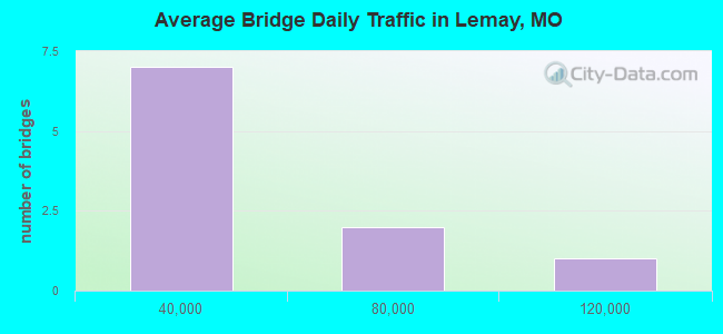
- 261,643Total average daily traffic
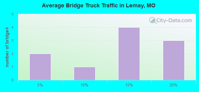
- 40,831Total average daily truck traffic
- National Bridge Inventory (NBI) Registered Bridges for Lemay
- No street view available for this location
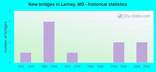
- New bridges - historical statistics
- 11950-1959
- 41960-1969
- 11970-1979
- 21990-1999
- 22000-2009
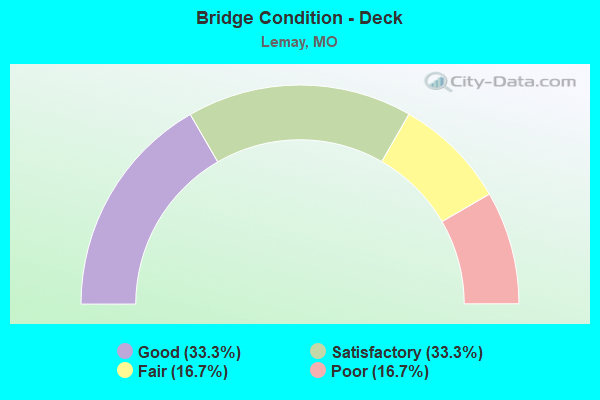
- Bridge Condition - Deck
- 33.3%Good
- 33.3%Satisfactory
- 16.7%Fair
- 16.7%Poor
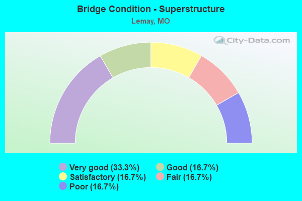
- Bridge Condition - Superstructure
- 33.3%Very good
- 16.7%Good
- 16.7%Satisfactory
- 16.7%Fair
- 16.7%Poor
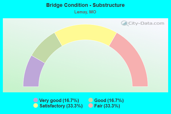
- Bridge Condition - Substructure
- 16.7%Very good
- 16.7%Good
- 33.3%Satisfactory
- 33.3%Fair
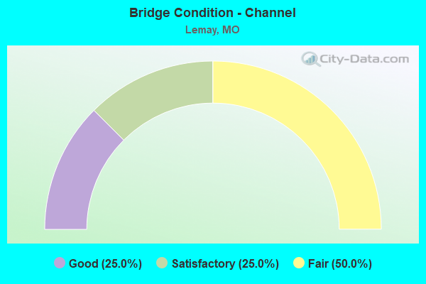
- Bridge Condition - Channel
- 25.0%Good
- 25.0%Satisfactory
- 50.0%Fair
Find on map >> Show street view
Structure Number: 1085, Location: S 35 T 44 N R 6 E (Lat: 38.502008, Lng: -90.322181), Route carried "on" structure: US 50, Year Built: 1969, Status: Open, Structure Length: 9.33m (30.61ft), Average Daily Traffic: 5,184 (year 2021), Truck Traffic: 10%, Average Future Daily Traffic: 7,258 (year 2041), Design Load: HS 20+Mod, Features Intersected: IS 255
Minimum Vertical Clearance: 30+ m (98+ ft), Kilometerpoint: 416.962, Lanes on structure: 1, Lanes under structure: 8, Base Highway Network: Yes, Owner: State Highway Agency, Approaching Roadway Width: 9.1m (29.9ft), Material/Design: Concrete continuous, Design/Construction: Box Beam or Girders - Single/Spread, Number Of Spans In Main Unit: 4, Length of Maximum Span: 28.0m (91.9ft), Curb-To-Curb Width: 7.3m (24.0ft), Out-to-Out Width: 8.1m (26.6ft)
Condition: Deck: Poor, Superstructure: Poor, Substructure: Satisfactory, Operating Rating: 72.0 metric tons, Method Used To Determine Operating Rating: Load Factor (LF), Inventory Rating: 43.2 metric tons, Method Used To Determine Inventory Rating: Load Factor (LF), Structural Evaluation: Meets minimum limits, Deck Geometry: High priority of replacement, Underclear: Meets minimum limits, Approach Roadway Alignment: Equal to present desirable criteria, Length Of Structure Improvement: 1.03m (3.38ft), Designated Inspection Frequency: Every 12 months, Inspection Date: July 2021, Bridge Improvement Cost: $1,237,000, Roadway Improvement Cost: $124,000, Total Project Cost: $1,855,000 ( Estimate for 2022), Deck Structure Type: Concrete Cast-file-Place, Wearing Surface/Protective System: Wearing Surface: Bituminous, Membrane: Built-up, Deck Protection: Cathodic Protection
Find on map >> Show street view
Structure Number: 15632, Location: S 24 T 44 N R 6 E (Lat: 38.526933, Lng: -90.299589), Route carried "on" structure: County highway , Year Built: 1954, Year Reconstructed: 1990, Status: Posted for load, Structure Length: 2.16m (7.09ft), Average Daily Traffic: 4,663 (year 2020), Truck Traffic: 3%, Average Future Daily Traffic: 6,295 (year 2040), Design Load: HS 20, Features Intersected: GRAVOIS CR, Facility Carried by Structure: GREEN PARK RD
Minimum Vertical Clearance: 30+ m (98+ ft), Kilometerpoint: 1.448, Lanes on structure: 2, Owner: County Highway Agency, Approaching Roadway Width: 5.8m (19.0ft), Material/Design: Prestressed concrete, Design/Construction: Box Beam or Girders - Multiple, Number Of Spans In Main Unit: 2, Length of Maximum Span: 9.1m (29.9ft), Curb-To-Curb Width: 6.1m (20.0ft), Out-to-Out Width: 6.4m (21.0ft)
Condition: Deck: Satisfactory, Superstructure: Satisfactory, Substructure: Fair, Channel: Fair, Operating Rating: 31.5 metric tons, Method Used To Determine Operating Rating: Allowable Stress (AS), Inventory Rating: 22.5 metric tons, Method Used To Determine Inventory Rating: Allowable Stress (AS), Structural Evaluation: Somewhat better than minimum adequacy, Deck Geometry: High priority of replacement, Waterway Adequacy: Somewhat better than minimum adequacy, Approach Roadway Alignment: Equal to present desirable criteria, Length Of Structure Improvement: 0.30m (0.98ft), Designated Inspection Frequency: Every 24 months, Inspection Date: Febuary 2020, Bridge Improvement Cost: $256,000, Roadway Improvement Cost: $26,000, Total Project Cost: $384,000 ( Estimate for 2022), Deck Structure Type: Other, Wearing Surface/Protective System: Wearing Surface: Bituminous
Find on map >> Show street view
Structure Number: 15635, Location: S 13 T 44 N R 6 E (Lat: 38.546289, Lng: -90.288875), Route carried "on" structure: County highway , Year Built: 1971, Status: Posted for load, Structure Length: 3.17m (10.40ft), Average Daily Traffic: 13,770 (year 2020), Truck Traffic: 10%, Average Future Daily Traffic: 18,590 (year 2040), Design Load: H 20, Features Intersected: GRAVOIS CR, Facility Carried by Structure: BAYLESS AVE
Minimum Vertical Clearance: 30+ m (98+ ft), Kilometerpoint: 3.058, Lanes on structure: 4, Owner: County Highway Agency, Approaching Roadway Width: 14.6m (47.9ft), Material/Design: Concrete, Design/Construction: Tee Beam, Number Of Spans In Main Unit: 2, Length of Maximum Span: 13.7m (44.9ft), Curb or Sidewalk Widths: Left: 1.5m (4.9ft), Right: 1.5m (4.9ft), Curb-To-Curb Width: 14.6m (47.9ft), Out-to-Out Width: 18.2m (59.7ft)
Condition: Deck: Fair, Superstructure: Fair, Substructure: Fair, Channel: Satisfactory, Operating Rating: 63.0 metric tons, Method Used To Determine Operating Rating: Allowable Stress (AS), Inventory Rating: 22.5 metric tons, Method Used To Determine Inventory Rating: Allowable Stress (AS), Structural Evaluation: Somewhat better than minimum adequacy, Deck Geometry: High priority of replacement, Waterway Adequacy: Somewhat better than minimum adequacy, Approach Roadway Alignment: Equal to present desirable criteria, Length Of Structure Improvement: 0.40m (1.31ft), Designated Inspection Frequency: Every 24 months, Inspection Date: June 2021, Bridge Improvement Cost: $786,000, Roadway Improvement Cost: $79,000, Total Project Cost: $1,179,000 ( Estimate for 2022), Deck Structure Type: Concrete Cast-file-Place, Wearing Surface/Protective System: Wearing Surface: Bituminous
Find on map >> Show street view
Structure Number: 32967, Location: S 19 T 44 N R 6 E (Lat: 38.533889, Lng: -90.263889), Route carried "on" structure: County highway , Year Built: 2009, Status: Open, Structure Length: 13.26m (43.50ft), Average Daily Traffic: 8,029 (year 2020), Truck Traffic: 5%, Average Future Daily Traffic: 10,839 (year 2040), Design Load: HS 20, Features Intersected: UP RR, Facility Carried by Structure: RIVER CITY CASINO
Minimum Vertical Clearance: 30+ m (98+ ft), Kilometerpoint: 0.000, Lanes on structure: 4, Owner: County Highway Agency, Approaching Roadway Width: 15.8m (51.8ft), Material/Design: Steel continuous, Design/Construction: Stringer/Multi-beam, Number Of Spans In Main Unit: 6, Length of Maximum Span: 36.6m (120.1ft), Curb or Sidewalk Widths: Left: 0.0m, Right: 1.8m (5.9ft), Curb-To-Curb Width: 15.8m (51.8ft), Out-to-Out Width: 18.4m (60.4ft)
Condition: Deck: Good, Superstructure: Very good, Substructure: Good, Inventory Rating: 71.1 metric tons, Method Used To Determine Inventory Rating: Load Factor (LF), Structural Evaluation: Better than present minimum criteria, Deck Geometry: Meets minimum limits, Underclear: Superior to present desirable criteria, Approach Roadway Alignment: Equal to present desirable criteria, Designated Inspection Frequency: Every 24 months, Inspection Date: April 2020, Deck Structure Type: Concrete Precast Panels, Wearing Surface/Protective System: Wearing Surface: Monolithic Concrete, Membrane: Built-up, Deck Protection: Other
Find on map >> Show street view
Structure Number: 32969, Location: S 12 T 44 N R 6 E (Lat: 38.548056, Lng: -90.272222), Route carried "on" structure: County highway , Year Built: 2009, Status: Open, Structure Length: 3.05m (10.01ft), Average Daily Traffic: 10,746 (year 2020), Truck Traffic: 2%, Average Future Daily Traffic: 14,507 (year 2040), Design Load: HS 20, Features Intersected: GRAVOIS CR, Facility Carried by Structure: RIVER CITY BLVD
Minimum Vertical Clearance: 30+ m (98+ ft), Kilometerpoint: 0.000, Lanes on structure: 4, Owner: County Highway Agency, Approaching Roadway Width: 12.8m (42.0ft), Skew: 2 degrees, Material/Design: Prestressed concrete, Design/Construction: Stringer/Multi-beam, Number Of Spans In Main Unit: 1, Length of Maximum Span: 28.7m (94.2ft), Curb or Sidewalk Widths: Left: 0.0m, Right: 1.8m (5.9ft), Curb-To-Curb Width: 12.9m (42.3ft), Out-to-Out Width: 15.5m (50.9ft)
Condition: Deck: Good, Superstructure: Very good, Substructure: Very good, Channel: Good, Inventory Rating: 63.0 metric tons, Method Used To Determine Inventory Rating: Load Factor (LF), Structural Evaluation: Equal to present desirable criteria, Deck Geometry: High priority of replacement, Waterway Adequacy: Superior to present desirable criteria, Approach Roadway Alignment: Equal to present minimum criteria, Length Of Structure Improvement: 0.39m (1.28ft), Designated Inspection Frequency: Every 24 months, Inspection Date: June 2021, Bridge Improvement Cost: $522,000, Roadway Improvement Cost: $52,000, Total Project Cost: $783,000 ( Estimate for 2022), Deck Structure Type: Concrete Cast-file-Place, Wearing Surface/Protective System: Wearing Surface: Monolithic Concrete, Membrane: Built-up, Deck Protection: Other
Find on map >> Show street view
Structure Number: 4094, Location: S 302 T 44 N R 6 E (Lat: 38.502628, Lng: -90.335358), Route carried "on" structure: Ramp State highway , Year Built: 1995, Status: Open, Structure Length: 12.44m (40.81ft), Average Daily Traffic: 8,338 (year 2021), Truck Traffic: 10%, Average Future Daily Traffic: 10,423 (year 2041), Design Load: HS 20+Mod, Features Intersected: RP IS55N TO IS255S, RP I, Facility Carried by Structure: RP IS270W TO US67
Minimum Vertical Clearance: 30+ m (98+ ft), Kilometerpoint: 1.371, Lanes on structure: 1, Lanes under structure: 3, Base Highway Network: Yes, Owner: State Highway Agency, Approaching Roadway Width: 8.8m (28.9ft), Skew: 6 degrees, Material/Design: Steel continuous, Design/Construction: Stringer/Multi-beam, Number Of Spans In Main Unit: 4, Length of Maximum Span: 37.5m (123.0ft), Curb or Sidewalk Widths: Left: 0.2m (0.7ft), Right: 0.2m (0.7ft), Curb-To-Curb Width: 8.5m (27.9ft), Out-to-Out Width: 9.6m (31.5ft)
Condition: Deck: Satisfactory, Superstructure: Good, Substructure: Satisfactory, Operating Rating: 77.4 metric tons, Method Used To Determine Operating Rating: Load Factor (LF), Inventory Rating: 46.8 metric tons, Method Used To Determine Inventory Rating: Load Factor (LF), Structural Evaluation: Equal to present minimum criteria, Deck Geometry: Superior to present desirable criteria, Underclear: Somewhat better than minimum adequacy, Approach Roadway Alignment: Equal to present desirable criteria, Designated Inspection Frequency: Every 24 months, Inspection Date: July 2020, Deck Structure Type: Concrete Cast-file-Place, Wearing Surface/Protective System: Wearing Surface: Monolithic Concrete, Deck Protection: Epoxy Coated Reinforcing
Find on map >> Show street view
Structure Number: 734, Location: S 24 T 44 N R 6 E (Lat: 38.540581, Lng: -90.302064), Route carried "on" structure: Interstate 55, Year Built: 1962, Status: Open, Structure Length: 1.58m (5.18ft), Average Daily Traffic: 115,059 (year 2021), Truck Traffic: 18%, Average Future Daily Traffic: 143,824 (year 2041), Design Load: HS 20, Features Intersected: AFTON DRAIN DTCH
Minimum Vertical Clearance: 30+ m (98+ ft), Kilometerpoint: 15.347, Lanes on structure: 9, Base Highway Network: Yes, Owner: State Highway Agency, Approaching Roadway Width: 39.0m (128.0ft), Skew: 25 degrees, Material/Design: Concrete continuous, Design/Construction: Culvert, Number Of Spans In Main Unit: 3, Length of Maximum Span: 2.7m (8.9ft)
Condition: Channel: Fair, Culverts: Fair, Operating Rating: 81.9 metric tons, Method Used To Determine Operating Rating: Load Factor (LF), Inventory Rating: 48.6 metric tons, Method Used To Determine Inventory Rating: Load Factor (LF), Structural Evaluation: Somewhat better than minimum adequacy, Waterway Adequacy: Equal to present minimum criteria, Approach Roadway Alignment: Equal to present desirable criteria, Designated Inspection Frequency: Every 24 months, Inspection Date: November 2021
Find on map >> Show street view
Structure Number: 1085, Location: S 35 T 44 N R 6 E (Lat: 38.502008, Lng: -90.322181), Route carried "under" structure: Interstate 255, Year Built: 1969, Structure Length: 0. m, Average Daily Traffic: 44,369 (year 2021), Truck Traffic: 18%, Features Intersected: IS 255, Facility Carried by Structure: US 50 E
Minimum Vertical Clearance: 4.85m (15.91ft), Kilometerpoint: 1.881, Lanes on structure: 1, Lanes under structure: 4, Material/Design: Concrete continuous, Design/Construction: Box Beam or Girders - Single/Spread, Length of Maximum Span: 28.0m (91.9ft)
Find on map >> Show street view
Structure Number: 1085, Location: S 35 T 44 N R 6 E (Lat: 38.502008, Lng: -90.322181), Route carried "under" structure: Interstate 255, Year Built: 1969, Structure Length: 0. m, Average Daily Traffic: 43,818 (year 2021), Truck Traffic: 18%, Features Intersected: IS 255, Facility Carried by Structure: US 50 E
Minimum Vertical Clearance: 4.78m (15.68ft), Kilometerpoint: 4.538, Lanes on structure: 1, Lanes under structure: 4, Material/Design: Concrete continuous, Design/Construction: Box Beam or Girders - Single/Spread, Length of Maximum Span: 28.0m (91.9ft)
Find on map >> Show street view
Structure Number: 4094, Location: S 302 T 44 N R 6 E (Lat: 38.502628, Lng: -90.335358), Route carried "under" structure: Ramp State highway , Year Built: 1995, Structure Length: 0. m, Average Daily Traffic: 7,667 (year 2021), Truck Traffic: 10%, Features Intersected: RP IS55N TO IS255S, Facility Carried by Structure: RP IS270W TO US67
Minimum Vertical Clearance: 5.00m (16.40ft), Kilometerpoint: 0.694, Lanes on structure: 1, Lanes under structure: 2, Material/Design: Steel continuous, Design/Construction: Stringer/Multi-beam, Length of Maximum Span: 37.5m (123.0ft)