Bridge Statistics for Lesslie, South Carolina (SC)
Condition, Traffic, Stress, Structural Evaluation, Project Costs
- National Bridge Inventory (NBI) Statistics
- 19Number of bridges
- 217ft / 66.0mTotal length
- $306,000Total costs
- 222,400Total average daily traffic
- 36,976Total average daily truck traffic
- National Bridge Inventory (NBI) Registered Bridges for Lesslie
- No street view available for this location
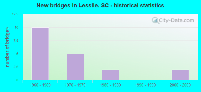
- New bridges - historical statistics
- 101960-1969
- 51970-1979
- 21980-1989
- 22000-2009


- Bridge Condition - Deck
- 15.4%Very good
- 23.1%Good
- 30.8%Satisfactory
- 30.8%Fair

- Bridge Condition - Superstructure
- 23.1%Very good
- 15.4%Good
- 23.1%Satisfactory
- 38.5%Fair

- Bridge Condition - Substructure
- 15.4%Very good
- 38.5%Good
- 23.1%Satisfactory
- 23.1%Fair

- Bridge Condition - Channel
- 20.0%Very good
- 20.0%Good
- 40.0%Satisfactory
- 20.0%Fair
Find on map >> Show street view
Structure Number: 755, Location: 6.2 MI SE ROCK HILL (Lat: 34.869428, Lng: -80.937675), Route carried "on" structure: State highway 6, Year Built: 2002, Status: Open, Structure Length: 5.00m (16.40ft), Average Daily Traffic: 5,600 (year 2020), Truck Traffic: 7%, Average Future Daily Traffic: 7,448 (year 2040), Design Load: HS 20, Features Intersected: RR NS
Minimum Vertical Clearance: 30+ m (98+ ft), Kilometerpoint: 0.686, Lanes on structure: 2, Owner: State Highway Agency, Approaching Roadway Width: 11.0m (36.1ft), Skew: 2 degrees, Material/Design: Steel continuous, Design/Construction: Stringer/Multi-beam, Number Of Spans In Main Unit: 3, Length of Maximum Span: 19.5m (64.0ft), Curb-To-Curb Width: 10.4m (34.1ft), Out-to-Out Width: 11.2m (36.7ft)
Condition: Deck: Good, Superstructure: Very good, Substructure: Very good, Operating Rating: 22.7 metric tons, Method Used To Determine Operating Rating: Load and Resistance Factor Rating (LRFR) rating reported by rating factor(RF) method using HL-93 loadings, Inventory Rating: 16.2 metric tons, Method Used To Determine Inventory Rating: Load and Resistance Factor Rating (LRFR) rating reported by rating factor(RF) method using HL-93 loadings, Structural Evaluation: Meets minimum limits, Deck Geometry: Meets minimum limits, Underclear: Superior to present desirable criteria, Approach Roadway Alignment: Equal to present minimum criteria, Length Of Structure Improvement: 5.00m (16.40ft), Designated Inspection Frequency: Every 24 months, Inspection Date: May 2021, Deck Structure Type: Concrete Cast-file-Place, Wearing Surface/Protective System: Wearing Surface: Monolithic Concrete
Find on map >> Show street view
Structure Number: 2637, Location: 6.5 MI S ROCK HILL (Lat: 34.839778, Lng: -80.978808), Route carried "on" structure: State highway 162, Year Built: 2006, Status: Open, Structure Length: 1.52m (4.99ft), Average Daily Traffic: 1,400 (year 2020), Truck Traffic: 6%, Average Future Daily Traffic: 2,954 (year 2040), Design Load: HS 20, Features Intersected: BR TO NEELYS CREEK
Minimum Vertical Clearance: 30+ m (98+ ft), Kilometerpoint: 6.027, Lanes on structure: 2, Owner: State Highway Agency, Approaching Roadway Width: 10.1m (33.1ft), Material/Design: Prestressed concrete, Design/Construction: Box Beam or Girders - Multiple, Number Of Spans In Main Unit: 1, Length of Maximum Span: 15.2m (49.9ft), Curb-To-Curb Width: 10.0m (32.8ft), Out-to-Out Width: 10.9m (35.8ft)
Condition: Deck: Very good, Superstructure: Very good, Substructure: Very good, Channel: Good, Operating Rating: 39.5 metric tons, Method Used To Determine Operating Rating: Load and Resistance Factor Rating (LRFR) rating reported by rating factor(RF) method using HL-93 loadings, Inventory Rating: 29.5 metric tons, Method Used To Determine Inventory Rating: Load and Resistance Factor Rating (LRFR) rating reported by rating factor(RF) method using HL-93 loadings, Structural Evaluation: Better than present minimum criteria, Deck Geometry: Somewhat better than minimum adequacy, Waterway Adequacy: Better than present minimum criteria, Approach Roadway Alignment: Equal to present desirable criteria, Length Of Structure Improvement: 1.52m (4.99ft), Designated Inspection Frequency: Every 24 months, Inspection Date: May 2021, Deck Structure Type: Concrete Precast Panels, Wearing Surface/Protective System: Wearing Surface: Bituminous
Find on map >> Show street view
Structure Number: 4012, Location: 6.6 MI E ROCK HILL (Lat: 34.900569, Lng: -80.912308), Route carried "on" structure: State highway 734, Year Built: 1962, Status: Posted for load, Structure Length: 2.29m (7.51ft), Average Daily Traffic: 650 (year 2020), Truck Traffic: 5%, Average Future Daily Traffic: 832 (year 2040), Design Load: H 10, Features Intersected: BR TO CATAWBA RIVER
Minimum Vertical Clearance: 30+ m (98+ ft), Kilometerpoint: 0.249, Lanes on structure: 2, Owner: State Highway Agency, Approaching Roadway Width: 9.1m (29.9ft), Material/Design: Concrete, Design/Construction: Slab, Number Of Spans In Main Unit: 5, Length of Maximum Span: 4.6m (15.1ft), Curb-To-Curb Width: 8.0m (26.2ft), Out-to-Out Width: 8.4m (27.6ft)
Condition: Deck: Fair, Superstructure: Satisfactory, Substructure: Fair, Channel: Fair, Operating Rating: 19.1 metric tons, Method Used To Determine Operating Rating: Load and Resistance Factor Rating (LRFR) rating reported by rating factor(RF) method using HL-93 loadings, Inventory Rating: 14.9 metric tons, Method Used To Determine Inventory Rating: Load and Resistance Factor Rating (LRFR) rating reported by rating factor(RF) method using HL-93 loadings, Structural Evaluation: Meets minimum limits, Deck Geometry: Somewhat better than minimum adequacy, Waterway Adequacy: Equal to present desirable criteria, Approach Roadway Alignment: Equal to present desirable criteria, Bridge Posting: Required (Relationship of Operating Rating to Maximum Legal Load: 30.0 - 39.9% below), Length Of Structure Improvement: 2.29m (7.51ft), Designated Inspection Frequency: Every 24 months, Other Special Inspection Frequency: Every 24 months, Inspection Date: May 2020, Other Special Inspection Date: August 2021, Deck Structure Type: Concrete Precast Panels, Wearing Surface/Protective System: Wearing Surface: Bituminous
Find on map >> Show street view
Structure Number: 468, Location: 4.6 MI SE ROCK HILL (Lat: 34.893308, Lng: -80.953200), Route carried "on" structure: State highway 31, Year Built: 1965, Status: Open, Structure Length: 6.89m (22.60ft), Average Daily Traffic: 1,950 (year 2021), Truck Traffic: 5%, Average Future Daily Traffic: 2,594 (year 2041), Design Load: HS 15, Features Intersected: U.S. 21
Minimum Vertical Clearance: 5.13m (16.83ft), Kilometerpoint: 9.955, Lanes on structure: 2, Lanes under structure: 4, Owner: State Highway Agency, Approaching Roadway Width: 8.5m (27.9ft), Skew: 1 degrees, Material/Design: Prestressed concrete, Design/Construction: Stringer/Multi-beam, Number Of Spans In Main Unit: 4, Length of Maximum Span: 18.3m (60.0ft), Curb-To-Curb Width: 8.5m (27.9ft), Out-to-Out Width: 10.2m (33.5ft)
Condition: Deck: Good, Superstructure: Fair, Substructure: Satisfactory, Operating Rating: 35.0 metric tons, Method Used To Determine Operating Rating: Load and Resistance Factor Rating (LRFR) rating reported by rating factor(RF) method using HL-93 loadings, Inventory Rating: 26.9 metric tons, Method Used To Determine Inventory Rating: Load and Resistance Factor Rating (LRFR) rating reported by rating factor(RF) method using HL-93 loadings, Structural Evaluation: Somewhat better than minimum adequacy, Deck Geometry: Somewhat better than minimum adequacy, Underclear: Equal to present minimum criteria, Approach Roadway Alignment: Equal to present desirable criteria, Length Of Structure Improvement: 6.89m (22.60ft), Designated Inspection Frequency: Every 24 months, Inspection Date: May 2021, Deck Structure Type: Concrete Cast-file-Place, Wearing Surface/Protective System: Wearing Surface: Monolithic Concrete
Find on map >> Show street view
Structure Number: 4681, Location: 3.3 MI E ROCK HILL (Lat: 34.911644, Lng: -80.968272), Route carried "on" structure: State highway 50, Year Built: 1965, Status: Open, Structure Length: 6.71m (22.01ft), Average Daily Traffic: 1,200 (year 2020), Truck Traffic: 6%, Average Future Daily Traffic: 1,596 (year 2040), Design Load: HS 15, Features Intersected: US 21
Minimum Vertical Clearance: 6.10m (20.01ft), Kilometerpoint: 1.745, Lanes on structure: 2, Lanes under structure: 4, Owner: State Highway Agency, Approaching Roadway Width: 7.3m (24.0ft), Material/Design: Steel, Design/Construction: Stringer/Multi-beam, Number Of Spans In Main Unit: 4, Length of Maximum Span: 16.8m (55.1ft), Curb-To-Curb Width: 8.5m (27.9ft), Out-to-Out Width: 9.8m (32.2ft)
Condition: Deck: Fair, Superstructure: Fair, Substructure: Good, Operating Rating: 47.6 metric tons, Method Used To Determine Operating Rating: Load and Resistance Factor Rating (LRFR) rating reported by rating factor(RF) method using HL-93 loadings, Inventory Rating: 36.6 metric tons, Method Used To Determine Inventory Rating: Load and Resistance Factor Rating (LRFR) rating reported by rating factor(RF) method using HL-93 loadings, Structural Evaluation: Somewhat better than minimum adequacy, Deck Geometry: Somewhat better than minimum adequacy, Underclear: Meets minimum limits, Approach Roadway Alignment: Equal to present desirable criteria, Length Of Structure Improvement: 6.71m (22.01ft), Designated Inspection Frequency: Every 24 months, Inspection Date: May 2021, Deck Structure Type: Concrete Cast-file-Place, Wearing Surface/Protective System: Wearing Surface: Monolithic Concrete
Find on map >> Show street view
Structure Number: 4682, Location: 5.7 MI SE ROCK HILL (Lat: 34.880719, Lng: -80.939617), Route carried "on" structure: State highway 558, Year Built: 1965, Status: Open, Structure Length: 6.80m (22.31ft), Average Daily Traffic: 350 (year 2020), Truck Traffic: 5%, Average Future Daily Traffic: 448 (year 2040), Design Load: H 15, Features Intersected: U.S. 21
Minimum Vertical Clearance: 4.88m (16.01ft), Kilometerpoint: 1.331, Lanes on structure: 2, Lanes under structure: 4, Owner: State Highway Agency, Approaching Roadway Width: 8.2m (26.9ft), Material/Design: Prestressed concrete, Design/Construction: Stringer/Multi-beam, Number Of Spans In Main Unit: 4, Length of Maximum Span: 18.6m (61.0ft), Curb-To-Curb Width: 7.9m (25.9ft), Out-to-Out Width: 9.6m (31.5ft)
Condition: Deck: Satisfactory, Superstructure: Fair, Substructure: Satisfactory, Operating Rating: 38.9 metric tons, Method Used To Determine Operating Rating: Load and Resistance Factor Rating (LRFR) rating reported by rating factor(RF) method using HL-93 loadings, Inventory Rating: 21.7 metric tons, Method Used To Determine Inventory Rating: Load and Resistance Factor Rating (LRFR) rating reported by rating factor(RF) method using HL-93 loadings, Structural Evaluation: Somewhat better than minimum adequacy, Deck Geometry: Somewhat better than minimum adequacy, Underclear: Somewhat better than minimum adequacy, Approach Roadway Alignment: Equal to present minimum criteria, Length Of Structure Improvement: 6.77m (22.21ft), Designated Inspection Frequency: Every 24 months, Inspection Date: May 2021, Deck Structure Type: Concrete Cast-file-Place, Wearing Surface/Protective System: Wearing Surface: Monolithic Concrete
Find on map >> Show street view
Structure Number: 4908, Location: 6.5 MI SE ROCK HILL (Lat: 34.874878, Lng: -80.931386), Route carried "on" structure: State highway 160, Year Built: 1966, Status: Open, Structure Length: 7.07m (23.20ft), Average Daily Traffic: 1,500 (year 2020), Truck Traffic: 7%, Average Future Daily Traffic: 1,995 (year 2040), Design Load: HS 15, Features Intersected: US 21
Minimum Vertical Clearance: 30+ m (98+ ft), Kilometerpoint: 0.737, Lanes on structure: 2, Lanes under structure: 4, Owner: State Highway Agency, Approaching Roadway Width: 9.1m (29.9ft), Skew: 2 degrees, Material/Design: Steel, Design/Construction: Stringer/Multi-beam, Number Of Spans In Main Unit: 4, Length of Maximum Span: 18.3m (60.0ft), Curb-To-Curb Width: 8.6m (28.2ft), Out-to-Out Width: 9.8m (32.2ft)
Condition: Deck: Satisfactory, Superstructure: Satisfactory, Substructure: Good, Operating Rating: 50.2 metric tons, Method Used To Determine Operating Rating: Load and Resistance Factor Rating (LRFR) rating reported by rating factor(RF) method using HL-93 loadings, Inventory Rating: 38.6 metric tons, Method Used To Determine Inventory Rating: Load and Resistance Factor Rating (LRFR) rating reported by rating factor(RF) method using HL-93 loadings, Structural Evaluation: Equal to present minimum criteria, Deck Geometry: Somewhat better than minimum adequacy, Underclear: Somewhat better than minimum adequacy, Approach Roadway Alignment: Equal to present minimum criteria, Length Of Structure Improvement: 7.07m (23.20ft), Designated Inspection Frequency: Every 24 months, Inspection Date: June 2021, Deck Structure Type: Concrete Cast-file-Place, Wearing Surface/Protective System: Wearing Surface: Monolithic Concrete
Find on map >> Show street view
Structure Number: 4964, Location: 1MI NE EDGEMOOR (Lat: 34.814675, Lng: -80.989278), Route carried "on" structure: State highway 525, Year Built: 1967, Status: Posted for load, Structure Length: 1.83m (6.00ft), Average Daily Traffic: 150 (year 2020), Truck Traffic: 5%, Average Future Daily Traffic: 192 (year 2040), Design Load: H 10, Features Intersected: WHITESIDES BRANCH
Minimum Vertical Clearance: 30+ m (98+ ft), Kilometerpoint: 1.078, Lanes on structure: 2, Owner: State Highway Agency, Approaching Roadway Width: 9.1m (29.9ft), Material/Design: Concrete, Design/Construction: Slab, Number Of Spans In Main Unit: 4, Length of Maximum Span: 4.6m (15.1ft), Curb-To-Curb Width: 8.0m (26.2ft), Out-to-Out Width: 8.4m (27.6ft)
Condition: Deck: Fair, Superstructure: Fair, Substructure: Fair, Channel: Satisfactory, Operating Rating: 12.0 metric tons, Method Used To Determine Operating Rating: Load and Resistance Factor Rating (LRFR) rating reported by rating factor(RF) method using HL-93 loadings, Inventory Rating: 9.4 metric tons, Method Used To Determine Inventory Rating: Load and Resistance Factor Rating (LRFR) rating reported by rating factor(RF) method using HL-93 loadings, Structural Evaluation: High priority of replacement, Deck Geometry: Somewhat better than minimum adequacy, Waterway Adequacy: Equal to present desirable criteria, Approach Roadway Alignment: Equal to present desirable criteria, Bridge Posting: Required (Relationship of Operating Rating to Maximum Legal Load: > 39.9% below), Length Of Structure Improvement: 2.56m (8.40ft), Designated Inspection Frequency: Every 24 months, Inspection Date: Febuary 2020, Bridge Improvement Cost: $204,000, Roadway Improvement Cost: $51,000, Total Project Cost: $306,000 ( Estimate for 2021), Deck Structure Type: Concrete Precast Panels, Wearing Surface/Protective System: Wearing Surface: Bituminous
Find on map >> Show street view
Structure Number: 6816, Location: 2.6 MI S OF ROCK HILL (Lat: 34.913333, Lng: -80.982500), Route carried "on" structure: US 21, Year Built: 1975, Status: Open, Structure Length: 8.23m (27.00ft), Average Daily Traffic: 22,000 (year 2020), Truck Traffic: 21%, Average Future Daily Traffic: 28,820 (year 2040), Design Load: HS 20, Features Intersected: I-77
Minimum Vertical Clearance: 30+ m (98+ ft), Kilometerpoint: 12.704, Lanes on structure: 4, Lanes under structure: 6, Base Highway Network: Yes, Owner: State Highway Agency, Approaching Roadway Width: 26.8m (87.9ft), Skew: 20 degrees, Material/Design: Steel, Design/Construction: Frame, Number Of Spans In Main Unit: 2, Number Of Approach Spans: 2, Length of Maximum Span: 27.4m (89.9ft), Curb or Sidewalk Widths: Left: 0.0m, Right: 1.4m (4.6ft), Curb-To-Curb Width: 24.4m (80.1ft), Out-to-Out Width: 26.8m (87.9ft)
Condition: Deck: Fair, Superstructure: Satisfactory, Substructure: Satisfactory, Operating Rating: 38.6 metric tons, Method Used To Determine Operating Rating: Load and Resistance Factor Rating (LRFR) rating reported by rating factor(RF) method using HL-93 loadings, Inventory Rating: 29.8 metric tons, Method Used To Determine Inventory Rating: Load and Resistance Factor Rating (LRFR) rating reported by rating factor(RF) method using HL-93 loadings, Structural Evaluation: Equal to present minimum criteria, Deck Geometry: Superior to present desirable criteria, Underclear: High priority of corrective action, Approach Roadway Alignment: Equal to present desirable criteria, Length Of Structure Improvement: 8.23m (27.00ft), Designated Inspection Frequency: Every 24 months, Inspection Date: June 2020, Deck Structure Type: Concrete Cast-file-Place, Wearing Surface/Protective System: Wearing Surface: Monolithic Concrete
Find on map >> Show street view
Structure Number: 6826, Location: 5.8 MI SE ROCK HILL (Lat: 34.887994, Lng: -80.923367), Route carried "on" structure: State highway 559, Year Built: 1975, Status: Posted for load, Structure Length: 1.83m (6.00ft), Average Daily Traffic: 350 (year 2020), Truck Traffic: 5%, Average Future Daily Traffic: 448 (year 2040), Design Load: H 10, Features Intersected: BR. CATAWBA RIVER
Minimum Vertical Clearance: 30+ m (98+ ft), Kilometerpoint: 2.741, Lanes on structure: 2, Owner: State Highway Agency, Approaching Roadway Width: 11.3m (37.1ft), Material/Design: Concrete, Design/Construction: Slab, Number Of Spans In Main Unit: 4, Length of Maximum Span: 4.6m (15.1ft), Curb-To-Curb Width: 11.3m (37.1ft), Out-to-Out Width: 11.7m (38.4ft)
Condition: Deck: Satisfactory, Superstructure: Fair, Substructure: Fair, Channel: Satisfactory, Operating Rating: 19.1 metric tons, Method Used To Determine Operating Rating: Load and Resistance Factor Rating (LRFR) rating reported by rating factor(RF) method using HL-93 loadings, Inventory Rating: 14.9 metric tons, Method Used To Determine Inventory Rating: Load and Resistance Factor Rating (LRFR) rating reported by rating factor(RF) method using HL-93 loadings, Structural Evaluation: Meets minimum limits, Deck Geometry: Superior to present desirable criteria, Waterway Adequacy: Equal to present desirable criteria, Approach Roadway Alignment: Equal to present desirable criteria, Bridge Posting: Required (Relationship of Operating Rating to Maximum Legal Load: 30.0 - 39.9% below), Length Of Structure Improvement: 1.83m (6.00ft), Designated Inspection Frequency: Every 24 months, Other Special Inspection Frequency: Every 24 months, Inspection Date: April 2020, Other Special Inspection Date: August 2021, Deck Structure Type: Concrete Precast Panels, Wearing Surface/Protective System: Wearing Surface: Bituminous
Find on map >> Show street view
Structure Number: 7186, Location: 2.9 MI SE ROCK HILL (Lat: 34.904986, Lng: -80.986761), Route carried "on" structure: State highway 710, Year Built: 1978, Status: Open, Structure Length: 9.02m (29.59ft), Average Daily Traffic: 5,900 (year 2020), Truck Traffic: 4%, Average Future Daily Traffic: 7,847 (year 2040), Design Load: HS 15, Features Intersected: I-77
Minimum Vertical Clearance: 5.56m (18.24ft), Kilometerpoint: 1.574, Lanes on structure: 2, Lanes under structure: 4, Owner: State Highway Agency, Approaching Roadway Width: 12.2m (40.0ft), Skew: 2 degrees, Material/Design: Steel, Design/Construction: Stringer/Multi-beam, Number Of Spans In Main Unit: 2, Number Of Approach Spans: 2, Length of Maximum Span: 28.0m (91.9ft), Curb-To-Curb Width: 12.2m (40.0ft), Out-to-Out Width: 13.2m (43.3ft)
Condition: Deck: Good, Superstructure: Good, Substructure: Good, Operating Rating: 52.2 metric tons, Method Used To Determine Operating Rating: Load and Resistance Factor Rating (LRFR) rating reported by rating factor(RF) method using HL-93 loadings, Inventory Rating: 40.2 metric tons, Method Used To Determine Inventory Rating: Load and Resistance Factor Rating (LRFR) rating reported by rating factor(RF) method using HL-93 loadings, Structural Evaluation: Better than present minimum criteria, Deck Geometry: Somewhat better than minimum adequacy, Underclear: Better than present minimum criteria, Approach Roadway Alignment: Equal to present desirable criteria, Length Of Structure Improvement: 9.02m (29.59ft), Designated Inspection Frequency: Every 24 months, Inspection Date: May 2021, Deck Structure Type: Concrete Cast-file-Place, Wearing Surface/Protective System: Wearing Surface: Monolithic Concrete
Find on map >> Show street view
Structure Number: 7633, Location: 7.1 MI SE ROCK HILL (Lat: 34.830986, Lng: -80.978664), Route carried "on" structure: State highway 52, Year Built: 1982, Status: Open, Structure Length: 4.21m (13.81ft), Average Daily Traffic: 1,950 (year 2020), Truck Traffic: 3%, Average Future Daily Traffic: 2,496 (year 2040), Design Load: HS 15, Features Intersected: RR CSXT
Minimum Vertical Clearance: 30+ m (98+ ft), Kilometerpoint: 1.427, Lanes on structure: 2, Owner: State Highway Agency, Approaching Roadway Width: 10.7m (35.1ft), Skew: 1 degrees, Material/Design: Steel, Design/Construction: Stringer/Multi-beam, Number Of Spans In Main Unit: 3, Length of Maximum Span: 14.0m (45.9ft), Curb-To-Curb Width: 9.8m (32.2ft), Out-to-Out Width: 10.8m (35.4ft)
Condition: Deck: Satisfactory, Superstructure: Good, Substructure: Good, Operating Rating: 60.9 metric tons, Method Used To Determine Operating Rating: Load and Resistance Factor Rating (LRFR) rating reported by rating factor(RF) method using HL-93 loadings, Inventory Rating: 47.0 metric tons, Method Used To Determine Inventory Rating: Load and Resistance Factor Rating (LRFR) rating reported by rating factor(RF) method using HL-93 loadings, Structural Evaluation: Better than present minimum criteria, Deck Geometry: Somewhat better than minimum adequacy, Underclear: Somewhat better than minimum adequacy, Approach Roadway Alignment: Equal to present minimum criteria, Length Of Structure Improvement: 4.21m (13.81ft), Designated Inspection Frequency: Every 24 months, Inspection Date: May 2021, Deck Structure Type: Concrete Cast-file-Place, Wearing Surface/Protective System: Wearing Surface: Monolithic Concrete
Find on map >> Show street view
Structure Number: 812, Location: 7.0 MI E ROCK HILL (Lat: 34.894514, Lng: -80.908825), Route carried "on" structure: State highway 160, Year Built: 1987, Status: Open, Structure Length: 4.57m (14.99ft), Average Daily Traffic: 3,700 (year 2020), Truck Traffic: 3%, Average Future Daily Traffic: 4,921 (year 2040), Design Load: HS 20, Features Intersected: BR TO CATAWBA RIVER
Minimum Vertical Clearance: 30+ m (98+ ft), Kilometerpoint: 4.228, Lanes on structure: 2, Owner: State Highway Agency, Approaching Roadway Width: 11.0m (36.1ft), Material/Design: Concrete, Design/Construction: Slab, Number Of Spans In Main Unit: 5, Length of Maximum Span: 9.1m (29.9ft), Curb-To-Curb Width: 9.8m (32.2ft), Out-to-Out Width: 10.9m (35.8ft)
Condition: Deck: Very good, Superstructure: Very good, Substructure: Good, Channel: Very good, Operating Rating: 42.1 metric tons, Method Used To Determine Operating Rating: Load and Resistance Factor Rating (LRFR) rating reported by rating factor(RF) method using HL-93 loadings, Inventory Rating: 32.4 metric tons, Method Used To Determine Inventory Rating: Load and Resistance Factor Rating (LRFR) rating reported by rating factor(RF) method using HL-93 loadings, Structural Evaluation: Better than present minimum criteria, Deck Geometry: Meets minimum limits, Waterway Adequacy: Equal to present desirable criteria, Approach Roadway Alignment: Equal to present minimum criteria, Length Of Structure Improvement: 4.57m (14.99ft), Designated Inspection Frequency: Every 24 months, Inspection Date: June 2021, Deck Structure Type: Concrete Cast-file-Place, Wearing Surface/Protective System: Wearing Surface: Monolithic Concrete
Find on map >> Show street view
Structure Number: 468, Location: 4.6 MI SE ROCK HILL (Lat: 34.893308, Lng: -80.953200), Route carried "under" structure: US 21, Year Built: 1965, Structure Length: 0. m, Average Daily Traffic: 20,500 (year 2021), Truck Traffic: 8%, Features Intersected: U.S. 21, Facility Carried by Structure: S-46-31
Minimum Vertical Clearance: 5.13m (16.83ft), Kilometerpoint: 8.964, Lanes on structure: 2, Lanes under structure: 4, Material/Design: Prestressed concrete, Design/Construction: Stringer/Multi-beam, Length of Maximum Span: 18.3m (60.0ft)
Find on map >> Show street view
Structure Number: 4681, Location: 3.3 MI E ROCK HILL (Lat: 34.911644, Lng: -80.968272), Route carried "under" structure: US 21, Year Built: 1965, Structure Length: 0. m, Average Daily Traffic: 19,600 (year 2020), Truck Traffic: 19%, Features Intersected: US 21, Facility Carried by Structure: S-46-50
Minimum Vertical Clearance: 6.10m (20.01ft), Kilometerpoint: 11.523, Lanes on structure: 2, Lanes under structure: 4, Material/Design: Steel, Design/Construction: Stringer/Multi-beam, Length of Maximum Span: 16.8m (55.1ft)
Find on map >> Show street view
Structure Number: 4682, Location: 5.7 MI SE ROCK HILL (Lat: 34.880719, Lng: -80.939617), Route carried "under" structure: US 21, Year Built: 1965, Structure Length: 0. m, Average Daily Traffic: 19,600 (year 2020), Truck Traffic: 19%, Features Intersected: U.S. 21, Facility Carried by Structure: S-46-558
Minimum Vertical Clearance: 5.41m (17.75ft), Kilometerpoint: 7.049, Lanes on structure: 2, Lanes under structure: 4, Material/Design: Prestressed concrete, Design/Construction: Stringer/Multi-beam, Length of Maximum Span: 18.6m (61.0ft)
Find on map >> Show street view
Structure Number: 4908, Location: 6.5 MI SE ROCK HILL (Lat: 34.874878, Lng: -80.931386), Route carried "under" structure: US 21, Year Built: 1966, Structure Length: 0. m, Average Daily Traffic: 19,600 (year 2020), Truck Traffic: 19%, Features Intersected: US 21, Facility Carried by Structure: S-46-160
Minimum Vertical Clearance: 5.49m (18.01ft), Kilometerpoint: 6.003, Lanes on structure: 2, Lanes under structure: 4, Material/Design: Steel, Design/Construction: Stringer/Multi-beam, Length of Maximum Span: 18.3m (60.0ft)
Find on map >> Show street view
Structure Number: 6816, Location: 2.6 MI S OF ROCK HILL (Lat: 34.913333, Lng: -80.982500), Route carried "under" structure: Interstate 77, Year Built: 1975, Structure Length: 0. m, Average Daily Traffic: 48,200 (year 2020), Truck Traffic: 19%, Features Intersected: I-77, Facility Carried by Structure: US 21
Minimum Vertical Clearance: 6.05m (19.85ft), Kilometerpoint: 123.710, Lanes on structure: 4, Lanes under structure: 6, Material/Design: Steel, Design/Construction: Frame, Length of Maximum Span: 27.4m (89.9ft)
Find on map >> Show street view
Structure Number: 7186, Location: 2.9 MI SE ROCK HILL (Lat: 34.904986, Lng: -80.986761), Route carried "under" structure: Interstate 77, Year Built: 1978, Structure Length: 0. m, Average Daily Traffic: 48,200 (year 2020), Truck Traffic: 19%, Features Intersected: I-77, Facility Carried by Structure: S-46-710
Minimum Vertical Clearance: 5.56m (18.24ft), Kilometerpoint: 122.712, Lanes on structure: 2, Lanes under structure: 4, Material/Design: Steel, Design/Construction: Stringer/Multi-beam, Length of Maximum Span: 28.0m (91.9ft)