Bridge Statistics for Levittown, New York (NY)
Condition, Traffic, Stress, Structural Evaluation, Project Costs
- National Bridge Inventory (NBI) Statistics
- 16Number of bridges
- 56ft / 16.6mTotal length
- $46,963,000Total costs
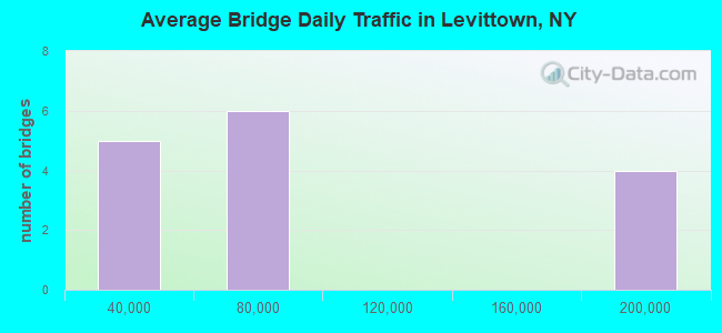
- 1,138,998Total average daily traffic
- 13,424Total average daily truck traffic
- National Bridge Inventory (NBI) Registered Bridges for Levittown
- No street view available for this location
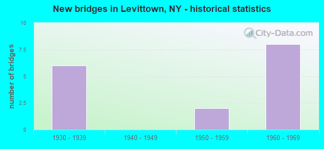
- New bridges - historical statistics
- 61930-1939
- 21950-1959
- 81960-1969
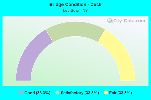
- Bridge Condition - Deck
- 33.3%Good
- 33.3%Satisfactory
- 33.3%Fair
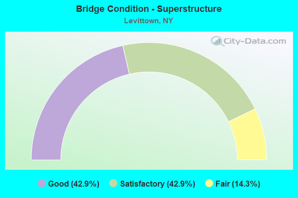
- Bridge Condition - Superstructure
- 42.9%Good
- 42.9%Satisfactory
- 14.3%Fair
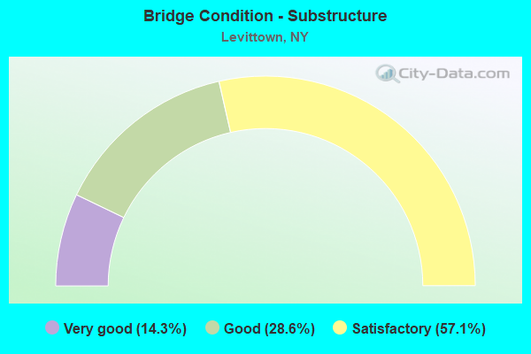
- Bridge Condition - Substructure
- 14.3%Very good
- 28.6%Good
- 57.1%Satisfactory
Find on map >> Show street view
Structure Number: 1036779, Location: JCT RTS 106+WSP (Lat: 40.728953, Lng: -73.540819), Route carried "on" structure: State highway 106, Year Built: 1938, Status: Open, Structure Length: 3.14m (10.30ft), Average Daily Traffic: 20,609 (year 2018), Truck Traffic: 4%, Average Future Daily Traffic: 23,778 (year 2040), Design Load: H 20, Features Intersected: 908T 908T 0301 1100, S/B
Minimum Vertical Clearance: 30+ m (98+ ft), Kilometerpoint: 4.312, Lanes on structure: 4, Lanes under structure: 4, Base Highway Network: Yes, Owner: State Highway Agency, Approaching Roadway Width: 9.8m (32.2ft), Skew: 24 degrees, Material/Design: Concrete continuous, Design/Construction: Frame, Number Of Spans In Main Unit: 2, Length of Maximum Span: 13.7m (44.9ft), Curb or Sidewalk Widths: Left: 1.8m (5.9ft), Right: 2.4m (7.9ft), Curb-To-Curb Width: 17.7m (58.1ft), Out-to-Out Width: 29.0m (95.1ft)
Condition: Deck: Fair, Superstructure: Fair, Substructure: Satisfactory, Operating Rating: 55.3 metric tons, Method Used To Determine Operating Rating: Load Factor (LF), Inventory Rating: 36.3 metric tons, Method Used To Determine Inventory Rating: Load Factor (LF), Structural Evaluation: Somewhat better than minimum adequacy, Deck Geometry: Somewhat better than minimum adequacy, Underclear: High priority of corrective action, Approach Roadway Alignment: Equal to present desirable criteria, Length Of Structure Improvement: 3.13m (10.27ft), Designated Inspection Frequency: Every 24 months, Inspection Date: June 2021, Bridge Improvement Cost: $5,240,000, Roadway Improvement Cost: $3,069,000, Total Project Cost: $8,309,000 ( Estimate for 2021), Deck Structure Type: Concrete Cast-file-Place, Wearing Surface/Protective System: Wearing Surface: Bituminous, Membrane: Preformed Fabric
Find on map >> Show street view
Structure Number: 1037819, Location: JCT RTS 135+SSP (Lat: 40.701025, Lng: -73.490356), Route carried "on" structure: State highway 135, Year Built: 1966, Status: Open, Structure Length: 2.44m (8.01ft), Average Daily Traffic: 72,320 (year 2018), Truck Traffic: 6%, Average Future Daily Traffic: 86,024 (year 2040), Design Load: HS 20, Features Intersected: RTE 908M
Minimum Vertical Clearance: 30+ m (98+ ft), Kilometerpoint: 4.039, Lanes on structure: 8, Lanes under structure: 4, Base Highway Network: Yes, Owner: State Highway Agency, Approaching Roadway Width: 32.9m (107.9ft), Skew: 22 degrees, Material/Design: Concrete, Design/Construction: Frame, Number Of Spans In Main Unit: 1, Length of Maximum Span: 23.1m (75.8ft), Curb-To-Curb Width: 33.0m (108.3ft), Out-to-Out Width: 37.0m (121.4ft)
Condition: Superstructure: Satisfactory, Substructure: Satisfactory, Operating Rating: 89.8 metric tons, Method Used To Determine Operating Rating: Load Factor (LF), Inventory Rating: 59.9 metric tons, Method Used To Determine Inventory Rating: Load Factor (LF), Structural Evaluation: Equal to present minimum criteria, Deck Geometry: Meets minimum limits, Underclear: High priority of corrective action, Approach Roadway Alignment: Equal to present desirable criteria, Length Of Structure Improvement: 2.43m (7.97ft), Designated Inspection Frequency: Every 24 months, Inspection Date: July 2021, Bridge Improvement Cost: $5,591,000, Roadway Improvement Cost: $3,274,000, Total Project Cost: $8,864,000 ( Estimate for 2021)
Find on map >> Show street view
Structure Number: 1037839, Location: .6 MI N JCT SH 135 & SSP (Lat: 40.707992, Lng: -73.485808), Route carried "on" structure: State highway 135, Year Built: 1965, Status: Open, Structure Length: 1.71m (5.61ft), Average Daily Traffic: 72,320 (year 2018), Truck Traffic: 5%, Average Future Daily Traffic: 86,024 (year 2040), Design Load: H 20, Features Intersected: ARLINGTON DRIVE
Minimum Vertical Clearance: 30+ m (98+ ft), Kilometerpoint: 4.891, Lanes on structure: 6, Lanes under structure: 2, Base Highway Network: Yes, Owner: State Highway Agency, Approaching Roadway Width: 23.8m (78.1ft), Skew: 22 degrees, Material/Design: Steel, Design/Construction: Stringer/Multi-beam, Number Of Spans In Main Unit: 1, Length of Maximum Span: 16.4m (53.8ft), Curb-To-Curb Width: 23.8m (78.1ft), Out-to-Out Width: 29.0m (95.1ft)
Condition: Deck: Good, Superstructure: Good, Substructure: Satisfactory, Operating Rating: 73.5 metric tons, Method Used To Determine Operating Rating: Load Factor (LF), Inventory Rating: 43.5 metric tons, Method Used To Determine Inventory Rating: Load Factor (LF), Structural Evaluation: Equal to present minimum criteria, Deck Geometry: High priority of corrective action, Underclear: Somewhat better than minimum adequacy, Approach Roadway Alignment: Better than present minimum criteria, Length Of Structure Improvement: 1.70m (5.58ft), Designated Inspection Frequency: Every 24 months, Inspection Date: June 2021, Bridge Improvement Cost: $4,158,000, Roadway Improvement Cost: $2,435,000, Total Project Cost: $6,592,000 ( Estimate for 2021), Deck Structure Type: Concrete Cast-file-Place, Wearing Surface/Protective System: Wearing Surface: Bituminous, Membrane: Preformed Fabric
Find on map >> Show street view
Structure Number: 105768, Location: 0.1 MI W JCT SH 135 & SSP (Lat: 40.701308, Lng: -73.492481), Route carried "on" structure: County highway , Year Built: 1957, Status: Open, Structure Length: 2.26m (7.41ft), Average Daily Traffic: 2,883 (year 2020), Truck Traffic: 3%, Average Future Daily Traffic: 3,567 (year 2040), Features Intersected: RTE 908M, Facility Carried by Structure: SEAMANS NECK ROAD
Minimum Vertical Clearance: 30+ m (98+ ft), Kilometerpoint: 0.193, Lanes on structure: 2, Lanes under structure: 4, Owner: State Highway Agency, Approaching Roadway Width: 12.5m (41.0ft), Material/Design: Concrete, Design/Construction: Arch - Deck, Number Of Spans In Main Unit: 1, Length of Maximum Span: 21.0m (68.9ft), Curb or Sidewalk Widths: Left: 1.4m (4.6ft), Right: 1.4m (4.6ft), Curb-To-Curb Width: 12.5m (41.0ft), Out-to-Out Width: 17.1m (56.1ft)
Condition: Superstructure: Good, Substructure: Very good, Operating Rating: 87.5 metric tons, Method Used To Determine Operating Rating: Field evaluation and documented engineering judgment, Inventory Rating: 32.7 metric tons, Method Used To Determine Inventory Rating: Field evaluation and documented engineering judgment, Structural Evaluation: Better than present minimum criteria, Deck Geometry: Equal to present minimum criteria, Underclear: High priority of corrective action, Approach Roadway Alignment: Better than present minimum criteria, Length Of Structure Improvement: 2.25m (7.38ft), Designated Inspection Frequency: Every 24 months, Inspection Date: July 2021, Bridge Improvement Cost: $3,155,000, Roadway Improvement Cost: $1,847,000, Total Project Cost: $5,002,000 ( Estimate for 2021), Wearing Surface/Protective System: Wearing Surface: Bituminous
Find on map >> Show street view
Structure Number: 1057819, Location: JCT RTS 135+SSP (Lat: 40.701400, Lng: -73.490364), Route carried "on" structure: State highway 135, Year Built: 1966, Year Reconstructed: 1969, Status: Open, Structure Length: 2.53m (8.30ft), Average Daily Traffic: 72,320 (year 2018), Truck Traffic: 6%, Average Future Daily Traffic: 86,024 (year 2040), Design Load: HS 20, Features Intersected: RTE 908M
Minimum Vertical Clearance: 30+ m (98+ ft), Kilometerpoint: 4.039, Lanes on structure: 8, Lanes under structure: 4, Base Highway Network: Yes, Owner: State Highway Agency, Approaching Roadway Width: 34.3m (112.5ft), Skew: 22 degrees, Material/Design: Concrete, Design/Construction: Frame, Number Of Spans In Main Unit: 1, Length of Maximum Span: 21.6m (70.9ft), Curb-To-Curb Width: 34.3m (112.5ft), Out-to-Out Width: 36.3m (119.1ft)
Condition: Deck: Satisfactory, Superstructure: Satisfactory, Substructure: Good, Operating Rating: 89.8 metric tons, Method Used To Determine Operating Rating: Load Factor (LF), Inventory Rating: 35.4 metric tons, Method Used To Determine Inventory Rating: Load Factor (LF), Structural Evaluation: Equal to present minimum criteria, Deck Geometry: Somewhat better than minimum adequacy, Underclear: High priority of corrective action, Approach Roadway Alignment: Equal to present desirable criteria, Length Of Structure Improvement: 2.52m (8.27ft), Designated Inspection Frequency: Every 24 months, Inspection Date: April 2021, Bridge Improvement Cost: $5,642,000, Roadway Improvement Cost: $3,304,000, Total Project Cost: $8,946,000 ( Estimate for 2021), Wearing Surface/Protective System: Wearing Surface: Bituminous
Find on map >> Show street view
Structure Number: 105858, Location: .3 MI N JCT SH 106 & WSP (Lat: 40.733797, Lng: -73.542989), Route carried "on" structure: County highway , Year Built: 1938, Status: Open, Structure Length: 2.53m (8.30ft), Average Daily Traffic: 6,746 (year 2017), Truck Traffic: 2%, Average Future Daily Traffic: 9,444 (year 2037), Design Load: H 20, Features Intersected: 908T 908T03011104 NB, RT, Facility Carried by Structure: SALISBURY PARK DR
Minimum Vertical Clearance: 30+ m (98+ ft), Kilometerpoint: 4.199, Lanes on structure: 4, Lanes under structure: 4, Owner: State Highway Agency, Approaching Roadway Width: 12.2m (40.0ft), Skew: 21 degrees, Material/Design: Concrete, Design/Construction: Arch - Deck, Number Of Spans In Main Unit: 1, Length of Maximum Span: 22.8m (74.8ft), Curb or Sidewalk Widths: Left: 1.2m (3.9ft), Right: 1.5m (4.9ft), Curb-To-Curb Width: 12.2m (40.0ft), Out-to-Out Width: 16.2m (53.1ft)
Condition: Superstructure: Good, Substructure: Satisfactory, Operating Rating: 62.1 metric tons, Method Used To Determine Operating Rating: Field evaluation and documented engineering judgment, Inventory Rating: 23.9 metric tons, Method Used To Determine Inventory Rating: Field evaluation and documented engineering judgment, Structural Evaluation: Somewhat better than minimum adequacy, Deck Geometry: High priority of replacement, Underclear: High priority of corrective action, Approach Roadway Alignment: Equal to present desirable criteria, Length Of Structure Improvement: 2.52m (8.27ft), Designated Inspection Frequency: Every 24 months, Inspection Date: March 2021, Bridge Improvement Cost: $3,170,000, Roadway Improvement Cost: $1,857,000, Total Project Cost: $5,027,000 ( Estimate for 2021), Wearing Surface/Protective System: Wearing Surface: Bituminous, Membrane: Preformed Fabric
Find on map >> Show street view
Structure Number: 105968, Location: 0.1 MI W JCT SH 135 & SSP (Lat: 40.701006, Lng: -73.492503), Route carried "on" structure: County highway , Year Built: 1931, Status: Open, Structure Length: 1.95m (6.40ft), Average Daily Traffic: 2,883 (year 2020), Truck Traffic: 3%, Average Future Daily Traffic: 3,567 (year 2040), Features Intersected: RTE 908M, Facility Carried by Structure: SEAMANS NECK ROAD
Minimum Vertical Clearance: 30+ m (98+ ft), Kilometerpoint: 0.161, Lanes on structure: 2, Lanes under structure: 4, Owner: State Highway Agency, Approaching Roadway Width: 12.5m (41.0ft), Material/Design: Concrete, Design/Construction: Arch - Deck, Number Of Spans In Main Unit: 1, Length of Maximum Span: 17.3m (56.8ft), Curb or Sidewalk Widths: Left: 1.4m (4.6ft), Right: 1.4m (4.6ft), Curb-To-Curb Width: 12.5m (41.0ft), Out-to-Out Width: 17.1m (56.1ft)
Condition: Superstructure: Satisfactory, Substructure: Good, Operating Rating: 54.9 metric tons, Method Used To Determine Operating Rating: Field evaluation and documented engineering judgment, Inventory Rating: 20.0 metric tons, Method Used To Determine Inventory Rating: Field evaluation and documented engineering judgment, Structural Evaluation: Somewhat better than minimum adequacy, Deck Geometry: Equal to present minimum criteria, Underclear: High priority of corrective action, Approach Roadway Alignment: Better than present minimum criteria, Length Of Structure Improvement: 1.95m (6.40ft), Designated Inspection Frequency: Every 24 months, Inspection Date: June 2021, Bridge Improvement Cost: $2,663,000, Roadway Improvement Cost: $1,560,000, Total Project Cost: $4,223,000 ( Estimate for 2021), Wearing Surface/Protective System: Wearing Surface: Bituminous
Find on map >> Show street view
Structure Number: 1036779, Location: JCT RTS 106+WSP (Lat: 40.728953, Lng: -73.540819), Route carried "under" structure: State highway 908T, Year Built: 1938, Structure Length: 0. m, Average Daily Traffic: 63,859 (year 2002), Features Intersected: 908T 908T 0301 1100, S/B, Facility Carried by Structure: RTE 106
Minimum Vertical Clearance: 3.48m (11.42ft), Kilometerpoint: 15.849, Lanes on structure: 4, Lanes under structure: 2, Material/Design: Concrete continuous, Design/Construction: Frame, Length of Maximum Span: 13.7m (44.9ft)
Find on map >> Show street view
Structure Number: 1037819, Location: JCT RTS 135+SSP (Lat: 40.701025, Lng: -73.490356), Route carried "under" structure: State highway 908M, Year Built: 1966, Structure Length: 0. m, Average Daily Traffic: 173,716 (year 2002), Features Intersected: RTE 908M, Facility Carried by Structure: RTE 135
Minimum Vertical Clearance: 4.29m (14.07ft), Kilometerpoint: 21.705, Lanes on structure: 8, Lanes under structure: 4, Material/Design: Concrete, Design/Construction: Frame, Length of Maximum Span: 23.1m (75.8ft)
Find on map >> Show street view
Structure Number: 103782, Location: .3 MI N JCT RTS 135+SSP (Lat: 40.704772, Lng: -73.488283), Route carried "under" structure: State highway , Year Built: 1965, Structure Length: 0. m, Features Intersected: 135 135 03011039 NB, RTE, Facility Carried by Structure: PED BR N OF SSP
Minimum Vertical Clearance: 4.60m (15.09ft), Kilometerpoint: 4.843, Lanes under structure: 4, Material/Design: Steel, Design/Construction: Stringer/Multi-beam, Length of Maximum Span: 23.4m (76.8ft)
Find on map >> Show street view
Structure Number: 103782, Location: .3 MI N JCT RTS 135+SSP (Lat: 40.704772, Lng: -73.488283), Route carried "under" structure: State highway 135, Year Built: 1965, Structure Length: 0. m, Average Daily Traffic: 63,635 (year 2002), Features Intersected: 135 135 03011039 NB, RTE, Facility Carried by Structure: PED BR N OF SSP
Minimum Vertical Clearance: 4.57m (14.99ft), Kilometerpoint: 4.843, Lanes under structure: 3, Material/Design: Steel, Design/Construction: Stringer/Multi-beam, Length of Maximum Span: 23.4m (76.8ft)
Find on map >> Show street view
Structure Number: 1037839, Location: .6 MI N JCT SH 135 & SSP (Lat: 40.707992, Lng: -73.485808), Route carried "under" structure: Other road , Year Built: 1965, Structure Length: 0. m, Average Daily Traffic: 2,700 (year 2021), Features Intersected: ARLINGTON DRIVE, Facility Carried by Structure: RTE 135
Minimum Vertical Clearance: 4.39m (14.40ft), Kilometerpoint: 0.000, Lanes on structure: 6, Lanes under structure: 2, Material/Design: Steel, Design/Construction: Stringer/Multi-beam, Length of Maximum Span: 16.4m (53.8ft)
Find on map >> Show street view
Structure Number: 105768, Location: 0.1 MI W JCT SH 135 & SSP (Lat: 40.701308, Lng: -73.492481), Route carried "under" structure: State highway 908M, Year Built: 1957, Structure Length: 0. m, Average Daily Traffic: 173,716 (year 2002), Features Intersected: RTE 908M, Facility Carried by Structure: SEAMANS NECK ROAD
Minimum Vertical Clearance: 4.11m (13.48ft), Kilometerpoint: 21.528, Lanes on structure: 2, Lanes under structure: 4, Material/Design: Concrete, Design/Construction: Arch - Deck, Length of Maximum Span: 21.0m (68.9ft)
Find on map >> Show street view
Structure Number: 1057819, Location: JCT RTS 135+SSP (Lat: 40.701400, Lng: -73.490364), Route carried "under" structure: State highway 908M, Year Built: 1966, Structure Length: 0. m, Average Daily Traffic: 173,716 (year 2002), Features Intersected: RTE 908M, Facility Carried by Structure: RTE 135
Minimum Vertical Clearance: 4.17m (13.68ft), Kilometerpoint: 21.705, Lanes on structure: 8, Lanes under structure: 4, Material/Design: Concrete, Design/Construction: Frame, Length of Maximum Span: 21.6m (70.9ft)
Find on map >> Show street view
Structure Number: 105858, Location: .3 MI N JCT SH 106 & WSP (Lat: 40.733797, Lng: -73.542989), Route carried "under" structure: State highway 908T, Year Built: 1938, Structure Length: 0. m, Average Daily Traffic: 63,859 (year 2002), Features Intersected: 908T 908T03011104 NB, RT, Facility Carried by Structure: SALISBURY PARK DR
Minimum Vertical Clearance: 4.19m (13.75ft), Kilometerpoint: 16.428, Lanes on structure: 4, Lanes under structure: 2, Material/Design: Concrete, Design/Construction: Arch - Deck, Length of Maximum Span: 22.8m (74.8ft)
Find on map >> Show street view
Structure Number: 105968, Location: 0.1 MI W JCT SH 135 & SSP (Lat: 40.701006, Lng: -73.492503), Route carried "under" structure: State highway 908M, Year Built: 1931, Structure Length: 0. m, Average Daily Traffic: 173,716 (year 2002), Features Intersected: RTE 908M, Facility Carried by Structure: SEAMANS NECK ROAD
Minimum Vertical Clearance: 4.11m (13.48ft), Kilometerpoint: 21.528, Lanes on structure: 2, Lanes under structure: 4, Material/Design: Concrete, Design/Construction: Arch - Deck, Length of Maximum Span: 17.3m (56.8ft)