Bridge Statistics for Lewisboro, New York (NY)
Condition, Traffic, Stress, Structural Evaluation, Project Costs
- National Bridge Inventory (NBI) Statistics
- 11Number of bridges
- 135ft / 40.8mTotal length
- $28,781,000Total costs
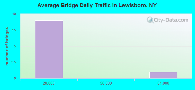
- 127,455Total average daily traffic
- 1,756Total average daily truck traffic
- National Bridge Inventory (NBI) Registered Bridges for Lewisboro
- No street view available for this location
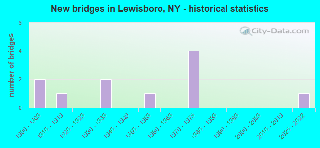
- New bridges - historical statistics
- 21900-1909
- 11910-1919
- 21930-1939
- 11950-1959
- 41970-1979
- 12020-2022
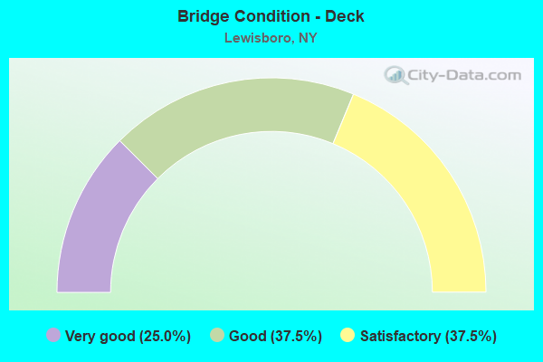
- Bridge Condition - Deck
- 25.0%Very good
- 37.5%Good
- 37.5%Satisfactory
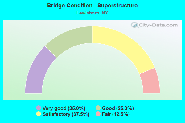
- Bridge Condition - Superstructure
- 25.0%Very good
- 25.0%Good
- 37.5%Satisfactory
- 12.5%Fair
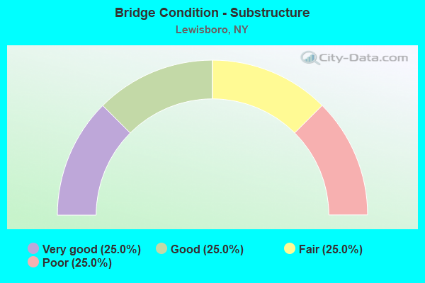
- Bridge Condition - Substructure
- 25.0%Very good
- 25.0%Good
- 25.0%Fair
- 25.0%Poor
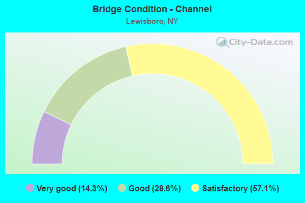
- Bridge Condition - Channel
- 14.3%Very good
- 28.6%Good
- 57.1%Satisfactory
Find on map >> Show street view
Structure Number: 102344, Location: JCT RTS 35+121 (Lat: 41.262603, Lng: -73.615278), Route carried "on" structure: State highway 35, Year Built: 1910, Status: Posted for load-capacity, Structure Length: 0.88m (2.89ft), Average Daily Traffic: 13,316 (year 2016), Truck Traffic: 3%, Average Future Daily Traffic: 16,176 (year 2040), Features Intersected: Trib. Cross River
Minimum Vertical Clearance: 30+ m (98+ ft), Kilometerpoint: 30.780, Lanes on structure: 2, Base Highway Network: Yes, Owner: State Highway Agency, Approaching Roadway Width: 6.7m (22.0ft), Skew: 4 degrees, Material/Design: Concrete, Design/Construction: Arch - Deck, Number Of Spans In Main Unit: 1, Length of Maximum Span: 6.4m (21.0ft), Curb-To-Curb Width: 6.7m (22.0ft), Out-to-Out Width: 7.6m (24.9ft)
Condition: Deck: Good, Superstructure: Good, Substructure: Good, Channel: Satisfactory, Operating Rating: 52.1 metric tons, Method Used To Determine Operating Rating: Field evaluation and documented engineering judgment, Inventory Rating: 24.5 metric tons, Method Used To Determine Inventory Rating: Field evaluation and documented engineering judgment, Structural Evaluation: Equal to present minimum criteria, Deck Geometry: High priority of replacement, Waterway Adequacy: Meets minimum limits, Approach Roadway Alignment: Meets minimum limits, Length Of Structure Improvement: 0.88m (2.89ft), Designated Inspection Frequency: Every 24 months, Inspection Date: December 2020, Bridge Improvement Cost: $231,000, Roadway Improvement Cost: $135,000, Total Project Cost: $367,000 ( Estimate for 2021), Wearing Surface/Protective System: Wearing Surface: Bituminous
Find on map >> Show street view
Structure Number: 102345, Location: 3 MI S JCT SH 22 & SH 35 (Lat: 41.275236, Lng: -73.578322), Route carried "on" structure: State highway 35, Year Built: 1937, Status: Open, Structure Length: 0.98m (3.22ft), Average Daily Traffic: 13,338 (year 2015), Truck Traffic: 4%, Average Future Daily Traffic: 16,203 (year 2040), Design Load: H 20, Features Intersected: WACCABUC RIVER
Minimum Vertical Clearance: 30+ m (98+ ft), Kilometerpoint: 34.883, Lanes on structure: 2, Base Highway Network: Yes, Owner: State Highway Agency, Approaching Roadway Width: 10.4m (34.1ft), Skew: 5 degrees, Material/Design: Concrete continuous, Design/Construction: Culvert, Number Of Spans In Main Unit: 2, Length of Maximum Span: 4.3m (14.1ft), Curb-To-Curb Width: 12.8m (42.0ft), Out-to-Out Width: 13.7m (44.9ft)
Condition: Channel: Satisfactory, Culverts: Satisfactory, Operating Rating: 36.0 metric tons, Method Used To Determine Operating Rating: Load and Resistance Factor Rating (LRFR) rating reported by rating factor(RF) method using HL-93 loadings, Inventory Rating: 27.9 metric tons, Method Used To Determine Inventory Rating: Load and Resistance Factor Rating (LRFR) rating reported by rating factor(RF) method using HL-93 loadings, Structural Evaluation: Equal to present minimum criteria, Deck Geometry: Somewhat better than minimum adequacy, Waterway Adequacy: Superior to present desirable criteria, Approach Roadway Alignment: Equal to present desirable criteria, Length Of Structure Improvement: 0.97m (3.18ft), Designated Inspection Frequency: Every 24 months, Inspection Date: July 2020, Bridge Improvement Cost: $1,110,000, Roadway Improvement Cost: $650,000, Total Project Cost: $1,759,000 ( Estimate for 2021)
Find on map >> Show street view
Structure Number: 103742, Location: 4.6 MI N JCT RTS 121+22 (Lat: 41.261456, Lng: -73.614650), Route carried "on" structure: State highway 121, Year Built: 1906, Status: Open, Structure Length: 1.52m (4.99ft), Average Daily Traffic: 2,773 (year 2019), Truck Traffic: 6%, Average Future Daily Traffic: 3,368 (year 2040), Features Intersected: CROSS RIVER RESER
Minimum Vertical Clearance: 30+ m (98+ ft), Kilometerpoint: 7.434, Lanes on structure: 2, Base Highway Network: Yes, Owner: Local Agency, Maintenance Responsibility: State Highway Agency, Approaching Roadway Width: 7.9m (25.9ft), Material/Design: Concrete, Design/Construction: Arch - Deck, Number Of Spans In Main Unit: 1, Length of Maximum Span: 9.1m (29.9ft), Curb-To-Curb Width: 7.2m (23.6ft), Out-to-Out Width: 8.8m (28.9ft)
Condition: Deck: Good, Superstructure: Satisfactory, Substructure: Fair, Channel: Good, Operating Rating: 47.4 metric tons, Method Used To Determine Operating Rating: Field evaluation and documented engineering judgment, Inventory Rating: 21.4 metric tons, Method Used To Determine Inventory Rating: Field evaluation and documented engineering judgment, Structural Evaluation: Somewhat better than minimum adequacy, Deck Geometry: High priority of replacement, Waterway Adequacy: Somewhat better than minimum adequacy, Approach Roadway Alignment: Meets minimum limits, Length Of Structure Improvement: 1.52m (4.99ft), Designated Inspection Frequency: Every 24 months, Underwater Inspection Frequency: Every 60 months, Inspection Date: December 2020, Underwater Inspection Date: September 2019, Bridge Improvement Cost: $394,000, Roadway Improvement Cost: $231,000, Total Project Cost: $625,000 ( Estimate for 2021), Wearing Surface/Protective System: Wearing Surface: Bituminous
Find on map >> Show street view
Structure Number: 109544, Location: JCT.RTE 138 & I684 (Lat: 41.295131, Lng: -73.676986), Route carried "on" structure: State highway 138, Year Built: 1976, Status: Open, Structure Length: 12.53m (41.11ft), Average Daily Traffic: 7,800 (year 2016), Truck Traffic: 4%, Average Future Daily Traffic: 9,650 (year 2040), Design Load: HS 20, Features Intersected: 684I684I87011200 NB, PAR
Minimum Vertical Clearance: 30+ m (98+ ft), Kilometerpoint: 2.655, Lanes on structure: 3, Lanes under structure: 9, Base Highway Network: Yes, Owner: State Highway Agency, Approaching Roadway Width: 13.1m (43.0ft), Skew: 2 degrees, Material/Design: Steel, Design/Construction: Stringer/Multi-beam, Number Of Spans In Main Unit: 4, Length of Maximum Span: 38.4m (126.0ft), Curb or Sidewalk Widths: Left: 0.0m, Right: 1.8m (5.9ft), Curb-To-Curb Width: 12.8m (42.0ft), Out-to-Out Width: 15.2m (49.9ft)
Condition: Deck: Satisfactory, Superstructure: Satisfactory, Substructure: Poor, Operating Rating: 11.0 metric tons, Method Used To Determine Operating Rating: Load and Resistance Factor Rating (LRFR) rating reported by rating factor(RF) method using HL-93 loadings, Inventory Rating: 8.4 metric tons, Method Used To Determine Inventory Rating: Load and Resistance Factor Rating (LRFR) rating reported by rating factor(RF) method using HL-93 loadings, Structural Evaluation: High priority of corrective action, Deck Geometry: Meets minimum limits, Underclear: High priority of corrective action, Approach Roadway Alignment: Equal to present desirable criteria, Length Of Structure Improvement: 12.52m (41.08ft), Designated Inspection Frequency: Every 24 months, Inspection Date: September 2021, Bridge Improvement Cost: $7,144,000, Roadway Improvement Cost: $4,183,000, Total Project Cost: $11,327,000 ( Estimate for 2021), Deck Structure Type: Concrete Cast-file-Place, Wearing Surface/Protective System: Wearing Surface: Monolithic Concrete
Find on map >> Show street view
Structure Number: 109544A, Location: JCT SH 138 & I684 (Lat: 41.295306, Lng: -73.677517), Route carried "on" structure: Ramp Other road 138, Year Built: 1976, Status: Open, Structure Length: 18.29m (60.01ft), Average Daily Traffic: 7,800 (year 2016), Truck Traffic: 4%, Average Future Daily Traffic: 9,650 (year 2040), Design Load: HS 20, Features Intersected: ADJACENT TO 684I
Minimum Vertical Clearance: 30+ m (98+ ft), Kilometerpoint: 2.623, Lanes on structure: 1, Base Highway Network: Yes, Owner: State Highway Agency, Approaching Roadway Width: 7.3m (24.0ft), Material/Design: Steel, Design/Construction: Stringer/Multi-beam, Number Of Spans In Main Unit: 8, Length of Maximum Span: 27.1m (88.9ft), Curb-To-Curb Width: 6.4m (21.0ft), Out-to-Out Width: 7.4m (24.3ft)
Condition: Deck: Good, Superstructure: Good, Substructure: Poor, Operating Rating: 69.0 metric tons, Method Used To Determine Operating Rating: Load and Resistance Factor Rating (LRFR) rating reported by rating factor(RF) method using HL-93 loadings, Inventory Rating: 53.5 metric tons, Method Used To Determine Inventory Rating: Load and Resistance Factor Rating (LRFR) rating reported by rating factor(RF) method using HL-93 loadings, Structural Evaluation: Meets minimum limits, Deck Geometry: Somewhat better than minimum adequacy, Approach Roadway Alignment: Equal to present desirable criteria, Length Of Structure Improvement: 18.28m (59.97ft), Designated Inspection Frequency: Every 24 months, Critical Feature Inspection Frequency: Every 24 months, Inspection Date: August 2021, Critical Feature Inspection Date: August 2021, Bridge Improvement Cost: $4,789,000, Roadway Improvement Cost: $2,804,000, Total Project Cost: $7,593,000 ( Estimate for 2021), Deck Structure Type: Concrete Cast-file-Place, Wearing Surface/Protective System: Wearing Surface: Monolithic Concrete
Find on map >> Show street view
Structure Number: 225605, Location: AT BRONXVILLE (Lat: 40.936508, Lng: -73.836150), Route carried "on" structure: Other road , Year Built: 1952, Status: Open, Structure Length: 3.93m (12.89ft), Truck Traffic: 15%, Features Intersected: BRONX RIVER, Facility Carried by Structure: PARKWAY ROAD
Minimum Vertical Clearance: 30+ m (98+ ft), Kilometerpoint: 0.145, Lanes on structure: 2, Owner: Town or Township Highway Agency, Approaching Roadway Width: 9.1m (29.9ft), Skew: 5 degrees, Material/Design: Steel, Design/Construction: Stringer/Multi-beam, Number Of Spans In Main Unit: 2, Length of Maximum Span: 19.8m (65.0ft), Curb or Sidewalk Widths: Left: 1.1m (3.6ft), Right: 2.4m (7.9ft), Curb-To-Curb Width: 8.9m (29.2ft), Out-to-Out Width: 13.4m (44.0ft)
Condition: Deck: Satisfactory, Superstructure: Fair, Substructure: Fair, Channel: Satisfactory, Operating Rating: 17.8 metric tons, Method Used To Determine Operating Rating: Load and Resistance Factor Rating (LRFR) rating reported by rating factor(RF) method using HL-93 loadings, Inventory Rating: 13.9 metric tons, Method Used To Determine Inventory Rating: Load and Resistance Factor Rating (LRFR) rating reported by rating factor(RF) method using HL-93 loadings, Structural Evaluation: Meets minimum limits, Deck Geometry: Better than present minimum criteria, Waterway Adequacy: Meets minimum limits, Approach Roadway Alignment: Equal to present desirable criteria, Length Of Structure Improvement: 3.93m (12.89ft), Designated Inspection Frequency: Every 24 months, Inspection Date: March 2021, Bridge Improvement Cost: $3,555,000, Roadway Improvement Cost: $2,082,000, Total Project Cost: $5,637,000 ( Estimate for 2021), Deck Structure Type: Concrete Cast-file-Place, Wearing Surface/Protective System: Wearing Surface: Bituminous
Find on map >> Show street view
Structure Number: 226569, Location: 5.2 MI SE CROTON FALLS (Lat: 41.287542, Lng: -73.557147), Route carried "on" structure: Other road , Year Built: 1930, Status: Open, Structure Length: 0.67m (2.20ft), Average Daily Traffic: 120 (year 2017), Truck Traffic: 4%, Average Future Daily Traffic: 168 (year 2037), Features Intersected: TRUESDALE LAKE OUTLET, Facility Carried by Structure: INDIAN LANE
Minimum Vertical Clearance: 32.69m (107.25ft), Kilometerpoint: 0.177, Lanes on structure: 2, Owner: Town or Township Highway Agency, Approaching Roadway Width: 5.5m (18.0ft), Material/Design: Wood or Timber, Design/Construction: Slab, Number Of Spans In Main Unit: 1, Length of Maximum Span: 6.4m (21.0ft), Curb-To-Curb Width: 5.5m (18.0ft), Out-to-Out Width: 5.9m (19.4ft)
Condition: Deck: Satisfactory, Superstructure: Satisfactory, Substructure: Good, Channel: Good, Operating Rating: 42.6 metric tons, Method Used To Determine Operating Rating: Allowable Stress (AS), Inventory Rating: 29.0 metric tons, Method Used To Determine Inventory Rating: Allowable Stress (AS), Structural Evaluation: Equal to present minimum criteria, Deck Geometry: High priority of corrective action, Waterway Adequacy: Somewhat better than minimum adequacy, Approach Roadway Alignment: Somewhat better than minimum adequacy, Length Of Structure Improvement: 0.67m (2.20ft), Designated Inspection Frequency: Every 24 months, Inspection Date: March 2021, Bridge Improvement Cost: $116,000, Roadway Improvement Cost: $68,000, Total Project Cost: $184,000 ( Estimate for 2021), Wearing Surface/Protective System: Wearing Surface: Bituminous
Find on map >> Show street view
Structure Number: 334852, Location: 12.0 MI.E.OF MT.KISCO (Lat: 41.221817, Lng: -73.496100), Route carried "on" structure: Other road , Year Built: 1909, Year Reconstructed: 2002, Status: Open, Structure Length: 1.19m (3.90ft), Average Daily Traffic: 172 (year 2019), Truck Traffic: 4%, Average Future Daily Traffic: 241 (year 2039), Design Load: HS 25 or greater, Features Intersected: NORWALK RESERVOIR, Facility Carried by Structure: EAST STREET
Minimum Vertical Clearance: 30+ m (98+ ft), Kilometerpoint: 3.073, Lanes on structure: 1, Owner: County Highway Agency, Approaching Roadway Width: 5.5m (18.0ft), Material/Design: Prestressed concrete, Design/Construction: Box Beam or Girders - Multiple, Number Of Spans In Main Unit: 1, Length of Maximum Span: 11.2m (36.7ft), Curb-To-Curb Width: 5.3m (17.4ft), Out-to-Out Width: 6.3m (20.7ft)
Condition: Deck: Very good, Superstructure: Very good, Substructure: Very good, Channel: Very good, Operating Rating: 47.0 metric tons, Method Used To Determine Operating Rating: Load and Resistance Factor Rating (LRFR) rating reported by rating factor(RF) method using HL-93 loadings, Inventory Rating: 36.3 metric tons, Method Used To Determine Inventory Rating: Load and Resistance Factor Rating (LRFR) rating reported by rating factor(RF) method using HL-93 loadings, Structural Evaluation: Equal to present desirable criteria, Deck Geometry: High priority of replacement, Waterway Adequacy: Somewhat better than minimum adequacy, Approach Roadway Alignment: Equal to present desirable criteria, Length Of Structure Improvement: 1.18m (3.87ft), Designated Inspection Frequency: Every 24 months, Underwater Inspection Frequency: Every 60 months, Inspection Date: April 2021, Underwater Inspection Date: September 2018, Bridge Improvement Cost: $626,000, Roadway Improvement Cost: $367,000, Total Project Cost: $992,000 ( Estimate for 2021), Deck Structure Type: Concrete Cast-file-Place, Wearing Surface/Protective System: Wearing Surface: Monolithic Concrete, Deck Protection: Epoxy Coated Reinforcing
Find on map >> Show street view
Structure Number: 336497, Location: 6.5 MI SE CROTON FALLS (Lat: 41.260294, Lng: -73.601983), Route carried "on" structure: Other road , Year Built: 2020, Status: Open, Structure Length: 0.79m (2.59ft), Average Daily Traffic: 240 (year 2009), Truck Traffic: 10%, Average Future Daily Traffic: 336 (year 2029), Features Intersected: CROSS RIVER, Facility Carried by Structure: STONE HILL ROAD
Minimum Vertical Clearance: 4.39m (14.40ft), Kilometerpoint: 0.000, Lanes on structure: 1, Owner: County Highway Agency, Approaching Roadway Width: 3.7m (12.1ft), Material/Design: Wood or Timber, Design/Construction: Stringer/Multi-beam, Number Of Spans In Main Unit: 1, Length of Maximum Span: 7.6m (24.9ft), Curb-To-Curb Width: 3.7m (12.1ft), Out-to-Out Width: 4.3m (14.1ft)
Condition: Deck: Very good, Superstructure: Very good, Substructure: Very good, Channel: Satisfactory, Operating Rating: 20.9 metric tons, Method Used To Determine Operating Rating: Allowable Stress (AS), Inventory Rating: 14.5 metric tons, Method Used To Determine Inventory Rating: Allowable Stress (AS), Structural Evaluation: Meets minimum limits, Deck Geometry: High priority of replacement, Waterway Adequacy: Meets minimum limits, Approach Roadway Alignment: Meets minimum limits, Length Of Structure Improvement: 0.79m (2.59ft), Designated Inspection Frequency: Every 24 months, Inspection Date: August 2020, Bridge Improvement Cost: $188,000, Roadway Improvement Cost: $110,000, Total Project Cost: $297,000 ( Estimate for 2021), Deck Structure Type: Wood or Timber, Wearing Surface/Protective System: Wearing Surface: Wood or Timber
Find on map >> Show street view
Structure Number: 109544, Location: JCT.RTE 138 & I684 (Lat: 41.295131, Lng: -73.676986), Route carried "under" structure: State highway 22, Year Built: 1976, Structure Length: 0. m, Average Daily Traffic: 3,987 (year 1999), Features Intersected: 684I684I87011200 NB, PAR, Facility Carried by Structure: RTE 138
Minimum Vertical Clearance: 8.99m (29.49ft), Kilometerpoint: 34.352, Lanes on structure: 3, Lanes under structure: 2, Material/Design: Steel, Design/Construction: Stringer/Multi-beam, Length of Maximum Span: 38.4m (126.0ft)
Find on map >> Show street view
Structure Number: 109544, Location: JCT.RTE 138 & I684 (Lat: 41.295131, Lng: -73.676986), Route carried "under" structure: Interstate 684, Year Built: 1976, Structure Length: 0. m, Average Daily Traffic: 77,909 (year 2002), Features Intersected: 684I684I87011200 NB, PAR, Facility Carried by Structure: RTE 138
Minimum Vertical Clearance: 8.46m (27.76ft), Kilometerpoint: 32.019, Lanes on structure: 3, Lanes under structure: 3, Material/Design: Steel, Design/Construction: Stringer/Multi-beam, Length of Maximum Span: 38.4m (126.0ft)