Bridge Statistics for Lewisville, Arkansas (AR)
Condition, Traffic, Stress, Structural Evaluation, Project Costs
- National Bridge Inventory (NBI) Statistics
- 11Number of bridges
- 82ft / 25.4mTotal length
- $2,176,000Total costs
- 29,627Total average daily traffic
- 5,709Total average daily truck traffic
- 40,646Total future (year 2007) average daily traffic
- National Bridge Inventory (NBI) Registered Bridges for Lewisville
- No street view available for this location
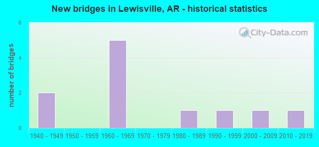
- New bridges - historical statistics
- 21940-1949
- 51960-1969
- 11980-1989
- 11990-1999
- 12000-2009
- 12010-2019


- Bridge Condition - Deck
- 20.0%Very good
- 20.0%Good
- 60.0%Satisfactory

- Bridge Condition - Superstructure
- 20.0%Very good
- 20.0%Good
- 60.0%Satisfactory

- Bridge Condition - Substructure
- 40.0%Very good
- 20.0%Good
- 40.0%Satisfactory

- Bridge Condition - Channel
- 9.1%Very good
- 45.5%Good
- 45.5%Satisfactory

- Bridge Condition - Culverts
- 83.3%Good
- 16.7%Satisfactory
Find on map >> Show street view
Structure Number: 3894, Location: 3.76 MI E MILLER CO L (Lat: 33.357783, Lng: -93.637297), Route carried "on" structure: US 82, Year Built: 1966, Status: Open, Structure Length: 2.56m (8.40ft), Average Daily Traffic: 4,000 (year 2018), Truck Traffic: 27%, Average Future Daily Traffic: 4,950 (year 2028), Design Load: HS 20, Features Intersected: DRAINAGE DITCH
Minimum Vertical Clearance: 30+ m (98+ ft), Kilometerpoint: 6.051, Lanes on structure: 2, Owner: State Highway Agency, Approaching Roadway Width: 11.6m (38.1ft), Material/Design: Concrete, Design/Construction: Slab, Number Of Spans In Main Unit: 3, Length of Maximum Span: 8.5m (27.9ft), Curb or Sidewalk Widths: Left: 0.5m (1.6ft), Right: 0.5m (1.6ft), Curb-To-Curb Width: 8.5m (27.9ft), Out-to-Out Width: 10.2m (33.5ft)
Condition: Deck: Satisfactory, Superstructure: Satisfactory, Substructure: Very good, Channel: Good, Operating Rating: 54.4 metric tons, Method Used To Determine Operating Rating: Load Factor (LF), Inventory Rating: 32.7 metric tons, Method Used To Determine Inventory Rating: Load Factor (LF), Structural Evaluation: Equal to present minimum criteria, Deck Geometry: Meets minimum limits, Waterway Adequacy: Better than present minimum criteria, Approach Roadway Alignment: Equal to present desirable criteria, Length Of Structure Improvement: 3.35m (10.99ft), Designated Inspection Frequency: Every 24 months, Critical Feature Inspection Frequency: Every 24 months, Inspection Date: January 2021, Roadway Improvement Cost: $400,000, Total Project Cost: $888,000, Deck Structure Type: Concrete Cast-file-Place, Wearing Surface/Protective System: Wearing Surface: Bituminous
Find on map >> Show street view
Structure Number: 3895, Location: 4.32 M E OF CO LINE (Lat: 33.358181, Lng: -93.633181), Route carried "on" structure: US 82, Year Built: 1966, Status: Open, Structure Length: 5.97m (19.59ft), Average Daily Traffic: 4,000 (year 2018), Truck Traffic: 27%, Average Future Daily Traffic: 4,950 (year 2028), Design Load: HS 20, Features Intersected: FIELD BAYOU
Minimum Vertical Clearance: 30+ m (98+ ft), Kilometerpoint: 6.453, Lanes on structure: 2, Owner: State Highway Agency, Approaching Roadway Width: 11.6m (38.1ft), Material/Design: Concrete, Design/Construction: Slab, Number Of Spans In Main Unit: 7, Length of Maximum Span: 8.5m (27.9ft), Curb or Sidewalk Widths: Left: 0.5m (1.6ft), Right: 0.5m (1.6ft), Curb-To-Curb Width: 8.6m (28.2ft), Out-to-Out Width: 10.3m (33.8ft)
Condition: Deck: Satisfactory, Superstructure: Satisfactory, Substructure: Satisfactory, Channel: Good, Operating Rating: 54.4 metric tons, Method Used To Determine Operating Rating: Load Factor (LF), Inventory Rating: 32.7 metric tons, Method Used To Determine Inventory Rating: Load Factor (LF), Structural Evaluation: Equal to present minimum criteria, Deck Geometry: Meets minimum limits, Waterway Adequacy: Better than present minimum criteria, Approach Roadway Alignment: Equal to present desirable criteria, Length Of Structure Improvement: 6.95m (22.80ft), Designated Inspection Frequency: Every 24 months, Critical Feature Inspection Frequency: Every 24 months, Inspection Date: January 2021, Roadway Improvement Cost: $400,000, Total Project Cost: $1,288,000, Deck Structure Type: Concrete Cast-file-Place, Wearing Surface/Protective System: Wearing Surface: Bituminous
Find on map >> Show street view
Structure Number: 4918, Location: 1.2 MILES E JCT 20 & 5 (Lat: 33.335569, Lng: -93.633669), Route carried "on" structure: County highway 20, Year Built: 2013, Status: Open, Structure Length: 3.66m (12.01ft), Average Daily Traffic: 265 (year 2018), Truck Traffic: 3%, Average Future Daily Traffic: 130 (year 2013), Design Load: HL 93, Features Intersected: FIELD BAYOU DITCH
Minimum Vertical Clearance: 30+ m (98+ ft), Kilometerpoint: 6.341, Lanes on structure: 2, Owner: County Highway Agency, Approaching Roadway Width: 7.3m (24.0ft), Skew: 2 degrees, Material/Design: Steel continuous, Design/Construction: Stringer/Multi-beam, Number Of Spans In Main Unit: 3, Length of Maximum Span: 12.2m (40.0ft), Curb-To-Curb Width: 7.3m (24.0ft), Out-to-Out Width: 8.3m (27.2ft)
Condition: Deck: Very good, Superstructure: Very good, Substructure: Very good, Channel: Very good, Operating Rating: 54.4 metric tons, Method Used To Determine Operating Rating: Load Factor (LF), Inventory Rating: 32.7 metric tons, Method Used To Determine Inventory Rating: Load Factor (LF), Structural Evaluation: Equal to present desirable criteria, Deck Geometry: Somewhat better than minimum adequacy, Waterway Adequacy: Better than present minimum criteria, Approach Roadway Alignment: Better than present minimum criteria, Designated Inspection Frequency: Every 24 months, Critical Feature Inspection Frequency: Every 24 months, Inspection Date: September 2021, Deck Structure Type: Concrete Cast-file-Place, Wearing Surface/Protective System: Wearing Surface: Monolithic Concrete
Find on map >> Show street view
Structure Number: 6928, Location: .25 MI. S. OF JCT.U.S. 82 (Lat: 33.352206, Lng: -93.576681), Route carried "on" structure: State highway 29, Year Built: 2004, Status: Open, Structure Length: 4.18m (13.71ft), Average Daily Traffic: 2,367 (year 2018), Truck Traffic: 13%, Average Future Daily Traffic: 6,037 (year 2028), Design Load: HS 20, Features Intersected: STEEL CREEK
Minimum Vertical Clearance: 30+ m (98+ ft), Kilometerpoint: 38.447, Lanes on structure: 2, Owner: State Highway Agency, Approaching Roadway Width: 12.2m (40.0ft), Skew: 2 degrees, Material/Design: Steel continuous, Design/Construction: Stringer/Multi-beam, Number Of Spans In Main Unit: 3, Length of Maximum Span: 13.7m (44.9ft), Curb-To-Curb Width: 12.2m (40.0ft), Out-to-Out Width: 13.2m (43.3ft)
Condition: Deck: Good, Superstructure: Good, Substructure: Good, Channel: Good, Operating Rating: 54.4 metric tons, Method Used To Determine Operating Rating: Load Factor (LF), Inventory Rating: 32.7 metric tons, Method Used To Determine Inventory Rating: Load Factor (LF), Structural Evaluation: Better than present minimum criteria, Deck Geometry: Equal to present minimum criteria, Waterway Adequacy: Superior to present desirable criteria, Approach Roadway Alignment: Equal to present desirable criteria, Designated Inspection Frequency: Every 24 months, Critical Feature Inspection Frequency: Every 24 months, Inspection Date: January 2022, Deck Structure Type: Concrete Cast-file-Place, Wearing Surface/Protective System: Wearing Surface: Monolithic Concrete, Deck Protection: Epoxy Coated Reinforcing
Find on map >> Show street view
Structure Number: 19237, Location: 0.1MI E OF WALNUT ST (Lat: 33.360133, Lng: -93.572967), Route carried "on" structure: City street 64530, Year Built: 1946, Status: Open, Structure Length: 0.98m (3.22ft), Average Daily Traffic: 1,100 (year 2018), Truck Traffic: 4%, Average Future Daily Traffic: 1,986 (year 2007), Design Load: H 15, Features Intersected: BATTLE CREEK (CITY), Facility Carried by Structure: EAST 6TH STREET
Minimum Vertical Clearance: 30+ m (98+ ft), Kilometerpoint: 0.322, Lanes on structure: 2, Owner: City or Municipal Highway Agency, Approaching Roadway Width: 7.0m (23.0ft), Material/Design: Concrete, Design/Construction: Culvert, Number Of Spans In Main Unit: 3, Length of Maximum Span: 3.0m (9.8ft)
Condition: Channel: Satisfactory, Culverts: Good, Operating Rating: 29.9 metric tons, Method Used To Determine Operating Rating: Load Factor (LF), Inventory Rating: 18.1 metric tons, Method Used To Determine Inventory Rating: Load Factor (LF), Structural Evaluation: Somewhat better than minimum adequacy, Waterway Adequacy: Equal to present minimum criteria, Approach Roadway Alignment: Better than present minimum criteria, Designated Inspection Frequency: Every 24 months, Critical Feature Inspection Frequency: Every 24 months, Inspection Date: January 2022
Find on map >> Show street view
Structure Number: 19751, Location: 3.94 MI W JCT 13&SH 29 (Lat: 33.407714, Lng: -93.628839), Route carried "on" structure: County highway 13, Year Built: 1980, Status: Open, Structure Length: 1.07m (3.51ft), Average Daily Traffic: 120 (year 2018), Truck Traffic: 5%, Average Future Daily Traffic: 31 (year 2007), Features Intersected: KENNY CREEK
Minimum Vertical Clearance: 30+ m (98+ ft), Kilometerpoint: 6.341, Lanes on structure: 2, Owner: County Highway Agency, Approaching Roadway Width: 10.7m (35.1ft), Material/Design: Concrete, Design/Construction: Culvert, Number Of Spans In Main Unit: 4, Length of Maximum Span: 2.4m (7.9ft)
Condition: Channel: Satisfactory, Culverts: Good, Operating Rating: 54.4 metric tons, Method Used To Determine Operating Rating: Load Factor (LF), Inventory Rating: 32.7 metric tons, Method Used To Determine Inventory Rating: Load Factor (LF), Structural Evaluation: Better than present minimum criteria, Waterway Adequacy: Equal to present desirable criteria, Approach Roadway Alignment: Equal to present desirable criteria, Designated Inspection Frequency: Every 24 months, Critical Feature Inspection Frequency: Every 24 months, Inspection Date: January 2022
Find on map >> Show street view
Structure Number: 21969, Location: .10 MI E JCT SH 313 (Lat: 33.349181, Lng: -93.572089), Route carried "on" structure: County highway 22, Year Built: 1998, Status: Posted for load, Structure Length: 2.71m (8.89ft), Average Daily Traffic: 75 (year 2018), Truck Traffic: 1%, Average Future Daily Traffic: 159 (year 2007), Features Intersected: CREEK
Minimum Vertical Clearance: 30+ m (98+ ft), Kilometerpoint: 8.224, Lanes on structure: 1, Owner: County Highway Agency, Approaching Roadway Width: 7.0m (23.0ft), Material/Design: Steel, Design/Construction: Orthotropic, Number Of Spans In Main Unit: 1, Length of Maximum Span: 26.8m (87.9ft), Curb-To-Curb Width: 5.3m (17.4ft), Out-to-Out Width: 5.5m (18.0ft)
Condition: Deck: Satisfactory, Superstructure: Satisfactory, Substructure: Satisfactory, Channel: Good, Operating Rating: 20.0 metric tons, Method Used To Determine Operating Rating: Load Factor (LF), Inventory Rating: 11.8 metric tons, Method Used To Determine Inventory Rating: Load Factor (LF), Structural Evaluation: Meets minimum limits, Deck Geometry: High priority of corrective action, Waterway Adequacy: Better than present minimum criteria, Approach Roadway Alignment: Better than present minimum criteria, Bridge Posting: Required (Relationship of Operating Rating to Maximum Legal Load: > 39.9% below), Designated Inspection Frequency: Every 24 months, Critical Feature Inspection Frequency: Every 24 months, Inspection Date: September 2021, Critical Feature Inspection Date: September 2021, Deck Structure Type: Steel plate, Wearing Surface/Protective System: Wearing Surface: Other
Find on map >> Show street view
Structure Number: M0712, Location: .5 M N OF US 82 (Lat: 33.367719, Lng: -93.577600), Route carried "on" structure: State highway 29, Year Built: 1946, Status: Open, Structure Length: 1.37m (4.49ft), Average Daily Traffic: 2,900 (year 2018), Truck Traffic: 13%, Average Future Daily Traffic: 5,554 (year 2028), Design Load: H 15, Features Intersected: WATERWAY
Minimum Vertical Clearance: 30+ m (98+ ft), Kilometerpoint: 0.821, Lanes on structure: 2, Owner: State Highway Agency, Approaching Roadway Width: 10.4m (34.1ft), Skew: 4 degrees, Material/Design: Concrete, Design/Construction: Culvert, Number Of Spans In Main Unit: 3, Length of Maximum Span: 4.3m (14.1ft)
Condition: Channel: Satisfactory, Culverts: Good, Operating Rating: 35.4 metric tons, Method Used To Determine Operating Rating: Load Factor (LF), Inventory Rating: 21.8 metric tons, Method Used To Determine Inventory Rating: Load Factor (LF), Structural Evaluation: Somewhat better than minimum adequacy, Waterway Adequacy: Equal to present minimum criteria, Approach Roadway Alignment: Equal to present desirable criteria, Designated Inspection Frequency: Every 24 months, Critical Feature Inspection Frequency: Every 24 months, Inspection Date: January 2021
Find on map >> Show street view
Structure Number: M1504, Location: 5.5 MI E OF MILLER CO L (Lat: 33.359417, Lng: -93.615656), Route carried "on" structure: US 82, Year Built: 1966, Status: Open, Structure Length: 0.79m (2.59ft), Average Daily Traffic: 4,000 (year 2018), Truck Traffic: 27%, Average Future Daily Traffic: 4,950 (year 2028), Features Intersected: RAWLS CREEK
Minimum Vertical Clearance: 30+ m (98+ ft), Kilometerpoint: 8.385, Lanes on structure: 3, Owner: State Highway Agency, Approaching Roadway Width: 15.2m (49.9ft), Material/Design: Concrete, Design/Construction: Culvert, Number Of Spans In Main Unit: 2, Length of Maximum Span: 3.7m (12.1ft)
Condition: Channel: Good, Culverts: Good, Operating Rating: 31.8 metric tons, Method Used To Determine Operating Rating: Load Factor (LF), Inventory Rating: 19.1 metric tons, Method Used To Determine Inventory Rating: Load Factor (LF), Structural Evaluation: Somewhat better than minimum adequacy, Waterway Adequacy: Better than present minimum criteria, Approach Roadway Alignment: Equal to present desirable criteria, Designated Inspection Frequency: Every 24 months, Critical Feature Inspection Frequency: Every 24 months, Inspection Date: January 2021
Find on map >> Show street view
Structure Number: X0039, Location: 0.2 MI E JCT SH 29 & 82 (Lat: 33.355192, Lng: -93.573786), Route carried "on" structure: US 82, Year Built: 1969, Status: Open, Structure Length: 1.19m (3.90ft), Average Daily Traffic: 5,400 (year 2018), Truck Traffic: 16%, Average Future Daily Traffic: 6,399 (year 2028), Design Load: H 20, Features Intersected: BATTLE CREEK
Minimum Vertical Clearance: 30+ m (98+ ft), Kilometerpoint: 12.054, Lanes on structure: 4, Owner: State Highway Agency, Approaching Roadway Width: 18.3m (60.0ft), Material/Design: Concrete, Design/Construction: Culvert, Number Of Spans In Main Unit: 3, Length of Maximum Span: 3.7m (12.1ft)
Condition: Channel: Satisfactory, Culverts: Good, Operating Rating: 31.8 metric tons, Method Used To Determine Operating Rating: Load Factor (LF), Inventory Rating: 19.1 metric tons, Method Used To Determine Inventory Rating: Load Factor (LF), Structural Evaluation: Meets minimum limits, Waterway Adequacy: Equal to present minimum criteria, Approach Roadway Alignment: Equal to present desirable criteria, Designated Inspection Frequency: Every 24 months, Critical Feature Inspection Frequency: Every 24 months, Inspection Date: January 2021
Find on map >> Show street view
Structure Number: X004, Location: 1.5 MI E JCT SH 29 & 82 (Lat: 33.362489, Lng: -93.550747), Route carried "on" structure: US 82, Year Built: 1969, Status: Open, Structure Length: 0.88m (2.89ft), Average Daily Traffic: 5,400 (year 2018), Truck Traffic: 16%, Average Future Daily Traffic: 5,500 (year 2038), Design Load: H 20, Features Intersected: WATERWAY
Minimum Vertical Clearance: 30+ m (98+ ft), Kilometerpoint: 14.436, Lanes on structure: 2, Owner: State Highway Agency, Approaching Roadway Width: 13.4m (44.0ft), Skew: 4 degrees, Material/Design: Concrete, Design/Construction: Culvert, Number Of Spans In Main Unit: 2, Length of Maximum Span: 4.3m (14.1ft)
Condition: Channel: Satisfactory, Culverts: Satisfactory, Operating Rating: 31.8 metric tons, Method Used To Determine Operating Rating: Load Factor (LF), Inventory Rating: 19.1 metric tons, Method Used To Determine Inventory Rating: Load Factor (LF), Structural Evaluation: Meets minimum limits, Waterway Adequacy: Equal to present minimum criteria, Approach Roadway Alignment: Equal to present desirable criteria, Designated Inspection Frequency: Every 24 months, Critical Feature Inspection Frequency: Every 24 months, Inspection Date: January 2021