Bridge Statistics for Lincoln, Iowa (IA)
Condition, Traffic, Stress, Structural Evaluation, Project Costs
- National Bridge Inventory (NBI) Statistics
- 15Number of bridges
- 66ft / 20.2mTotal length
- 1,095Total average daily traffic
- 117Total average daily truck traffic
- 1,095Total future (year 2038) average daily traffic
- National Bridge Inventory (NBI) Registered Bridges for Lincoln
- No street view available for this location
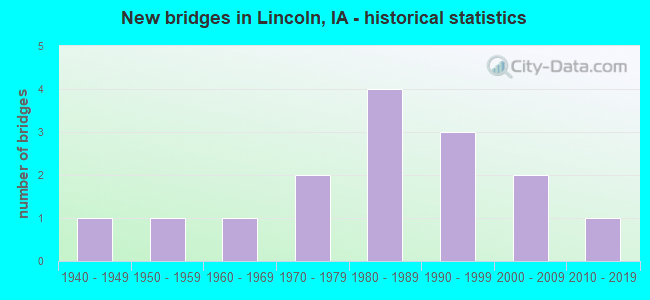
- New bridges - historical statistics
- 11940-1949
- 11950-1959
- 11960-1969
- 21970-1979
- 41980-1989
- 31990-1999
- 22000-2009
- 12010-2019

- Bridge Condition - Deck
- 28.6%Very good
- 28.6%Good
- 14.3%Satisfactory
- 28.6%Fair

- Bridge Condition - Superstructure
- 14.3%Very good
- 57.1%Good
- 14.3%Satisfactory
- 14.3%Fair

- Bridge Condition - Substructure
- 28.6%Very good
- 14.3%Good
- 14.3%Satisfactory
- 28.6%Fair
- 14.3%Poor

- Bridge Condition - Channel
- 6.7%Very good
- 26.7%Good
- 53.3%Satisfactory
- 13.3%Fair

- Bridge Condition - Culverts
- 12.5%Very good
- 37.5%Good
- 25.0%Poor
- 25.0%Serious
Find on map >> Show street view
Structure Number: 164281, Location: 087163302 (Lat: 42.299094, Lng: -92.728686), Route carried "on" structure: County highway , Year Built: 1983, Status: Open, Structure Length: 0.85m (2.79ft), Average Daily Traffic: 35 (year 2017), Average Future Daily Traffic: 35 (year 2040), Features Intersected: MOSQUITO CREEK, Facility Carried by Structure: LOCAL
Minimum Vertical Clearance: 30+ m (98+ ft), Kilometerpoint: 0.253, Lanes on structure: 2, Owner: County Highway Agency, Approaching Roadway Width: 6.1m (20.0ft), Material/Design: Wood or Timber, Design/Construction: Stringer/Multi-beam, Number Of Spans In Main Unit: 2, Length of Maximum Span: 4.3m (14.1ft), Curb-To-Curb Width: 7.3m (24.0ft), Out-to-Out Width: 7.3m (24.0ft)
Condition: Deck: Fair, Superstructure: Satisfactory, Substructure: Fair, Channel: Good, Operating Rating: 42.6 metric tons, Method Used To Determine Operating Rating: Allowable Stress (AS), Inventory Rating: 30.8 metric tons, Method Used To Determine Inventory Rating: Allowable Stress (AS), Structural Evaluation: Somewhat better than minimum adequacy, Deck Geometry: Equal to present minimum criteria, Waterway Adequacy: Better than present minimum criteria, Approach Roadway Alignment: Better than present minimum criteria, Length Of Structure Improvement: 4.80m (15.75ft), Designated Inspection Frequency: Every 24 months, Inspection Date: March 2020, Bridge Improvement Cost: $104,000, Roadway Improvement Cost: $10,000, Deck Structure Type: Wood or Timber, Wearing Surface/Protective System: Wearing Surface: Bituminous
Find on map >> Show street view
Structure Number: 164291, Location: 087163402 (Lat: 42.298653, Lng: -92.709267), Route carried "on" structure: County highway , Year Built: 1974, Status: Posted for load, Structure Length: 1.25m (4.10ft), Average Daily Traffic: 640 (year 2021), Truck Traffic: 17%, Average Future Daily Traffic: 640 (year 2041), Design Load: H 20, Features Intersected: MOSQUITO CREEK, Facility Carried by Structure: FM
Minimum Vertical Clearance: 30+ m (98+ ft), Kilometerpoint: 0.204, Lanes on structure: 2, Owner: County Highway Agency, Approaching Roadway Width: 6.7m (22.0ft), Material/Design: Steel, Design/Construction: Culvert, Number Of Spans In Main Unit: 2, Length of Maximum Span: 5.8m (19.0ft)
Condition: Channel: Satisfactory, Culverts: Serious, Operating Rating: 30.8 metric tons, Method Used To Determine Operating Rating: Field evaluation and documented engineering judgment, Inventory Rating: 22.7 metric tons, Method Used To Determine Inventory Rating: Field evaluation and documented engineering judgment, Structural Evaluation: High priority of corrective action, Waterway Adequacy: Somewhat better than minimum adequacy, Approach Roadway Alignment: Better than present minimum criteria, Bridge Posting: Required (Relationship of Operating Rating to Maximum Legal Load: 0.1 - 9.9% below), Length Of Structure Improvement: 6.30m (20.67ft), Designated Inspection Frequency: Every 12 months, Inspection Date: April 2021, Bridge Improvement Cost: $170,000, Roadway Improvement Cost: $17,000
Find on map >> Show street view
Structure Number: 164301, Location: 087163602 (Lat: 42.301417, Lng: -92.670433), Route carried "on" structure: County highway , Year Built: 1983, Status: Open, Structure Length: 3.14m (10.30ft), Average Daily Traffic: 40 (year 2017), Truck Traffic: 23%, Average Future Daily Traffic: 40 (year 2040), Design Load: H 20, Features Intersected: MOSQUITO CREEK, Facility Carried by Structure: FM
Minimum Vertical Clearance: 30+ m (98+ ft), Kilometerpoint: 0.499, Lanes on structure: 2, Owner: County Highway Agency, Approaching Roadway Width: 6.1m (20.0ft), Material/Design: Concrete continuous, Design/Construction: Slab, Number Of Spans In Main Unit: 3, Length of Maximum Span: 11.9m (39.0ft), Curb-To-Curb Width: 9.1m (29.9ft), Out-to-Out Width: 10.1m (33.1ft)
Condition: Deck: Good, Superstructure: Good, Substructure: Good, Channel: Good, Operating Rating: 49.9 metric tons, Method Used To Determine Operating Rating: Allowable Stress (AS), Inventory Rating: 30.8 metric tons, Method Used To Determine Inventory Rating: Allowable Stress (AS), Structural Evaluation: Better than present minimum criteria, Deck Geometry: Better than present minimum criteria, Waterway Adequacy: Equal to present desirable criteria, Approach Roadway Alignment: Better than present minimum criteria, Length Of Structure Improvement: 10.30m (33.79ft), Designated Inspection Frequency: Every 24 months, Inspection Date: March 2020, Bridge Improvement Cost: $15,000, Roadway Improvement Cost: $2,000, Deck Structure Type: Concrete Cast-file-Place, Wearing Surface/Protective System: Wearing Surface: Monolithic Concrete
Find on map >> Show street view
Structure Number: 320621, Location: 086153002 (Lat: 42.228044, Lng: -92.650750), Route carried "on" structure: County highway , Year Built: 1988, Status: Open, Structure Length: 0.82m (2.69ft), Average Daily Traffic: 10 (year 2017), Average Future Daily Traffic: 10 (year 2040), Features Intersected: FOUR MILE CREEK, Facility Carried by Structure: LOCAL
Minimum Vertical Clearance: 30+ m (98+ ft), Kilometerpoint: 26.781, Lanes on structure: 2, Owner: County Highway Agency, Approaching Roadway Width: 7.6m (24.9ft), Material/Design: Steel, Design/Construction: Culvert, Number Of Spans In Main Unit: 3, Length of Maximum Span: 2.4m (7.9ft)
Condition: Channel: Fair, Culverts: Poor, Operating Rating: 32.7 metric tons, Method Used To Determine Operating Rating: Load Factor (LF), Inventory Rating: 24.5 metric tons, Method Used To Determine Inventory Rating: Load Factor (LF), Structural Evaluation: Meets minimum limits, Waterway Adequacy: Better than present minimum criteria, Approach Roadway Alignment: Better than present minimum criteria, Length Of Structure Improvement: 2.70m (8.86ft), Designated Inspection Frequency: Every 24 months, Inspection Date: September 2020, Bridge Improvement Cost: $15,000, Roadway Improvement Cost: $2,000
Find on map >> Show street view
Structure Number: 320631, Location: 086153002 (Lat: 42.231158, Lng: -92.650767), Route carried "on" structure: County highway , Year Built: 1988, Status: Open, Structure Length: 1.22m (4.00ft), Average Daily Traffic: 10 (year 2017), Average Future Daily Traffic: 10 (year 2040), Features Intersected: FOUR MILE CREEK, Facility Carried by Structure: LOCAL
Minimum Vertical Clearance: 30+ m (98+ ft), Kilometerpoint: 27.127, Lanes on structure: 2, Owner: County Highway Agency, Approaching Roadway Width: 7.3m (24.0ft), Material/Design: Steel, Design/Construction: Stringer/Multi-beam, Number Of Spans In Main Unit: 1, Length of Maximum Span: 11.9m (39.0ft), Curb-To-Curb Width: 7.1m (23.3ft), Out-to-Out Width: 7.3m (24.0ft)
Condition: Deck: Satisfactory, Superstructure: Fair, Substructure: Fair, Channel: Satisfactory, Operating Rating: 42.0 metric tons, Method Used To Determine Operating Rating: Load Factor (LF), Inventory Rating: 25.1 metric tons, Method Used To Determine Inventory Rating: Load Factor (LF), Structural Evaluation: Somewhat better than minimum adequacy, Deck Geometry: Somewhat better than minimum adequacy, Waterway Adequacy: Better than present minimum criteria, Approach Roadway Alignment: Better than present minimum criteria, Length Of Structure Improvement: 4.00m (13.12ft), Designated Inspection Frequency: Every 24 months, Inspection Date: September 2020, Bridge Improvement Cost: $15,000, Roadway Improvement Cost: $2,000, Deck Structure Type: Wood or Timber, Wearing Surface/Protective System: Wearing Surface: Bituminous
Find on map >> Show street view
Structure Number: 320671, Location: 086160101 (Lat: 42.296894, Lng: -92.655789), Route carried "on" structure: County highway , Year Built: 2000, Status: Open, Structure Length: 1.22m (4.00ft), Average Daily Traffic: 35 (year 2017), Average Future Daily Traffic: 35 (year 2040), Design Load: HS 20, Features Intersected: BRANCH MOSQUITO CREEK, Facility Carried by Structure: LOCAL ROAD
Minimum Vertical Clearance: 30+ m (98+ ft), Kilometerpoint: 6.801, Lanes on structure: 2, Owner: County Highway Agency, Approaching Roadway Width: 6.7m (22.0ft), Material/Design: Steel, Design/Construction: Slab, Number Of Spans In Main Unit: 1, Length of Maximum Span: 11.6m (38.1ft), Curb-To-Curb Width: 7.5m (24.6ft), Out-to-Out Width: 7.6m (24.9ft)
Condition: Deck: Very good, Superstructure: Good, Substructure: Very good, Channel: Good, Operating Rating: 59.9 metric tons, Method Used To Determine Operating Rating: Load Factor (LF), Inventory Rating: 35.9 metric tons, Method Used To Determine Inventory Rating: Load Factor (LF), Structural Evaluation: Better than present minimum criteria, Deck Geometry: Equal to present minimum criteria, Waterway Adequacy: Equal to present desirable criteria, Approach Roadway Alignment: Better than present minimum criteria, Length Of Structure Improvement: 4.00m (13.12ft), Designated Inspection Frequency: Every 24 months, Inspection Date: September 2020, Bridge Improvement Cost: $15,000, Roadway Improvement Cost: $2,000, Deck Structure Type: Open Grating, Wearing Surface/Protective System: Wearing Surface: Other
Find on map >> Show street view
Structure Number: 320681, Location: 086160102 (Lat: 42.287472, Lng: -92.670547), Route carried "on" structure: County highway , Year Built: 2019, Status: Open, Structure Length: 0.82m (2.69ft), Average Daily Traffic: 50 (year 2017), Average Future Daily Traffic: 50 (year 2040), Features Intersected: BRANCH BLACK HAWK CREEK, Facility Carried by Structure: T53 F AVE
Minimum Vertical Clearance: 30+ m (98+ ft), Kilometerpoint: 42.973, Lanes on structure: 2, Owner: County Highway Agency, Approaching Roadway Width: 7.6m (24.9ft), Material/Design: Steel, Design/Construction: Culvert, Number Of Spans In Main Unit: 1, Length of Maximum Span: 3.4m (11.2ft)
Condition: Channel: Satisfactory, Culverts: Very good, Operating Rating: 44.1 metric tons, Method Used To Determine Operating Rating: Assigned rating based on Load Factor Design (LFD) reported in metric tons, Inventory Rating: 32.7 metric tons, Method Used To Determine Inventory Rating: Assigned rating based on Load Factor Design (LFD) reported in metric tons, Structural Evaluation: Equal to present desirable criteria, Waterway Adequacy: Equal to present minimum criteria, Approach Roadway Alignment: Somewhat better than minimum adequacy, Designated Inspection Frequency: Every 24 months, Inspection Date: September 2020
Find on map >> Show street view
Structure Number: 32073, Location: 086160704 (Lat: 42.279228, Lng: -92.757956), Route carried "on" structure: County highway , Year Built: 1955, Year Reconstructed: 2014, Status: Open, Structure Length: 1.74m (5.71ft), Average Daily Traffic: 50 (year 2021), Average Future Daily Traffic: 50 (year 2040), Design Load: H 15, Features Intersected: LITTLE WOLF CREEK, Facility Carried by Structure: FM
Minimum Vertical Clearance: 30+ m (98+ ft), Kilometerpoint: 12.783, Lanes on structure: 2, Owner: County Highway Agency, Approaching Roadway Width: 8.5m (27.9ft), Material/Design: Steel, Design/Construction: Stringer/Multi-beam, Number Of Spans In Main Unit: 1, Length of Maximum Span: 16.8m (55.1ft), Curb-To-Curb Width: 6.1m (20.0ft), Out-to-Out Width: 6.1m (20.0ft)
Condition: Deck: Fair, Superstructure: Good, Substructure: Satisfactory, Channel: Satisfactory, Operating Rating: 26.5 metric tons, Method Used To Determine Operating Rating: Load Factor (LF), Inventory Rating: 15.9 metric tons, Method Used To Determine Inventory Rating: Load Factor (LF), Structural Evaluation: Meets minimum limits, Deck Geometry: Somewhat better than minimum adequacy, Waterway Adequacy: Better than present minimum criteria, Approach Roadway Alignment: Better than present minimum criteria, Length Of Structure Improvement: 10.00m (32.81ft), Designated Inspection Frequency: Every 24 months, Inspection Date: September 2020, Bridge Improvement Cost: $228,000, Roadway Improvement Cost: $23,000, Deck Structure Type: Concrete Cast-file-Place, Wearing Surface/Protective System: Wearing Surface: Monolithic Concrete
Find on map >> Show street view
Structure Number: 320751, Location: 086161101 (Lat: 42.282614, Lng: -92.682872), Route carried "on" structure: County highway , Year Built: 1990, Status: Open, Structure Length: 0.79m (2.59ft), Average Daily Traffic: 10 (year 2017), Average Future Daily Traffic: 10 (year 2038), Features Intersected: DRAINAGE, Facility Carried by Structure: LOCAL
Minimum Vertical Clearance: 30+ m (98+ ft), Kilometerpoint: 7.010, Lanes on structure: 2, Owner: County Highway Agency, Approaching Roadway Width: 7.3m (24.0ft), Material/Design: Steel, Design/Construction: Culvert, Number Of Spans In Main Unit: 3, Length of Maximum Span: 2.4m (7.9ft)
Condition: Channel: Satisfactory, Culverts: Good, Operating Rating: 44.1 metric tons, Method Used To Determine Operating Rating: Assigned rating based on Load Factor Design (LFD) reported in metric tons, Inventory Rating: 32.7 metric tons, Method Used To Determine Inventory Rating: Assigned rating based on Load Factor Design (LFD) reported in metric tons, Structural Evaluation: Better than present minimum criteria, Waterway Adequacy: Better than present minimum criteria, Approach Roadway Alignment: Better than present minimum criteria, Length Of Structure Improvement: 2.60m (8.53ft), Designated Inspection Frequency: Every 48 months, Inspection Date: September 2018, Bridge Improvement Cost: $15,000, Roadway Improvement Cost: $2,000
Find on map >> Show street view
Structure Number: 320761, Location: 086161102 (Lat: 42.278331, Lng: -92.689917), Route carried "on" structure: County highway , Year Built: 1990, Status: Open, Structure Length: 0.70m (2.30ft), Average Daily Traffic: 40 (year 2017), Average Future Daily Traffic: 40 (year 2038), Features Intersected: DRAINAGE, Facility Carried by Structure: LOCAL
Minimum Vertical Clearance: 30+ m (98+ ft), Kilometerpoint: 32.940, Lanes on structure: 2, Owner: County Highway Agency, Approaching Roadway Width: 7.3m (24.0ft), Material/Design: Steel, Design/Construction: Culvert, Number Of Spans In Main Unit: 3, Length of Maximum Span: 2.1m (6.9ft)
Condition: Channel: Good, Culverts: Good, Operating Rating: 44.1 metric tons, Method Used To Determine Operating Rating: Assigned rating based on Load Factor Design (LFD) reported in metric tons, Inventory Rating: 32.7 metric tons, Method Used To Determine Inventory Rating: Assigned rating based on Load Factor Design (LFD) reported in metric tons, Structural Evaluation: Better than present minimum criteria, Waterway Adequacy: Better than present minimum criteria, Approach Roadway Alignment: Better than present minimum criteria, Length Of Structure Improvement: 2.30m (7.55ft), Designated Inspection Frequency: Every 48 months, Inspection Date: September 2018, Bridge Improvement Cost: $15,000, Roadway Improvement Cost: $2,000
Find on map >> Show street view
Structure Number: 320781, Location: 086161803 (Lat: 42.268083, Lng: -92.748772), Route carried "on" structure: County highway , Year Built: 1975, Status: Open, Structure Length: 2.38m (7.81ft), Average Daily Traffic: 50 (year 2017), Average Future Daily Traffic: 50 (year 2040), Design Load: H 20, Features Intersected: STREAM, Facility Carried by Structure: LOCAL
Minimum Vertical Clearance: 30+ m (98+ ft), Kilometerpoint: 1.574, Lanes on structure: 2, Owner: County Highway Agency, Approaching Roadway Width: 7.3m (24.0ft), Material/Design: Concrete continuous, Design/Construction: Slab, Number Of Spans In Main Unit: 3, Length of Maximum Span: 8.8m (28.9ft), Curb-To-Curb Width: 7.3m (24.0ft), Out-to-Out Width: 7.9m (25.9ft)
Condition: Deck: Good, Superstructure: Good, Substructure: Poor, Channel: Fair, Operating Rating: 37.0 metric tons, Method Used To Determine Operating Rating: Load Factor (LF), Inventory Rating: 22.1 metric tons, Method Used To Determine Inventory Rating: Load Factor (LF), Structural Evaluation: Meets minimum limits, Deck Geometry: Equal to present minimum criteria, Waterway Adequacy: Equal to present minimum criteria, Approach Roadway Alignment: Better than present minimum criteria, Length Of Structure Improvement: 7.50m (24.61ft), Designated Inspection Frequency: Every 24 months, Inspection Date: September 2020, Bridge Improvement Cost: $15,000, Roadway Improvement Cost: $2,000, Deck Structure Type: Concrete Cast-file-Place, Wearing Surface/Protective System: Wearing Surface: Monolithic Concrete
Find on map >> Show street view
Structure Number: 320791, Location: 086161903 (Lat: 42.253594, Lng: -92.750625), Route carried "on" structure: County highway , Year Built: 2003, Status: Open, Structure Length: 3.14m (10.30ft), Average Daily Traffic: 35 (year 2021), Average Future Daily Traffic: 35 (year 2038), Design Load: HS 20, Features Intersected: WOLF CREEK, Facility Carried by Structure: FM
Minimum Vertical Clearance: 30+ m (98+ ft), Kilometerpoint: 1.413, Lanes on structure: 2, Owner: County Highway Agency, Approaching Roadway Width: 8.5m (27.9ft), Skew: 1 degrees, Material/Design: Concrete continuous, Design/Construction: Slab, Number Of Spans In Main Unit: 3, Length of Maximum Span: 11.9m (39.0ft), Curb-To-Curb Width: 9.9m (32.5ft), Out-to-Out Width: 10.1m (33.1ft)
Condition: Deck: Very good, Superstructure: Very good, Substructure: Very good, Channel: Very good, Operating Rating: 80.4 metric tons, Method Used To Determine Operating Rating: Load Factor (LF), Inventory Rating: 48.2 metric tons, Method Used To Determine Inventory Rating: Load Factor (LF), Structural Evaluation: Equal to present desirable criteria, Deck Geometry: Superior to present desirable criteria, Waterway Adequacy: Equal to present desirable criteria, Approach Roadway Alignment: Equal to present desirable criteria, Length Of Structure Improvement: 10.00m (32.81ft), Designated Inspection Frequency: Every 48 months, Inspection Date: September 2018, Bridge Improvement Cost: $15,000, Roadway Improvement Cost: $2,000, Deck Structure Type: Concrete Cast-file-Place, Wearing Surface/Protective System: Wearing Surface: Monolithic Concrete
Find on map >> Show street view
Structure Number: 32082, Location: 086162502 (Lat: 42.238117, Lng: -92.670325), Route carried "on" structure: County highway , Year Built: 1963, Status: Open, Structure Length: 0.67m (2.20ft), Average Daily Traffic: 30 (year 2017), Average Future Daily Traffic: 30 (year 2041), Features Intersected: BRANCH WOLF CREEK, Facility Carried by Structure: LOCAL
Minimum Vertical Clearance: 30+ m (98+ ft), Kilometerpoint: 38.112, Lanes on structure: 2, Owner: County Highway Agency, Approaching Roadway Width: 8.5m (27.9ft), Material/Design: Wood or Timber, Design/Construction: Culvert, Number Of Spans In Main Unit: 4, Length of Maximum Span: 1.5m (4.9ft)
Condition: Channel: Satisfactory, Culverts: Serious, Operating Rating: 32.7 metric tons, Method Used To Determine Operating Rating: Field evaluation and documented engineering judgment, Inventory Rating: 20.0 metric tons, Method Used To Determine Inventory Rating: Field evaluation and documented engineering judgment, Structural Evaluation: High priority of corrective action, Waterway Adequacy: Equal to present minimum criteria, Approach Roadway Alignment: Better than present minimum criteria, Length Of Structure Improvement: 4.20m (13.78ft), Designated Inspection Frequency: Every 12 months, Inspection Date: September 2021, Bridge Improvement Cost: $96,000, Roadway Improvement Cost: $10,000
Find on map >> Show street view
Structure Number: 320861, Location: 086163601 (Lat: 42.224814, Lng: -92.652494), Route carried "on" structure: County highway , Year Built: 1990, Status: Open, Structure Length: 0.79m (2.59ft), Average Daily Traffic: 20 (year 2021), Average Future Daily Traffic: 20 (year 2038), Features Intersected: BR FOUR MILE CRK, Facility Carried by Structure: FM
Minimum Vertical Clearance: 30+ m (98+ ft), Kilometerpoint: 9.490, Lanes on structure: 2, Owner: County Highway Agency, Approaching Roadway Width: 7.9m (25.9ft), Skew: 1 degrees, Material/Design: Steel, Design/Construction: Culvert, Number Of Spans In Main Unit: 3, Length of Maximum Span: 2.4m (7.9ft)
Condition: Channel: Satisfactory, Culverts: Good, Operating Rating: 44.1 metric tons, Method Used To Determine Operating Rating: Assigned rating based on Load Factor Design (LFD) reported in metric tons, Inventory Rating: 32.7 metric tons, Method Used To Determine Inventory Rating: Assigned rating based on Load Factor Design (LFD) reported in metric tons, Structural Evaluation: Better than present minimum criteria, Waterway Adequacy: Better than present minimum criteria, Approach Roadway Alignment: Better than present minimum criteria, Length Of Structure Improvement: 2.60m (8.53ft), Designated Inspection Frequency: Every 48 months, Inspection Date: September 2018, Bridge Improvement Cost: $15,000, Roadway Improvement Cost: $2,000
Find on map >> Show street view
Structure Number: 36251, Location: 086162602 (Lat: 42.238986, Lng: -92.689553), Route carried "on" structure: County highway , Year Built: 1945, Status: Open, Structure Length: 0.70m (2.30ft), Average Daily Traffic: 40 (year 2017), Average Future Daily Traffic: 40 (year 2040), Features Intersected: BRANCH WOLF CREEK, Facility Carried by Structure: LOCAL
Minimum Vertical Clearance: 30+ m (98+ ft), Kilometerpoint: 29.762, Lanes on structure: 2, Owner: County Highway Agency, Approaching Roadway Width: 9.1m (29.9ft), Material/Design: Wood or Timber, Design/Construction: Culvert, Number Of Spans In Main Unit: 4, Length of Maximum Span: 1.5m (4.9ft)
Condition: Channel: Satisfactory, Culverts: Poor, Operating Rating: 18.0 metric tons, Method Used To Determine Operating Rating: Allowable Stress (AS), Inventory Rating: 13.0 metric tons, Method Used To Determine Inventory Rating: Allowable Stress (AS), Structural Evaluation: Meets minimum limits, Waterway Adequacy: Equal to present minimum criteria, Approach Roadway Alignment: Better than present minimum criteria, Length Of Structure Improvement: 2.30m (7.55ft), Designated Inspection Frequency: Every 24 months, Inspection Date: September 2020, Bridge Improvement Cost: $15,000, Roadway Improvement Cost: $2,000