Bridge Statistics for Lincoln Park, Michigan (MI)
Condition, Traffic, Stress, Structural Evaluation, Project Costs
- National Bridge Inventory (NBI) Statistics
- 40Number of bridges
- 466ft / 142mTotal length
- $209,000Total costs
- 1,274,721Total average daily traffic
- 120,273Total average daily truck traffic
- National Bridge Inventory (NBI) Registered Bridges for Lincoln Park
- No street view available for this location
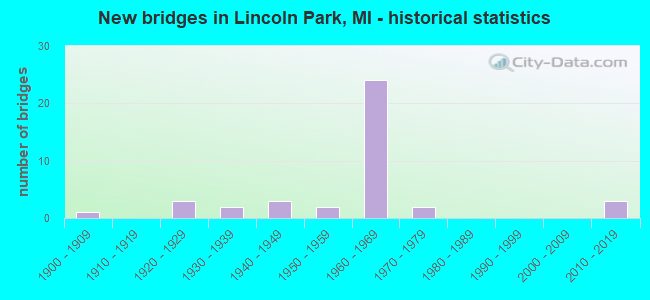
- New bridges - historical statistics
- 11900-1909
- 31920-1929
- 21930-1939
- 31940-1949
- 21950-1959
- 241960-1969
- 21970-1979
- 32010-2019
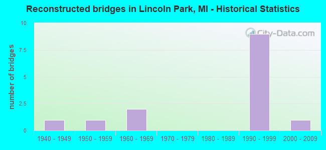
- Reconstructed bridges - Historical Statistics
- 11940-1949
- 11950-1959
- 21960-1969
- 01970-1979
- 01980-1989
- 91990-1999
- 12000-2009
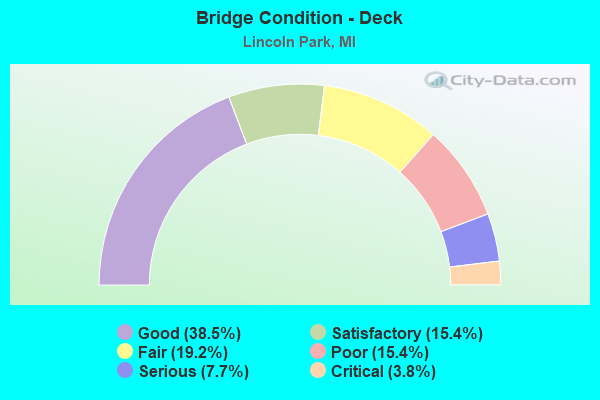
- Bridge Condition - Deck
- 38.5%Good
- 15.4%Satisfactory
- 19.2%Fair
- 15.4%Poor
- 7.7%Serious
- 3.8%Critical
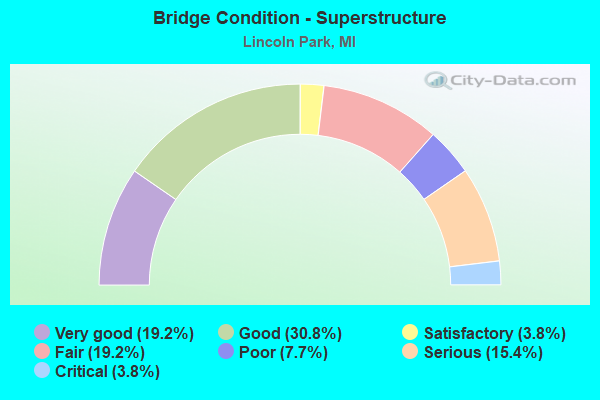
- Bridge Condition - Superstructure
- 19.2%Very good
- 30.8%Good
- 3.8%Satisfactory
- 19.2%Fair
- 7.7%Poor
- 15.4%Serious
- 3.8%Critical
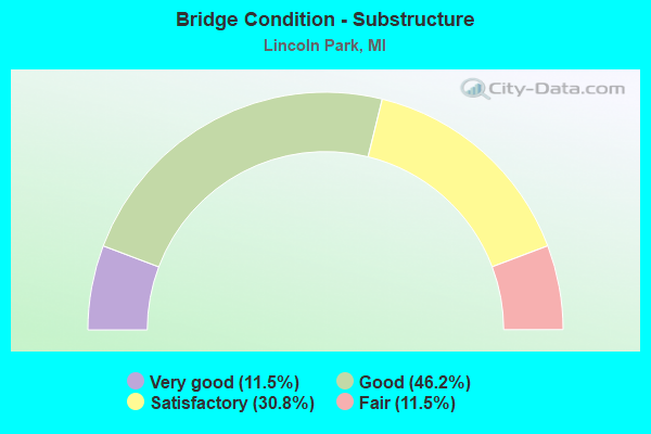
- Bridge Condition - Substructure
- 11.5%Very good
- 46.2%Good
- 30.8%Satisfactory
- 11.5%Fair
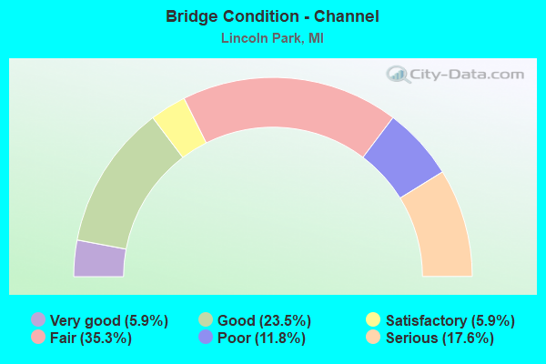
- Bridge Condition - Channel
- 5.9%Very good
- 23.5%Good
- 5.9%Satisfactory
- 35.3%Fair
- 11.8%Poor
- 17.6%Serious
Find on map >> Show street view
Structure Number: 117, Location: 1.5 MI S OF DOUGLAS (Lat: 42.623267, Lng: -86.211783), Route carried "on" structure: County highway 303, Year Built: 1964, Status: Open, Structure Length: 9.78m (32.09ft), Average Daily Traffic: 5,143 (year 1996), Truck Traffic: 28%, Average Future Daily Traffic: 8,500 (year 2016), Design Load: HS 20+Mod, Features Intersected: I-196 & US-31, Facility Carried by Structure: OLD US-31
Minimum Vertical Clearance: 30.48m (100.00ft), Kilometerpoint: 3.330, Lanes on structure: 2, Lanes under structure: 6, Owner: State Highway Agency, Approaching Roadway Width: 12.7m (41.7ft), Skew: 4 degrees, Material/Design: Steel, Design/Construction: Stringer/Multi-beam, Number Of Spans In Main Unit: 4, Length of Maximum Span: 33.5m (109.9ft), Curb-To-Curb Width: 14.0m (45.9ft), Out-to-Out Width: 15.1m (49.5ft)
Condition: Deck: Poor, Superstructure: Fair, Substructure: Fair, Operating Rating: 66.1 metric tons, Method Used To Determine Operating Rating: Load Factor (LF) rating reported by rating factor (RF) method using MS18 loading, Inventory Rating: 39.5 metric tons, Method Used To Determine Inventory Rating: Load Factor (LF) rating reported by rating factor (RF) method using MS18 loading, Structural Evaluation: Somewhat better than minimum adequacy, Deck Geometry: Superior to present desirable criteria, Underclear: Somewhat better than minimum adequacy, Approach Roadway Alignment: Equal to present desirable criteria, Designated Inspection Frequency: Every 12 months, Inspection Date: May 2021, Bridge Improvement Cost: $436,000, Deck Structure Type: Concrete Cast-file-Place, Wearing Surface/Protective System: Wearing Surface: Latex Concrete
Find on map >> Show street view
Structure Number: 1179, Location: UNION TWP SEC 10-15 (Lat: 42.043289, Lng: -85.116192), Route carried "on" structure: County highway , Year Built: 1900, Status: Closed, Structure Length: 2.47m (8.10ft), Average Daily Traffic: 111 (year 2004), Truck Traffic: 4%, Average Future Daily Traffic: 166 (year 2024), Design Load: H 10, Features Intersected: COLDWATER RIVER, Facility Carried by Structure: GOWER ROAD
Minimum Vertical Clearance: 30.48m (100.00ft), Kilometerpoint: 0.314, Lanes on structure: 2, Owner: County Highway Agency, Approaching Roadway Width: 6.1m (20.0ft), Material/Design: Steel, Design/Construction: Truss - Thru, Number Of Spans In Main Unit: 1, Length of Maximum Span: 23.7m (77.8ft), Curb-To-Curb Width: 4.0m (13.1ft), Out-to-Out Width: 4.1m (13.5ft)
Condition: Deck: Critical, Superstructure: Critical, Substructure: Fair, Channel: Fair, Operating Rating: 0.1 metric tons, Method Used To Determine Operating Rating: Field evaluation and documented engineering judgment, Waterway Adequacy: Equal to present desirable criteria, Approach Roadway Alignment: High priority of corrective action, Bridge Posting: Required (Relationship of Operating Rating to Maximum Legal Load: > 39.9% below), Length Of Structure Improvement: 3.05m (10.01ft), Designated Inspection Frequency: Every 24 months, Inspection Date: October 2020, Bridge Improvement Cost: $240,000, Roadway Improvement Cost: $40,000, Deck Structure Type: Wood or Timber, Wearing Surface/Protective System: Wearing Surface: Wood or Timber
Find on map >> Show street view
Structure Number: 11662, Location: IN LINCOLN PARK (Lat: 42.239447, Lng: -83.199378), Route carried "on" structure: City street , Year Built: 1966, Year Reconstructed: 2002, Status: Open, Structure Length: 4.29m (14.07ft), Average Daily Traffic: 7,240 (year 1978), Average Future Daily Traffic: 7,240 (year 1977), Design Load: HS 20, Features Intersected: I-75, Facility Carried by Structure: LONDON MOORE RD
Minimum Vertical Clearance: 30.48m (100.00ft), Kilometerpoint: 0.320, Lanes on structure: 2, Lanes under structure: 7, Owner: State Highway Agency, Approaching Roadway Width: 7.3m (24.0ft), Skew: 2 degrees, Material/Design: Steel continuous, Design/Construction: Stringer/Multi-beam, Number Of Spans In Main Unit: 2, Length of Maximum Span: 22.5m (73.8ft), Curb-To-Curb Width: 9.0m (29.5ft), Out-to-Out Width: 15.9m (52.2ft)
Condition: Deck: Good, Superstructure: Good, Substructure: Good, Operating Rating: 84.9 metric tons, Method Used To Determine Operating Rating: Load Factor (LF), Inventory Rating: 50.8 metric tons, Method Used To Determine Inventory Rating: Load Factor (LF), Structural Evaluation: Better than present minimum criteria, Deck Geometry: High priority of replacement, Underclear: High priority of corrective action, Approach Roadway Alignment: Meets minimum limits, Designated Inspection Frequency: Every 24 months, Inspection Date: October 2020, Deck Structure Type: Concrete Cast-file-Place, Wearing Surface/Protective System: Wearing Surface: Monolithic Concrete, Deck Protection: Other
Find on map >> Show street view
Structure Number: 11663, Location: IN LINCOLN PARK (Lat: 42.243808, Lng: -83.194264), Route carried "on" structure: Interstate 75, Year Built: 1966, Year Reconstructed: 2001, Status: Open, Structure Length: 25.17m (82.58ft), Average Daily Traffic: 54,615 (year 2007), Truck Traffic: 14%, Average Future Daily Traffic: 47,950 (year 2018), Design Load: HS 25 or greater, Features Intersected: TOLEDO-DIX HWY & RAMP C&
Minimum Vertical Clearance: 30.48m (100.00ft), Kilometerpoint: 21.188, Lanes on structure: 3, Lanes under structure: 8, Base Highway Network: Yes (Inventory Route: 159, Subroute: 10), Owner: State Highway Agency, Approaching Roadway Width: 18.2m (59.7ft), Skew: 15 degrees, Material/Design: Steel continuous, Design/Construction: Stringer/Multi-beam, Number Of Spans In Main Unit: 10, Length of Maximum Span: 34.6m (113.5ft), Curb-To-Curb Width: 14.7m (48.2ft), Out-to-Out Width: 18.6m (61.0ft)
Condition: Deck: Good, Superstructure: Good, Substructure: Good, Operating Rating: 79.7 metric tons, Method Used To Determine Operating Rating: Load Factor (LF) rating reported by rating factor (RF) method using MS18 loading, Inventory Rating: 47.6 metric tons, Method Used To Determine Inventory Rating: Load Factor (LF) rating reported by rating factor (RF) method using MS18 loading, Structural Evaluation: Better than present minimum criteria, Deck Geometry: Meets minimum limits, Underclear: Meets minimum limits, Approach Roadway Alignment: Equal to present desirable criteria, Designated Inspection Frequency: Every 24 months, Inspection Date: October 2020, Deck Structure Type: Concrete Cast-file-Place, Wearing Surface/Protective System: Wearing Surface: Monolithic Concrete, Deck Protection: Epoxy Coated Reinforcing
Find on map >> Show street view
Structure Number: 11664, Location: IN LINCOLN PARK (Lat: 42.244033, Lng: -83.194347), Route carried "on" structure: Interstate 75, Year Built: 1966, Year Reconstructed: 2001, Status: Open, Structure Length: 24.87m (81.59ft), Average Daily Traffic: 54,615 (year 2007), Truck Traffic: 14%, Average Future Daily Traffic: 47,950 (year 2018), Design Load: HS 25 or greater, Features Intersected: TOLEDO-DIX HWY & RAMP C&
Minimum Vertical Clearance: 30.48m (100.00ft), Kilometerpoint: 21.209, Lanes on structure: 3, Lanes under structure: 8, Base Highway Network: Yes (Inventory Route: 159, Subroute: 6), Owner: State Highway Agency, Approaching Roadway Width: 18.2m (59.7ft), Skew: 5 degrees, Material/Design: Steel continuous, Design/Construction: Stringer/Multi-beam, Number Of Spans In Main Unit: 10, Length of Maximum Span: 35.0m (114.8ft), Curb-To-Curb Width: 18.4m (60.4ft), Out-to-Out Width: 19.5m (64.0ft)
Condition: Deck: Good, Superstructure: Good, Substructure: Satisfactory, Operating Rating: 63.5 metric tons, Method Used To Determine Operating Rating: Load Factor (LF) rating reported by rating factor (RF) method using MS18 loading, Inventory Rating: 37.9 metric tons, Method Used To Determine Inventory Rating: Load Factor (LF) rating reported by rating factor (RF) method using MS18 loading, Structural Evaluation: Equal to present minimum criteria, Deck Geometry: Equal to present desirable criteria, Underclear: Meets minimum limits, Approach Roadway Alignment: Equal to present desirable criteria, Designated Inspection Frequency: Every 24 months, Inspection Date: October 2020, Deck Structure Type: Concrete Cast-file-Place, Wearing Surface/Protective System: Wearing Surface: Monolithic Concrete, Deck Protection: Epoxy Coated Reinforcing
Find on map >> Show street view
Structure Number: 11665, Location: IN LINCOLN PARK (Lat: 42.247036, Lng: -83.191319), Route carried "on" structure: City street , Year Built: 1966, Year Reconstructed: 2002, Status: Open, Structure Length: 4.54m (14.90ft), Average Daily Traffic: 7,670 (year 1978), Average Future Daily Traffic: 77,777 (year 2027), Design Load: HS 20, Features Intersected: I-75, Facility Carried by Structure: CHAMPAIGN RD
Minimum Vertical Clearance: 30.48m (100.00ft), Kilometerpoint: 0.993, Lanes on structure: 4, Lanes under structure: 6, Owner: State Highway Agency, Approaching Roadway Width: 14.6m (47.9ft), Skew: 3 degrees, Material/Design: Steel continuous, Design/Construction: Stringer/Multi-beam, Number Of Spans In Main Unit: 2, Length of Maximum Span: 23.1m (75.8ft), Curb or Sidewalk Widths: Left: 3.0m (9.8ft), Right: 3.0m (9.8ft), Curb-To-Curb Width: 13.4m (44.0ft), Out-to-Out Width: 20.2m (66.3ft)
Condition: Deck: Good, Superstructure: Good, Substructure: Good, Operating Rating: 74.8 metric tons, Method Used To Determine Operating Rating: Load Factor (LF), Inventory Rating: 44.8 metric tons, Method Used To Determine Inventory Rating: Load Factor (LF), Structural Evaluation: Better than present minimum criteria, Deck Geometry: High priority of replacement, Underclear: High priority of corrective action, Approach Roadway Alignment: Equal to present desirable criteria, Designated Inspection Frequency: Every 24 months, Inspection Date: October 2020, Deck Structure Type: Concrete Cast-file-Place, Wearing Surface/Protective System: Wearing Surface: Monolithic Concrete, Deck Protection: Other
Find on map >> Show street view
Structure Number: 11666, Location: IN LINCOLN PARK (Lat: 42.252772, Lng: -83.184967), Route carried "on" structure: Interstate 75, Year Built: 1966, Year Reconstructed: 2002, Status: Open, Structure Length: 6.22m (20.41ft), Average Daily Traffic: 52,753 (year 2007), Truck Traffic: 13%, Average Future Daily Traffic: 48,007 (year 2018), Design Load: HS 25 or greater, Features Intersected: M-39
Minimum Vertical Clearance: 30.48m (100.00ft), Kilometerpoint: 22.446, Lanes on structure: 4, Lanes under structure: 8, Base Highway Network: Yes (Inventory Route: 159, Subroute: 10), Owner: State Highway Agency, Approaching Roadway Width: 18.2m (59.7ft), Skew: 11 degrees, Material/Design: Steel continuous, Design/Construction: Stringer/Multi-beam, Number Of Spans In Main Unit: 2, Length of Maximum Span: 31.1m (102.0ft), Curb-To-Curb Width: 21.4m (70.2ft), Out-to-Out Width: 22.4m (73.5ft)
Condition: Deck: Good, Superstructure: Very good, Substructure: Good, Operating Rating: 97.2 metric tons, Method Used To Determine Operating Rating: Load Factor (LF) rating reported by rating factor (RF) method using MS18 loading, Inventory Rating: 62.5 metric tons, Method Used To Determine Inventory Rating: Load Factor (LF) rating reported by rating factor (RF) method using MS18 loading, Structural Evaluation: Better than present minimum criteria, Deck Geometry: Better than present minimum criteria, Underclear: High priority of corrective action, Approach Roadway Alignment: Equal to present desirable criteria, Designated Inspection Frequency: Every 24 months, Inspection Date: May 2020, Deck Structure Type: Concrete Cast-file-Place, Wearing Surface/Protective System: Wearing Surface: Monolithic Concrete, Deck Protection: Epoxy Coated Reinforcing
Find on map >> Show street view
Structure Number: 11667, Location: IN LINCOLN PARK (Lat: 42.252839, Lng: -83.185225), Route carried "on" structure: Interstate 75, Year Built: 1966, Year Reconstructed: 2002, Status: Open, Structure Length: 6.25m (20.51ft), Average Daily Traffic: 52,753 (year 2007), Truck Traffic: 13%, Average Future Daily Traffic: 48,007 (year 2018), Design Load: HS 25 or greater, Features Intersected: M-39
Minimum Vertical Clearance: 30.48m (100.00ft), Kilometerpoint: 22.445, Lanes on structure: 4, Lanes under structure: 8, Base Highway Network: Yes (Inventory Route: 159, Subroute: 6), Owner: State Highway Agency, Approaching Roadway Width: 18.2m (59.7ft), Skew: 11 degrees, Material/Design: Steel continuous, Design/Construction: Stringer/Multi-beam, Number Of Spans In Main Unit: 2, Length of Maximum Span: 31.1m (102.0ft), Curb-To-Curb Width: 21.4m (70.2ft), Out-to-Out Width: 22.4m (73.5ft)
Condition: Deck: Good, Superstructure: Good, Substructure: Good, Operating Rating: 97.2 metric tons, Method Used To Determine Operating Rating: Load Factor (LF) rating reported by rating factor (RF) method using MS18 loading, Inventory Rating: 62.9 metric tons, Method Used To Determine Inventory Rating: Load Factor (LF) rating reported by rating factor (RF) method using MS18 loading, Structural Evaluation: Better than present minimum criteria, Deck Geometry: Better than present minimum criteria, Underclear: High priority of corrective action, Approach Roadway Alignment: Equal to present desirable criteria, Designated Inspection Frequency: Every 24 months, Inspection Date: May 2020, Deck Structure Type: Concrete Cast-file-Place, Wearing Surface/Protective System: Wearing Surface: Monolithic Concrete, Deck Protection: Epoxy Coated Reinforcing
Find on map >> Show street view
Structure Number: 11668, Location: IN LINCOLN PARK (Lat: 42.242567, Lng: -83.194825), Route carried "on" structure: Ramp Interstate 75, Year Built: 1966, Year Reconstructed: 2002, Status: Open, Structure Length: 13.81m (45.31ft), Average Daily Traffic: 2,280 (year 1982), Truck Traffic: 3%, Average Future Daily Traffic: 2,280 (year 1977), Design Load: HS 25 or greater, Features Intersected: TOLEDO DIX HWY RAMP D
Minimum Vertical Clearance: 30.48m (100.00ft), Kilometerpoint: 0.151, Lanes on structure: 1, Lanes under structure: 7, Owner: State Highway Agency, Approaching Roadway Width: 6.8m (22.3ft), Skew: 4 degrees, Material/Design: Steel continuous, Design/Construction: Stringer/Multi-beam, Number Of Spans In Main Unit: 5, Length of Maximum Span: 32.3m (106.0ft), Curb-To-Curb Width: 9.3m (30.5ft), Out-to-Out Width: 10.3m (33.8ft)
Condition: Deck: Good, Superstructure: Good, Substructure: Good, Operating Rating: 67.9 metric tons, Method Used To Determine Operating Rating: Load Factor (LF), Inventory Rating: 40.6 metric tons, Method Used To Determine Inventory Rating: Load Factor (LF), Structural Evaluation: Better than present minimum criteria, Deck Geometry: Superior to present desirable criteria, Underclear: Somewhat better than minimum adequacy, Approach Roadway Alignment: Better than present minimum criteria, Designated Inspection Frequency: Every 24 months, Inspection Date: July 2020, Deck Structure Type: Concrete Cast-file-Place, Wearing Surface/Protective System: Wearing Surface: Monolithic Concrete, Deck Protection: Epoxy Coated Reinforcing
Find on map >> Show street view
Structure Number: 11669, Location: IN LINCOLN PARK (Lat: 42.244239, Lng: -83.194444), Route carried "on" structure: Ramp Interstate 75, Year Built: 1966, Year Reconstructed: 2002, Status: Open, Structure Length: 13.64m (44.75ft), Average Daily Traffic: 2,280 (year 1982), Average Future Daily Traffic: 7,777 (year 2020), Design Load: HS 25 or greater, Features Intersected: TOLEDO DIX HWY & RAMP C
Minimum Vertical Clearance: 30.48m (100.00ft), Kilometerpoint: 0.156, Lanes on structure: 1, Lanes under structure: 7, Owner: State Highway Agency, Approaching Roadway Width: 7.3m (24.0ft), Skew: 5 degrees, Material/Design: Steel continuous, Design/Construction: Stringer/Multi-beam, Number Of Spans In Main Unit: 4, Length of Maximum Span: 35.9m (117.8ft), Curb or Sidewalk Widths: Left: 0.1m (0.3ft), Right: 0.4m (1.3ft), Curb-To-Curb Width: 9.3m (30.5ft), Out-to-Out Width: 10.3m (33.8ft)
Condition: Deck: Good, Superstructure: Very good, Substructure: Good, Operating Rating: 69.0 metric tons, Method Used To Determine Operating Rating: Load Factor (LF), Inventory Rating: 41.3 metric tons, Method Used To Determine Inventory Rating: Load Factor (LF), Structural Evaluation: Better than present minimum criteria, Deck Geometry: Superior to present desirable criteria, Underclear: High priority of corrective action, Approach Roadway Alignment: Equal to present desirable criteria, Designated Inspection Frequency: Every 24 months, Inspection Date: July 2020, Deck Structure Type: Concrete Cast-file-Place, Wearing Surface/Protective System: Wearing Surface: Monolithic Concrete, Deck Protection: Epoxy Coated Reinforcing
Find on map >> Show street view
Structure Number: 11719, Location: IN LINCOLN PARK (Lat: 42.263986, Lng: -83.173444), Route carried "on" structure: Interstate 75, Year Built: 1966, Status: Open, Structure Length: 1.09m (3.58ft), Average Daily Traffic: 105,506 (year 2007), Truck Traffic: 13%, Average Future Daily Traffic: 96,014 (year 2018), Design Load: HS 20+Mod, Features Intersected: ECORSE RIVER
Minimum Vertical Clearance: 30.48m (100.00ft), Kilometerpoint: 24.040, Lanes on structure: 7, Base Highway Network: Yes (Inventory Route: 159, Subroute: 10), Owner: State Highway Agency, Approaching Roadway Width: 16.5m (54.1ft), Skew: 33 degrees, Material/Design: Concrete, Design/Construction: Culvert, Number Of Spans In Main Unit: 1, Length of Maximum Span: 9.4m (30.8ft), Curb-To-Curb Width: 47.5m (155.8ft), Out-to-Out Width: 68.1m (223.4ft)
Condition: Channel: Satisfactory, Culverts: Satisfactory, Operating Rating: 97.2 metric tons, Method Used To Determine Operating Rating: Load Factor (LF) rating reported by rating factor (RF) method using MS18 loading, Inventory Rating: 97.2 metric tons, Method Used To Determine Inventory Rating: Load Factor (LF) rating reported by rating factor (RF) method using MS18 loading, Structural Evaluation: Equal to present minimum criteria, Deck Geometry: Superior to present desirable criteria, Waterway Adequacy: Equal to present desirable criteria, Approach Roadway Alignment: Equal to present desirable criteria, Designated Inspection Frequency: Every 24 months, Inspection Date: June 2021, Deck Structure Type: Concrete Cast-file-Place, Wearing Surface/Protective System: Wearing Surface: Bituminous
Find on map >> Show street view
Structure Number: 11729, Location: IN LINCOLN PARK (Lat: 42.259306, Lng: -83.179536), Route carried "on" structure: City street , Year Built: 1966, Year Reconstructed: 2002, Status: Open, Structure Length: 5.79m (19.00ft), Average Daily Traffic: 2,800 (year 0000), Truck Traffic: 3%, Average Future Daily Traffic: 77,777 (year 2020), Design Load: HS 20, Features Intersected: I-75, Facility Carried by Structure: CICOTTE AVE
Minimum Vertical Clearance: 30.48m (100.00ft), Kilometerpoint: 2.034, Lanes on structure: 2, Lanes under structure: 6, Owner: State Highway Agency, Approaching Roadway Width: 8.4m (27.6ft), Material/Design: Prestressed concrete, Design/Construction: Box Beam or Girders - Single/Spread, Number Of Spans In Main Unit: 4, Length of Maximum Span: 19.3m (63.3ft), Curb or Sidewalk Widths: Left: 1.8m (5.9ft), Right: 1.8m (5.9ft), Curb-To-Curb Width: 8.5m (27.9ft), Out-to-Out Width: 12.9m (42.3ft)
Condition: Deck: Good, Superstructure: Good, Substructure: Good, Operating Rating: 65.1 metric tons, Method Used To Determine Operating Rating: Load Factor (LF) rating reported by rating factor (RF) method using MS18 loading, Inventory Rating: 28.5 metric tons, Method Used To Determine Inventory Rating: Load Factor (LF) rating reported by rating factor (RF) method using MS18 loading, Structural Evaluation: Better than present minimum criteria, Deck Geometry: Meets minimum limits, Underclear: High priority of corrective action, Approach Roadway Alignment: Equal to present desirable criteria, Length Of Structure Improvement: 5.79m (19.00ft), Designated Inspection Frequency: Every 24 months, Inspection Date: June 2021, Bridge Improvement Cost: $224,000, Roadway Improvement Cost: $18,000, Total Project Cost: $209,000, Deck Structure Type: Concrete Cast-file-Place, Wearing Surface/Protective System: Wearing Surface: Monolithic Concrete, Deck Protection: Epoxy Coated Reinforcing
Find on map >> Show street view
Structure Number: 11789, Location: IN LINCOLN PARK (Lat: 42.223697, Lng: -83.181022), Route carried "on" structure: State highway 85, Year Built: 2011, Status: Open, Structure Length: 2.26m (7.41ft), Average Daily Traffic: 18,478 (year 2007), Truck Traffic: 27%, Average Future Daily Traffic: 27,450 (year 2031), Design Load: HL 93, Features Intersected: SEXTON-KILFOIL DRAIN
Minimum Vertical Clearance: 30.48m (100.00ft), Kilometerpoint: 17.860, Lanes on structure: 4, Base Highway Network: Yes (Inventory Route: 159, Subroute: 5), Owner: State Highway Agency, Approaching Roadway Width: 17.6m (57.7ft), Skew: 11 degrees, Material/Design: Prestressed concrete, Design/Construction: Box Beam or Girders - Multiple, Number Of Spans In Main Unit: 1, Length of Maximum Span: 22.2m (72.8ft), Curb or Sidewalk Widths: Left: 0.0m, Right: 2.4m (7.9ft), Curb-To-Curb Width: 15.8m (51.8ft), Out-to-Out Width: 19.0m (62.3ft)
Condition: Deck: Satisfactory, Superstructure: Good, Substructure: Very good, Channel: Good, Operating Rating: 58.3 metric tons, Method Used To Determine Operating Rating: Load and Resistance Factor Rating (LRFR) rating reported by rating factor(RF) method using HL-93 loadings, Inventory Rating: 38.9 metric tons, Method Used To Determine Inventory Rating: Load and Resistance Factor Rating (LRFR) rating reported by rating factor(RF) method using HL-93 loadings, Structural Evaluation: Better than present minimum criteria, Deck Geometry: Meets minimum limits, Waterway Adequacy: Equal to present desirable criteria, Approach Roadway Alignment: Equal to present desirable criteria, Designated Inspection Frequency: Every 24 months, Inspection Date: May 2020, Deck Structure Type: Concrete Cast-file-Place, Wearing Surface/Protective System: Wearing Surface: Monolithic Concrete
Find on map >> Show street view
Structure Number: 1179, Location: IN LINCOLN PARK (Lat: 42.223736, Lng: -83.181503), Route carried "on" structure: State highway 85, Year Built: 2011, Status: Open, Structure Length: 2.26m (7.41ft), Average Daily Traffic: 18,478 (year 2007), Truck Traffic: 27%, Average Future Daily Traffic: 27,450 (year 2031), Design Load: HL 93, Features Intersected: SEXTON-KILFOIL DRAIN
Minimum Vertical Clearance: 30.48m (100.00ft), Kilometerpoint: 17.607, Lanes on structure: 4, Base Highway Network: Yes (Inventory Route: 159, Subroute: 6), Owner: State Highway Agency, Approaching Roadway Width: 17.6m (57.7ft), Skew: 11 degrees, Material/Design: Prestressed concrete, Design/Construction: Box Beam or Girders - Multiple, Number Of Spans In Main Unit: 1, Length of Maximum Span: 22.2m (72.8ft), Curb or Sidewalk Widths: Left: 0.0m, Right: 2.4m (7.9ft), Curb-To-Curb Width: 15.8m (51.8ft), Out-to-Out Width: 19.0m (62.3ft)
Condition: Deck: Satisfactory, Superstructure: Very good, Substructure: Very good, Channel: Good, Operating Rating: 58.3 metric tons, Method Used To Determine Operating Rating: Load and Resistance Factor Rating (LRFR) rating reported by rating factor(RF) method using HL-93 loadings, Inventory Rating: 38.9 metric tons, Method Used To Determine Inventory Rating: Load and Resistance Factor Rating (LRFR) rating reported by rating factor(RF) method using HL-93 loadings, Structural Evaluation: Equal to present desirable criteria, Deck Geometry: Meets minimum limits, Waterway Adequacy: Equal to present desirable criteria, Approach Roadway Alignment: Equal to present desirable criteria, Designated Inspection Frequency: Every 24 months, Inspection Date: May 2020, Deck Structure Type: Concrete Cast-file-Place, Wearing Surface/Protective System: Wearing Surface: Monolithic Concrete
Find on map >> Show street view
Structure Number: 11791, Location: IN LINCOLN PARK (Lat: 42.261983, Lng: -83.167494), Route carried "on" structure: State highway 85, Year Built: 1970, Status: Open, Structure Length: 1.67m (5.48ft), Average Daily Traffic: 15,273 (year 2007), Truck Traffic: 4%, Average Future Daily Traffic: 16,430 (year 2018), Design Load: HS 20, Features Intersected: ECORSE CREEK
Minimum Vertical Clearance: 30.48m (100.00ft), Kilometerpoint: 22.139, Lanes on structure: 4, Base Highway Network: Yes (Inventory Route: 159, Subroute: 6), Owner: State Highway Agency, Approaching Roadway Width: 18.2m (59.7ft), Skew: 2 degrees, Material/Design: Concrete continuous, Design/Construction: Slab, Number Of Spans In Main Unit: 2, Length of Maximum Span: 8.5m (27.9ft), Curb or Sidewalk Widths: Left: 1.8m (5.9ft), Right: 0.2m (0.7ft), Curb-To-Curb Width: 16.3m (53.5ft), Out-to-Out Width: 18.8m (61.7ft)
Condition: Deck: Fair, Superstructure: Fair, Substructure: Satisfactory, Channel: Poor, Operating Rating: 55.4 metric tons, Method Used To Determine Operating Rating: Load Factor (LF) rating reported by rating factor (RF) method using MS18 loading, Inventory Rating: 33.0 metric tons, Method Used To Determine Inventory Rating: Load Factor (LF) rating reported by rating factor (RF) method using MS18 loading, Structural Evaluation: Somewhat better than minimum adequacy, Deck Geometry: Meets minimum limits, Waterway Adequacy: Equal to present desirable criteria, Approach Roadway Alignment: Equal to present desirable criteria, Designated Inspection Frequency: Every 24 months, Inspection Date: May 2020, Deck Structure Type: Concrete Cast-file-Place, Wearing Surface/Protective System: Wearing Surface: Monolithic Concrete
Find on map >> Show street view
Structure Number: 11792, Location: IN LINCOLN PARK (Lat: 42.261719, Lng: -83.167208), Route carried "on" structure: State highway 85, Year Built: 1970, Status: Open, Structure Length: 1.67m (5.48ft), Average Daily Traffic: 15,273 (year 2007), Truck Traffic: 4%, Average Future Daily Traffic: 16,430 (year 2018), Design Load: HS 20, Features Intersected: ECORSE CREEK
Minimum Vertical Clearance: 30.48m (100.00ft), Kilometerpoint: 22.363, Lanes on structure: 4, Base Highway Network: Yes (Inventory Route: 159, Subroute: 5), Owner: State Highway Agency, Approaching Roadway Width: 15.8m (51.8ft), Skew: 2 degrees, Material/Design: Concrete continuous, Design/Construction: Slab, Number Of Spans In Main Unit: 2, Length of Maximum Span: 8.5m (27.9ft), Curb or Sidewalk Widths: Left: 0.2m (0.7ft), Right: 2.7m (8.9ft), Curb-To-Curb Width: 16.3m (53.5ft), Out-to-Out Width: 19.7m (64.6ft)
Condition: Deck: Satisfactory, Superstructure: Satisfactory, Substructure: Satisfactory, Channel: Poor, Operating Rating: 58.6 metric tons, Method Used To Determine Operating Rating: Load Factor (LF) rating reported by rating factor (RF) method using MS18 loading, Inventory Rating: 35.3 metric tons, Method Used To Determine Inventory Rating: Load Factor (LF) rating reported by rating factor (RF) method using MS18 loading, Structural Evaluation: Equal to present minimum criteria, Deck Geometry: Meets minimum limits, Waterway Adequacy: Equal to present desirable criteria, Approach Roadway Alignment: Equal to present desirable criteria, Designated Inspection Frequency: Every 12 months, Inspection Date: May 2021, Deck Structure Type: Concrete Cast-file-Place, Wearing Surface/Protective System: Wearing Surface: Monolithic Concrete
Find on map >> Show street view
Structure Number: 12039, Location: LINCOLN PK &ECORSE E/FORT (Lat: 42.245019, Lng: -83.159517), Route carried "on" structure: County highway 2057, Year Built: 1924, Year Reconstructed: 1940, Status: Posted for load, Structure Length: 2.34m (7.68ft), Average Daily Traffic: 36,754 (year 1992), Truck Traffic: 5%, Average Future Daily Traffic: 38,592 (year 2015), Design Load: HS 20+Mod, Features Intersected: ECORSE CREEK, Facility Carried by Structure: SOUTHFIELD ROAD
Minimum Vertical Clearance: 30.48m (100.00ft), Kilometerpoint: 1.494, Lanes on structure: 5, Base Highway Network: Yes (Inventory Route: 471, Subroute: 85), Owner: County Highway Agency, Approaching Roadway Width: 25.6m (84.0ft), Material/Design: Steel continuous, Design/Construction: Stringer/Multi-beam, Number Of Spans In Main Unit: 2, Length of Maximum Span: 11.2m (36.7ft), Curb or Sidewalk Widths: Left: 1.9m (6.2ft), Right: 1.9m (6.2ft), Curb-To-Curb Width: 19.5m (64.0ft), Out-to-Out Width: 24.3m (79.7ft)
Condition: Deck: Poor, Superstructure: Serious, Substructure: Fair, Channel: Fair, Operating Rating: 42.4 metric tons, Method Used To Determine Operating Rating: Load Factor (LF) rating reported by rating factor (RF) method using MS18 loading, Inventory Rating: 25.3 metric tons, Method Used To Determine Inventory Rating: Load Factor (LF) rating reported by rating factor (RF) method using MS18 loading, Structural Evaluation: High priority of corrective action, Deck Geometry: Meets minimum limits, Waterway Adequacy: Equal to present minimum criteria, Approach Roadway Alignment: Equal to present desirable criteria, Bridge Posting: Required (Relationship of Operating Rating to Maximum Legal Load: 10.0 - 19.9% below), Designated Inspection Frequency: Every 12 months, Inspection Date: November 2021, Deck Structure Type: Concrete Cast-file-Place, Wearing Surface/Protective System: Wearing Surface: Bituminous, Deck Protection: Epoxy Coated Reinforcing
Find on map >> Show street view
Structure Number: 12203, Location: LINCOLN PARK S/GODDARD (Lat: 42.224369, Lng: -83.194292), Route carried "on" structure: County highway 2057, Year Built: 1958, Status: Open, Structure Length: 1.61m (5.28ft), Average Daily Traffic: 39,113 (year 1991), Truck Traffic: 7%, Average Future Daily Traffic: 41,069 (year 2015), Design Load: HS 20, Features Intersected: SEXTON KILFOIL DRAIN, Facility Carried by Structure: TOLEDO ROAD
Minimum Vertical Clearance: 30.48m (100.00ft), Kilometerpoint: 7.377, Lanes on structure: 7, Base Highway Network: Yes (Inventory Route: 168, Subroute: 7), Owner: County Highway Agency, Approaching Roadway Width: 26.8m (87.9ft), Material/Design: Concrete continuous, Design/Construction: Tee Beam, Number Of Spans In Main Unit: 2, Length of Maximum Span: 7.3m (24.0ft), Curb or Sidewalk Widths: Left: 4.5m (14.8ft), Right: 4.5m (14.8ft), Curb-To-Curb Width: 26.8m (87.9ft), Out-to-Out Width: 36.8m (120.7ft)
Condition: Deck: Fair, Superstructure: Fair, Substructure: Good, Channel: Good, Operating Rating: 48.6 metric tons, Method Used To Determine Operating Rating: Load Factor (LF) rating reported by rating factor (RF) method using MS18 loading, Inventory Rating: 29.2 metric tons, Method Used To Determine Inventory Rating: Load Factor (LF) rating reported by rating factor (RF) method using MS18 loading, Structural Evaluation: Somewhat better than minimum adequacy, Deck Geometry: Somewhat better than minimum adequacy, Waterway Adequacy: Equal to present desirable criteria, Approach Roadway Alignment: Equal to present desirable criteria, Designated Inspection Frequency: Every 24 months, Inspection Date: November 2020, Deck Structure Type: Concrete Cast-file-Place, Wearing Surface/Protective System: Wearing Surface: Integral Concrete, Deck Protection: Epoxy Coated Reinforcing
Find on map >> Show street view
Structure Number: 12205, Location: LINCOLN PARK S/OUTER DRV (Lat: 42.269186, Lng: -83.181519), Route carried "on" structure: County highway 2057, Year Built: 1930, Year Reconstructed: 1959, Status: Open, Structure Length: 0.91m (2.99ft), Average Daily Traffic: 26,547 (year 1995), Truck Traffic: 7%, Average Future Daily Traffic: 25,249 (year 2015), Design Load: HS 20+Mod, Features Intersected: ECORSE CREEK, Facility Carried by Structure: TOLEDO ROAD
Minimum Vertical Clearance: 30.48m (100.00ft), Kilometerpoint: 12.660, Lanes on structure: 7, Base Highway Network: Yes (Inventory Route: 168, Subroute: 7), Owner: County Highway Agency, Approaching Roadway Width: 26.8m (87.9ft), Material/Design: Concrete continuous, Design/Construction: Slab, Number Of Spans In Main Unit: 2, Length of Maximum Span: 5.4m (17.7ft), Curb or Sidewalk Widths: Left: 1.6m (5.2ft), Right: 1.6m (5.2ft), Curb-To-Curb Width: 30.9m (101.4ft), Out-to-Out Width: 30.9m (101.4ft)
Condition: Deck: Fair, Superstructure: Fair, Substructure: Satisfactory, Channel: Fair, Operating Rating: 59.9 metric tons, Method Used To Determine Operating Rating: Load Factor (LF) rating reported by rating factor (RF) method using MS18 loading, Inventory Rating: 36.0 metric tons, Method Used To Determine Inventory Rating: Load Factor (LF) rating reported by rating factor (RF) method using MS18 loading, Structural Evaluation: Somewhat better than minimum adequacy, Deck Geometry: Better than present minimum criteria, Waterway Adequacy: Better than present minimum criteria, Approach Roadway Alignment: Equal to present desirable criteria, Designated Inspection Frequency: Every 24 months, Inspection Date: November 2020
Find on map >> Show street view
Structure Number: 12498, Location: IN LINCOLN PARK (Lat: 42.223328, Lng: -83.179133), Route carried "on" structure: City street , Year Built: 1965, Status: Posted for load, Structure Length: 1.67m (5.48ft), Average Daily Traffic: 1,100 (year 1984), Average Future Daily Traffic: 1,100 (year 2010), Design Load: HS 20+Mod, Features Intersected: S BR ECORSE RIVER, Facility Carried by Structure: HARRISON ST
Minimum Vertical Clearance: 30.48m (100.00ft), Kilometerpoint: 0.155, Lanes on structure: 2, Owner: City or Municipal Highway Agency, Approaching Roadway Width: 9.1m (29.9ft), Skew: 2 degrees, Material/Design: Concrete continuous, Design/Construction: Tee Beam, Number Of Spans In Main Unit: 2, Length of Maximum Span: 7.9m (25.9ft), Curb or Sidewalk Widths: Left: 1.3m (4.3ft), Right: 1.3m (4.3ft), Curb-To-Curb Width: 9.1m (29.9ft), Out-to-Out Width: 12.5m (41.0ft)
Condition: Deck: Poor, Superstructure: Serious, Substructure: Satisfactory, Channel: Serious, Operating Rating: 30.1 metric tons, Method Used To Determine Operating Rating: Load Factor (LF) rating reported by rating factor (RF) method using MS18 loading, Inventory Rating: 18.1 metric tons, Method Used To Determine Inventory Rating: Load Factor (LF) rating reported by rating factor (RF) method using MS18 loading, Structural Evaluation: High priority of corrective action, Deck Geometry: Somewhat better than minimum adequacy, Waterway Adequacy: Meets minimum limits, Approach Roadway Alignment: Equal to present minimum criteria, Bridge Posting: Required (Relationship of Operating Rating to Maximum Legal Load: 30.0 - 39.9% below), Length Of Structure Improvement: 1.68m (5.51ft), Designated Inspection Frequency: Every 12 months, Inspection Date: August 2021, Deck Structure Type: Concrete Cast-file-Place, Wearing Surface/Protective System: Wearing Surface: Monolithic Concrete
Find on map >> Show street view
Structure Number: 12499, Location: IN LINCOLN PARK (Lat: 42.223325, Lng: -83.168867), Route carried "on" structure: City street , Year Built: 2011, Status: Open, Structure Length: 2.07m (6.79ft), Average Daily Traffic: 1,100 (year 2010), Average Future Daily Traffic: 1,360 (year 2030), Design Load: Greater than HL93, Features Intersected: S BR ECORSE RIVER, Facility Carried by Structure: HARRISON ST
Minimum Vertical Clearance: 30.48m (100.00ft), Kilometerpoint: 0.039, Lanes on structure: 2, Owner: City or Municipal Highway Agency, Approaching Roadway Width: 9.1m (29.9ft), Material/Design: Prestressed concrete, Design/Construction: Box Beam or Girders - Single/Spread, Number Of Spans In Main Unit: 1, Length of Maximum Span: 19.9m (65.3ft), Curb or Sidewalk Widths: Left: 1.8m (5.9ft), Right: 1.8m (5.9ft), Curb-To-Curb Width: 8.5m (27.9ft), Out-to-Out Width: 13.2m (43.3ft)
Condition: Deck: Satisfactory, Superstructure: Very good, Substructure: Very good, Channel: Very good, Operating Rating: 77.4 metric tons, Method Used To Determine Operating Rating: Load and Resistance Factor Rating (LRFR) rating reported by rating factor(RF) method using HL-93 loadings, Inventory Rating: 51.8 metric tons, Method Used To Determine Inventory Rating: Load and Resistance Factor Rating (LRFR) rating reported by rating factor(RF) method using HL-93 loadings, Structural Evaluation: Equal to present desirable criteria, Deck Geometry: Somewhat better than minimum adequacy, Waterway Adequacy: Better than present minimum criteria, Approach Roadway Alignment: Better than present minimum criteria, Designated Inspection Frequency: Every 24 months, Inspection Date: August 2021, Deck Structure Type: Concrete Cast-file-Place, Wearing Surface/Protective System: Wearing Surface: Monolithic Concrete, Deck Protection: Epoxy Coated Reinforcing
Find on map >> Show street view
Structure Number: 125, Location: IN LINCOLN PARK (Lat: 42.232525, Lng: -83.162947), Route carried "on" structure: City street , Year Built: 1964, Status: Posted for load, Structure Length: 1.61m (5.28ft), Average Daily Traffic: 1,000 (year 1984), Average Future Daily Traffic: 1,000 (year 2010), Design Load: HS 20+Mod, Features Intersected: S BR ECORSE RIVER, Facility Carried by Structure: EMMONS ST
Minimum Vertical Clearance: 30.48m (100.00ft), Kilometerpoint: 2.644, Lanes on structure: 2, Owner: City or Municipal Highway Agency, Approaching Roadway Width: 9.1m (29.9ft), Skew: 2 degrees, Material/Design: Concrete continuous, Design/Construction: Tee Beam, Number Of Spans In Main Unit: 2, Length of Maximum Span: 7.9m (25.9ft), Curb or Sidewalk Widths: Left: 1.4m (4.6ft), Right: 1.4m (4.6ft), Curb-To-Curb Width: 9.1m (29.9ft), Out-to-Out Width: 12.5m (41.0ft)
Condition: Deck: Serious, Superstructure: Fair, Substructure: Satisfactory, Channel: Fair, Operating Rating: 29.4 metric tons, Method Used To Determine Operating Rating: Field evaluation and documented engineering judgment, Inventory Rating: 22.9 metric tons, Method Used To Determine Inventory Rating: Field evaluation and documented engineering judgment, Structural Evaluation: Somewhat better than minimum adequacy, Deck Geometry: Equal to present minimum criteria, Waterway Adequacy: Equal to present minimum criteria, Approach Roadway Alignment: Equal to present minimum criteria, Bridge Posting: Required (Relationship of Operating Rating to Maximum Legal Load: > 39.9% below), Length Of Structure Improvement: 2.13m (6.99ft), Designated Inspection Frequency: Every 12 months, Inspection Date: August 2021, Deck Structure Type: Concrete Cast-file-Place, Wearing Surface/Protective System: Wearing Surface: Monolithic Concrete
Find on map >> Show street view
Structure Number: 12501, Location: IN LINCOLN PARK (Lat: 42.225417, Lng: -83.186439), Route carried "on" structure: City street , Year Built: 1956, Status: Posted for load, Structure Length: 1.49m (4.89ft), Average Daily Traffic: 375 (year 1984), Average Future Daily Traffic: 375 (year 2010), Design Load: HS 20+Mod, Features Intersected: SEXTON KILFOIL DRAIN, Facility Carried by Structure: HOWARD STREET
Minimum Vertical Clearance: 30.48m (100.00ft), Kilometerpoint: 0.098, Lanes on structure: 2, Owner: City or Municipal Highway Agency, Approaching Roadway Width: 87.5m (287.1ft), Skew: 1 degrees, Material/Design: Concrete continuous, Design/Construction: Slab, Number Of Spans In Main Unit: 2, Length of Maximum Span: 7.3m (24.0ft), Curb or Sidewalk Widths: Left: 1.5m (4.9ft), Right: 1.5m (4.9ft), Curb-To-Curb Width: 8.8m (28.9ft), Out-to-Out Width: 12.8m (42.0ft)
Condition: Deck: Poor, Superstructure: Poor, Substructure: Good, Channel: Fair, Operating Rating: 37.8 metric tons, Method Used To Determine Operating Rating: Field evaluation and documented engineering judgment, Inventory Rating: 29.4 metric tons, Method Used To Determine Inventory Rating: Field evaluation and documented engineering judgment, Structural Evaluation: Meets minimum limits, Deck Geometry: Equal to present minimum criteria, Waterway Adequacy: Somewhat better than minimum adequacy, Approach Roadway Alignment: Equal to present minimum criteria, Bridge Posting: Required (Relationship of Operating Rating to Maximum Legal Load: > 39.9% below), Length Of Structure Improvement: 1.49m (4.89ft), Designated Inspection Frequency: Every 12 months, Inspection Date: August 2021, Deck Structure Type: Concrete Cast-file-Place, Wearing Surface/Protective System: Wearing Surface: Monolithic Concrete
Find on map >> Show street view
Structure Number: 12502, Location: IN LINCOLN PARK (Lat: 42.270647, Lng: -83.184178), Route carried "on" structure: City street , Year Built: 1948, Year Reconstructed: 1966, Status: Posted for load, Structure Length: 0.85m (2.79ft), Average Daily Traffic: 450 (year 1984), Average Future Daily Traffic: 450 (year 2010), Design Load: HS 20+Mod, Features Intersected: N BR ECORSE RIVER, Facility Carried by Structure: FRANK ST
Minimum Vertical Clearance: 30.48m (100.00ft), Kilometerpoint: 0.109, Lanes on structure: 2, Owner: City or Municipal Highway Agency, Approaching Roadway Width: 8.5m (27.9ft), Material/Design: Concrete, Design/Construction: Tee Beam, Number Of Spans In Main Unit: 1, Length of Maximum Span: 8.2m (26.9ft), Curb or Sidewalk Widths: Left: 1.3m (4.3ft), Right: 1.3m (4.3ft), Curb-To-Curb Width: 8.5m (27.9ft), Out-to-Out Width: 11.8m (38.7ft)
Condition: Deck: Fair, Superstructure: Serious, Substructure: Good, Channel: Serious, Operating Rating: 29.4 metric tons, Method Used To Determine Operating Rating: Field evaluation and documented engineering judgment, Inventory Rating: 22.9 metric tons, Method Used To Determine Inventory Rating: Field evaluation and documented engineering judgment, Structural Evaluation: High priority of corrective action, Deck Geometry: Somewhat better than minimum adequacy, Waterway Adequacy: High priority of corrective action, Approach Roadway Alignment: Equal to present minimum criteria, Bridge Posting: Required (Relationship of Operating Rating to Maximum Legal Load: > 39.9% below), Length Of Structure Improvement: 0.85m (2.79ft), Designated Inspection Frequency: Every 12 months, Inspection Date: August 2021, Deck Structure Type: Concrete Cast-file-Place, Wearing Surface/Protective System: Wearing Surface: Monolithic Concrete
Find on map >> Show street view
Structure Number: 12503, Location: IN LINCOLN PARK (Lat: 42.267275, Lng: -83.178703), Route carried "on" structure: City street , Year Built: 1948, Year Reconstructed: 1960, Status: Posted for load, Structure Length: 0.91m (2.99ft), Average Daily Traffic: 600 (year 1984), Truck Traffic: 2%, Average Future Daily Traffic: 600 (year 2010), Design Load: HS 20+Mod, Features Intersected: N BR ECORSE RIVER, Facility Carried by Structure: PORTER ST
Minimum Vertical Clearance: 30.48m (100.00ft), Kilometerpoint: 1.711, Lanes on structure: 2, Owner: City or Municipal Highway Agency, Approaching Roadway Width: 9.1m (29.9ft), Material/Design: Concrete, Design/Construction: Tee Beam, Number Of Spans In Main Unit: 1, Length of Maximum Span: 8.8m (28.9ft), Curb or Sidewalk Widths: Left: 1.3m (4.3ft), Right: 1.3m (4.3ft), Curb-To-Curb Width: 9.1m (29.9ft), Out-to-Out Width: 12.2m (40.0ft)
Condition: Deck: Fair, Superstructure: Poor, Substructure: Satisfactory, Channel: Fair, Operating Rating: 37.9 metric tons, Method Used To Determine Operating Rating: Field evaluation and documented engineering judgment, Inventory Rating: 29.4 metric tons, Method Used To Determine Inventory Rating: Field evaluation and documented engineering judgment, Structural Evaluation: Meets minimum limits, Deck Geometry: Equal to present minimum criteria, Waterway Adequacy: Somewhat better than minimum adequacy, Approach Roadway Alignment: Somewhat better than minimum adequacy, Bridge Posting: Required (Relationship of Operating Rating to Maximum Legal Load: 0.1 - 9.9% below), Length Of Structure Improvement: 1.19m (3.90ft), Designated Inspection Frequency: Every 12 months, Inspection Date: August 2021, Deck Structure Type: Concrete Cast-file-Place, Wearing Surface/Protective System: Wearing Surface: Monolithic Concrete
Find on map >> Show street view
Structure Number: 12504, Location: IN LINCOLN PARK (Lat: 42.263392, Lng: -83.172214), Route carried "on" structure: City street , Year Built: 1948, Year Reconstructed: 2005, Status: Open, Structure Length: 0.94m (3.08ft), Average Daily Traffic: 10,422 (year 2005), Truck Traffic: 30%, Average Future Daily Traffic: 18,823 (year 2025), Design Load: HS 20+Mod, Features Intersected: N BR ECORSE RIVER, Facility Carried by Structure: LAFAYETTE
Minimum Vertical Clearance: 30.48m (100.00ft), Kilometerpoint: 3.592, Lanes on structure: 2, Owner: City or Municipal Highway Agency, Approaching Roadway Width: 11.3m (37.1ft), Material/Design: Prestressed concrete, Design/Construction: Box Beam or Girders - Multiple, Number Of Spans In Main Unit: 1, Length of Maximum Span: 9.1m (29.9ft), Curb or Sidewalk Widths: Left: 0.0m, Right: 1.3m (4.3ft), Curb-To-Curb Width: 10.7m (35.1ft), Out-to-Out Width: 12.6m (41.3ft)
Condition: Deck: Good, Superstructure: Very good, Substructure: Good, Channel: Good, Operating Rating: 71.9 metric tons, Method Used To Determine Operating Rating: Load Factor (LF) rating reported by rating factor (RF) method using MS18 loading, Inventory Rating: 43.1 metric tons, Method Used To Determine Inventory Rating: Load Factor (LF) rating reported by rating factor (RF) method using MS18 loading, Structural Evaluation: Better than present minimum criteria, Deck Geometry: Meets minimum limits, Waterway Adequacy: Somewhat better than minimum adequacy, Approach Roadway Alignment: Somewhat better than minimum adequacy, Designated Inspection Frequency: Every 24 months, Inspection Date: August 2021, Deck Structure Type: Concrete Cast-file-Place, Wearing Surface/Protective System: Wearing Surface: Integral Concrete, Deck Protection: Epoxy Coated Reinforcing
Find on map >> Show street view
Structure Number: 12505, Location: IN LINCOLN PARK (Lat: 42.256664, Lng: -83.166300), Route carried "on" structure: City street , Year Built: 1968, Status: Posted for load, Structure Length: 1.58m (5.18ft), Average Daily Traffic: 750 (year 1984), Truck Traffic: 2%, Average Future Daily Traffic: 750 (year 2010), Design Load: HS 20+Mod, Features Intersected: N BR ECORSE RIVER, Facility Carried by Structure: AUSTIN ST
Minimum Vertical Clearance: 30.48m (100.00ft), Kilometerpoint: 0.935, Lanes on structure: 2, Owner: City or Municipal Highway Agency, Approaching Roadway Width: 9.1m (29.9ft), Material/Design: Concrete, Design/Construction: Slab, Number Of Spans In Main Unit: 3, Length of Maximum Span: 5.1m (16.7ft), Curb or Sidewalk Widths: Left: 1.2m (3.9ft), Right: 1.2m (3.9ft), Curb-To-Curb Width: 9.1m (29.9ft), Out-to-Out Width: 14.0m (45.9ft)
Condition: Deck: Serious, Superstructure: Serious, Substructure: Satisfactory, Channel: Serious, Operating Rating: 37.9 metric tons, Method Used To Determine Operating Rating: Field evaluation and documented engineering judgment, Inventory Rating: 29.4 metric tons, Method Used To Determine Inventory Rating: Field evaluation and documented engineering judgment, Structural Evaluation: High priority of corrective action, Deck Geometry: Equal to present minimum criteria, Waterway Adequacy: Better than present minimum criteria, Approach Roadway Alignment: Equal to present minimum criteria, Bridge Posting: Required (Relationship of Operating Rating to Maximum Legal Load: 10.0 - 19.9% below), Length Of Structure Improvement: 1.59m (5.22ft), Designated Inspection Frequency: Every 12 months, Inspection Date: August 2021, Deck Structure Type: Concrete Cast-file-Place, Wearing Surface/Protective System: Wearing Surface: Bituminous
Find on map >> Show street view
Structure Number: 11325, Location: IN LINCOLN PARK (Lat: 42.244386, Lng: -83.194925), Route carried "under" structure: Ramp Interstate 75, Year Built: 1966, Structure Length: 0. m, Average Daily Traffic: 12,200 (year 1978), Features Intersected: I-75 RAMP C& NB OLD 25, Facility Carried by Structure: CONRAIL
Minimum Vertical Clearance: 4.57m (14.99ft), Kilometerpoint: 0.409, Lanes under structure: 4, Material/Design: Steel, Design/Construction: Girder and Floorbeam System, Length of Maximum Span: 29.5m (96.8ft)
Find on map >> Show street view
Structure Number: 11662, Location: IN LINCOLN PARK (Lat: 42.239447, Lng: -83.199378), Route carried "under" structure: Interstate 75, Year Built: 1966, Structure Length: 0. m, Average Daily Traffic: 101,286 (year 2007), Truck Traffic: 15%, Features Intersected: I-75, Facility Carried by Structure: LONDON MOORE RD
Minimum Vertical Clearance: 4.60m (15.09ft), Kilometerpoint: 20.542, Lanes on structure: 2, Lanes under structure: 7, Material/Design: Steel continuous, Design/Construction: Stringer/Multi-beam, Length of Maximum Span: 22.5m (73.8ft)
Find on map >> Show street view
Structure Number: 11663, Location: IN LINCOLN PARK (Lat: 42.243808, Lng: -83.194264), Route carried "under" structure: Ramp Interstate 75, Year Built: 1966, Structure Length: 0. m, Average Daily Traffic: 46,250 (year 1978), Features Intersected: TOLEDO-DIX HWY & RAMP C&
Minimum Vertical Clearance: 6.07m (19.91ft), Kilometerpoint: 0.393, Lanes on structure: 3, Lanes under structure: 8, Material/Design: Steel continuous, Design/Construction: Stringer/Multi-beam, Length of Maximum Span: 34.6m (113.5ft)
Find on map >> Show street view
Structure Number: 11664, Location: IN LINCOLN PARK (Lat: 42.244033, Lng: -83.194347), Route carried "under" structure: Ramp Interstate 75, Year Built: 1966, Structure Length: 0. m, Average Daily Traffic: 46,250 (year 2000), Features Intersected: TOLEDO-DIX HWY & RAMP C&
Minimum Vertical Clearance: 5.94m (19.49ft), Kilometerpoint: 0.420, Lanes on structure: 3, Lanes under structure: 8, Material/Design: Steel continuous, Design/Construction: Stringer/Multi-beam, Length of Maximum Span: 35.0m (114.8ft)
Find on map >> Show street view
Structure Number: 11665, Location: IN LINCOLN PARK (Lat: 42.247036, Lng: -83.191319), Route carried "under" structure: Interstate 75, Year Built: 1966, Structure Length: 0. m, Average Daily Traffic: 109,230 (year 2007), Truck Traffic: 14%, Features Intersected: I-75, Facility Carried by Structure: CHAMPAIGN RD
Minimum Vertical Clearance: 4.88m (16.01ft), Kilometerpoint: 21.621, Lanes on structure: 4, Lanes under structure: 6, Material/Design: Steel continuous, Design/Construction: Stringer/Multi-beam, Length of Maximum Span: 23.1m (75.8ft)
Find on map >> Show street view
Structure Number: 11666, Location: IN LINCOLN PARK (Lat: 42.252772, Lng: -83.184967), Route carried "under" structure: State highway 39, Year Built: 1966, Structure Length: 0. m, Average Daily Traffic: 43,626 (year 2007), Truck Traffic: 5%, Features Intersected: M-39, Facility Carried by Structure: I-75 NB
Minimum Vertical Clearance: 5.41m (17.75ft), Kilometerpoint: 0.779, Lanes on structure: 4, Lanes under structure: 8, Material/Design: Steel continuous, Design/Construction: Stringer/Multi-beam, Length of Maximum Span: 31.1m (102.0ft)
Find on map >> Show street view
Structure Number: 11667, Location: IN LINCOLN PARK (Lat: 42.252839, Lng: -83.185225), Route carried "under" structure: State highway 39, Year Built: 1966, Structure Length: 0. m, Average Daily Traffic: 43,626 (year 2007), Truck Traffic: 5%, Features Intersected: M-39, Facility Carried by Structure: I-75 SB
Minimum Vertical Clearance: 5.49m (18.01ft), Kilometerpoint: 0.801, Lanes on structure: 4, Lanes under structure: 8, Material/Design: Steel continuous, Design/Construction: Stringer/Multi-beam, Length of Maximum Span: 31.1m (102.0ft)
Find on map >> Show street view
Structure Number: 11668, Location: IN LINCOLN PARK (Lat: 42.242567, Lng: -83.194825), Route carried "under" structure: Ramp Interstate 75, Year Built: 1966, Structure Length: 0. m, Average Daily Traffic: 50,500 (year 1978), Features Intersected: TOLEDO DIX HWY RAMP D
Minimum Vertical Clearance: 5.64m (18.50ft), Kilometerpoint: 0.435, Lanes on structure: 1, Lanes under structure: 7, Material/Design: Steel continuous, Design/Construction: Stringer/Multi-beam, Length of Maximum Span: 32.3m (106.0ft)
Find on map >> Show street view
Structure Number: 11669, Location: IN LINCOLN PARK (Lat: 42.244239, Lng: -83.194444), Route carried "under" structure: Ramp Interstate 75, Year Built: 1966, Structure Length: 0. m, Average Daily Traffic: 50,500 (year 1978), Features Intersected: TOLEDO DIX HWY & RAMP C
Minimum Vertical Clearance: 6.12m (20.08ft), Kilometerpoint: 0.444, Lanes on structure: 1, Lanes under structure: 7, Material/Design: Steel continuous, Design/Construction: Stringer/Multi-beam, Length of Maximum Span: 35.9m (117.8ft)
Find on map >> Show street view
Structure Number: 117, Location: IN LINCOLN PARK (Lat: 42.252833, Lng: -83.186361), Route carried "under" structure: State highway 39, Year Built: 1933, Structure Length: 0. m, Average Daily Traffic: 43,626 (year 2007), Truck Traffic: 5%, Features Intersected: M-39 SB, Facility Carried by Structure: CONRAIL
Minimum Vertical Clearance: 4.40m (14.44ft), Kilometerpoint: 0.888, Lanes under structure: 3, Material/Design: Steel, Design/Construction: Girder and Floorbeam System, Length of Maximum Span: 17.9m (58.7ft)
Find on map >> Show street view
Structure Number: 11701, Location: IN LINCOLN PARK (Lat: 42.253139, Lng: -83.186222), Route carried "under" structure: State highway 39, Year Built: 1923, Structure Length: 0. m, Average Daily Traffic: 43,626 (year 2007), Truck Traffic: 5%, Features Intersected: M-39 NB, Facility Carried by Structure: CONRAIL
Minimum Vertical Clearance: 4.65m (15.26ft), Kilometerpoint: 0.892, Lanes under structure: 8, Material/Design: Steel, Design/Construction: Girder and Floorbeam System, Length of Maximum Span: 17.9m (58.7ft)
Find on map >> Show street view
Structure Number: 11729, Location: IN LINCOLN PARK (Lat: 42.259306, Lng: -83.179536), Route carried "under" structure: Interstate 75, Year Built: 1966, Structure Length: 0. m, Average Daily Traffic: 105,506 (year 2007), Truck Traffic: 13%, Features Intersected: I-75, Facility Carried by Structure: CICOTTE AVE
Minimum Vertical Clearance: 4.62m (15.16ft), Kilometerpoint: 23.299, Lanes on structure: 2, Lanes under structure: 6, Material/Design: Prestressed concrete, Design/Construction: Box Beam or Girders - Single/Spread, Length of Maximum Span: 19.3m (63.3ft)
Find on map >> Show street view
Structure Number: 12204, Location: LINCOLN PARK N/I-75 (Lat: 42.244197, Lng: -83.195158), Route carried "under" structure: Bypass County highway 25536, Year Built: 1929, Structure Length: 0. m, Average Daily Traffic: 45,016 (year 1997), Truck Traffic: 5%, Features Intersected: SB TOLEDO ROAD, Facility Carried by Structure: CONRAIL RR
Minimum Vertical Clearance: 4.34m (14.24ft), Kilometerpoint: 0.491, Lanes under structure: 3, Material/Design: Steel, Design/Construction: Girder and Floorbeam System, Length of Maximum Span: 27.4m (89.9ft)