Bridge Statistics for Linn Valley, Kansas (KS)
Condition, Traffic, Stress, Structural Evaluation, Project Costs
- National Bridge Inventory (NBI) Statistics
- 17Number of bridges
- 194ft / 59.2mTotal length
- $706,000Total costs
- 26,603Total average daily traffic
- 5,155Total average daily truck traffic
- National Bridge Inventory (NBI) Registered Bridges for Linn Valley
- No street view available for this location
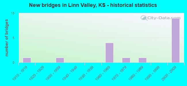
- New bridges - historical statistics
- 11910-1919
- 11930-1939
- 41960-1969
- 11970-1979
- 11980-1989
- 92000-2009


- Bridge Condition - Deck
- 41.7%Very good
- 41.7%Good
- 8.3%Fair
- 8.3%Poor

- Bridge Condition - Superstructure
- 50.0%Very good
- 25.0%Good
- 8.3%Satisfactory
- 8.3%Fair
- 8.3%Poor

- Bridge Condition - Substructure
- 58.3%Very good
- 8.3%Good
- 16.7%Satisfactory
- 8.3%Fair
- 8.3%Serious

- Bridge Condition - Channel
- 22.2%Good
- 22.2%Satisfactory
- 44.4%Fair
- 11.1%Poor

- Bridge Condition - Culverts
- 75.0%Good
- 25.0%Fair
Find on map >> Show street view
Structure Number: 540038, Location: 1.0N 1.5E OF LA CYGNES (Lat: 38.375033, Lng: -94.731894), Route carried "on" structure: County highway 1425, Year Built: 1967, Status: Posted for load, Structure Length: 1.88m (6.17ft), Average Daily Traffic: 57 (year 2006), Average Future Daily Traffic: 225 (year 2037), Design Load: H 15, Features Intersected: MIDDLE CREEK
Minimum Vertical Clearance: 30.47m (99.97ft), Kilometerpoint: 0.000, Lanes on structure: 2, Owner: County Highway Agency, Approaching Roadway Width: 7.3m (24.0ft), Material/Design: Concrete, Design/Construction: Culvert, Number Of Spans In Main Unit: 3, Length of Maximum Span: 6.1m (20.0ft), Curb-To-Curb Width: 9.4m (30.8ft), Out-to-Out Width: 9.9m (32.5ft)
Condition: Channel: Fair, Culverts: Fair, Operating Rating: 41.5 metric tons, Method Used To Determine Operating Rating: Load Factor (LF), Inventory Rating: 24.5 metric tons, Method Used To Determine Inventory Rating: Load Factor (LF), Structural Evaluation: Somewhat better than minimum adequacy, Deck Geometry: Better than present minimum criteria, Waterway Adequacy: Somewhat better than minimum adequacy, Approach Roadway Alignment: Equal to present minimum criteria, Designated Inspection Frequency: Every 24 months, Inspection Date: January 2022
Find on map >> Show street view
Structure Number: 61057, Location: 2.0W OF JINGO (Lat: 38.404578, Lng: -94.733072), Route carried "on" structure: County highway 1425, Year Built: 1983, Status: Open, Structure Length: 0.98m (3.22ft), Average Daily Traffic: 115 (year 2011), Truck Traffic: 10%, Average Future Daily Traffic: 169 (year 2041), Design Load: H 20, Features Intersected: TRIB. MARAIS DES CYGNES, Facility Carried by Structure: NEW LANCASTER
Minimum Vertical Clearance: 30.47m (99.97ft), Kilometerpoint: 1.738, Lanes on structure: 2, Owner: County Highway Agency, Approaching Roadway Width: 7.3m (24.0ft), Material/Design: Concrete, Design/Construction: Culvert, Number Of Spans In Main Unit: 3, Length of Maximum Span: 3.0m (9.8ft), Curb-To-Curb Width: 8.0m (26.2ft), Out-to-Out Width: 8.4m (27.6ft)
Condition: Channel: Satisfactory, Culverts: Good, Operating Rating: 30.8 metric tons, Method Used To Determine Operating Rating: Allowable Stress (AS), Inventory Rating: 21.8 metric tons, Method Used To Determine Inventory Rating: Allowable Stress (AS), Structural Evaluation: Equal to present minimum criteria, Deck Geometry: Somewhat better than minimum adequacy, Waterway Adequacy: Better than present minimum criteria, Approach Roadway Alignment: Equal to present desirable criteria, Designated Inspection Frequency: Every 24 months, Inspection Date: June 2021, Wearing Surface/Protective System: Wearing Surface: Gravel
Find on map >> Show street view
Structure Number: 61058, Location: 9.1S 7.8E OF PAOLA (Lat: 38.440914, Lng: -94.732783), Route carried "on" structure: County highway 1425, Year Built: 1910, Year Reconstructed: 1930, Status: Posted for load, Structure Length: 0.83m (2.72ft), Average Daily Traffic: 105 (year 2011), Truck Traffic: 10%, Average Future Daily Traffic: 223 (year 2041), Features Intersected: STREAM, Facility Carried by Structure: NEW LANCASTER
Minimum Vertical Clearance: 30.47m (99.97ft), Kilometerpoint: 5.765, Lanes on structure: 2, Owner: County Highway Agency, Approaching Roadway Width: 7.7m (25.3ft), Material/Design: Concrete, Design/Construction: Slab, Number Of Spans In Main Unit: 2, Length of Maximum Span: 4.1m (13.5ft), Curb-To-Curb Width: 7.0m (23.0ft), Out-to-Out Width: 7.3m (24.0ft)
Condition: Deck: Good, Superstructure: Good, Substructure: Satisfactory, Channel: Fair, Operating Rating: 23.6 metric tons, Method Used To Determine Operating Rating: Allowable Stress (AS), Inventory Rating: 15.4 metric tons, Method Used To Determine Inventory Rating: Allowable Stress (AS), Structural Evaluation: Meets minimum limits, Deck Geometry: Meets minimum limits, Waterway Adequacy: Equal to present desirable criteria, Approach Roadway Alignment: Equal to present minimum criteria, Length Of Structure Improvement: 1.22m (4.00ft), Designated Inspection Frequency: Every 24 months, Inspection Date: May 2021, Bridge Improvement Cost: $150,000, Roadway Improvement Cost: $95,000, Total Project Cost: $250,000, Deck Structure Type: Concrete Cast-file-Place, Wearing Surface/Protective System: Wearing Surface: Gravel
Find on map >> Show street view
Structure Number: 541107005267, Location: 4.0E 0.3N OF LA CYGNE (Lat: 38.351172, Lng: -94.678106), Route carried "on" structure: County highway , Year Built: 1969, Status: Open, Structure Length: 0.67m (2.20ft), Average Daily Traffic: 25 (year 2006), Average Future Daily Traffic: 50 (year 2037), Features Intersected: TRIB. TO SUGAR CREEK, Facility Carried by Structure: LOCAL RD. 9
Minimum Vertical Clearance: 30.47m (99.97ft), Kilometerpoint: 0.000, Lanes on structure: 2, Owner: County Highway Agency, Approaching Roadway Width: 6.7m (22.0ft), Material/Design: Concrete, Design/Construction: Culvert, Number Of Spans In Main Unit: 2, Length of Maximum Span: 3.0m (9.8ft), Curb-To-Curb Width: 7.3m (24.0ft), Out-to-Out Width: 7.9m (25.9ft)
Condition: Channel: Fair, Culverts: Good, Operating Rating: 31.5 metric tons, Method Used To Determine Operating Rating: Load Testing, Inventory Rating: 19.1 metric tons, Method Used To Determine Inventory Rating: Load Testing, Structural Evaluation: Somewhat better than minimum adequacy, Deck Geometry: Equal to present minimum criteria, Waterway Adequacy: Better than present minimum criteria, Approach Roadway Alignment: Equal to present desirable criteria, Designated Inspection Frequency: Every 24 months, Inspection Date: January 2022
Find on map >> Show street view
Structure Number: 611101505145, Location: 1.4S 0.5E NEW LANCASTER (Lat: 38.440067, Lng: -94.723003), Route carried "on" structure: County highway , Year Built: 1930, Status: Posted for load, Structure Length: 0.69m (2.26ft), Average Daily Traffic: 65 (year 2011), Average Future Daily Traffic: 54 (year 2041), Features Intersected: TRIB. TO MIDDLE CREEK, Facility Carried by Structure: 379th Street
Minimum Vertical Clearance: 30.47m (99.97ft), Kilometerpoint: 0.000, Lanes on structure: 1, Owner: County Highway Agency, Approaching Roadway Width: 4.8m (15.7ft), Material/Design: Concrete, Design/Construction: Slab, Number Of Spans In Main Unit: 1, Length of Maximum Span: 6.1m (20.0ft), Curb-To-Curb Width: 4.6m (15.1ft), Out-to-Out Width: 5.4m (17.7ft)
Condition: Deck: Fair, Superstructure: Fair, Substructure: Fair, Channel: Fair, Operating Rating: 13.6 metric tons, Method Used To Determine Operating Rating: Allowable Stress (AS), Inventory Rating: 9.1 metric tons, Method Used To Determine Inventory Rating: Allowable Stress (AS), Structural Evaluation: High priority of replacement, Deck Geometry: Better than present minimum criteria, Waterway Adequacy: Equal to present minimum criteria, Approach Roadway Alignment: Meets minimum limits, Bridge Posting: Required (Relationship of Operating Rating to Maximum Legal Load: 30.0 - 39.9% below), Length Of Structure Improvement: 1.37m (4.49ft), Designated Inspection Frequency: Every 24 months, Inspection Date: May 2021, Bridge Improvement Cost: $200,000, Roadway Improvement Cost: $95,000, Total Project Cost: $300,000, Deck Structure Type: Concrete Cast-file-Place
Find on map >> Show street view
Structure Number: 61110530516, Location: 2.0S 2.3E NEW LANCASTER (Lat: 38.432764, Lng: -94.689439), Route carried "on" structure: County highway , Year Built: 2004, Status: Open, Structure Length: 0.72m (2.36ft), Average Daily Traffic: 28 (year 2011), Average Future Daily Traffic: 49 (year 2041), Design Load: HS 20, Features Intersected: TRIB. TO ELM CREEK, Facility Carried by Structure: 383rd ST
Minimum Vertical Clearance: 30.47m (99.97ft), Kilometerpoint: 0.000, Lanes on structure: 2, Owner: County Highway Agency, Approaching Roadway Width: 9.7m (31.8ft), Skew: 4 degrees, Material/Design: Concrete, Design/Construction: Culvert, Number Of Spans In Main Unit: 2, Length of Maximum Span: 3.4m (11.2ft)
Condition: Channel: Good, Culverts: Good, Operating Rating: 72.6 metric tons, Method Used To Determine Operating Rating: Load Factor (LF), Inventory Rating: 43.5 metric tons, Method Used To Determine Inventory Rating: Load Factor (LF), Structural Evaluation: Better than present minimum criteria, Waterway Adequacy: Equal to present desirable criteria, Approach Roadway Alignment: Equal to present desirable criteria, Length Of Structure Improvement: 0.76m (2.49ft), Designated Inspection Frequency: Every 24 months, Inspection Date: May 2021, Bridge Improvement Cost: $24,000, Roadway Improvement Cost: $2,000, Total Project Cost: $36,000, Wearing Surface/Protective System: Wearing Surface: Gravel
Find on map >> Show street view
Structure Number: 61110560516, Location: 2.0N 0.6E OF JINGO (Lat: 38.432686, Lng: -94.684453), Route carried "on" structure: County highway , Year Built: 2004, Status: Open, Structure Length: 5.46m (17.91ft), Average Daily Traffic: 28 (year 2011), Average Future Daily Traffic: 49 (year 2041), Design Load: HL 93, Features Intersected: ELM CREEK, Facility Carried by Structure: 383rd ST
Minimum Vertical Clearance: 30.47m (99.97ft), Kilometerpoint: 0.000, Lanes on structure: 2, Owner: County Highway Agency, Approaching Roadway Width: 7.3m (24.0ft), Material/Design: Prestressed concrete continuous, Design/Construction: Stringer/Multi-beam, Number Of Spans In Main Unit: 3, Length of Maximum Span: 18.0m (59.1ft), Curb-To-Curb Width: 8.6m (28.2ft), Out-to-Out Width: 9.2m (30.2ft)
Condition: Deck: Very good, Superstructure: Very good, Substructure: Good, Channel: Satisfactory, Operating Rating: 56.4 metric tons, Method Used To Determine Operating Rating: Load and Resistance Factor Rating (LRFR) rating reported by rating factor(RF) method using HL-93 loadings, Inventory Rating: 43.4 metric tons, Method Used To Determine Inventory Rating: Load and Resistance Factor Rating (LRFR) rating reported by rating factor(RF) method using HL-93 loadings, Structural Evaluation: Better than present minimum criteria, Deck Geometry: Better than present minimum criteria, Waterway Adequacy: Equal to present desirable criteria, Approach Roadway Alignment: Equal to present desirable criteria, Designated Inspection Frequency: Every 24 months, Inspection Date: May 2021, Deck Structure Type: Concrete Cast-file-Place
Find on map >> Show street view
Structure Number: 611109005187, Location: 12.0E 11.5S OF PAOLA (Lat: 38.408183, Lng: -94.659842), Route carried "on" structure: County highway 6113, Year Built: 1971, Status: Open, Structure Length: 3.54m (11.61ft), Average Daily Traffic: 66 (year 2011), Average Future Daily Traffic: 67 (year 2041), Features Intersected: ELM CREEK, Facility Carried by Structure: Rockville RD
Minimum Vertical Clearance: 30.47m (99.97ft), Kilometerpoint: 0.000, Lanes on structure: 2, Owner: County Highway Agency, Approaching Roadway Width: 8.5m (27.9ft), Material/Design: Prestressed concrete, Design/Construction: Tee Beam, Number Of Spans In Main Unit: 2, Length of Maximum Span: 17.4m (57.1ft), Curb-To-Curb Width: 8.6m (28.2ft), Out-to-Out Width: 9.4m (30.8ft)
Condition: Deck: Good, Superstructure: Satisfactory, Substructure: Satisfactory, Channel: Good, Operating Rating: 45.4 metric tons, Method Used To Determine Operating Rating: Allowable Stress (AS), Inventory Rating: 28.1 metric tons, Method Used To Determine Inventory Rating: Allowable Stress (AS), Structural Evaluation: Equal to present minimum criteria, Deck Geometry: Better than present minimum criteria, Waterway Adequacy: Better than present minimum criteria, Approach Roadway Alignment: Better than present minimum criteria, Designated Inspection Frequency: Every 24 months, Underwater Inspection Frequency: Every 60 months, Inspection Date: June 2021, Underwater Inspection Date: September 2021, Deck Structure Type: Other, Wearing Surface/Protective System: Wearing Surface: Monolithic Concrete
Find on map >> Show street view
Structure Number: 6111094052, Location: 4.4E 4.0S NEW LANCASTER (Lat: 38.402133, Lng: -94.653033), Route carried "on" structure: County highway 6104, Year Built: 1962, Status: Posted for load, Structure Length: 3.17m (10.40ft), Average Daily Traffic: 95 (year 2015), Truck Traffic: 1%, Average Future Daily Traffic: 146 (year 2041), Features Intersected: LA CYGNE LAKE, Facility Carried by Structure: 399th ST
Minimum Vertical Clearance: 30.47m (99.97ft), Kilometerpoint: 0.000, Lanes on structure: 2, Owner: County Highway Agency, Approaching Roadway Width: 6.7m (22.0ft), Material/Design: Steel, Design/Construction: Truss - Thru, Number Of Spans In Main Unit: 1, Length of Maximum Span: 30.5m (100.1ft), Curb-To-Curb Width: 6.5m (21.3ft), Out-to-Out Width: 6.6m (21.7ft)
Condition: Deck: Poor, Superstructure: Poor, Substructure: Serious, Channel: Poor, Operating Rating: 11.4 metric tons, Method Used To Determine Operating Rating: Load Factor (LF), Inventory Rating: 6.9 metric tons, Method Used To Determine Inventory Rating: Load Factor (LF), Structural Evaluation: High priority of replacement, Deck Geometry: Somewhat better than minimum adequacy, Waterway Adequacy: Equal to present desirable criteria, Approach Roadway Alignment: High priority of replacement, Bridge Posting: Required (Relationship of Operating Rating to Maximum Legal Load: > 39.9% below), Length Of Structure Improvement: 6.10m (20.01ft), Designated Inspection Frequency: Every 12 months, Critical Feature Inspection Frequency: Every 24 months, Inspection Date: June 2021, Critical Feature Inspection Date: June 2021, Bridge Improvement Cost: $900,000, Roadway Improvement Cost: $295,000, Total Project Cost: $120,000, Deck Structure Type: Concrete Cast-file-Place
Find on map >> Show street view
Structure Number: 999906900540091, Location: AT US-69 & K-152JCT (Lat: 38.345000, Lng: -94.682500), Route carried "on" structure: US 69, Year Built: 1964, Status: Open, Structure Length: 4.37m (14.34ft), Average Daily Traffic: 3,108 (year 2020), Truck Traffic: 21%, Average Future Daily Traffic: 5,093 (year 2041), Design Load: HS 20, Features Intersected: K152 HWY
Minimum Vertical Clearance: 30.47m (99.97ft), Kilometerpoint: 35.874, Lanes on structure: 2, Lanes under structure: 2, Base Highway Network: Yes, Owner: State Highway Agency, Approaching Roadway Width: 13.4m (44.0ft), Skew: 2 degrees, Material/Design: Steel continuous, Design/Construction: Stringer/Multi-beam, Number Of Spans In Main Unit: 3, Length of Maximum Span: 17.1m (56.1ft), Curb-To-Curb Width: 13.4m (44.0ft), Out-to-Out Width: 14.0m (45.9ft)
Condition: Deck: Good, Superstructure: Good, Substructure: Very good, Operating Rating: 40.4 metric tons, Method Used To Determine Operating Rating: Load Factor (LF), Inventory Rating: 24.2 metric tons, Method Used To Determine Inventory Rating: Load Factor (LF), Structural Evaluation: Equal to present minimum criteria, Deck Geometry: Superior to present desirable criteria, Underclear: Equal to present desirable criteria, Approach Roadway Alignment: Equal to present desirable criteria, Length Of Structure Improvement: 14.32m (46.98ft), Designated Inspection Frequency: Every 24 months, Inspection Date: March 2020, Deck Structure Type: Concrete Cast-file-Place, Wearing Surface/Protective System: Wearing Surface: Low Slump Concrete
Find on map >> Show street view
Structure Number: 999906900540481, Location: AT K-152/U-69 JCT (Lat: 38.345000, Lng: -94.682778), Route carried "on" structure: US 69, Year Built: 2005, Status: Open, Structure Length: 4.35m (14.27ft), Average Daily Traffic: 3,108 (year 2020), Truck Traffic: 21%, Average Future Daily Traffic: 4,710 (year 2041), Design Load: HL 93, Features Intersected: K-152 HWY
Minimum Vertical Clearance: 30.47m (99.97ft), Kilometerpoint: 35.874, Lanes on structure: 2, Lanes under structure: 2, Base Highway Network: Yes, Owner: State Highway Agency, Approaching Roadway Width: 12.2m (40.0ft), Material/Design: Steel continuous, Design/Construction: Stringer/Multi-beam, Number Of Spans In Main Unit: 3, Length of Maximum Span: 17.1m (56.1ft), Curb-To-Curb Width: 12.2m (40.0ft), Out-to-Out Width: 12.8m (42.0ft)
Condition: Deck: Very good, Superstructure: Very good, Substructure: Very good, Operating Rating: 97.2 metric tons, Method Used To Determine Operating Rating: Load and Resistance Factor Rating (LRFR) rating reported by rating factor(RF) method using HL-93 loadings, Inventory Rating: 86.5 metric tons, Method Used To Determine Inventory Rating: Load and Resistance Factor Rating (LRFR) rating reported by rating factor(RF) method using HL-93 loadings, Structural Evaluation: Equal to present desirable criteria, Deck Geometry: Better than present minimum criteria, Underclear: Equal to present desirable criteria, Approach Roadway Alignment: Equal to present desirable criteria, Length Of Structure Improvement: 14.26m (46.78ft), Designated Inspection Frequency: Every 24 months, Inspection Date: March 2020, Wearing Surface/Protective System: Wearing Surface: Low Slump Concrete, Deck Protection: Epoxy Coated Reinforcing
Find on map >> Show street view
Structure Number: 999906900540491, Location: 2.1 MI N K-152/U-69 JCT (Lat: 38.374167, Lng: -94.687222), Route carried "on" structure: US 69, Year Built: 2005, Status: Open, Structure Length: 5.75m (18.86ft), Average Daily Traffic: 3,799 (year 2020), Truck Traffic: 20%, Average Future Daily Traffic: 6,225 (year 2041), Design Load: HL 93, Features Intersected: EAST 2400 ROAD
Minimum Vertical Clearance: 30.47m (99.97ft), Kilometerpoint: 39.176, Lanes on structure: 2, Lanes under structure: 2, Base Highway Network: Yes, Owner: State Highway Agency, Approaching Roadway Width: 12.2m (40.0ft), Material/Design: Prestressed concrete continuous, Design/Construction: Stringer/Multi-beam, Number Of Spans In Main Unit: 3, Length of Maximum Span: 20.0m (65.6ft), Curb-To-Curb Width: 12.2m (40.0ft), Out-to-Out Width: 12.8m (42.0ft)
Condition: Deck: Good, Superstructure: Very good, Substructure: Very good, Operating Rating: 53.8 metric tons, Method Used To Determine Operating Rating: Load and Resistance Factor Rating (LRFR) rating reported by rating factor(RF) method using HL-93 loadings, Inventory Rating: 37.6 metric tons, Method Used To Determine Inventory Rating: Load and Resistance Factor Rating (LRFR) rating reported by rating factor(RF) method using HL-93 loadings, Structural Evaluation: Equal to present desirable criteria, Deck Geometry: Better than present minimum criteria, Underclear: Meets minimum limits, Approach Roadway Alignment: Equal to present desirable criteria, Length Of Structure Improvement: 18.88m (61.94ft), Designated Inspection Frequency: Every 24 months, Inspection Date: March 2020, Wearing Surface/Protective System: Wearing Surface: Low Slump Concrete, Deck Protection: Epoxy Coated Reinforcing
Find on map >> Show street view
Structure Number: 999906900540501, Location: 2.1 MI N K-152/U-69 JCT (Lat: 38.374444, Lng: -94.687500), Route carried "on" structure: US 69, Year Built: 2008, Status: Open, Structure Length: 5.75m (18.86ft), Average Daily Traffic: 3,799 (year 2020), Truck Traffic: 20%, Average Future Daily Traffic: 6,225 (year 2041), Design Load: HL 93, Features Intersected: EAST 2400 ROAD
Minimum Vertical Clearance: 30.47m (99.97ft), Kilometerpoint: 39.176, Lanes on structure: 2, Lanes under structure: 2, Base Highway Network: Yes, Owner: State Highway Agency, Approaching Roadway Width: 12.2m (40.0ft), Material/Design: Prestressed concrete continuous, Design/Construction: Stringer/Multi-beam, Number Of Spans In Main Unit: 3, Length of Maximum Span: 20.0m (65.6ft), Curb-To-Curb Width: 12.2m (40.0ft), Out-to-Out Width: 12.8m (42.0ft)
Condition: Deck: Very good, Superstructure: Very good, Substructure: Very good, Operating Rating: 53.8 metric tons, Method Used To Determine Operating Rating: Load and Resistance Factor Rating (LRFR) rating reported by rating factor(RF) method using HL-93 loadings, Inventory Rating: 37.6 metric tons, Method Used To Determine Inventory Rating: Load and Resistance Factor Rating (LRFR) rating reported by rating factor(RF) method using HL-93 loadings, Structural Evaluation: Equal to present desirable criteria, Deck Geometry: Better than present minimum criteria, Underclear: Meets minimum limits, Approach Roadway Alignment: Equal to present desirable criteria, Length Of Structure Improvement: 18.88m (61.94ft), Designated Inspection Frequency: Every 24 months, Inspection Date: March 2020, Wearing Surface/Protective System: Wearing Surface: Low Slump Concrete, Deck Protection: Epoxy Coated Reinforcing
Find on map >> Show street view
Structure Number: 999906900611121, Location: .98 Miles N of SCOLN (Lat: 38.403056, Lng: -94.687778), Route carried "on" structure: County highway 1022, Year Built: 2004, Status: Open, Structure Length: 8.99m (29.49ft), Average Daily Traffic: 34 (year 2020), Truck Traffic: 6%, Average Future Daily Traffic: 6,833 (year 2041), Design Load: HL 93, Features Intersected: NB & SB US69 HWY, Facility Carried by Structure: 399TH ST
Minimum Vertical Clearance: 30.47m (99.97ft), Kilometerpoint: 3.954, Lanes on structure: 2, Lanes under structure: 5, Owner: State Highway Agency, Approaching Roadway Width: 11.0m (36.1ft), Material/Design: Steel continuous, Design/Construction: Stringer/Multi-beam, Number Of Spans In Main Unit: 4, Length of Maximum Span: 27.8m (91.2ft), Curb-To-Curb Width: 11.0m (36.1ft), Out-to-Out Width: 11.6m (38.1ft)
Condition: Deck: Very good, Superstructure: Very good, Substructure: Very good, Operating Rating: 48.6 metric tons, Method Used To Determine Operating Rating: Load and Resistance Factor Rating (LRFR) rating reported by rating factor(RF) method using HL-93 loadings, Inventory Rating: 37.6 metric tons, Method Used To Determine Inventory Rating: Load and Resistance Factor Rating (LRFR) rating reported by rating factor(RF) method using HL-93 loadings, Structural Evaluation: Equal to present desirable criteria, Deck Geometry: Superior to present desirable criteria, Underclear: Superior to present desirable criteria, Approach Roadway Alignment: Meets minimum limits, Length Of Structure Improvement: 29.51m (96.82ft), Designated Inspection Frequency: Every 24 months, Inspection Date: March 2020, Wearing Surface/Protective System: Wearing Surface: Monolithic Concrete, Deck Protection: Epoxy Coated Reinforcing
Find on map >> Show street view
Structure Number: 999906900611141, Location: 3.02 MI N SCOLN (Lat: 38.432500, Lng: -94.686944), Route carried "on" structure: US 69, Year Built: 2004, Status: Open, Structure Length: 6.01m (19.72ft), Average Daily Traffic: 4,057 (year 2020), Truck Traffic: 19%, Average Future Daily Traffic: 6,648 (year 2041), Design Load: HL 93, Features Intersected: 383RD STREET
Minimum Vertical Clearance: 30.47m (99.97ft), Kilometerpoint: 4.857, Lanes on structure: 2, Lanes under structure: 2, Base Highway Network: Yes, Owner: State Highway Agency, Approaching Roadway Width: 12.2m (40.0ft), Material/Design: Prestressed concrete continuous, Design/Construction: Stringer/Multi-beam, Number Of Spans In Main Unit: 3, Length of Maximum Span: 20.0m (65.6ft), Curb-To-Curb Width: 12.2m (40.0ft), Out-to-Out Width: 12.8m (42.0ft)
Condition: Deck: Very good, Superstructure: Very good, Substructure: Very good, Operating Rating: 54.4 metric tons, Method Used To Determine Operating Rating: Load and Resistance Factor Rating (LRFR) rating reported by rating factor(RF) method using HL-93 loadings, Inventory Rating: 37.6 metric tons, Method Used To Determine Inventory Rating: Load and Resistance Factor Rating (LRFR) rating reported by rating factor(RF) method using HL-93 loadings, Structural Evaluation: Equal to present desirable criteria, Deck Geometry: Better than present minimum criteria, Underclear: Superior to present desirable criteria, Approach Roadway Alignment: Equal to present desirable criteria, Length Of Structure Improvement: 19.73m (64.73ft), Designated Inspection Frequency: Every 24 months, Inspection Date: March 2020, Wearing Surface/Protective System: Wearing Surface: Low Slump Concrete, Deck Protection: Epoxy Coated Reinforcing
Find on map >> Show street view
Structure Number: 999906900611151, Location: 3.02 MI N SCOLN (Lat: 38.432500, Lng: -94.686667), Route carried "on" structure: US 69, Year Built: 2005, Status: Open, Structure Length: 6.01m (19.72ft), Average Daily Traffic: 4,057 (year 2020), Truck Traffic: 19%, Average Future Daily Traffic: 6,648 (year 2041), Design Load: HL 93, Features Intersected: 383RD STREET
Minimum Vertical Clearance: 30.47m (99.97ft), Kilometerpoint: 4.855, Lanes on structure: 2, Lanes under structure: 2, Base Highway Network: Yes, Owner: State Highway Agency, Approaching Roadway Width: 12.2m (40.0ft), Material/Design: Prestressed concrete continuous, Design/Construction: Stringer/Multi-beam, Number Of Spans In Main Unit: 3, Length of Maximum Span: 20.0m (65.6ft), Curb-To-Curb Width: 12.2m (40.0ft), Out-to-Out Width: 12.8m (42.0ft)
Condition: Deck: Good, Superstructure: Good, Substructure: Very good, Operating Rating: 49.2 metric tons, Method Used To Determine Operating Rating: Load and Resistance Factor Rating (LRFR) rating reported by rating factor(RF) method using HL-93 loadings, Inventory Rating: 36.0 metric tons, Method Used To Determine Inventory Rating: Load and Resistance Factor Rating (LRFR) rating reported by rating factor(RF) method using HL-93 loadings, Structural Evaluation: Better than present minimum criteria, Deck Geometry: Better than present minimum criteria, Underclear: Superior to present desirable criteria, Approach Roadway Alignment: Equal to present desirable criteria, Length Of Structure Improvement: 19.73m (64.73ft), Designated Inspection Frequency: Every 24 months, Inspection Date: March 2020, Wearing Surface/Protective System: Wearing Surface: Low Slump Concrete, Deck Protection: Epoxy Coated Reinforcing
Find on map >> Show street view
Structure Number: 999906900611121, Location: .98 Miles N of SCOLN (Lat: 38.403056, Lng: -94.687778), Route carried "under" structure: County highway 1022, Year Built: 2004, Structure Length: 0. m, Average Daily Traffic: 4,057 (year 2020), Truck Traffic: 19%, Features Intersected: NB & SB US69 HWY, Facility Carried by Structure: 399TH ST
Minimum Vertical Clearance: 5.16m (16.93ft), Kilometerpoint: 3.938, Lanes on structure: 2, Lanes under structure: 5, Material/Design: Steel continuous, Design/Construction: Stringer/Multi-beam, Length of Maximum Span: 27.8m (91.2ft)