Bridge Statistics for Linthicum, Maryland (MD)
Condition, Traffic, Stress, Structural Evaluation, Project Costs
- National Bridge Inventory (NBI) Statistics
- 49Number of bridges
- 942ft / 287mTotal length
- $6,952,000Total costs
- 1,568,386Total average daily traffic
- 73,012Total average daily truck traffic
- National Bridge Inventory (NBI) Registered Bridges for Linthicum
- No street view available for this location
- New bridges - historical statistics
- 71940-1949
- 31950-1959
- 11960-1969
- 11970-1979
- 61980-1989
- 251990-1999
- 62000-2009
- Reconstructed bridges - Historical Statistics
- 21990-1999
- 32000-2009
- Bridge Condition - Deck
- 6.7%Very good
- 76.7%Good
- 13.3%Satisfactory
- 3.3%Fair
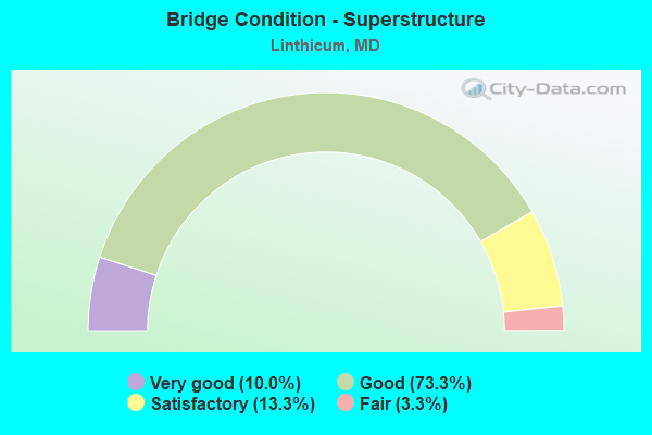
- Bridge Condition - Superstructure
- 10.0%Very good
- 73.3%Good
- 13.3%Satisfactory
- 3.3%Fair
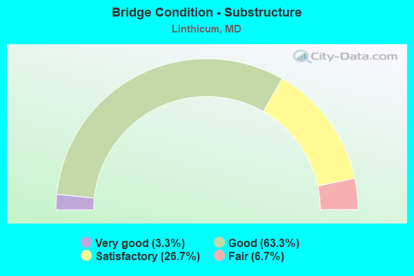
- Bridge Condition - Substructure
- 3.3%Very good
- 63.3%Good
- 26.7%Satisfactory
- 6.7%Fair
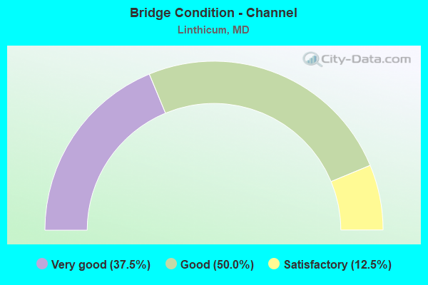
- Bridge Condition - Channel
- 37.5%Very good
- 50.0%Good
- 12.5%Satisfactory
Find on map >> Show street view
Structure Number: 10000002001301, Location: 0.53 MI S OF MD 168 (Lat: 39.217364, Lng: -76.663511), Route carried "on" structure: County highway 17, Year Built: 1949, Status: Open, Structure Length: 1.83m (6.00ft), Average Daily Traffic: 2,892 (year 2008), Truck Traffic: 5%, Average Future Daily Traffic: 3,334 (year 2028), Design Load: H 20, Features Intersected: MD 295 NBR, Facility Carried by Structure: HAMMONDS FERRY RD
Minimum Vertical Clearance: 30+ m (98+ ft), Kilometerpoint: 2.542, Lanes on structure: 2, Lanes under structure: 3, Owner: State Highway Agency, Approaching Roadway Width: 13.4m (44.0ft), Material/Design: Steel, Design/Construction: Stringer/Multi-beam, Number Of Spans In Main Unit: 1, Length of Maximum Span: 16.8m (55.1ft), Curb or Sidewalk Widths: Left: 1.2m (3.9ft), Right: 1.2m (3.9ft), Curb-To-Curb Width: 13.4m (44.0ft), Out-to-Out Width: 16.9m (55.4ft)
Condition: Deck: Good, Superstructure: Good, Substructure: Satisfactory, Operating Rating: 83.4 metric tons, Method Used To Determine Operating Rating: Load Factor (LF), Inventory Rating: 49.9 metric tons, Method Used To Determine Inventory Rating: Load Factor (LF), Structural Evaluation: Equal to present minimum criteria, Deck Geometry: Better than present minimum criteria, Underclear: High priority of corrective action, Approach Roadway Alignment: Equal to present desirable criteria, Length Of Structure Improvement: 1.83m (6.00ft), Designated Inspection Frequency: Every 24 months, Inspection Date: March 2021, Bridge Improvement Cost: $200,000, Roadway Improvement Cost: $20,000, Total Project Cost: $220,000, Deck Structure Type: Concrete Cast-file-Place, Wearing Surface/Protective System: Wearing Surface: Bituminous
Find on map >> Show street view
Structure Number: 10000002001401, Location: 1.23 MI N OF IS 195 (Lat: 39.212256, Lng: -76.678311), Route carried "on" structure: County highway 6, Year Built: 1949, Year Reconstructed: 2013, Status: Open, Structure Length: 2.32m (7.61ft), Average Daily Traffic: 9,020 (year 2009), Truck Traffic: 5%, Average Future Daily Traffic: 17,857 (year 2026), Design Load: H 20, Features Intersected: MD 295 NBR, Facility Carried by Structure: WEST NURSERY ROAD
Minimum Vertical Clearance: 30+ m (98+ ft), Kilometerpoint: 1.963, Lanes on structure: 2, Lanes under structure: 2, Owner: State Highway Agency, Approaching Roadway Width: 12.2m (40.0ft), Skew: 3 degrees, Material/Design: Steel, Design/Construction: Stringer/Multi-beam, Number Of Spans In Main Unit: 1, Length of Maximum Span: 21.3m (69.9ft), Curb or Sidewalk Widths: Left: 1.2m (3.9ft), Right: 1.2m (3.9ft), Curb-To-Curb Width: 13.4m (44.0ft), Out-to-Out Width: 18.0m (59.1ft)
Condition: Deck: Very good, Superstructure: Very good, Substructure: Satisfactory, Operating Rating: 97.2 metric tons, Method Used To Determine Operating Rating: Load and Resistance Factor Rating (LRFR) rating reported by rating factor(RF) method using HL-93 loadings, Inventory Rating: 75.5 metric tons, Method Used To Determine Inventory Rating: Load and Resistance Factor Rating (LRFR) rating reported by rating factor(RF) method using HL-93 loadings, Structural Evaluation: Equal to present minimum criteria, Deck Geometry: Equal to present minimum criteria, Underclear: Somewhat better than minimum adequacy, Approach Roadway Alignment: Equal to present desirable criteria, Length Of Structure Improvement: 2.32m (7.61ft), Designated Inspection Frequency: Every 24 months, Inspection Date: April 2021, Bridge Improvement Cost: $242,000, Roadway Improvement Cost: $24,000, Total Project Cost: $266,000, Deck Structure Type: Concrete Cast-file-Place, Wearing Surface/Protective System: Wearing Surface: Bituminous
Find on map >> Show street view
Structure Number: 10000002001501, Location: 0.8 MI E OF CONCORSE DRIV (Lat: 39.204828, Lng: -76.689375), Route carried "on" structure: County highway 8, Year Built: 1990, Status: Open, Structure Length: 3.20m (10.50ft), Average Daily Traffic: 7,530 (year 2007), Truck Traffic: 8%, Average Future Daily Traffic: 8,682 (year 2026), Design Load: HS 20, Features Intersected: MD 295 NBR, Facility Carried by Structure: WINTERSON ROAD
Minimum Vertical Clearance: 30+ m (98+ ft), Kilometerpoint: 0.209, Lanes on structure: 2, Lanes under structure: 3, Owner: State Highway Agency, Approaching Roadway Width: 13.4m (44.0ft), Skew: 2 degrees, Material/Design: Steel, Design/Construction: Stringer/Multi-beam, Number Of Spans In Main Unit: 1, Length of Maximum Span: 30.5m (100.1ft), Curb or Sidewalk Widths: Left: 1.6m (5.2ft), Right: 0.0m, Curb-To-Curb Width: 13.5m (44.3ft), Out-to-Out Width: 15.9m (52.2ft)
Condition: Deck: Good, Superstructure: Good, Substructure: Good, Inventory Rating: 67.1 metric tons, Method Used To Determine Inventory Rating: Load Factor (LF), Structural Evaluation: Better than present minimum criteria, Deck Geometry: Superior to present desirable criteria, Underclear: Better than present minimum criteria, Approach Roadway Alignment: Equal to present desirable criteria, Designated Inspection Frequency: Every 24 months, Inspection Date: June 2021, Deck Structure Type: Concrete Cast-file-Place, Wearing Surface/Protective System: Wearing Surface: Monolithic Concrete, Deck Protection: Epoxy Coated Reinforcing
Find on map >> Show street view
Structure Number: 10000002001601, Location: 0.84 MI S OF HOWARD CO (Lat: 39.202647, Lng: -76.691742), Route carried "on" structure: Ramp State highway 295, Year Built: 1990, Status: Open, Structure Length: 4.54m (14.90ft), Average Daily Traffic: 10,897 (year 2006), Truck Traffic: 8%, Average Future Daily Traffic: 12,534 (year 2026), Design Load: HS 20+Mod, Features Intersected: MD 295 NBR
Minimum Vertical Clearance: 30+ m (98+ ft), Kilometerpoint: 0.434, Lanes on structure: 1, Lanes under structure: 2, Base Highway Network: Yes, Owner: State Highway Agency, Approaching Roadway Width: 8.8m (28.9ft), Skew: 5 degrees, Material/Design: Steel, Design/Construction: Stringer/Multi-beam, Number Of Spans In Main Unit: 1, Length of Maximum Span: 42.4m (139.1ft), Curb-To-Curb Width: 8.8m (28.9ft), Out-to-Out Width: 10.1m (33.1ft)
Condition: Deck: Good, Superstructure: Good, Substructure: Good, Inventory Rating: 76.2 metric tons, Method Used To Determine Inventory Rating: Load Factor (LF), Structural Evaluation: Better than present minimum criteria, Deck Geometry: Superior to present desirable criteria, Underclear: Equal to present minimum criteria, Approach Roadway Alignment: Equal to present desirable criteria, Designated Inspection Frequency: Every 24 months, Inspection Date: August 2021, Deck Structure Type: Concrete Cast-file-Place, Wearing Surface/Protective System: Wearing Surface: Monolithic Concrete, Deck Protection: Epoxy Coated Reinforcing
Find on map >> Show street view
Structure Number: 100000020018011, Location: 0.14 MI S OF IS 195 (Lat: 39.199333, Lng: -76.698172), Route carried "on" structure: State highway 295, Year Built: 1950, Year Reconstructed: 1990, Status: Open, Structure Length: 12.34m (40.49ft), Average Daily Traffic: 67,307 (year 2018), Truck Traffic: 8%, Average Future Daily Traffic: 144,589 (year 2040), Features Intersected: AMTRAK, STONY RUN
Minimum Vertical Clearance: 30+ m (98+ ft), Kilometerpoint: 18.740, Lanes on structure: 2, Base Highway Network: Yes, Owner: State Highway Agency, Approaching Roadway Width: 13.4m (44.0ft), Skew: 9 degrees, Material/Design: Steel, Design/Construction: Stringer/Multi-beam, Number Of Spans In Main Unit: 6, Length of Maximum Span: 26.2m (86.0ft), Curb-To-Curb Width: 13.4m (44.0ft), Out-to-Out Width: 14.4m (47.2ft)
Condition: Deck: Good, Superstructure: Satisfactory, Substructure: Fair, Channel: Good, Operating Rating: 80.7 metric tons, Method Used To Determine Operating Rating: Load Factor (LF), Inventory Rating: 48.5 metric tons, Method Used To Determine Inventory Rating: Load Factor (LF), Structural Evaluation: Somewhat better than minimum adequacy, Deck Geometry: Superior to present desirable criteria, Underclear: Equal to present minimum criteria, Waterway Adequacy: Equal to present desirable criteria, Approach Roadway Alignment: Equal to present desirable criteria, Designated Inspection Frequency: Every 24 months, Critical Feature Inspection Frequency: Every 24 months, Inspection Date: January 2020, Critical Feature Inspection Date: January 2020, Deck Structure Type: Concrete Cast-file-Place, Wearing Surface/Protective System: Wearing Surface: Monolithic Concrete, Deck Protection: Epoxy Coated Reinforcing
Find on map >> Show street view
Structure Number: 100000020018012, Location: 0.14 MI S OF IS 195 (Lat: 39.200311, Lng: -76.696981), Route carried "on" structure: State highway 295, Year Built: 1950, Year Reconstructed: 1990, Status: Open, Structure Length: 12.50m (41.01ft), Average Daily Traffic: 67,307 (year 2018), Truck Traffic: 8%, Average Future Daily Traffic: 144,588 (year 2040), Design Load: HS 20, Features Intersected: AMTRAK, STONY RUN
Minimum Vertical Clearance: 30+ m (98+ ft), Kilometerpoint: 18.740, Lanes on structure: 2, Base Highway Network: Yes, Owner: State Highway Agency, Approaching Roadway Width: 13.4m (44.0ft), Skew: 2 degrees, Material/Design: Steel, Design/Construction: Stringer/Multi-beam, Number Of Spans In Main Unit: 6, Length of Maximum Span: 27.7m (90.9ft), Curb-To-Curb Width: 13.4m (44.0ft), Out-to-Out Width: 14.4m (47.2ft)
Condition: Deck: Good, Superstructure: Satisfactory, Substructure: Fair, Channel: Good, Operating Rating: 64.9 metric tons, Method Used To Determine Operating Rating: Load Factor (LF), Inventory Rating: 38.5 metric tons, Method Used To Determine Inventory Rating: Load Factor (LF), Structural Evaluation: Somewhat better than minimum adequacy, Deck Geometry: Superior to present desirable criteria, Underclear: Equal to present minimum criteria, Waterway Adequacy: Equal to present desirable criteria, Approach Roadway Alignment: Equal to present desirable criteria, Designated Inspection Frequency: Every 24 months, Critical Feature Inspection Frequency: Every 24 months, Inspection Date: January 2020, Critical Feature Inspection Date: January 2020, Deck Structure Type: Concrete Cast-file-Place, Wearing Surface/Protective System: Wearing Surface: Monolithic Concrete, Deck Protection: Epoxy Coated Reinforcing
Find on map >> Show street view
Structure Number: 10000002005701, Location: 0.17 MILE NORTH OF MD 169 (Lat: 39.205639, Lng: -76.641472), Route carried "on" structure: State highway 648E, Year Built: 1989, Status: Open, Structure Length: 9.63m (31.59ft), Average Daily Traffic: 16,400 (year 2009), Truck Traffic: 8%, Average Future Daily Traffic: 19,762 (year 2026), Design Load: HS 20, Features Intersected: IS 695
Minimum Vertical Clearance: 30+ m (98+ ft), Kilometerpoint: 10.346, Lanes on structure: 4, Lanes under structure: 10, Owner: State Highway Agency, Approaching Roadway Width: 25.6m (84.0ft), Skew: 23 degrees, Material/Design: Steel continuous, Design/Construction: Stringer/Multi-beam, Number Of Spans In Main Unit: 2, Length of Maximum Span: 48.8m (160.1ft), Curb or Sidewalk Widths: Left: 1.6m (5.2ft), Right: 1.6m (5.2ft), Curb-To-Curb Width: 23.2m (76.1ft), Out-to-Out Width: 26.9m (88.3ft)
Condition: Deck: Good, Superstructure: Good, Substructure: Good, Operating Rating: 82.1 metric tons, Method Used To Determine Operating Rating: Load Factor (LF), Inventory Rating: 49.4 metric tons, Method Used To Determine Inventory Rating: Load Factor (LF), Structural Evaluation: Better than present minimum criteria, Deck Geometry: Superior to present desirable criteria, Underclear: Somewhat better than minimum adequacy, Approach Roadway Alignment: Equal to present desirable criteria, Designated Inspection Frequency: Every 24 months, Inspection Date: Febuary 2020, Deck Structure Type: Concrete Cast-file-Place, Wearing Surface/Protective System: Wearing Surface: Monolithic Concrete, Deck Protection: Epoxy Coated Reinforcing
Find on map >> Show street view
Structure Number: 100000020130013, Location: 1.09 MI E OF MD 170 (Lat: 39.200461, Lng: -76.694497), Route carried "on" structure: Interstate 195, Year Built: 1990, Status: Open, Structure Length: 15.30m (50.20ft), Average Daily Traffic: 39,015 (year 2009), Truck Traffic: 8%, Average Future Daily Traffic: 82,001 (year 2029), Design Load: HS 20+Mod, Features Intersected: MD 295
Minimum Vertical Clearance: 30+ m (98+ ft), Kilometerpoint: 2.516, Lanes on structure: 3, Lanes under structure: 6, Base Highway Network: Yes, Owner: State Highway Agency, Approaching Roadway Width: 18.3m (60.0ft), Material/Design: Steel continuous, Design/Construction: Stringer/Multi-beam, Number Of Spans In Main Unit: 3, Length of Maximum Span: 54.9m (180.1ft), Curb-To-Curb Width: 17.1m (56.1ft), Out-to-Out Width: 18.3m (60.0ft)
Condition: Deck: Good, Superstructure: Good, Substructure: Satisfactory, Inventory Rating: 67.6 metric tons, Method Used To Determine Inventory Rating: Load Factor (LF), Structural Evaluation: Equal to present minimum criteria, Deck Geometry: Equal to present minimum criteria, Underclear: Somewhat better than minimum adequacy, Approach Roadway Alignment: Equal to present desirable criteria, Designated Inspection Frequency: Every 24 months, Inspection Date: August 2020, Deck Structure Type: Concrete Cast-file-Place, Wearing Surface/Protective System: Wearing Surface: Monolithic Concrete, Deck Protection: Epoxy Coated Reinforcing
Find on map >> Show street view
Structure Number: 100000020130014, Location: 1.09 MI E OF MD 170 (Lat: 39.201528, Lng: -76.695564), Route carried "on" structure: Interstate 195, Year Built: 1990, Status: Open, Structure Length: 14.66m (48.10ft), Average Daily Traffic: 39,015 (year 2009), Truck Traffic: 8%, Average Future Daily Traffic: 82,001 (year 2029), Design Load: HS 20+Mod, Features Intersected: MD 295
Minimum Vertical Clearance: 30+ m (98+ ft), Kilometerpoint: 2.516, Lanes on structure: 4, Lanes under structure: 6, Base Highway Network: Yes, Owner: State Highway Agency, Approaching Roadway Width: 21.9m (71.9ft), Material/Design: Steel continuous, Design/Construction: Stringer/Multi-beam, Number Of Spans In Main Unit: 3, Length of Maximum Span: 54.0m (177.2ft), Curb-To-Curb Width: 20.7m (67.9ft), Out-to-Out Width: 21.9m (71.9ft)
Condition: Deck: Good, Superstructure: Good, Substructure: Satisfactory, Inventory Rating: 60.3 metric tons, Method Used To Determine Inventory Rating: Load Factor (LF), Structural Evaluation: Equal to present minimum criteria, Deck Geometry: Equal to present minimum criteria, Underclear: Somewhat better than minimum adequacy, Approach Roadway Alignment: Equal to present desirable criteria, Designated Inspection Frequency: Every 24 months, Inspection Date: August 2020, Deck Structure Type: Concrete Cast-file-Place, Wearing Surface/Protective System: Wearing Surface: Monolithic Concrete, Deck Protection: Epoxy Coated Reinforcing
Find on map >> Show street view
Structure Number: 10000002013201, Location: 0.14 MI S OF IS 195 (Lat: 39.198500, Lng: -76.696472), Route carried "on" structure: Ramp Interstate 195, Year Built: 1990, Status: Open, Structure Length: 15.00m (49.21ft), Average Daily Traffic: 5,591 (year 2018), Truck Traffic: 3%, Average Future Daily Traffic: 6,000 (year 2038), Design Load: HS 20+Mod, Features Intersected: AMTRAK, STONY RUN
Minimum Vertical Clearance: 30+ m (98+ ft), Kilometerpoint: 0.320, Lanes on structure: 1, Base Highway Network: Yes, Owner: State Highway Agency, Approaching Roadway Width: 8.8m (28.9ft), Material/Design: Steel continuous, Design/Construction: Stringer/Multi-beam, Number Of Spans In Main Unit: 4, Length of Maximum Span: 42.7m (140.1ft), Curb-To-Curb Width: 8.8m (28.9ft), Out-to-Out Width: 10.1m (33.1ft)
Condition: Deck: Good, Superstructure: Good, Substructure: Good, Channel: Very good, Operating Rating: 64.9 metric tons, Method Used To Determine Operating Rating: Load Factor (LF), Inventory Rating: 39.0 metric tons, Method Used To Determine Inventory Rating: Load Factor (LF), Structural Evaluation: Better than present minimum criteria, Deck Geometry: Superior to present desirable criteria, Underclear: Superior to present desirable criteria, Approach Roadway Alignment: Equal to present desirable criteria, Designated Inspection Frequency: Every 24 months, Inspection Date: March 2021, Deck Structure Type: Concrete Cast-file-Place, Wearing Surface/Protective System: Wearing Surface: Monolithic Concrete, Deck Protection: Epoxy Coated Reinforcing
Find on map >> Show street view
Structure Number: 10000002013301, Location: 0.14 MI S OF IS 195 (Lat: 39.200917, Lng: -76.697056), Route carried "on" structure: Ramp Interstate 195, Year Built: 1990, Status: Open, Structure Length: 15.27m (50.10ft), Average Daily Traffic: 5,631 (year 2018), Truck Traffic: 3%, Average Future Daily Traffic: 9,000 (year 2038), Design Load: HS 20+Mod, Features Intersected: AMTRAK, STONY RUN
Minimum Vertical Clearance: 30+ m (98+ ft), Kilometerpoint: 0.499, Lanes on structure: 1, Base Highway Network: Yes, Owner: State Highway Agency, Approaching Roadway Width: 8.8m (28.9ft), Material/Design: Steel continuous, Design/Construction: Stringer/Multi-beam, Number Of Spans In Main Unit: 4, Length of Maximum Span: 44.2m (145.0ft), Curb-To-Curb Width: 8.8m (28.9ft), Out-to-Out Width: 10.1m (33.1ft)
Condition: Deck: Good, Superstructure: Good, Substructure: Good, Channel: Very good, Inventory Rating: 57.1 metric tons, Method Used To Determine Inventory Rating: Load Factor (LF), Structural Evaluation: Better than present minimum criteria, Deck Geometry: Superior to present desirable criteria, Underclear: Superior to present desirable criteria, Approach Roadway Alignment: Equal to present desirable criteria, Designated Inspection Frequency: Every 24 months, Inspection Date: March 2021, Deck Structure Type: Concrete Cast-file-Place, Wearing Surface/Protective System: Wearing Surface: Monolithic Concrete, Deck Protection: Epoxy Coated Reinforcing
Find on map >> Show street view
Structure Number: 10000002021701, Location: 1.18 MI S OF IS 695 (Lat: 39.212703, Lng: -76.678172), Route carried "on" structure: County highway 6, Year Built: 1949, Year Reconstructed: 2013, Status: Open, Structure Length: 2.32m (7.61ft), Average Daily Traffic: 9,020 (year 2009), Truck Traffic: 5%, Average Future Daily Traffic: 17,857 (year 2026), Design Load: H 20, Features Intersected: MD 295 SBR, Facility Carried by Structure: WEST NURSERY ROAD
Minimum Vertical Clearance: 30+ m (98+ ft), Kilometerpoint: 1.947, Lanes on structure: 4, Lanes under structure: 2, Owner: State Highway Agency, Approaching Roadway Width: 12.2m (40.0ft), Skew: 3 degrees, Material/Design: Steel, Design/Construction: Stringer/Multi-beam, Number Of Spans In Main Unit: 1, Length of Maximum Span: 21.3m (69.9ft), Curb or Sidewalk Widths: Left: 1.2m (3.9ft), Right: 1.2m (3.9ft), Curb-To-Curb Width: 13.4m (44.0ft), Out-to-Out Width: 16.2m (53.1ft)
Condition: Deck: Very good, Superstructure: Good, Substructure: Satisfactory, Operating Rating: 97.2 metric tons, Method Used To Determine Operating Rating: Load and Resistance Factor Rating (LRFR) rating reported by rating factor(RF) method using HL-93 loadings, Inventory Rating: 79.1 metric tons, Method Used To Determine Inventory Rating: Load and Resistance Factor Rating (LRFR) rating reported by rating factor(RF) method using HL-93 loadings, Structural Evaluation: Equal to present minimum criteria, Deck Geometry: High priority of replacement, Underclear: Meets minimum limits, Approach Roadway Alignment: Equal to present desirable criteria, Designated Inspection Frequency: Every 24 months, Inspection Date: January 2021, Deck Structure Type: Concrete Cast-file-Place, Wearing Surface/Protective System: Wearing Surface: Bituminous
Find on map >> Show street view
Structure Number: 10000002022101, Location: 0.41 MI N OF IS 195 (Lat: 39.205028, Lng: -76.690600), Route carried "on" structure: County highway 8, Year Built: 1990, Status: Open, Structure Length: 4.82m (15.81ft), Average Daily Traffic: 7,530 (year 2006), Truck Traffic: 5%, Average Future Daily Traffic: 8,682 (year 2026), Design Load: HS 20, Features Intersected: MD 295 SBR, Facility Carried by Structure: WINTERSON ROAD
Minimum Vertical Clearance: 30+ m (98+ ft), Kilometerpoint: 0.159, Lanes on structure: 2, Lanes under structure: 3, Owner: State Highway Agency, Approaching Roadway Width: 13.4m (44.0ft), Skew: 3 degrees, Material/Design: Steel, Design/Construction: Stringer/Multi-beam, Number Of Spans In Main Unit: 1, Length of Maximum Span: 46.3m (151.9ft), Curb or Sidewalk Widths: Left: 1.6m (5.2ft), Right: 0.0m, Curb-To-Curb Width: 13.5m (44.3ft), Out-to-Out Width: 15.9m (52.2ft)
Condition: Deck: Good, Superstructure: Good, Substructure: Good, Inventory Rating: 87.5 metric tons, Method Used To Determine Inventory Rating: Load Factor (LF), Structural Evaluation: Better than present minimum criteria, Deck Geometry: Superior to present desirable criteria, Underclear: Better than present minimum criteria, Approach Roadway Alignment: Equal to present desirable criteria, Designated Inspection Frequency: Every 24 months, Inspection Date: October 2021, Deck Structure Type: Concrete Cast-file-Place, Wearing Surface/Protective System: Wearing Surface: Monolithic Concrete, Deck Protection: Epoxy Coated Reinforcing
Find on map >> Show street view
Structure Number: 200000AA500302, Location: 0.5 MI N OF STONEY RUN RD (Lat: 39.183403, Lng: -76.693603), Route carried "on" structure: County highway 573, Year Built: 1965, Status: Open, Structure Length: 1.22m (4.00ft), Average Daily Traffic: 23 (year 2018), Average Future Daily Traffic: 100 (year 2040), Design Load: HS 20, Features Intersected: STONEY RUN, Facility Carried by Structure: OLD STONEY RUN RD
Minimum Vertical Clearance: 30+ m (98+ ft), Kilometerpoint: 0.370, Lanes on structure: 2, Owner: County Highway Agency, Approaching Roadway Width: 13.4m (44.0ft), Material/Design: Concrete, Design/Construction: Culvert, Length of Maximum Span: 3.7m (12.1ft), Curb-To-Curb Width: 13.4m (44.0ft), Out-to-Out Width: 14.0m (45.9ft)
Condition: Channel: Satisfactory, Culverts: Satisfactory, Operating Rating: 49.0 metric tons, Method Used To Determine Operating Rating: Load Factor (LF), Inventory Rating: 29.5 metric tons, Method Used To Determine Inventory Rating: Load Factor (LF), Structural Evaluation: Equal to present minimum criteria, Deck Geometry: Superior to present desirable criteria, Waterway Adequacy: Better than present minimum criteria, Approach Roadway Alignment: Equal to present desirable criteria, Length Of Structure Improvement: 1.40m (4.59ft), Designated Inspection Frequency: Every 24 months, Inspection Date: March 2021, Bridge Improvement Cost: $30,000, Roadway Improvement Cost: $19,000, Total Project Cost: $49,000 ( Estimate for 2017), Wearing Surface/Protective System: Wearing Surface: Bituminous
Find on map >> Show street view
Structure Number: 200000AA501101, Location: 0.1 MI W OF MD RTE 170 (Lat: 39.178722, Lng: -76.696356), Route carried "on" structure: County highway 573, Year Built: 1982, Status: Open, Structure Length: 7.77m (25.49ft), Average Daily Traffic: 13,993 (year 2016), Truck Traffic: 5%, Average Future Daily Traffic: 21,150 (year 2035), Design Load: HS 20, Features Intersected: STONEY RUN, Facility Carried by Structure: STONEY RUN ROAD
Minimum Vertical Clearance: 30+ m (98+ ft), Kilometerpoint: 0.515, Lanes on structure: 2, Owner: County Highway Agency, Approaching Roadway Width: 13.4m (44.0ft), Material/Design: Steel continuous, Design/Construction: Stringer/Multi-beam, Number Of Spans In Main Unit: 2, Length of Maximum Span: 38.1m (125.0ft), Curb-To-Curb Width: 18.9m (62.0ft), Out-to-Out Width: 19.9m (65.3ft)
Condition: Deck: Good, Superstructure: Good, Substructure: Good, Channel: Good, Inventory Rating: 61.2 metric tons, Method Used To Determine Inventory Rating: Load Factor (LF), Structural Evaluation: Better than present minimum criteria, Deck Geometry: Superior to present desirable criteria, Waterway Adequacy: Equal to present desirable criteria, Approach Roadway Alignment: Equal to present desirable criteria, Length Of Structure Improvement: 7.77m (25.49ft), Designated Inspection Frequency: Every 24 months, Inspection Date: June 2020, Bridge Improvement Cost: $14,000, Roadway Improvement Cost: $1,000, Total Project Cost: $15,000, Deck Structure Type: Concrete Cast-file-Place, Wearing Surface/Protective System: Wearing Surface: Monolithic Concrete, Deck Protection: Epoxy Coated Reinforcing
Find on map >> Show street view
Structure Number: 200000AA501201, Location: 0.9 MI SOUTH OF I-195 (Lat: 39.178167, Lng: -76.692636), Route carried "on" structure: County highway 573, Year Built: 1982, Status: Open, Structure Length: 13.04m (42.78ft), Average Daily Traffic: 14,344 (year 2018), Truck Traffic: 6%, Average Future Daily Traffic: 15,800 (year 2040), Design Load: HS 20, Features Intersected: MD 170 / AMTRAK, Facility Carried by Structure: STONEY RUN ROAD
Minimum Vertical Clearance: 30+ m (98+ ft), Kilometerpoint: 0.257, Lanes on structure: 2, Lanes under structure: 6, Owner: County Highway Agency, Approaching Roadway Width: 13.4m (44.0ft), Skew: 20 degrees, Material/Design: Steel continuous, Design/Construction: Stringer/Multi-beam, Number Of Spans In Main Unit: 4, Length of Maximum Span: 32.9m (107.9ft), Curb-To-Curb Width: 18.9m (62.0ft), Out-to-Out Width: 19.9m (65.3ft)
Condition: Deck: Good, Superstructure: Good, Substructure: Good, Operating Rating: 83.9 metric tons, Method Used To Determine Operating Rating: Load Factor (LF), Inventory Rating: 50.3 metric tons, Method Used To Determine Inventory Rating: Load Factor (LF), Structural Evaluation: Better than present minimum criteria, Deck Geometry: Superior to present desirable criteria, Underclear: Superior to present desirable criteria, Approach Roadway Alignment: Equal to present desirable criteria, Designated Inspection Frequency: Every 24 months, Inspection Date: March 2020, Deck Structure Type: Concrete Cast-file-Place, Wearing Surface/Protective System: Wearing Surface: Integral Concrete, Deck Protection: Epoxy Coated Reinforcing
Find on map >> Show street view
Structure Number: 300000AAMA0301, Location: BWI HOURLY PARK GARAGE (Lat: 39.181231, Lng: -76.671306), Route carried "on" structure: Ramp Other road , Year Built: 1991, Status: Open, Structure Length: 3.89m (12.76ft), Average Daily Traffic: 1,104 (year 2016), Average Future Daily Traffic: 1,347 (year 2036), Design Load: H 15, Features Intersected: HOURLY PARKING GARAGE, Facility Carried by Structure: FOURTH LEVEL ENTRA
Minimum Vertical Clearance: 2.44m (8.01ft), Kilometerpoint: 0.000, Lanes on structure: 1, Toll: On toll road, Owner: State Agenciy, Approaching Roadway Width: 4.3m (14.1ft), Material/Design: Concrete continuous, Design/Construction: Tee Beam, Number Of Spans In Main Unit: 5, Number Of Approach Spans: 1, Length of Maximum Span: 7.9m (25.9ft), Curb-To-Curb Width: 4.3m (14.1ft), Out-to-Out Width: 5.2m (17.1ft)
Condition: Deck: Good, Superstructure: Good, Substructure: Good, Inventory Rating: 70.3 metric tons, Method Used To Determine Inventory Rating: Load Factor (LF), Structural Evaluation: Better than present minimum criteria, Deck Geometry: High priority of replacement, Approach Roadway Alignment: Equal to present desirable criteria, Designated Inspection Frequency: Every 24 months, Inspection Date: June 2020, Deck Structure Type: Concrete Cast-file-Place, Wearing Surface/Protective System: Wearing Surface: Monolithic Concrete
Find on map >> Show street view
Structure Number: 300000AAMA0401, Location: BWI AIRPORT PARK GARAGE (Lat: 39.181422, Lng: -76.669461), Route carried "on" structure: Ramp Other road , Year Built: 1991, Status: Open, Structure Length: 3.89m (12.76ft), Average Daily Traffic: 1,104 (year 2016), Average Future Daily Traffic: 1,375 (year 2028), Design Load: H 15, Features Intersected: HOURLY PARKING GARAGE, Facility Carried by Structure: FOURTH LEVEL EXIT
Minimum Vertical Clearance: 30+ m (98+ ft), Kilometerpoint: 0.000, Lanes on structure: 1, Toll: On toll road, Owner: State Agenciy, Approaching Roadway Width: 4.3m (14.1ft), Material/Design: Concrete continuous, Design/Construction: Tee Beam, Number Of Spans In Main Unit: 5, Number Of Approach Spans: 1, Length of Maximum Span: 7.9m (25.9ft), Curb-To-Curb Width: 4.3m (14.1ft), Out-to-Out Width: 5.2m (17.1ft)
Condition: Deck: Good, Superstructure: Good, Substructure: Good, Inventory Rating: 70.3 metric tons, Method Used To Determine Inventory Rating: Load Factor (LF), Structural Evaluation: Better than present minimum criteria, Deck Geometry: High priority of replacement, Approach Roadway Alignment: Equal to present desirable criteria, Designated Inspection Frequency: Every 24 months, Critical Feature Inspection Frequency: Every 24 months, Inspection Date: June 2020, Critical Feature Inspection Date: June 2020, Deck Structure Type: Concrete Cast-file-Place, Wearing Surface/Protective System: Wearing Surface: Monolithic Concrete
Find on map >> Show street view
Structure Number: 300000AAMA0501, Location: BWI HOURLY PARK GARAGE (Lat: 39.180769, Lng: -76.670792), Route carried "on" structure: Ramp Other road , Year Built: 1991, Status: Open, Structure Length: 0.76m (2.49ft), Average Daily Traffic: 1,105 (year 2016), Average Future Daily Traffic: 1,349 (year 2036), Design Load: H 15, Features Intersected: HOURLY PARKING GARAGE, Facility Carried by Structure: SECOND LEVEL ENTRA
Minimum Vertical Clearance: 1.83m (6.00ft), Kilometerpoint: 0.000, Lanes on structure: 1, Toll: On toll road, Owner: State Agenciy, Approaching Roadway Width: 4.3m (14.1ft), Material/Design: Concrete continuous, Design/Construction: Tee Beam, Number Of Spans In Main Unit: 2, Length of Maximum Span: 6.7m (22.0ft), Curb-To-Curb Width: 4.3m (14.1ft), Out-to-Out Width: 5.2m (17.1ft)
Condition: Deck: Good, Superstructure: Very good, Substructure: Very good, Inventory Rating: 86.2 metric tons, Method Used To Determine Inventory Rating: Load Factor (LF), Structural Evaluation: Equal to present desirable criteria, Deck Geometry: High priority of replacement, Approach Roadway Alignment: Equal to present desirable criteria, Designated Inspection Frequency: Every 24 months, Inspection Date: June 2020, Deck Structure Type: Concrete Cast-file-Place, Wearing Surface/Protective System: Wearing Surface: Monolithic Concrete
Find on map >> Show street view
Structure Number: 300000AAMA0601, Location: BWI EMPLOYEE PARK LOT (Lat: 39.182061, Lng: -76.670581), Route carried "on" structure: Ramp Other road , Year Built: 1991, Status: Open, Structure Length: 1.05m (3.44ft), Average Daily Traffic: 221 (year 2016), Average Future Daily Traffic: 275 (year 2038), Design Load: HS 20, Features Intersected: LEVEL 3 EXIT RAMP FROM H, Facility Carried by Structure: EMPLOYEE PARKING L
Minimum Vertical Clearance: 30+ m (98+ ft), Kilometerpoint: 0.000, Lanes on structure: 2, Lanes under structure: 2, Owner: State Agenciy, Approaching Roadway Width: 9.1m (29.9ft), Material/Design: Concrete, Design/Construction: Culvert, Length of Maximum Span: 9.8m (32.2ft), Curb or Sidewalk Widths: Left: 1.6m (5.2ft), Right: 1.9m (6.2ft), Curb-To-Curb Width: 9.1m (29.9ft), Out-to-Out Width: 13.4m (44.0ft)
Condition: Culverts: Satisfactory, Operating Rating: 57.6 metric tons, Method Used To Determine Operating Rating: Load Factor (LF), Inventory Rating: 34.5 metric tons, Method Used To Determine Inventory Rating: Load Factor (LF), Structural Evaluation: Equal to present minimum criteria, Deck Geometry: High priority of corrective action, Underclear: High priority of corrective action, Approach Roadway Alignment: Equal to present minimum criteria, Designated Inspection Frequency: Every 24 months, Inspection Date: June 2020, Deck Structure Type: Concrete Cast-file-Place, Wearing Surface/Protective System: Wearing Surface: Monolithic Concrete
Find on map >> Show street view
Structure Number: 300000AAMA0701, Location: BWI HOURLY PARK GARAGE (Lat: 39.181303, Lng: -76.671214), Route carried "on" structure: Ramp Other road , Year Built: 1996, Status: Open, Structure Length: 7.77m (25.49ft), Average Daily Traffic: 1,105 (year 2016), Average Future Daily Traffic: 1,345 (year 2036), Design Load: H 15, Features Intersected: HOURLY PARKING GARAGE, Facility Carried by Structure: FIFTH LEVEL ENTRAN
Minimum Vertical Clearance: 2.44m (8.01ft), Kilometerpoint: 0.000, Lanes on structure: 1, Toll: On toll road, Owner: State Agenciy, Approaching Roadway Width: 4.3m (14.1ft), Material/Design: Concrete continuous, Design/Construction: Tee Beam, Number Of Spans In Main Unit: 11, Number Of Approach Spans: 1, Length of Maximum Span: 7.6m (24.9ft), Curb-To-Curb Width: 4.3m (14.1ft), Out-to-Out Width: 5.2m (17.1ft)
Condition: Deck: Good, Superstructure: Good, Substructure: Good, Inventory Rating: 69.8 metric tons, Method Used To Determine Inventory Rating: Load Factor (LF), Structural Evaluation: Better than present minimum criteria, Deck Geometry: High priority of replacement, Approach Roadway Alignment: Equal to present desirable criteria, Designated Inspection Frequency: Every 24 months, Inspection Date: June 2020, Deck Structure Type: Concrete Cast-file-Place, Wearing Surface/Protective System: Wearing Surface: Integral Concrete, Deck Protection: Epoxy Coated Reinforcing
Find on map >> Show street view
Structure Number: 300000AAMA0801, Location: BWI HOURLY PARK GARAGE (Lat: 39.181764, Lng: -76.669981), Route carried "on" structure: Ramp Other road , Year Built: 1996, Status: Open, Structure Length: 5.79m (19.00ft), Average Daily Traffic: 1,105 (year 2016), Average Future Daily Traffic: 1,349 (year 2036), Design Load: HS 20, Features Intersected: LOWER LEVEL ROADWAY & RA, Facility Carried by Structure: FIFTH LEVEL EXIT R
Minimum Vertical Clearance: 30+ m (98+ ft), Kilometerpoint: 0.000, Lanes on structure: 1, Lanes under structure: 5, Toll: On toll road, Owner: State Agenciy, Approaching Roadway Width: 4.3m (14.1ft), Skew: 5 degrees, Material/Design: Steel, Design/Construction: Stringer/Multi-beam, Number Of Spans In Main Unit: 3, Length of Maximum Span: 29.6m (97.1ft), Curb or Sidewalk Widths: Left: 0.0m, Right: 1.8m (5.9ft), Curb-To-Curb Width: 4.3m (14.1ft), Out-to-Out Width: 6.9m (22.6ft)
Condition: Deck: Good, Superstructure: Good, Substructure: Good, Operating Rating: 42.2 metric tons, Method Used To Determine Operating Rating: Load Factor (LF), Inventory Rating: 25.4 metric tons, Method Used To Determine Inventory Rating: Load Factor (LF), Structural Evaluation: Equal to present minimum criteria, Deck Geometry: High priority of replacement, Underclear: High priority of replacement, Approach Roadway Alignment: Equal to present desirable criteria, Length Of Structure Improvement: 5.79m (19.00ft), Designated Inspection Frequency: Every 24 months, Critical Feature Inspection Frequency: Every 24 months, Inspection Date: June 2020, Critical Feature Inspection Date: June 2020, Bridge Improvement Cost: $1,000,000, Roadway Improvement Cost: $100,000, Total Project Cost: $1,100,000, Deck Structure Type: Concrete Cast-file-Place, Wearing Surface/Protective System: Wearing Surface: Monolithic Concrete
Find on map >> Show street view
Structure Number: 300000AAMA0901, Location: BWI HOURLY PARK GARAGE (Lat: 39.181439, Lng: -76.671181), Route carried "on" structure: Ramp Other road , Year Built: 1995, Status: Open, Structure Length: 0.79m (2.59ft), Average Daily Traffic: 1,105 (year 2016), Average Future Daily Traffic: 1,349 (year 2036), Design Load: HS 20, Features Intersected: HOURLY PARKING GARAGE, Facility Carried by Structure: THIRD LEVEL ENTRAN
Minimum Vertical Clearance: 1.83m (6.00ft), Kilometerpoint: 0.000, Lanes on structure: 2, Toll: On toll road, Owner: State Agenciy, Approaching Roadway Width: 7.3m (24.0ft), Material/Design: Concrete continuous, Design/Construction: Tee Beam, Number Of Spans In Main Unit: 2, Number Of Approach Spans: 1, Length of Maximum Span: 6.1m (20.0ft), Curb-To-Curb Width: 7.3m (24.0ft), Out-to-Out Width: 8.3m (27.2ft)
Condition: Deck: Good, Superstructure: Good, Substructure: Good, Inventory Rating: 65.8 metric tons, Method Used To Determine Inventory Rating: Load Factor (LF), Structural Evaluation: Better than present minimum criteria, Deck Geometry: High priority of replacement, Approach Roadway Alignment: Equal to present desirable criteria, Designated Inspection Frequency: Every 24 months, Inspection Date: June 2020, Deck Structure Type: Concrete Cast-file-Place, Wearing Surface/Protective System: Wearing Surface: Integral Concrete, Deck Protection: Epoxy Coated Reinforcing
Find on map >> Show street view
Structure Number: 300000AAMA1001, Location: BWI AIRPORT RAMP A (Lat: 39.184297, Lng: -76.671711), Route carried "on" structure: Ramp Other road , Year Built: 1995, Status: Open, Structure Length: 3.32m (10.89ft), Average Daily Traffic: 14,700 (year 2006), Truck Traffic: 5%, Average Future Daily Traffic: 21,840 (year 2028), Design Load: HS 20, Features Intersected: ELM ROAD, Facility Carried by Structure: UPPER LEVEL ROADWA
Minimum Vertical Clearance: 30+ m (98+ ft), Kilometerpoint: 0.000, Lanes on structure: 1, Lanes under structure: 2, Owner: State Agenciy, Approaching Roadway Width: 7.9m (25.9ft), Skew: 8 degrees, Material/Design: Steel, Design/Construction: Stringer/Multi-beam, Number Of Spans In Main Unit: 1, Length of Maximum Span: 32.6m (107.0ft), Curb-To-Curb Width: 7.9m (25.9ft), Out-to-Out Width: 8.9m (29.2ft)
Condition: Deck: Good, Superstructure: Good, Substructure: Satisfactory, Inventory Rating: 55.8 metric tons, Method Used To Determine Inventory Rating: Load Factor (LF), Structural Evaluation: Equal to present minimum criteria, Deck Geometry: Equal to present desirable criteria, Underclear: Meets minimum limits, Approach Roadway Alignment: Equal to present desirable criteria, Designated Inspection Frequency: Every 24 months, Inspection Date: June 2020, Deck Structure Type: Concrete Cast-file-Place, Wearing Surface/Protective System: Wearing Surface: Monolithic Concrete, Deck Protection: Epoxy Coated Reinforcing
Find on map >> Show street view
Structure Number: 300000AAMA1101, Location: BWI AIRPORT (Lat: 39.184572, Lng: -76.673917), Route carried "on" structure: Ramp Other road , Year Built: 1992, Status: Open, Structure Length: 2.53m (8.30ft), Average Daily Traffic: 20,000 (year 2006), Truck Traffic: 5%, Average Future Daily Traffic: 34,000 (year 2028), Design Load: HS 20, Features Intersected: AIRPORT RETURN RAMP, Facility Carried by Structure: AIRPORT EXIT ROAD
Minimum Vertical Clearance: 30+ m (98+ ft), Kilometerpoint: 0.000, Lanes on structure: 2, Lanes under structure: 2, Owner: State Agenciy, Approaching Roadway Width: 9.1m (29.9ft), Material/Design: Steel, Design/Construction: Stringer/Multi-beam, Number Of Spans In Main Unit: 1, Length of Maximum Span: 23.8m (78.1ft), Curb-To-Curb Width: 9.1m (29.9ft), Out-to-Out Width: 10.1m (33.1ft)
Condition: Deck: Good, Superstructure: Good, Substructure: Good, Inventory Rating: 73.5 metric tons, Method Used To Determine Inventory Rating: Load Factor (LF), Structural Evaluation: Better than present minimum criteria, Deck Geometry: Meets minimum limits, Underclear: Meets minimum limits, Approach Roadway Alignment: Equal to present desirable criteria, Designated Inspection Frequency: Every 24 months, Inspection Date: June 2020, Deck Structure Type: Concrete Cast-file-Place, Wearing Surface/Protective System: Wearing Surface: Integral Concrete, Deck Protection: Epoxy Coated Reinforcing
Find on map >> Show street view
Structure Number: 300000AAMA1201, Location: BWI AIRPORT (Lat: 39.180936, Lng: -76.668469), Route carried "on" structure: Ramp Other road , Year Built: 1996, Status: Posted for load, Structure Length: 31.03m (101.80ft), Average Daily Traffic: 23,198 (year 2016), Truck Traffic: 5%, Average Future Daily Traffic: 28,874 (year 2038), Design Load: HS 20, Features Intersected: LOWER LEVEL ROADWAY, Facility Carried by Structure: UPPER LEVEL ROADWA
Minimum Vertical Clearance: 3.96m (12.99ft), Kilometerpoint: 0.000, Lanes on structure: 3, Lanes under structure: 2, Owner: State Agenciy, Approaching Roadway Width: 9.1m (29.9ft), Material/Design: Concrete continuous, Design/Construction: Slab, Number Of Spans In Main Unit: 45, Length of Maximum Span: 8.2m (26.9ft), Curb or Sidewalk Widths: Left: 0.6m (2.0ft), Right: 5.1m (16.7ft), Curb-To-Curb Width: 9.1m (29.9ft), Out-to-Out Width: 19.6m (64.3ft)
Condition: Deck: Good, Superstructure: Good, Substructure: Good, Operating Rating: 52.6 metric tons, Method Used To Determine Operating Rating: Load Factor (LF), Inventory Rating: 31.3 metric tons, Method Used To Determine Inventory Rating: Load Factor (LF), Structural Evaluation: Better than present minimum criteria, Deck Geometry: High priority of replacement, Approach Roadway Alignment: Equal to present desirable criteria, Length Of Structure Improvement: 31.03m (101.80ft), Designated Inspection Frequency: Every 24 months, Inspection Date: June 2020, Bridge Improvement Cost: $4,800,000, Roadway Improvement Cost: $480,000, Total Project Cost: $5,280,000, Deck Structure Type: Concrete Cast-file-Place, Wearing Surface/Protective System: Wearing Surface: Monolithic Concrete, Deck Protection: Epoxy Coated Reinforcing
Find on map >> Show street view
Structure Number: 300000AAMA1701, Location: BWI AIRPORT (Lat: 39.181728, Lng: -76.672528), Route carried "on" structure: Ramp Other road , Year Built: 2002, Status: Posted for load, Structure Length: 31.67m (103.90ft), Average Daily Traffic: 22,093 (year 2016), Truck Traffic: 5%, Average Future Daily Traffic: 27,500 (year 2038), Design Load: HS 15, Features Intersected: LOWER LEVEL ROADWAY, Facility Carried by Structure: UPPER LEVEL ROADWA
Minimum Vertical Clearance: 4.57m (14.99ft), Kilometerpoint: 0.000, Lanes on structure: 5, Lanes under structure: 5, Owner: State Agenciy, Approaching Roadway Width: 11.0m (36.1ft), Skew: 20 degrees, Material/Design: Concrete continuous, Design/Construction: Slab, Number Of Spans In Main Unit: 40, Number Of Approach Spans: 10, Length of Maximum Span: 13.4m (44.0ft), Curb or Sidewalk Widths: Left: 0.0m, Right: 6.6m (21.7ft), Curb-To-Curb Width: 23.9m (78.4ft), Out-to-Out Width: 39.9m (130.9ft)
Condition: Deck: Fair, Superstructure: Fair, Substructure: Good, Operating Rating: 47.6 metric tons, Method Used To Determine Operating Rating: Load Factor (LF), Inventory Rating: 28.6 metric tons, Method Used To Determine Inventory Rating: Load Factor (LF), Structural Evaluation: Somewhat better than minimum adequacy, Deck Geometry: Meets minimum limits, Underclear: High priority of corrective action, Approach Roadway Alignment: Equal to present desirable criteria, Bridge Posting: Required (Relationship of Operating Rating to Maximum Legal Load: 10.0 - 19.9% below), Length Of Structure Improvement: 31.88m (104.59ft), Designated Inspection Frequency: Every 12 months, Inspection Date: June 2021, Bridge Improvement Cost: $9,000, Roadway Improvement Cost: $10,000, Total Project Cost: $19,000 ( Estimate for 2014), Deck Structure Type: Concrete Cast-file-Place
Find on map >> Show street view
Structure Number: 300000AAMA1801, Location: BWI AIRPORT (Lat: 39.186450, Lng: -76.679331), Route carried "on" structure: Interstate 195, Year Built: 2002, Status: Open, Structure Length: 3.96m (12.99ft), Average Daily Traffic: 20,000 (year 2006), Truck Traffic: 1%, Average Future Daily Traffic: 25,000 (year 2028), Design Load: HS 25 or greater, Features Intersected: RAMP X
Minimum Vertical Clearance: 30+ m (98+ ft), Kilometerpoint: 0.000, Lanes on structure: 2, Lanes under structure: 2, Owner: State Agenciy, Approaching Roadway Width: 9.8m (32.2ft), Skew: 3 degrees, Material/Design: Steel, Design/Construction: Stringer/Multi-beam, Number Of Spans In Main Unit: 1, Length of Maximum Span: 38.1m (125.0ft), Curb-To-Curb Width: 9.6m (31.5ft), Out-to-Out Width: 10.7m (35.1ft)
Condition: Deck: Good, Superstructure: Good, Substructure: Good, Inventory Rating: 58.0 metric tons, Method Used To Determine Inventory Rating: Load Factor (LF), Structural Evaluation: Better than present minimum criteria, Deck Geometry: High priority of replacement, Underclear: Meets minimum limits, Approach Roadway Alignment: Equal to present desirable criteria, Designated Inspection Frequency: Every 24 months, Inspection Date: June 2020, Deck Structure Type: Concrete Cast-file-Place, Wearing Surface/Protective System: Wearing Surface: Monolithic Concrete, Deck Protection: Epoxy Coated Reinforcing
Find on map >> Show street view
Structure Number: 300000AAMA1901, Location: BWI AIRPORT TERMINAL RD (Lat: 39.187658, Lng: -76.679572), Route carried "on" structure: Ramp Other road , Year Built: 2002, Status: Open, Structure Length: 2.59m (8.50ft), Average Daily Traffic: 11,269 (year 2018), Truck Traffic: 1%, Average Future Daily Traffic: 13,750 (year 2038), Design Load: HS 25 or greater, Features Intersected: SACHS BRANCH, Facility Carried by Structure: TERMINAL ROAD
Minimum Vertical Clearance: 30+ m (98+ ft), Kilometerpoint: 0.000, Lanes on structure: 4, Owner: State Agenciy, Approaching Roadway Width: 24.4m (80.1ft), Skew: 20 degrees, Material/Design: Prestressed concrete, Design/Construction: Box Beam or Girders - Multiple, Number Of Spans In Main Unit: 1, Length of Maximum Span: 24.7m (81.0ft), Curb-To-Curb Width: 18.3m (60.0ft), Out-to-Out Width: 25.6m (84.0ft)
Condition: Deck: Satisfactory, Superstructure: Very good, Substructure: Satisfactory, Channel: Very good, Operating Rating: 71.2 metric tons, Method Used To Determine Operating Rating: Load Factor (LF), Inventory Rating: 38.1 metric tons, Method Used To Determine Inventory Rating: Load Factor (LF), Structural Evaluation: Equal to present minimum criteria, Deck Geometry: Better than present minimum criteria, Waterway Adequacy: Superior to present desirable criteria, Approach Roadway Alignment: Equal to present minimum criteria, Designated Inspection Frequency: Every 24 months, Inspection Date: June 2020, Deck Structure Type: Concrete Cast-file-Place, Wearing Surface/Protective System: Wearing Surface: Monolithic Concrete, Deck Protection: Epoxy Coated Reinforcing
Find on map >> Show street view
Structure Number: 300000AAMA2001, Location: BWI DAILY GARAGE (Lat: 39.188000, Lng: -76.677500), Route carried "on" structure: Ramp Other road , Year Built: 2003, Status: Open, Structure Length: 16.67m (54.69ft), Average Daily Traffic: 5,000 (year 2006), Average Future Daily Traffic: 10,000 (year 2028), Design Load: HS 20, Features Intersected: DAILY PARKING GARAGE, Facility Carried by Structure: ENTRANCE/EXIT PLAZ
Minimum Vertical Clearance: 3.35m (10.99ft), Kilometerpoint: 0.000, Lanes on structure: 3, Owner: State Agenciy, Approaching Roadway Width: 7.6m (24.9ft), Material/Design: Concrete continuous, Design/Construction: Girder and Floorbeam System, Number Of Spans In Main Unit: 41, Length of Maximum Span: 12.2m (40.0ft), Curb-To-Curb Width: 8.2m (26.9ft), Out-to-Out Width: 8.6m (28.2ft)
Condition: Deck: Satisfactory, Superstructure: Satisfactory, Substructure: Satisfactory, Channel: Good, Operating Rating: 41.7 metric tons, Method Used To Determine Operating Rating: Load Factor (LF), Inventory Rating: 24.5 metric tons, Method Used To Determine Inventory Rating: Load Factor (LF), Structural Evaluation: Equal to present minimum criteria, Deck Geometry: High priority of replacement, Waterway Adequacy: Superior to present desirable criteria, Approach Roadway Alignment: Equal to present minimum criteria, Designated Inspection Frequency: Every 24 months, Underwater Inspection Frequency: Every 60 months, Inspection Date: June 2020, Underwater Inspection Date: October 2021, Deck Structure Type: Concrete Cast-file-Place, Wearing Surface/Protective System: Wearing Surface: Monolithic Concrete
Find on map >> Show street view
Structure Number: 300000AAMA2201, Location: CRCF - BWI AIRPORT (Lat: 39.178231, Lng: -76.701036), Route carried "on" structure: Ramp Other road , Year Built: 2003, Status: Open, Structure Length: 1.89m (6.20ft), Average Daily Traffic: 113 (year 2018), Average Future Daily Traffic: 134 (year 2035), Features Intersected: NORTH END OF CONSOLIDATE, Facility Carried by Structure: SECOND LEVEL ENTRA
Minimum Vertical Clearance: 30+ m (98+ ft), Kilometerpoint: 0.000, Lanes on structure: 2, Lanes under structure: 2, Owner: State Agenciy, Approaching Roadway Width: 8.5m (27.9ft), Material/Design: Prestressed concrete continuous, Design/Construction: Box Beam or Girders - Single/Spread, Number Of Spans In Main Unit: 1, Length of Maximum Span: 17.4m (57.1ft), Curb-To-Curb Width: 8.5m (27.9ft), Out-to-Out Width: 9.8m (32.2ft)
Condition: Deck: Satisfactory, Superstructure: Good, Substructure: Good, Operating Rating: 69.8 metric tons, Method Used To Determine Operating Rating: Load Factor (LF), Inventory Rating: 41.7 metric tons, Method Used To Determine Inventory Rating: Load Factor (LF), Structural Evaluation: Better than present minimum criteria, Deck Geometry: High priority of corrective action, Underclear: Meets minimum limits, Approach Roadway Alignment: Somewhat better than minimum adequacy, Designated Inspection Frequency: Every 24 months, Inspection Date: June 2020, Deck Structure Type: Concrete Cast-file-Place, Wearing Surface/Protective System: Wearing Surface: Monolithic Concrete, Deck Protection: Epoxy Coated Reinforcing
Find on map >> Show street view
Structure Number: 300000AAMA2501, Location: BWI AIRPORT (Lat: 39.179528, Lng: -76.670172), Route carried "on" structure: Ramp Other road , Year Built: 2006, Status: Open, Structure Length: 32.95m (108.10ft), Average Daily Traffic: 13,521 (year 2018), Truck Traffic: 5%, Average Future Daily Traffic: 16,013 (year 2035), Design Load: HS 15, Features Intersected: LOWER LEVEL ROADWAY, Facility Carried by Structure: UPPER LEVEL ROADWA
Minimum Vertical Clearance: 5.18m (16.99ft), Kilometerpoint: 0.000, Lanes on structure: 3, Lanes under structure: 3, Owner: State Agenciy, Approaching Roadway Width: 14.6m (47.9ft), Material/Design: Prestressed concrete continuous, Design/Construction: Girder and Floorbeam System, Number Of Spans In Main Unit: 30, Length of Maximum Span: 13.4m (44.0ft), Curb or Sidewalk Widths: Left: 0.0m, Right: 3.2m (10.5ft), Curb-To-Curb Width: 14.8m (48.6ft), Out-to-Out Width: 18.6m (61.0ft)
Condition: Deck: Satisfactory, Superstructure: Satisfactory, Substructure: Good, Operating Rating: 62.6 metric tons, Method Used To Determine Operating Rating: Load Factor (LF), Inventory Rating: 27.7 metric tons, Method Used To Determine Inventory Rating: Load Factor (LF), Structural Evaluation: Equal to present minimum criteria, Deck Geometry: Better than present minimum criteria, Underclear: High priority of corrective action, Approach Roadway Alignment: Equal to present desirable criteria, Length Of Structure Improvement: 32.95m (108.10ft), Designated Inspection Frequency: Every 24 months, Inspection Date: June 2020, Bridge Improvement Cost: $3,000, Total Project Cost: $3,000 ( Estimate for 2014), Deck Structure Type: Concrete Precast Panels, Wearing Surface/Protective System: Wearing Surface: Monolithic Concrete, Deck Protection: Epoxy Coated Reinforcing
Find on map >> Show street view
Structure Number: 300000AAMA2702, Location: BWI HOURLY GARAGE TO TERM (Lat: 39.179992, Lng: -76.669211), Route carried "on" structure: Other road , Year Built: 1976, Year Reconstructed: 2006, Status: Open, Structure Length: 0.88m (2.89ft), Average Daily Traffic: 22,093 (year 2016), Truck Traffic: 5%, Average Future Daily Traffic: 27,500 (year 2038), Design Load: HS 20, Features Intersected: PEDESTRIAN TUNNEL, Facility Carried by Structure: LOWER LEVEL ROADWA
Minimum Vertical Clearance: 3.96m (12.99ft), Kilometerpoint: 0.000, Lanes on structure: 6, Owner: State Agenciy, Approaching Roadway Width: 29.0m (95.1ft), Skew: 20 degrees, Material/Design: Concrete, Design/Construction: Culvert, Length of Maximum Span: 8.8m (28.9ft), Curb or Sidewalk Widths: Left: 0.0m, Right: 5.0m (16.4ft), Curb-To-Curb Width: 29.1m (95.5ft), Out-to-Out Width: 36.6m (120.1ft)
Condition: Culverts: Satisfactory, Operating Rating: 39.5 metric tons, Method Used To Determine Operating Rating: Load Testing, Inventory Rating: 23.6 metric tons, Method Used To Determine Inventory Rating: Load Testing, Structural Evaluation: Somewhat better than minimum adequacy, Deck Geometry: High priority of corrective action, Approach Roadway Alignment: Equal to present desirable criteria, Designated Inspection Frequency: Every 12 months, Inspection Date: June 2021
Find on map >> Show street view
Structure Number: 10000002001301, Location: 0.71 MI S OF MD 168 (Lat: 39.217364, Lng: -76.663511), Route carried "under" structure: State highway 295, Year Built: 1949, Structure Length: 0. m, Average Daily Traffic: 89,422 (year 2009), Features Intersected: MD 295 NBR, Facility Carried by Structure: HAMMONDS FERRY RD
Minimum Vertical Clearance: 4.88m (16.01ft), Kilometerpoint: 22.413, Lanes on structure: 2, Lanes under structure: 3, Material/Design: Steel, Design/Construction: Stringer/Multi-beam, Length of Maximum Span: 16.8m (55.1ft)
Find on map >> Show street view
Structure Number: 10000002001401, Location: 1.21 MI N OF IS 195 (Lat: 39.212256, Lng: -76.678311), Route carried "under" structure: State highway 295, Year Built: 1949, Structure Length: 0. m, Average Daily Traffic: 89,422 (year 2009), Features Intersected: MD 295 NBR, Facility Carried by Structure: WEST NURSERY ROAD
Minimum Vertical Clearance: 5.79m (19.00ft), Kilometerpoint: 21.014, Lanes on structure: 2, Lanes under structure: 2, Material/Design: Steel, Design/Construction: Stringer/Multi-beam, Length of Maximum Span: 21.3m (69.9ft)
Find on map >> Show street view
Structure Number: 10000002001501, Location: 0.41 MILE NORTH OF IS 195 (Lat: 39.204828, Lng: -76.689375), Route carried "under" structure: State highway 295, Year Built: 1990, Structure Length: 0. m, Average Daily Traffic: 88,342 (year 2009), Truck Traffic: 8%, Features Intersected: MD 295 NBR, Facility Carried by Structure: WINTERSON ROAD
Minimum Vertical Clearance: 5.79m (19.00ft), Kilometerpoint: 19.791, Lanes on structure: 2, Lanes under structure: 3, Material/Design: Steel, Design/Construction: Stringer/Multi-beam, Length of Maximum Span: 42.4m (139.1ft)
Find on map >> Show street view
Structure Number: 10000002001601, Location: 0.21 MILE NORTH OF IS 195 (Lat: 39.202647, Lng: -76.691742), Route carried "under" structure: State highway 295, Year Built: 1990, Structure Length: 0. m, Average Daily Traffic: 88,342 (year 2009), Truck Traffic: 8%, Features Intersected: MD 295 NBR
Minimum Vertical Clearance: 5.18m (16.99ft), Kilometerpoint: 19.405, Lanes on structure: 1, Lanes under structure: 2, Material/Design: Steel, Design/Construction: Stringer/Multi-beam, Length of Maximum Span: 30.5m (100.1ft)
Find on map >> Show street view
Structure Number: 10000002002501, Location: 1.16 MI S OF MD 162 (Lat: 39.188611, Lng: -76.683164), Route carried "under" structure: State highway 170, Year Built: 1950, Structure Length: 0. m, Average Daily Traffic: 26,621 (year 2009), Features Intersected: MD 170, Facility Carried by Structure: IS 195
Minimum Vertical Clearance: 4.88m (16.01ft), Kilometerpoint: 12.051, Lanes on structure: 4, Lanes under structure: 2, Material/Design: Steel, Design/Construction: Stringer/Multi-beam, Length of Maximum Span: 16.2m (53.1ft)
Find on map >> Show street view
Structure Number: 10000002005701, Location: 0.63 MILE NORTH OF IS 97 (Lat: 39.205678, Lng: -76.641519), Route carried "under" structure: Interstate 695, Year Built: 1989, Structure Length: 0. m, Average Daily Traffic: 133,652 (year 2006), Features Intersected: IS 695, Facility Carried by Structure: MD 648E
Minimum Vertical Clearance: 4.88m (16.01ft), Kilometerpoint: 1.223, Lanes on structure: 4, Lanes under structure: 8, Material/Design: Steel continuous, Design/Construction: Stringer/Multi-beam, Length of Maximum Span: 48.8m (160.1ft)
Find on map >> Show street view
Structure Number: 10000002005701, Location: 0.63 MILE NORTH OF IS 97 (Lat: 39.205678, Lng: -76.641519), Route carried "under" structure: Ramp Interstate 695, Year Built: 1989, Structure Length: 0. m, Features Intersected: RAMP 1, Facility Carried by Structure: MD 648E
Minimum Vertical Clearance: 4.88m (16.01ft), Kilometerpoint: 1.223, Lanes on structure: 4, Lanes under structure: 1, Material/Design: Steel continuous, Design/Construction: Stringer/Multi-beam, Length of Maximum Span: 48.8m (160.1ft)
Find on map >> Show street view
Structure Number: 100000020130013, Location: 0.41 M S OF WINTERSON RD (Lat: 39.200461, Lng: -76.694497), Route carried "under" structure: State highway 295, Year Built: 1990, Structure Length: 0. m, Average Daily Traffic: 88,342 (year 2009), Truck Traffic: 8%, Features Intersected: MD 295, Facility Carried by Structure: IS 195 EBR
Minimum Vertical Clearance: 4.88m (16.01ft), Kilometerpoint: 19.067, Lanes on structure: 3, Lanes under structure: 6, Material/Design: Steel continuous, Design/Construction: Stringer/Multi-beam, Length of Maximum Span: 54.9m (180.1ft)
Find on map >> Show street view
Structure Number: 100000020130014, Location: 0.41 M S OF WINTERSON RD (Lat: 39.201528, Lng: -76.695564), Route carried "under" structure: State highway 295, Year Built: 1990, Structure Length: 0. m, Average Daily Traffic: 88,342 (year 2009), Truck Traffic: 8%, Features Intersected: MD 295, Facility Carried by Structure: IS 195 WBR
Minimum Vertical Clearance: 4.88m (16.01ft), Kilometerpoint: 19.067, Lanes on structure: 4, Lanes under structure: 6, Material/Design: Steel continuous, Design/Construction: Stringer/Multi-beam, Length of Maximum Span: 52.7m (172.9ft)
Find on map >> Show street view
Structure Number: 100000020131013, Location: 0.41 M S OF WINTERSON RD (Lat: 39.198417, Lng: -76.692319), Route carried "under" structure: Ramp State highway 295, Year Built: 1990, Structure Length: 0. m, Average Daily Traffic: 10,897 (year 2006), Truck Traffic: 8%, Features Intersected: MD 295 SBR RAMP 'B', Facility Carried by Structure: IS 195 EBR
Minimum Vertical Clearance: 5.18m (16.99ft), Kilometerpoint: 19.067, Lanes on structure: 2, Lanes under structure: 1, Material/Design: Steel, Design/Construction: Stringer/Multi-beam, Length of Maximum Span: 37.5m (123.0ft)
Find on map >> Show street view
Structure Number: 100000020131014, Location: 0.41 M S OF WINTERSON RD (Lat: 39.198244, Lng: -76.692506), Route carried "under" structure: Ramp State highway 295, Year Built: 1990, Structure Length: 0. m, Average Daily Traffic: 10,897 (year 2006), Truck Traffic: 8%, Features Intersected: MD 295 SBR RAMP 'B', Facility Carried by Structure: IS 195 WBR
Minimum Vertical Clearance: 5.18m (16.99ft), Kilometerpoint: 19.067, Lanes on structure: 3, Lanes under structure: 1, Material/Design: Steel, Design/Construction: Stringer/Multi-beam, Length of Maximum Span: 28.7m (94.2ft)
Find on map >> Show street view
Structure Number: 10000002013501, Location: 0.01 M N OF BR NO 0213600 (Lat: 39.202544, Lng: -76.634894), Route carried "under" structure: Interstate 97, Year Built: 1989, Structure Length: 0. m, Average Daily Traffic: 84,179 (year 2006), Truck Traffic: 8%, Features Intersected: IS 97 RAMPS 'S' & 'W', Facility Carried by Structure: IS 695 OL
Minimum Vertical Clearance: 5.18m (16.99ft), Kilometerpoint: 27.916, Lanes on structure: 2, Lanes under structure: 6, Material/Design: Steel continuous, Design/Construction: Stringer/Multi-beam, Length of Maximum Span: 78.3m (256.9ft)
Find on map >> Show street view
Structure Number: 10000002021601, Location: 0.3 MI S OF IS 695 (Lat: 39.217811, Lng: -76.663725), Route carried "under" structure: State highway 295, Year Built: 1949, Structure Length: 0. m, Average Daily Traffic: 89,422 (year 2009), Features Intersected: MD 295 SBR, Facility Carried by Structure: HAMMONDS FERRY RD
Minimum Vertical Clearance: 4.88m (16.01ft), Kilometerpoint: 22.413, Lanes on structure: 2, Lanes under structure: 3, Material/Design: Steel, Design/Construction: Stringer/Multi-beam, Length of Maximum Span: 16.8m (55.1ft)
Find on map >> Show street view
Structure Number: 10000002021701, Location: 1.17 MI S OF IS 695 (Lat: 39.212703, Lng: -76.678172), Route carried "under" structure: State highway 295, Year Built: 1949, Structure Length: 0. m, Average Daily Traffic: 89,422 (year 2009), Features Intersected: MD 295 SBR, Facility Carried by Structure: WEST NURSERY ROAD
Minimum Vertical Clearance: 4.57m (14.99ft), Kilometerpoint: 21.014, Lanes on structure: 4, Lanes under structure: 2, Material/Design: Steel, Design/Construction: Stringer/Multi-beam, Length of Maximum Span: 21.3m (69.9ft)
Find on map >> Show street view
Structure Number: 10000002022101, Location: 0.41 MILE NORTH OF IS 195 (Lat: 39.205028, Lng: -76.690600), Route carried "under" structure: State highway 295, Year Built: 1990, Structure Length: 0. m, Average Daily Traffic: 88,342 (year 2009), Truck Traffic: 8%, Features Intersected: MD 295 SBR, Facility Carried by Structure: WINTERSON ROAD
Minimum Vertical Clearance: 5.18m (16.99ft), Kilometerpoint: 19.726, Lanes on structure: 2, Lanes under structure: 3, Material/Design: Steel, Design/Construction: Stringer/Multi-beam, Length of Maximum Span: 46.3m (151.9ft)
Find on map >> Show street view
Structure Number: 10000002023213, Location: 0.21 MILE NORTH OF IS 195 (Lat: 39.190169, Lng: -76.680078), Route carried "under" structure: State highway 170, Year Built: 1998, Structure Length: 0. m, Average Daily Traffic: 28,391 (year 2006), Features Intersected: MD 170, Facility Carried by Structure: PEDESTRIAN
Minimum Vertical Clearance: 4.88m (16.01ft), Kilometerpoint: 12.389, Lanes under structure: 4, Material/Design: Prestressed concrete continuous, Design/Construction: Stringer/Multi-beam, Length of Maximum Span: 30.5m (100.1ft)