Bridge Statistics for Lisbon, New Hampshire (NH)
Condition, Traffic, Stress, Structural Evaluation, Project Costs
- National Bridge Inventory (NBI) Statistics
- 11Number of bridges
- 82ft / 24.8mTotal length
- $34,562,000Total costs
- 15,365Total average daily traffic
- 1,059Total average daily truck traffic
- 22,734Total future (year 2042) average daily traffic
- National Bridge Inventory (NBI) Registered Bridges for Lisbon
- No street view available for this location
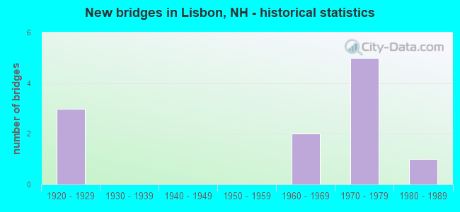
- New bridges - historical statistics
- 31920-1929
- 21960-1969
- 51970-1979
- 11980-1989

- Reconstructed bridges - Historical Statistics
- 11970-1979
- 21980-1989
- 01990-1999
- 12000-2009
- 12010-2019


- Bridge Condition - Deck
- 10.0%Very good
- 30.0%Good
- 30.0%Satisfactory
- 20.0%Fair
- 10.0%Poor

- Bridge Condition - Superstructure
- 30.0%Good
- 30.0%Satisfactory
- 30.0%Fair
- 10.0%Poor

- Bridge Condition - Substructure
- 40.0%Good
- 50.0%Satisfactory
- 10.0%Fair

- Bridge Condition - Channel
- 20.0%Good
- 80.0%Satisfactory
Find on map >> Show street view
Structure Number: 150006300078, Location: 214 FT FROM NH RTE 112 (Lat: 44.214278, Lng: -71.910964), Route carried "on" structure: Other road , Year Built: 1960, Year Reconstructed: 1986, Status: Open, Structure Length: 6.77m (22.21ft), Average Daily Traffic: 1,566 (year 2020), Truck Traffic: 4%, Average Future Daily Traffic: 2,317 (year 2042), Design Load: H 20, Features Intersected: AMMONOOSUC RIVER, Facility Carried by Structure: SCHOOL STREET
Minimum Vertical Clearance: 30+ m (98+ ft), Kilometerpoint: 0.069, Lanes on structure: 2, Owner: City or Municipal Highway Agency, Approaching Roadway Width: 8.5m (27.9ft), Material/Design: Steel, Design/Construction: Stringer/Multi-beam, Number Of Spans In Main Unit: 3, Length of Maximum Span: 23.5m (77.1ft), Curb or Sidewalk Widths: Left: 0.2m (0.7ft), Right: 1.6m (5.2ft), Curb-To-Curb Width: 8.6m (28.2ft), Out-to-Out Width: 11.0m (36.1ft)
Condition: Deck: Poor, Superstructure: Good, Substructure: Satisfactory, Channel: Satisfactory, Operating Rating: 61.7 metric tons, Method Used To Determine Operating Rating: Load Factor (LF), Inventory Rating: 38.1 metric tons, Method Used To Determine Inventory Rating: Load Factor (LF), Structural Evaluation: Equal to present minimum criteria, Deck Geometry: Somewhat better than minimum adequacy, Waterway Adequacy: Equal to present desirable criteria, Approach Roadway Alignment: Equal to present desirable criteria, Length Of Structure Improvement: 6.77m (22.21ft), Designated Inspection Frequency: Every 16 months, Inspection Date: October 2021, Bridge Improvement Cost: $2,718,000, Roadway Improvement Cost: $200,000, Total Project Cost: $3,142,000 ( Estimate for 2022), Deck Structure Type: Concrete Cast-file-Place, Wearing Surface/Protective System: Wearing Surface: Bituminous
Find on map >> Show street view
Structure Number: 150008200076, Location: 0.7 MI FR NH RTE 112 (Lat: 44.211906, Lng: -71.894092), Route carried "on" structure: Other road , Year Built: 1928, Status: Open, Structure Length: 0.91m (2.99ft), Average Daily Traffic: 1,098 (year 2020), Truck Traffic: 10%, Average Future Daily Traffic: 1,625 (year 2042), Design Load: H 15, Features Intersected: PEARL LAKE BROOK, Facility Carried by Structure: PEARL LAKE ROAD
Minimum Vertical Clearance: 30+ m (98+ ft), Kilometerpoint: 1.147, Lanes on structure: 2, Owner: City or Municipal Highway Agency, Approaching Roadway Width: 5.5m (18.0ft), Skew: 4 degrees, Material/Design: Concrete, Design/Construction: Arch - Deck, Number Of Spans In Main Unit: 1, Length of Maximum Span: 9.1m (29.9ft), Curb-To-Curb Width: 6.6m (21.7ft), Out-to-Out Width: 7.1m (23.3ft)
Condition: Deck: Fair, Superstructure: Fair, Substructure: Fair, Channel: Satisfactory, Operating Rating: 24.5 metric tons, Method Used To Determine Operating Rating: Load Factor (LF), Inventory Rating: 17.2 metric tons, Method Used To Determine Inventory Rating: Load Factor (LF), Structural Evaluation: Meets minimum limits, Deck Geometry: High priority of replacement, Waterway Adequacy: Equal to present minimum criteria, Approach Roadway Alignment: Equal to present minimum criteria, Length Of Structure Improvement: 0.91m (2.99ft), Designated Inspection Frequency: Every 24 months, Inspection Date: September 2020, Bridge Improvement Cost: $2,718,000, Roadway Improvement Cost: $200,000, Total Project Cost: $3,142,000 ( Estimate for 2022), Deck Structure Type: Concrete Cast-file-Place, Wearing Surface/Protective System: Wearing Surface: Bituminous
Find on map >> Show street view
Structure Number: 150008300132, Location: 1.09 MI NW JCT 302 (Lat: 44.247194, Lng: -71.889600), Route carried "on" structure: State highway , Year Built: 1928, Year Reconstructed: 1982, Status: Open, Structure Length: 0.61m (2.00ft), Average Daily Traffic: 1,098 (year 2020), Truck Traffic: 10%, Average Future Daily Traffic: 1,625 (year 2042), Design Load: H 15, Features Intersected: MILL BROOK, Facility Carried by Structure: LYMAN ROAD
Minimum Vertical Clearance: 30+ m (98+ ft), Kilometerpoint: 1.386, Lanes on structure: 2, Owner: State Highway Agency, Approaching Roadway Width: 6.4m (21.0ft), Material/Design: Concrete, Design/Construction: Arch - Deck, Number Of Spans In Main Unit: 1, Length of Maximum Span: 6.1m (20.0ft), Curb-To-Curb Width: 7.3m (24.0ft), Out-to-Out Width: 8.4m (27.6ft)
Condition: Deck: Good, Superstructure: Good, Substructure: Good, Channel: Satisfactory, Operating Rating: 44.9 metric tons, Method Used To Determine Operating Rating: Load Factor (LF), Inventory Rating: 26.9 metric tons, Method Used To Determine Inventory Rating: Load Factor (LF), Structural Evaluation: Equal to present minimum criteria, Deck Geometry: Meets minimum limits, Waterway Adequacy: Better than present minimum criteria, Approach Roadway Alignment: Equal to present desirable criteria, Length Of Structure Improvement: 0.61m (2.00ft), Designated Inspection Frequency: Every 24 months, Inspection Date: April 2020, Bridge Improvement Cost: $2,718,000, Roadway Improvement Cost: $200,000, Total Project Cost: $3,142,000 ( Estimate for 2022), Deck Structure Type: Concrete Cast-file-Place, Wearing Surface/Protective System: Wearing Surface: Bituminous
Find on map >> Show street view
Structure Number: 150008800125, Location: 1.0 MI FROM LYMAN TL (Lat: 44.244672, Lng: -71.888283), Route carried "on" structure: Other road , Year Built: 1975, Status: Open, Structure Length: 0.82m (2.69ft), Average Daily Traffic: 81 (year 2020), Average Future Daily Traffic: 119 (year 2042), Features Intersected: MILL BROOK, Facility Carried by Structure: PLAINS ROAD
Minimum Vertical Clearance: 30+ m (98+ ft), Kilometerpoint: 0.019, Lanes on structure: 2, Owner: City or Municipal Highway Agency, Approaching Roadway Width: 5.5m (18.0ft), Material/Design: Steel, Design/Construction: Stringer/Multi-beam, Number Of Spans In Main Unit: 1, Length of Maximum Span: 7.6m (24.9ft), Curb-To-Curb Width: 6.5m (21.3ft), Out-to-Out Width: 6.7m (22.0ft)
Condition: Deck: Satisfactory, Superstructure: Poor, Substructure: Satisfactory, Channel: Satisfactory, Operating Rating: 22.9 metric tons, Method Used To Determine Operating Rating: Allowable Stress (AS), Inventory Rating: 16.3 metric tons, Method Used To Determine Inventory Rating: Allowable Stress (AS), Structural Evaluation: Meets minimum limits, Deck Geometry: Somewhat better than minimum adequacy, Waterway Adequacy: Equal to present desirable criteria, Approach Roadway Alignment: Equal to present desirable criteria, Length Of Structure Improvement: 0.82m (2.69ft), Designated Inspection Frequency: Every 16 months, Inspection Date: October 2021, Bridge Improvement Cost: $2,718,000, Roadway Improvement Cost: $200,000, Total Project Cost: $3,142,000 ( Estimate for 2022), Deck Structure Type: Concrete Cast-file-Place, Wearing Surface/Protective System: Wearing Surface: Bituminous
Find on map >> Show street view
Structure Number: 150009000118, Location: 1.3 MI FROM LYMAN TL (Lat: 44.243231, Lng: -71.884331), Route carried "on" structure: Other road , Year Built: 1970, Status: Open, Structure Length: 0.73m (2.40ft), Average Daily Traffic: 106 (year 2020), Truck Traffic: 4%, Average Future Daily Traffic: 156 (year 2042), Features Intersected: MILL BROOK, Facility Carried by Structure: BISHOP ROAD
Minimum Vertical Clearance: 30+ m (98+ ft), Kilometerpoint: 3.225, Lanes on structure: 2, Owner: City or Municipal Highway Agency, Approaching Roadway Width: 4.9m (16.1ft), Material/Design: Steel, Design/Construction: Stringer/Multi-beam, Number Of Spans In Main Unit: 1, Length of Maximum Span: 6.4m (21.0ft), Curb-To-Curb Width: 5.8m (19.0ft), Out-to-Out Width: 6.4m (21.0ft)
Condition: Deck: Fair, Superstructure: Fair, Substructure: Satisfactory, Channel: Satisfactory, Operating Rating: 22.9 metric tons, Method Used To Determine Operating Rating: Allowable Stress (AS), Inventory Rating: 16.3 metric tons, Method Used To Determine Inventory Rating: Allowable Stress (AS), Structural Evaluation: Somewhat better than minimum adequacy, Deck Geometry: High priority of corrective action, Waterway Adequacy: Somewhat better than minimum adequacy, Approach Roadway Alignment: Equal to present desirable criteria, Length Of Structure Improvement: 0.73m (2.40ft), Designated Inspection Frequency: Every 24 months, Inspection Date: September 2020, Bridge Improvement Cost: $2,718,000, Roadway Improvement Cost: $200,000, Total Project Cost: $3,142,000 ( Estimate for 2022), Deck Structure Type: Concrete Cast-file-Place, Wearing Surface/Protective System: Wearing Surface: Bituminous
Find on map >> Show street view
Structure Number: 150009000121, Location: .59 MI N.W. JCT. 302 (Lat: 44.243992, Lng: -71.886228), Route carried "on" structure: State highway , Year Built: 1974, Status: Open, Structure Length: 0.91m (2.99ft), Average Daily Traffic: 759 (year 2020), Truck Traffic: 10%, Average Future Daily Traffic: 1,123 (year 2042), Design Load: HS 20, Features Intersected: MILL BROOK, Facility Carried by Structure: LYMAN ROAD
Minimum Vertical Clearance: 30+ m (98+ ft), Kilometerpoint: 0.866, Lanes on structure: 2, Owner: State Highway Agency, Approaching Roadway Width: 6.4m (21.0ft), Skew: 2 degrees, Material/Design: Concrete, Design/Construction: Frame, Number Of Spans In Main Unit: 1, Length of Maximum Span: 8.2m (26.9ft), Curb or Sidewalk Widths: Left: 0.1m (0.3ft), Right: 0.1m (0.3ft), Curb-To-Curb Width: 8.9m (29.2ft), Out-to-Out Width: 9.9m (32.5ft)
Condition: Deck: Good, Superstructure: Good, Substructure: Good, Channel: Good, Operating Rating: 52.4 metric tons, Method Used To Determine Operating Rating: Load Factor (LF), Inventory Rating: 31.5 metric tons, Method Used To Determine Inventory Rating: Load Factor (LF), Structural Evaluation: Better than present minimum criteria, Deck Geometry: Somewhat better than minimum adequacy, Waterway Adequacy: Equal to present desirable criteria, Approach Roadway Alignment: Equal to present desirable criteria, Length Of Structure Improvement: 0.91m (2.99ft), Designated Inspection Frequency: Every 24 months, Inspection Date: April 2020, Bridge Improvement Cost: $2,718,000, Roadway Improvement Cost: $200,000, Total Project Cost: $3,142,000 ( Estimate for 2022), Deck Structure Type: Concrete Cast-file-Place, Wearing Surface/Protective System: Wearing Surface: Integral Concrete
Find on map >> Show street view
Structure Number: 150009400112, Location: 2.9 MI LANDAFF TL (Lat: 44.237403, Lng: -71.881208), Route carried "on" structure: US 302, Year Built: 1979, Year Reconstructed: 2016, Status: Open, Structure Length: 1.95m (6.40ft), Average Daily Traffic: 4,772 (year 2020), Truck Traffic: 7%, Average Future Daily Traffic: 7,062 (year 2042), Design Load: HS 20+Mod, Features Intersected: NHRR(ABD)
Minimum Vertical Clearance: 30+ m (98+ ft), Kilometerpoint: 20.967, Lanes on structure: 2, Owner: State Highway Agency, Approaching Roadway Width: 12.8m (42.0ft), Skew: 3 degrees, Material/Design: Steel, Design/Construction: Stringer/Multi-beam, Number Of Spans In Main Unit: 1, Length of Maximum Span: 17.4m (57.1ft), Curb or Sidewalk Widths: Left: 0.2m (0.7ft), Right: 0.2m (0.7ft), Curb-To-Curb Width: 13.0m (42.7ft), Out-to-Out Width: 14.2m (46.6ft)
Condition: Deck: Good, Superstructure: Satisfactory, Substructure: Good, Operating Rating: 44.5 metric tons, Method Used To Determine Operating Rating: Load Factor (LF), Inventory Rating: 32.7 metric tons, Method Used To Determine Inventory Rating: Load Factor (LF), Structural Evaluation: Equal to present minimum criteria, Deck Geometry: Equal to present minimum criteria, Underclear: Better than present minimum criteria, Approach Roadway Alignment: Equal to present desirable criteria, Length Of Structure Improvement: 1.95m (6.40ft), Designated Inspection Frequency: Every 24 months, Inspection Date: August 2020, Bridge Improvement Cost: $2,718,000, Roadway Improvement Cost: $200,000, Total Project Cost: $3,142,000 ( Estimate for 2022), Deck Structure Type: Concrete Cast-file-Place, Wearing Surface/Protective System: Wearing Surface: Bituminous, Membrane: Preformed Fabric
Find on map >> Show street view
Structure Number: 150009400114, Location: 2.9 MI LANDAFF TL (Lat: 44.237969, Lng: -71.880156), Route carried "on" structure: US 302, Year Built: 1980, Year Reconstructed: 2009, Status: Open, Structure Length: 9.27m (30.41ft), Average Daily Traffic: 4,772 (year 2020), Truck Traffic: 7%, Average Future Daily Traffic: 7,062 (year 2042), Design Load: HS 20+Mod, Features Intersected: AMMONOOSUC RIVER
Minimum Vertical Clearance: 30+ m (98+ ft), Kilometerpoint: 21.074, Lanes on structure: 2, Owner: State Highway Agency, Approaching Roadway Width: 12.8m (42.0ft), Material/Design: Steel continuous, Design/Construction: Stringer/Multi-beam, Number Of Spans In Main Unit: 3, Length of Maximum Span: 34.7m (113.8ft), Curb or Sidewalk Widths: Left: 0.2m (0.7ft), Right: 0.2m (0.7ft), Curb-To-Curb Width: 13.0m (42.7ft), Out-to-Out Width: 14.2m (46.6ft)
Condition: Deck: Very good, Superstructure: Satisfactory, Substructure: Good, Channel: Satisfactory, Operating Rating: 25.1 metric tons, Method Used To Determine Operating Rating: Load Factor (LF), Inventory Rating: 15.1 metric tons, Method Used To Determine Inventory Rating: Load Factor (LF), Structural Evaluation: Meets minimum limits, Deck Geometry: Equal to present minimum criteria, Waterway Adequacy: Superior to present desirable criteria, Approach Roadway Alignment: Equal to present desirable criteria, Length Of Structure Improvement: 9.27m (30.41ft), Designated Inspection Frequency: Every 24 months, Inspection Date: August 2020, Bridge Improvement Cost: $2,718,000, Roadway Improvement Cost: $200,000, Total Project Cost: $3,142,000 ( Estimate for 2022), Deck Structure Type: Concrete Cast-file-Place, Wearing Surface/Protective System: Wearing Surface: Bituminous, Membrane: Other, Deck Protection: Epoxy Coated Reinforcing
Find on map >> Show street view
Structure Number: 150010100112, Location: 0.3 MI FROM NH RTE 117 (Lat: 44.237578, Lng: -71.875778), Route carried "on" structure: Other road , Year Built: 1920, Year Reconstructed: 1980, Status: Open, Structure Length: 1.01m (3.31ft), Average Daily Traffic: 230 (year 2020), Average Future Daily Traffic: 340 (year 2042), Features Intersected: SALMON HOLE BROOK, Facility Carried by Structure: RIVER ROAD
Minimum Vertical Clearance: 30+ m (98+ ft), Kilometerpoint: 0.507, Lanes on structure: 2, Owner: City or Municipal Highway Agency, Approaching Roadway Width: 4.9m (16.1ft), Material/Design: Steel, Design/Construction: Stringer/Multi-beam, Number Of Spans In Main Unit: 1, Length of Maximum Span: 6.7m (22.0ft), Curb or Sidewalk Widths: Left: 0.2m (0.7ft), Right: 0.2m (0.7ft), Curb-To-Curb Width: 6.1m (20.0ft), Out-to-Out Width: 6.4m (21.0ft)
Condition: Deck: Satisfactory, Superstructure: Satisfactory, Substructure: Satisfactory, Channel: Satisfactory, Operating Rating: 24.5 metric tons, Method Used To Determine Operating Rating: Allowable Stress (AS), Inventory Rating: 16.3 metric tons, Method Used To Determine Inventory Rating: Allowable Stress (AS), Structural Evaluation: Somewhat better than minimum adequacy, Deck Geometry: Meets minimum limits, Waterway Adequacy: Better than present minimum criteria, Approach Roadway Alignment: Equal to present desirable criteria, Length Of Structure Improvement: 1.01m (3.31ft), Designated Inspection Frequency: Every 24 months, Inspection Date: October 2021, Bridge Improvement Cost: $2,718,000, Roadway Improvement Cost: $200,000, Total Project Cost: $3,142,000 ( Estimate for 2022), Deck Structure Type: Concrete Cast-file-Place, Wearing Surface/Protective System: Wearing Surface: Bituminous
Find on map >> Show street view
Structure Number: 150011600108, Location: 1.0 MI E. JCT. RT. 302 (Lat: 44.233647, Lng: -71.860564), Route carried "on" structure: State highway 117, Year Built: 1969, Status: Open, Structure Length: 1.07m (3.51ft), Average Daily Traffic: 802 (year 2020), Truck Traffic: 4%, Average Future Daily Traffic: 1,186 (year 2042), Design Load: HS 20, Features Intersected: SALMON HOLE BROOK
Minimum Vertical Clearance: 30+ m (98+ ft), Kilometerpoint: 1.836, Lanes on structure: 2, Owner: State Highway Agency, Approaching Roadway Width: 9.8m (32.2ft), Skew: 4 degrees, Material/Design: Concrete, Design/Construction: Culvert, Number Of Spans In Main Unit: 1, Length of Maximum Span: 10.7m (35.1ft)
Condition: Channel: Good, Culverts: Good, Operating Rating: 54.4 metric tons, Method Used To Determine Operating Rating: Load Factor (LF), Inventory Rating: 32.7 metric tons, Method Used To Determine Inventory Rating: Load Factor (LF), Structural Evaluation: Better than present minimum criteria, Waterway Adequacy: Superior to present desirable criteria, Approach Roadway Alignment: Equal to present desirable criteria, Length Of Structure Improvement: 1.07m (3.51ft), Designated Inspection Frequency: Every 24 months, Inspection Date: April 2020, Bridge Improvement Cost: $2,718,000, Roadway Improvement Cost: $200,000, Total Project Cost: $3,142,000 ( Estimate for 2022)
Find on map >> Show street view
Structure Number: 1500123001, Location: 0.3 MI FROM GULF RD NO 6 (Lat: 44.228361, Lng: -71.852322), Route carried "on" structure: Other road , Year Built: 1975, Status: Open, Structure Length: 0.70m (2.30ft), Average Daily Traffic: 81 (year 2020), Average Future Daily Traffic: 119 (year 2042), Features Intersected: SALMON HOLE BROOK, Facility Carried by Structure: BREEZY HILL ROAD
Minimum Vertical Clearance: 30+ m (98+ ft), Kilometerpoint: 0.597, Lanes on structure: 2, Owner: City or Municipal Highway Agency, Approaching Roadway Width: 4.3m (14.1ft), Skew: 1 degrees, Material/Design: Steel, Design/Construction: Stringer/Multi-beam, Number Of Spans In Main Unit: 1, Length of Maximum Span: 6.4m (21.0ft), Curb-To-Curb Width: 5.2m (17.1ft), Out-to-Out Width: 5.5m (18.0ft)
Condition: Deck: Satisfactory, Superstructure: Fair, Substructure: Satisfactory, Channel: Satisfactory, Operating Rating: 22.9 metric tons, Method Used To Determine Operating Rating: Allowable Stress (AS), Inventory Rating: 16.3 metric tons, Method Used To Determine Inventory Rating: Allowable Stress (AS), Structural Evaluation: Somewhat better than minimum adequacy, Deck Geometry: High priority of corrective action, Waterway Adequacy: Better than present minimum criteria, Approach Roadway Alignment: Equal to present desirable criteria, Length Of Structure Improvement: 0.70m (2.30ft), Designated Inspection Frequency: Every 24 months, Inspection Date: September 2020, Bridge Improvement Cost: $2,718,000, Roadway Improvement Cost: $200,000, Total Project Cost: $3,142,000 ( Estimate for 2022), Deck Structure Type: Concrete Cast-file-Place, Wearing Surface/Protective System: Wearing Surface: Bituminous