Bridge Statistics for Lititz, Pennsylvania (PA)
Condition, Traffic, Stress, Structural Evaluation, Project Costs
- National Bridge Inventory (NBI) Statistics
- 14Number of bridges
- 43ft / 13.1mTotal length
- $1,045,000Total costs
- 39,703Total average daily traffic
- 2,264Total average daily truck traffic
- 51,756Total future (year 2026) average daily traffic
- National Bridge Inventory (NBI) Registered Bridges for Lititz
- No street view available for this location
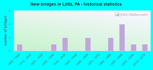
- New bridges - historical statistics
- 11900-1909
- 11930-1939
- 21940-1949
- 21960-1969
- 21980-1989
- 41990-1999
- 12000-2009
- 12010-2019

- Reconstructed bridges - Historical Statistics
- 11950-1959
- 01960-1969
- 01970-1979
- 01980-1989
- 01990-1999
- 12000-2009
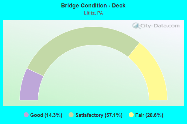
- Bridge Condition - Deck
- 14.3%Good
- 57.1%Satisfactory
- 28.6%Fair
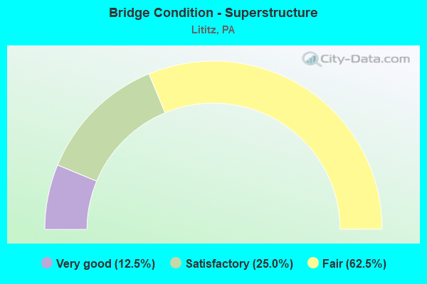
- Bridge Condition - Superstructure
- 12.5%Very good
- 25.0%Satisfactory
- 62.5%Fair
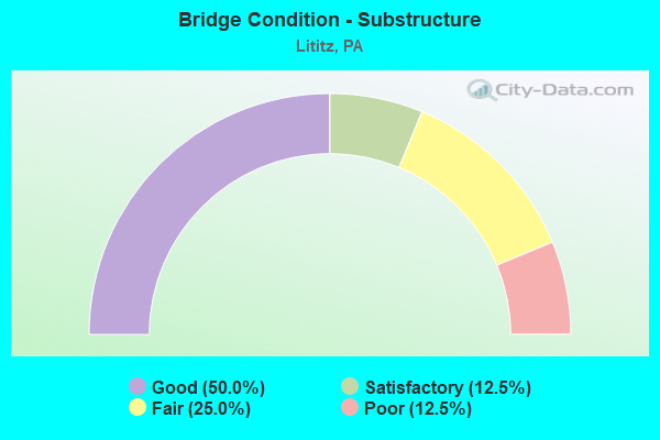
- Bridge Condition - Substructure
- 50.0%Good
- 12.5%Satisfactory
- 25.0%Fair
- 12.5%Poor
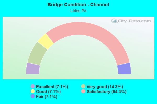
- Bridge Condition - Channel
- 7.1%Excellent
- 14.3%Very good
- 7.1%Good
- 64.3%Satisfactory
- 7.1%Fair
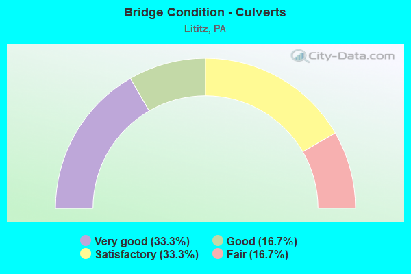
- Bridge Condition - Culverts
- 33.3%Very good
- 16.7%Good
- 33.3%Satisfactory
- 16.7%Fair
Find on map >> Show street view
Structure Number: 2144, Location: DG08 DOUGLAS RUN # 8 (Lat: 40.241522, Lng: -79.839500), Route carried "on" structure: County highway , Year Built: 1901, Year Reconstructed: 1950, Status: Open, Structure Length: 0.64m (2.10ft), Average Daily Traffic: 3,288 (year 2004), Truck Traffic: 5%, Average Future Daily Traffic: 4,000 (year 2030), Features Intersected: DOUGLAS RUN, BRANCH, Facility Carried by Structure: ROUND HILL RD
Minimum Vertical Clearance: 30+ m (98+ ft), Kilometerpoint: 0.000, Lanes on structure: 2, Owner: County Highway Agency, Approaching Roadway Width: 8.5m (27.9ft), Skew: 4 degrees, Material/Design: Concrete continuous, Design/Construction: Stringer/Multi-beam, Number Of Spans In Main Unit: 1, Length of Maximum Span: 5.2m (17.1ft), Curb-To-Curb Width: 25.3m (83.0ft), Out-to-Out Width: 26.2m (86.0ft)
Condition: Superstructure: Satisfactory, Substructure: Satisfactory, Channel: Satisfactory, Operating Rating: 53.5 metric tons, Method Used To Determine Operating Rating: Field evaluation and documented engineering judgment, Inventory Rating: 31.8 metric tons, Method Used To Determine Inventory Rating: Field evaluation and documented engineering judgment, Structural Evaluation: Equal to present minimum criteria, Deck Geometry: Superior to present desirable criteria, Waterway Adequacy: Equal to present desirable criteria, Approach Roadway Alignment: Equal to present desirable criteria, Length Of Structure Improvement: 0.60m (1.97ft), Designated Inspection Frequency: Every 24 months, Inspection Date: November 2020, Bridge Improvement Cost: $6,000, Roadway Improvement Cost: $25,000, Total Project Cost: $82,000, Wearing Surface/Protective System: Wearing Surface: Bituminous
Find on map >> Show street view
Structure Number: 21286, Location: 0.25 MI.N. OF LITITZ BORO (Lat: 40.168119, Lng: -76.308181), Route carried "on" structure: State highway 501, Year Built: 1934, Status: Open, Structure Length: 0.85m (2.79ft), Average Daily Traffic: 13,522 (year 2022), Truck Traffic: 7%, Average Future Daily Traffic: 18,601 (year 2032), Design Load: H 20, Features Intersected: LITITZ RUN
Minimum Vertical Clearance: 30+ m (98+ ft), Kilometerpoint: 11.796, Lanes on structure: 2, Owner: State Highway Agency, Approaching Roadway Width: 11.3m (37.1ft), Skew: 1 degrees, Material/Design: Concrete, Design/Construction: Tee Beam, Number Of Spans In Main Unit: 1, Length of Maximum Span: 7.6m (24.9ft), Curb-To-Curb Width: 9.4m (30.8ft), Out-to-Out Width: 10.6m (34.8ft)
Condition: Deck: Satisfactory, Superstructure: Fair, Substructure: Fair, Channel: Fair, Operating Rating: 64.4 metric tons, Method Used To Determine Operating Rating: Load Factor (LF), Inventory Rating: 39.0 metric tons, Method Used To Determine Inventory Rating: Load Factor (LF), Structural Evaluation: Somewhat better than minimum adequacy, Deck Geometry: High priority of corrective action, Waterway Adequacy: Equal to present minimum criteria, Approach Roadway Alignment: Equal to present desirable criteria, Length Of Structure Improvement: 1.50m (4.92ft), Designated Inspection Frequency: Every 24 months, Inspection Date: March 2021, Bridge Improvement Cost: $8,000, Roadway Improvement Cost: $22,000, Total Project Cost: $103,000, Deck Structure Type: Concrete Cast-file-Place, Wearing Surface/Protective System: Wearing Surface: Bituminous, Membrane: Preformed Fabric
Find on map >> Show street view
Structure Number: 2144, Location: LITITZ BORO (Lat: 40.157225, Lng: -76.301894), Route carried "on" structure: State highway , Year Built: 1995, Status: Open, Structure Length: 0.76m (2.49ft), Average Daily Traffic: 961 (year 2021), Truck Traffic: 5%, Average Future Daily Traffic: 1,831 (year 2032), Design Load: HS 25 or greater, Features Intersected: LITITZ RUN, Facility Carried by Structure: SR 1035
Minimum Vertical Clearance: 30+ m (98+ ft), Kilometerpoint: 0.000, Lanes on structure: 2, Owner: State Highway Agency, Approaching Roadway Width: 8.5m (27.9ft), Skew: 1 degrees, Material/Design: Prestressed concrete, Design/Construction: Slab, Number Of Spans In Main Unit: 1, Length of Maximum Span: 7.3m (24.0ft), Curb or Sidewalk Widths: Left: 1.5m (4.9ft), Right: 1.5m (4.9ft), Curb-To-Curb Width: 8.5m (27.9ft), Out-to-Out Width: 12.3m (40.4ft)
Condition: Deck: Good, Superstructure: Very good, Substructure: Good, Channel: Very good, Operating Rating: 89.8 metric tons, Method Used To Determine Operating Rating: Load Factor (LF), Inventory Rating: 58.1 metric tons, Method Used To Determine Inventory Rating: Load Factor (LF), Structural Evaluation: Better than present minimum criteria, Deck Geometry: Somewhat better than minimum adequacy, Waterway Adequacy: Equal to present minimum criteria, Approach Roadway Alignment: Equal to present desirable criteria, Length Of Structure Improvement: 1.50m (4.92ft), Designated Inspection Frequency: Every 24 months, Inspection Date: December 2020, Deck Structure Type: Concrete Cast-file-Place, Wearing Surface/Protective System: Wearing Surface: Monolithic Concrete, Deck Protection: Epoxy Coated Reinforcing
Find on map >> Show street view
Structure Number: 21441, Location: LITITZ BORO - WATER ST. (Lat: 40.161419, Lng: -76.299256), Route carried "on" structure: State highway , Year Built: 1995, Status: Open, Structure Length: 1.10m (3.61ft), Average Daily Traffic: 961 (year 2021), Truck Traffic: 5%, Average Future Daily Traffic: 1,831 (year 2032), Design Load: HS 25 or greater, Features Intersected: SANTO DOMINGO CREEK, Facility Carried by Structure: SR 1035 N.Water St
Minimum Vertical Clearance: 30+ m (98+ ft), Kilometerpoint: 0.000, Lanes on structure: 2, Owner: State Highway Agency, Approaching Roadway Width: 8.2m (26.9ft), Skew: 2 degrees, Material/Design: Concrete, Design/Construction: Culvert, Number Of Spans In Main Unit: 2, Length of Maximum Span: 4.9m (16.1ft), Curb or Sidewalk Widths: Left: 1.5m (4.9ft), Right: 1.5m (4.9ft), Curb-To-Curb Width: 8.5m (27.9ft), Out-to-Out Width: 12.2m (40.0ft)
Condition: Channel: Satisfactory, Culverts: Good, Operating Rating: 68.9 metric tons, Method Used To Determine Operating Rating: Load Factor (LF), Inventory Rating: 40.8 metric tons, Method Used To Determine Inventory Rating: Load Factor (LF), Structural Evaluation: Better than present minimum criteria, Deck Geometry: Somewhat better than minimum adequacy, Waterway Adequacy: Better than present minimum criteria, Approach Roadway Alignment: Equal to present desirable criteria, Length Of Structure Improvement: 1.70m (5.58ft), Designated Inspection Frequency: Every 24 months, Inspection Date: December 2020, Deck Structure Type: Concrete Cast-file-Place, Wearing Surface/Protective System: Wearing Surface: Bituminous, Deck Protection: Epoxy Coated Reinforcing
Find on map >> Show street view
Structure Number: 2145, Location: 0.2 MI. N.E. LITITZ (Lat: 40.165747, Lng: -76.284325), Route carried "on" structure: State highway , Year Built: 1985, Status: Open, Structure Length: 0.73m (2.40ft), Average Daily Traffic: 11,445 (year 2022), Truck Traffic: 8%, Average Future Daily Traffic: 12,818 (year 2032), Design Load: HS 25 or greater, Features Intersected: MOORES RUN, Facility Carried by Structure: SR 1037 Newport rd
Minimum Vertical Clearance: 30+ m (98+ ft), Kilometerpoint: 0.000, Lanes on structure: 2, Owner: State Highway Agency, Approaching Roadway Width: 6.7m (22.0ft), Skew: 5 degrees, Material/Design: Concrete, Design/Construction: Frame, Number Of Spans In Main Unit: 1, Length of Maximum Span: 6.4m (21.0ft), Curb-To-Curb Width: 7.9m (25.9ft), Out-to-Out Width: 9.1m (29.9ft)
Condition: Deck: Satisfactory, Superstructure: Satisfactory, Substructure: Good, Channel: Satisfactory, Operating Rating: 78.0 metric tons, Method Used To Determine Operating Rating: Load Factor (LF), Inventory Rating: 47.2 metric tons, Method Used To Determine Inventory Rating: Load Factor (LF), Structural Evaluation: Equal to present minimum criteria, Deck Geometry: High priority of replacement, Waterway Adequacy: Better than present minimum criteria, Approach Roadway Alignment: Equal to present desirable criteria, Length Of Structure Improvement: 1.40m (4.59ft), Designated Inspection Frequency: Every 48 months, Inspection Date: Febuary 2021, Bridge Improvement Cost: $3,000, Roadway Improvement Cost: $9,000, Total Project Cost: $42,000, Wearing Surface/Protective System: Wearing Surface: Bituminous, Deck Protection: Epoxy Coated Reinforcing
Find on map >> Show street view
Structure Number: 21824, Location: 1.3 MI NE OF SR 4011 (Lat: 40.120064, Lng: -76.315483), Route carried "on" structure: City street , Year Built: 1992, Status: Open, Structure Length: 1.46m (4.79ft), Average Daily Traffic: 520 (year 2011), Truck Traffic: 1%, Average Future Daily Traffic: 725 (year 2031), Design Load: HS 25 or greater, Features Intersected: BACHMAN RUN, Facility Carried by Structure: KOSER ROAD
Minimum Vertical Clearance: 30+ m (98+ ft), Kilometerpoint: 0.000, Lanes on structure: 2, Owner: Town or Township Highway Agency, Approaching Roadway Width: 11.6m (38.1ft), Skew: 1 degrees, Material/Design: Concrete, Design/Construction: Culvert, Number Of Spans In Main Unit: 4, Length of Maximum Span: 3.0m (9.8ft), Curb or Sidewalk Widths: Left: 2.1m (6.9ft), Right: 2.1m (6.9ft), Curb-To-Curb Width: 11.0m (36.1ft), Out-to-Out Width: 17.3m (56.8ft)
Condition: Channel: Very good, Culverts: Satisfactory, Operating Rating: 82.6 metric tons, Method Used To Determine Operating Rating: Load Factor (LF), Inventory Rating: 49.0 metric tons, Method Used To Determine Inventory Rating: Load Factor (LF), Structural Evaluation: Equal to present minimum criteria, Deck Geometry: Better than present minimum criteria, Waterway Adequacy: Better than present minimum criteria, Approach Roadway Alignment: Equal to present desirable criteria, Length Of Structure Improvement: 2.10m (6.89ft), Designated Inspection Frequency: Every 24 months, Inspection Date: December 2019
Find on map >> Show street view
Structure Number: 22105, Location: 150 FT NE OF SR 772 (Lat: 40.150492, Lng: -76.283675), Route carried "on" structure: City street , Year Built: 1990, Status: Open, Structure Length: 1.55m (5.09ft), Average Daily Traffic: 100 (year 2011), Truck Traffic: 1%, Average Future Daily Traffic: 135 (year 2031), Design Load: HS 25 or greater, Features Intersected: LITITZ RUN, Facility Carried by Structure: T-598 CLAY RD
Minimum Vertical Clearance: 30+ m (98+ ft), Kilometerpoint: 0.000, Lanes on structure: 2, Owner: Town or Township Highway Agency, Approaching Roadway Width: 8.2m (26.9ft), Material/Design: Prestressed concrete, Design/Construction: Box Beam or Girders - Multiple, Number Of Spans In Main Unit: 1, Length of Maximum Span: 14.9m (48.9ft), Curb or Sidewalk Widths: Left: 0.2m (0.7ft), Right: 0.2m (0.7ft), Curb-To-Curb Width: 7.3m (24.0ft), Out-to-Out Width: 8.4m (27.6ft)
Condition: Deck: Satisfactory, Superstructure: Fair, Substructure: Good, Channel: Satisfactory, Operating Rating: 45.4 metric tons, Method Used To Determine Operating Rating: Load Factor (LF), Inventory Rating: 21.8 metric tons, Method Used To Determine Inventory Rating: Load Factor (LF), Structural Evaluation: Somewhat better than minimum adequacy, Deck Geometry: Equal to present minimum criteria, Waterway Adequacy: Better than present minimum criteria, Approach Roadway Alignment: Somewhat better than minimum adequacy, Length Of Structure Improvement: 0.40m (1.31ft), Designated Inspection Frequency: Every 24 months, Inspection Date: June 2021, Bridge Improvement Cost: $38,000, Roadway Improvement Cost: $113,000, Total Project Cost: $516,000, Deck Structure Type: Concrete Cast-file-Place, Wearing Surface/Protective System: Wearing Surface: Monolithic Concrete, Deck Protection: Epoxy Coated Reinforcing
Find on map >> Show street view
Structure Number: 22156, Location: 1300 FT N OF SR 772 (Lat: 40.157722, Lng: -76.303997), Route carried "on" structure: City street , Year Built: 1940, Status: Open, Structure Length: 0.79m (2.59ft), Average Daily Traffic: 3,180 (year 2011), Truck Traffic: 1%, Average Future Daily Traffic: 4,260 (year 2031), Features Intersected: LITITZ RUN, Facility Carried by Structure: CEDAR STREET
Minimum Vertical Clearance: 30+ m (98+ ft), Kilometerpoint: 0.000, Lanes on structure: 2, Owner: City or Municipal Highway Agency, Approaching Roadway Width: 9.1m (29.9ft), Skew: 1 degrees, Material/Design: Concrete continuous, Design/Construction: Stringer/Multi-beam, Number Of Spans In Main Unit: 2, Length of Maximum Span: 4.9m (16.1ft), Curb or Sidewalk Widths: Left: 2.1m (6.9ft), Right: 2.4m (7.9ft), Curb-To-Curb Width: 8.9m (29.2ft), Out-to-Out Width: 13.4m (44.0ft)
Condition: Deck: Fair, Superstructure: Fair, Substructure: Poor, Channel: Satisfactory, Operating Rating: 49.0 metric tons, Method Used To Determine Operating Rating: Field evaluation and documented engineering judgment, Inventory Rating: 32.7 metric tons, Method Used To Determine Inventory Rating: Field evaluation and documented engineering judgment, Structural Evaluation: Meets minimum limits, Deck Geometry: Meets minimum limits, Waterway Adequacy: Better than present minimum criteria, Approach Roadway Alignment: Equal to present desirable criteria, Length Of Structure Improvement: 0.80m (2.62ft), Designated Inspection Frequency: Every 24 months, Inspection Date: September 2021, Bridge Improvement Cost: $9,000, Roadway Improvement Cost: $27,000, Total Project Cost: $124,000, Deck Structure Type: Concrete Cast-file-Place, Wearing Surface/Protective System: Wearing Surface: Bituminous
Find on map >> Show street view
Structure Number: 22157, Location: 1800 FT E OF BROAD STREET (Lat: 40.163161, Lng: -76.301803), Route carried "on" structure: City street , Year Built: 1960, Status: Open, Structure Length: 0.85m (2.79ft), Average Daily Traffic: 210 (year 2011), Average Future Daily Traffic: 280 (year 2031), Features Intersected: SANTO DOMINGO CREEK, Facility Carried by Structure: EAST MARKET STREET
Minimum Vertical Clearance: 30+ m (98+ ft), Kilometerpoint: 0.000, Lanes on structure: 2, Owner: City or Municipal Highway Agency, Approaching Roadway Width: 9.1m (29.9ft), Skew: 3 degrees, Material/Design: Concrete, Design/Construction: Culvert, Number Of Spans In Main Unit: 1, Length of Maximum Span: 6.1m (20.0ft), Curb or Sidewalk Widths: Left: 1.9m (6.2ft), Right: 1.9m (6.2ft), Curb-To-Curb Width: 9.1m (29.9ft), Out-to-Out Width: 13.0m (42.7ft)
Condition: Channel: Satisfactory, Culverts: Satisfactory, Operating Rating: 49.0 metric tons, Method Used To Determine Operating Rating: Field evaluation and documented engineering judgment, Inventory Rating: 32.7 metric tons, Method Used To Determine Inventory Rating: Field evaluation and documented engineering judgment, Structural Evaluation: Equal to present minimum criteria, Deck Geometry: Equal to present minimum criteria, Waterway Adequacy: Equal to present desirable criteria, Approach Roadway Alignment: Equal to present desirable criteria, Length Of Structure Improvement: 0.90m (2.95ft), Designated Inspection Frequency: Every 24 months, Inspection Date: September 2021, Wearing Surface/Protective System: Wearing Surface: Bituminous
Find on map >> Show street view
Structure Number: 22158, Location: 1/2 MI EAST OF SR 501 (Lat: 40.157822, Lng: -76.295783), Route carried "on" structure: City street , Year Built: 1940, Year Reconstructed: 2008, Status: Open, Structure Length: 1.01m (3.31ft), Average Daily Traffic: 3,565 (year 2011), Truck Traffic: 2%, Average Future Daily Traffic: 4,760 (year 2031), Features Intersected: SANTO DOMINGO CREEK, Facility Carried by Structure: FRONT STREET
Minimum Vertical Clearance: 30+ m (98+ ft), Kilometerpoint: 0.000, Lanes on structure: 2, Owner: City or Municipal Highway Agency, Approaching Roadway Width: 10.7m (35.1ft), Skew: 2 degrees, Material/Design: Concrete continuous, Design/Construction: Stringer/Multi-beam, Number Of Spans In Main Unit: 2, Length of Maximum Span: 4.9m (16.1ft), Curb or Sidewalk Widths: Left: 2.5m (8.2ft), Right: 1.6m (5.2ft), Curb-To-Curb Width: 10.5m (34.4ft), Out-to-Out Width: 15.0m (49.2ft)
Condition: Deck: Satisfactory, Superstructure: Fair, Substructure: Fair, Channel: Satisfactory, Operating Rating: 49.0 metric tons, Method Used To Determine Operating Rating: Field evaluation and documented engineering judgment, Inventory Rating: 32.7 metric tons, Method Used To Determine Inventory Rating: Field evaluation and documented engineering judgment, Structural Evaluation: Somewhat better than minimum adequacy, Deck Geometry: Somewhat better than minimum adequacy, Waterway Adequacy: Better than present minimum criteria, Approach Roadway Alignment: Equal to present desirable criteria, Length Of Structure Improvement: 1.00m (3.28ft), Designated Inspection Frequency: Every 24 months, Inspection Date: September 2021, Bridge Improvement Cost: $13,000, Roadway Improvement Cost: $39,000, Total Project Cost: $178,000, Deck Structure Type: Concrete Cast-file-Place, Wearing Surface/Protective System: Wearing Surface: Bituminous
Find on map >> Show street view
Structure Number: 2216, Location: 300' NORTH OF S.R. 772 (Lat: 40.155339, Lng: -76.292067), Route carried "on" structure: City street , Year Built: 1968, Status: Posted for load, Structure Length: 1.04m (3.41ft), Average Daily Traffic: 1,055 (year 2011), Truck Traffic: 1%, Average Future Daily Traffic: 1,415 (year 2031), Design Load: HS 20, Features Intersected: LITITZ RUN, Facility Carried by Structure: NORTH OAK STREET
Minimum Vertical Clearance: 30+ m (98+ ft), Kilometerpoint: 0.000, Lanes on structure: 2, Owner: City or Municipal Highway Agency, Approaching Roadway Width: 8.5m (27.9ft), Material/Design: Prestressed concrete, Design/Construction: Box Beam or Girders - Multiple, Number Of Spans In Main Unit: 1, Length of Maximum Span: 9.8m (32.2ft), Curb or Sidewalk Widths: Left: 1.8m (5.9ft), Right: 1.8m (5.9ft), Curb-To-Curb Width: 8.6m (28.2ft), Out-to-Out Width: 11.4m (37.4ft)
Condition: Deck: Fair, Superstructure: Fair, Substructure: Good, Channel: Satisfactory, Operating Rating: 39.0 metric tons, Method Used To Determine Operating Rating: Load Factor (LF), Inventory Rating: 20.0 metric tons, Method Used To Determine Inventory Rating: Load Factor (LF), Structural Evaluation: Somewhat better than minimum adequacy, Deck Geometry: Somewhat better than minimum adequacy, Waterway Adequacy: Better than present minimum criteria, Approach Roadway Alignment: Equal to present desirable criteria, Bridge Posting: Required (Relationship of Operating Rating to Maximum Legal Load: 10.0 - 19.9% below), Length Of Structure Improvement: 1.10m (3.61ft), Designated Inspection Frequency: Every 24 months, Other Special Inspection Frequency: Every 12 months, Inspection Date: September 2021, Other Special Inspection Date: September 2021, Deck Structure Type: Other, Wearing Surface/Protective System: Wearing Surface: Bituminous
Find on map >> Show street view
Structure Number: 44359, Location: AT KISSEL HILL RD (Lat: 40.128156, Lng: -76.278628), Route carried "on" structure: City street , Year Built: 2007, Status: Open, Structure Length: 1.01m (3.31ft), Average Daily Traffic: 300 (year 2011), Truck Traffic: 2%, Average Future Daily Traffic: 400 (year 2031), Design Load: HS 25 or greater, Features Intersected: DRAINAGE SWALE, Facility Carried by Structure: STAUFFER ROAD
Minimum Vertical Clearance: 30+ m (98+ ft), Kilometerpoint: 0.000, Lanes on structure: 2, Owner: Town or Township Highway Agency, Approaching Roadway Width: 7.3m (24.0ft), Material/Design: Concrete, Design/Construction: Culvert, Number Of Spans In Main Unit: 3, Length of Maximum Span: 3.0m (9.8ft)
Condition: Channel: Excellent, Culverts: Very good, Operating Rating: 88.9 metric tons, Method Used To Determine Operating Rating: Load Factor (LF), Inventory Rating: 52.6 metric tons, Method Used To Determine Inventory Rating: Load Factor (LF), Structural Evaluation: Equal to present desirable criteria, Waterway Adequacy: Superior to present desirable criteria, Approach Roadway Alignment: Equal to present desirable criteria, Designated Inspection Frequency: Every 24 months, Inspection Date: January 2020
Find on map >> Show street view
Structure Number: 54581, Location: 1200 Ft N of SR 772 (Lat: 40.158719, Lng: -76.296172), Route carried "on" structure: City street , Year Built: 2017, Status: Open, Structure Length: 0.64m (2.10ft), Average Daily Traffic: 396 (year 2016), Truck Traffic: 5%, Average Future Daily Traffic: 456 (year 2026), Design Load: HL 93, Features Intersected: Santo Domingo Creek, Facility Carried by Structure: North Locust St
Minimum Vertical Clearance: 30+ m (98+ ft), Kilometerpoint: 0.000, Lanes on structure: 2, Owner: City or Municipal Highway Agency, Approaching Roadway Width: 11.3m (37.1ft), Skew: 1 degrees, Material/Design: Concrete, Design/Construction: Culvert, Number Of Spans In Main Unit: 1, Length of Maximum Span: 6.1m (20.0ft), Curb or Sidewalk Widths: Left: 2.2m (7.2ft), Right: 2.7m (8.9ft), Curb-To-Curb Width: 11.3m (37.1ft), Out-to-Out Width: 16.7m (54.8ft)
Condition: Channel: Good, Culverts: Very good, Operating Rating: 58.3 metric tons, Method Used To Determine Operating Rating: Assigned ratings based on Load and Resistance Factor Design (LRFD) reported by rating factor (RF) using HL93 loadings, Inventory Rating: 36.6 metric tons, Method Used To Determine Inventory Rating: Assigned ratings based on Load and Resistance Factor Design (LRFD) reported by rating factor (RF) using HL93 loadings, Structural Evaluation: Equal to present desirable criteria, Deck Geometry: Superior to present desirable criteria, Waterway Adequacy: Better than present minimum criteria, Approach Roadway Alignment: Equal to present desirable criteria, Designated Inspection Frequency: Every 24 months, Inspection Date: September 2021, Wearing Surface/Protective System: Wearing Surface: Bituminous, Deck Protection: Epoxy Coated Reinforcing
Find on map >> Show street view
Structure Number: 56824, Location: Btw Lititz Pk & Koser Rd (Lat: 40.117139, Lng: -76.315083), Route carried "on" structure: City street , Year Built: 1987, Status: Open, Structure Length: 0.64m (2.10ft), Average Daily Traffic: 200 (year 1987), Average Future Daily Traffic: 244 (year 2039), Design Load: HS 25 or greater, Features Intersected: Bachman Run, Facility Carried by Structure: W Airport Rd
Minimum Vertical Clearance: 30+ m (98+ ft), Kilometerpoint: 0.000, Lanes on structure: 2, Owner: Town or Township Highway Agency, Approaching Roadway Width: 10.4m (34.1ft), Skew: 1 degrees, Material/Design: Concrete, Design/Construction: Culvert, Number Of Spans In Main Unit: 1, Length of Maximum Span: 6.4m (21.0ft), Curb or Sidewalk Widths: Left: 2.4m (7.9ft), Right: 2.4m (7.9ft), Curb-To-Curb Width: 10.4m (34.1ft), Out-to-Out Width: 19.0m (62.3ft)
Condition: Channel: Satisfactory, Culverts: Fair, Operating Rating: 62.6 metric tons, Method Used To Determine Operating Rating: Load Factor (LF), Inventory Rating: 37.2 metric tons, Method Used To Determine Inventory Rating: Load Factor (LF), Structural Evaluation: Somewhat better than minimum adequacy, Deck Geometry: Better than present minimum criteria, Waterway Adequacy: Equal to present desirable criteria, Approach Roadway Alignment: Equal to present desirable criteria, Designated Inspection Frequency: Every 24 months, Inspection Date: December 2019, Wearing Surface/Protective System: Wearing Surface: Monolithic Concrete