Bridge Statistics for Little River, South Carolina (SC)
Condition, Traffic, Stress, Structural Evaluation, Project Costs
- National Bridge Inventory (NBI) Statistics
- 16Number of bridges
- 246ft / 75.4mTotal length
- $413,000Total costs
- 234,425Total average daily traffic
- 12,321Total average daily truck traffic
- National Bridge Inventory (NBI) Registered Bridges for Little River
- No street view available for this location
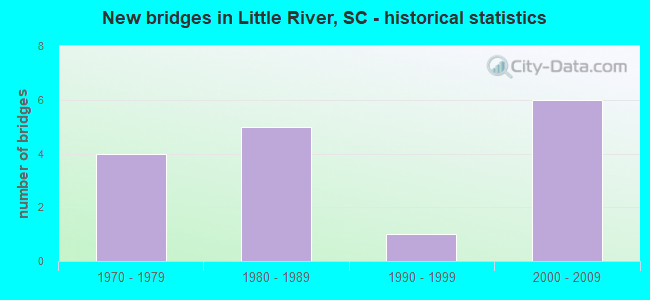
- New bridges - historical statistics
- 41970-1979
- 51980-1989
- 11990-1999
- 62000-2009
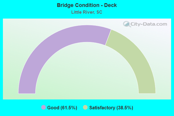
- Bridge Condition - Deck
- 61.5%Good
- 38.5%Satisfactory
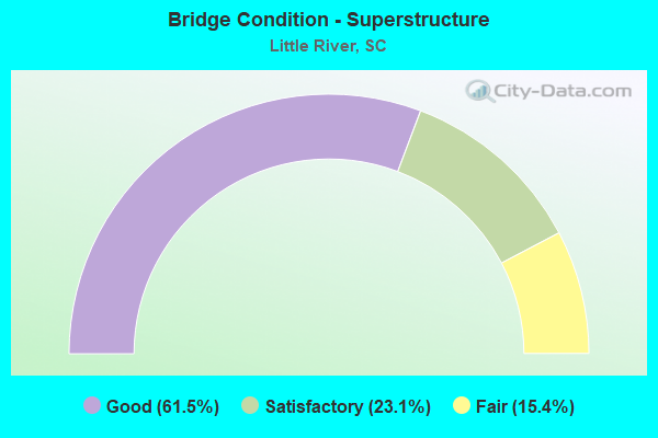
- Bridge Condition - Superstructure
- 61.5%Good
- 23.1%Satisfactory
- 15.4%Fair
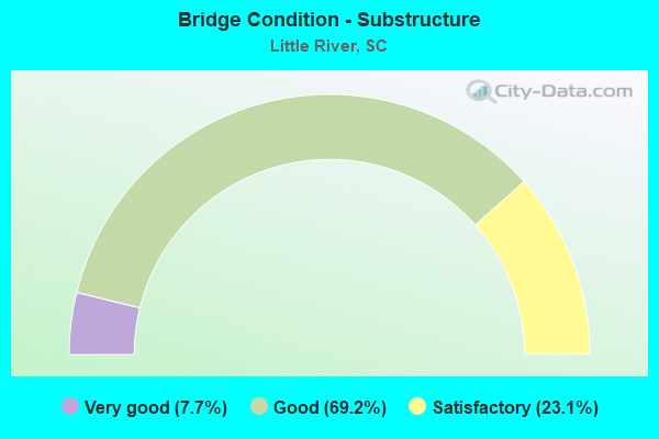
- Bridge Condition - Substructure
- 7.7%Very good
- 69.2%Good
- 23.1%Satisfactory
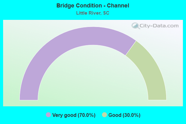
- Bridge Condition - Channel
- 70.0%Very good
- 30.0%Good
Find on map >> Show street view
Structure Number: 5758, Location: 3.0MI N OF CHERRY GROVE (Lat: 33.863158, Lng: -78.657253), Route carried "on" structure: State highway 9, Year Built: 1970, Status: Open, Structure Length: 5.70m (18.70ft), Average Daily Traffic: 21,500 (year 2020), Truck Traffic: 4%, Average Future Daily Traffic: 26,875 (year 2040), Design Load: HS 20, Features Intersected: U.S. 17 SBL
Minimum Vertical Clearance: 30+ m (98+ ft), Kilometerpoint: 63.267, Lanes on structure: 4, Lanes under structure: 2, Base Highway Network: Yes, Owner: State Highway Agency, Approaching Roadway Width: 9.8m (32.2ft), Skew: 3 degrees, Material/Design: Steel, Design/Construction: Stringer/Multi-beam, Number Of Spans In Main Unit: 3, Length of Maximum Span: 30.5m (100.1ft), Curb-To-Curb Width: 12.2m (40.0ft), Out-to-Out Width: 13.0m (42.7ft)
Condition: Deck: Satisfactory, Superstructure: Fair, Substructure: Good, Operating Rating: 50.5 metric tons, Method Used To Determine Operating Rating: Load and Resistance Factor Rating (LRFR) rating reported by rating factor(RF) method using HL-93 loadings, Inventory Rating: 39.2 metric tons, Method Used To Determine Inventory Rating: Load and Resistance Factor Rating (LRFR) rating reported by rating factor(RF) method using HL-93 loadings, Structural Evaluation: Somewhat better than minimum adequacy, Deck Geometry: High priority of replacement, Underclear: Meets minimum limits, Approach Roadway Alignment: Equal to present minimum criteria, Length Of Structure Improvement: 6.66m (21.85ft), Designated Inspection Frequency: Every 24 months, Inspection Date: September 2020, Bridge Improvement Cost: $275,000, Roadway Improvement Cost: $69,000, Total Project Cost: $413,000 ( Estimate for 2021), Deck Structure Type: Concrete Cast-file-Place, Wearing Surface/Protective System: Wearing Surface: Monolithic Concrete
Find on map >> Show street view
Structure Number: 5759, Location: 2.5MI N OF CHERRY GROVE (Lat: 33.859092, Lng: -78.656672), Route carried "on" structure: State highway 90, Year Built: 1970, Status: Open, Structure Length: 7.96m (26.12ft), Average Daily Traffic: 15,600 (year 2020), Truck Traffic: 4%, Average Future Daily Traffic: 19,032 (year 2040), Design Load: HS 20, Features Intersected: U.S. 17
Minimum Vertical Clearance: 30+ m (98+ ft), Kilometerpoint: 35.801, Lanes on structure: 2, Lanes under structure: 5, Owner: State Highway Agency, Approaching Roadway Width: 7.9m (25.9ft), Skew: 1 degrees, Material/Design: Steel, Design/Construction: Stringer/Multi-beam, Number Of Spans In Main Unit: 4, Length of Maximum Span: 27.4m (89.9ft), Curb-To-Curb Width: 13.5m (44.3ft), Out-to-Out Width: 14.7m (48.2ft)
Condition: Deck: Satisfactory, Superstructure: Fair, Substructure: Good, Operating Rating: 61.9 metric tons, Method Used To Determine Operating Rating: Load and Resistance Factor Rating (LRFR) rating reported by rating factor(RF) method using HL-93 loadings, Inventory Rating: 47.6 metric tons, Method Used To Determine Inventory Rating: Load and Resistance Factor Rating (LRFR) rating reported by rating factor(RF) method using HL-93 loadings, Structural Evaluation: Somewhat better than minimum adequacy, Deck Geometry: Superior to present desirable criteria, Underclear: Meets minimum limits, Approach Roadway Alignment: Equal to present desirable criteria, Length Of Structure Improvement: 7.96m (26.12ft), Designated Inspection Frequency: Every 24 months, Inspection Date: November 2020, Deck Structure Type: Concrete Cast-file-Place, Wearing Surface/Protective System: Wearing Surface: Monolithic Concrete
Find on map >> Show street view
Structure Number: 7902, Location: 4.0 MI NW LTTL RIVER (Lat: 33.923525, Lng: -78.665944), Route carried "on" structure: State highway 1233, Year Built: 1985, Status: Open, Structure Length: 1.37m (4.49ft), Average Daily Traffic: 125 (year 2020), Truck Traffic: 5%, Average Future Daily Traffic: 160 (year 2040), Design Load: H 15, Features Intersected: LEMON BRANCH
Minimum Vertical Clearance: 30+ m (98+ ft), Kilometerpoint: 2.742, Lanes on structure: 2, Owner: State Highway Agency, Approaching Roadway Width: 6.7m (22.0ft), Material/Design: Concrete, Design/Construction: Slab, Number Of Spans In Main Unit: 3, Length of Maximum Span: 4.6m (15.1ft), Curb-To-Curb Width: 9.6m (31.5ft), Out-to-Out Width: 10.1m (33.1ft)
Condition: Deck: Satisfactory, Superstructure: Satisfactory, Substructure: Good, Channel: Very good, Operating Rating: 27.9 metric tons, Method Used To Determine Operating Rating: Load and Resistance Factor Rating (LRFR) rating reported by rating factor(RF) method using HL-93 loadings, Inventory Rating: 21.4 metric tons, Method Used To Determine Inventory Rating: Load and Resistance Factor Rating (LRFR) rating reported by rating factor(RF) method using HL-93 loadings, Structural Evaluation: Equal to present minimum criteria, Deck Geometry: Equal to present minimum criteria, Waterway Adequacy: Superior to present desirable criteria, Approach Roadway Alignment: Equal to present desirable criteria, Length Of Structure Improvement: 1.37m (4.49ft), Designated Inspection Frequency: Every 24 months, Inspection Date: June 2021, Deck Structure Type: Concrete Precast Panels, Wearing Surface/Protective System: Wearing Surface: Bituminous
Find on map >> Show street view
Structure Number: 8002, Location: 3.0 MI SE OF LONGS (Lat: 33.911725, Lng: -78.714383), Route carried "on" structure: State highway 9, Year Built: 1986, Status: Open, Structure Length: 17.37m (56.99ft), Average Daily Traffic: 11,150 (year 2020), Truck Traffic: 7%, Average Future Daily Traffic: 33,339 (year 2040), Design Load: HS 20, Features Intersected: WACCAMAW RIVER
Minimum Vertical Clearance: 30+ m (98+ ft), Kilometerpoint: 55.431, Lanes on structure: 2, Base Highway Network: Yes, Owner: State Highway Agency, Approaching Roadway Width: 13.4m (44.0ft), Material/Design: Concrete, Design/Construction: Slab, Number Of Spans In Main Unit: 19, Length of Maximum Span: 9.1m (29.9ft), Curb-To-Curb Width: 12.1m (39.7ft), Out-to-Out Width: 13.2m (43.3ft)
Condition: Deck: Satisfactory, Superstructure: Satisfactory, Substructure: Satisfactory, Channel: Very good, Operating Rating: 50.5 metric tons, Method Used To Determine Operating Rating: Load and Resistance Factor Rating (LRFR) rating reported by rating factor(RF) method using HL-93 loadings, Inventory Rating: 38.9 metric tons, Method Used To Determine Inventory Rating: Load and Resistance Factor Rating (LRFR) rating reported by rating factor(RF) method using HL-93 loadings, Structural Evaluation: Equal to present minimum criteria, Deck Geometry: Better than present minimum criteria, Waterway Adequacy: Equal to present desirable criteria, Approach Roadway Alignment: Equal to present desirable criteria, Length Of Structure Improvement: 17.37m (56.99ft), Designated Inspection Frequency: Every 24 months, Inspection Date: August 2020, Deck Structure Type: Concrete Cast-file-Place, Wearing Surface/Protective System: Wearing Surface: Monolithic Concrete
Find on map >> Show street view
Structure Number: 8003, Location: 3.0 MI SE OF LONGS (Lat: 33.908964, Lng: -78.710275), Route carried "on" structure: State highway 9, Year Built: 1986, Status: Open, Structure Length: 6.40m (21.00ft), Average Daily Traffic: 11,150 (year 2020), Truck Traffic: 7%, Average Future Daily Traffic: 33,339 (year 2040), Design Load: HS 20, Features Intersected: WACCAMAW RIVER SWAMP
Minimum Vertical Clearance: 30+ m (98+ ft), Kilometerpoint: 55.971, Lanes on structure: 2, Base Highway Network: Yes, Owner: State Highway Agency, Approaching Roadway Width: 7.3m (24.0ft), Material/Design: Concrete, Design/Construction: Slab, Number Of Spans In Main Unit: 7, Length of Maximum Span: 9.1m (29.9ft), Curb-To-Curb Width: 12.1m (39.7ft), Out-to-Out Width: 13.4m (44.0ft)
Condition: Deck: Satisfactory, Superstructure: Satisfactory, Substructure: Satisfactory, Channel: Very good, Operating Rating: 50.5 metric tons, Method Used To Determine Operating Rating: Load and Resistance Factor Rating (LRFR) rating reported by rating factor(RF) method using HL-93 loadings, Inventory Rating: 38.9 metric tons, Method Used To Determine Inventory Rating: Load and Resistance Factor Rating (LRFR) rating reported by rating factor(RF) method using HL-93 loadings, Structural Evaluation: Equal to present minimum criteria, Deck Geometry: Better than present minimum criteria, Waterway Adequacy: Equal to present desirable criteria, Approach Roadway Alignment: Equal to present desirable criteria, Length Of Structure Improvement: 6.40m (21.00ft), Designated Inspection Frequency: Every 24 months, Inspection Date: August 2020, Deck Structure Type: Concrete Cast-file-Place, Wearing Surface/Protective System: Wearing Surface: Monolithic Concrete
Find on map >> Show street view
Structure Number: 8004, Location: 3.0 MI SE OF LONGS (Lat: 33.911856, Lng: -78.714283), Route carried "on" structure: State highway 9, Year Built: 1986, Status: Open, Structure Length: 17.37m (56.99ft), Average Daily Traffic: 11,150 (year 2020), Truck Traffic: 7%, Average Future Daily Traffic: 33,339 (year 2040), Design Load: HS 20, Features Intersected: WACCAMAW RIVER
Minimum Vertical Clearance: 30+ m (98+ ft), Kilometerpoint: 55.429, Lanes on structure: 2, Base Highway Network: Yes, Owner: State Highway Agency, Approaching Roadway Width: 13.4m (44.0ft), Material/Design: Concrete, Design/Construction: Slab, Number Of Spans In Main Unit: 19, Length of Maximum Span: 9.1m (29.9ft), Curb-To-Curb Width: 12.1m (39.7ft), Out-to-Out Width: 13.1m (43.0ft)
Condition: Deck: Good, Superstructure: Good, Substructure: Good, Channel: Very good, Operating Rating: 50.5 metric tons, Method Used To Determine Operating Rating: Load and Resistance Factor Rating (LRFR) rating reported by rating factor(RF) method using HL-93 loadings, Inventory Rating: 38.9 metric tons, Method Used To Determine Inventory Rating: Load and Resistance Factor Rating (LRFR) rating reported by rating factor(RF) method using HL-93 loadings, Structural Evaluation: Better than present minimum criteria, Deck Geometry: Better than present minimum criteria, Waterway Adequacy: Equal to present desirable criteria, Approach Roadway Alignment: Equal to present desirable criteria, Length Of Structure Improvement: 17.37m (56.99ft), Designated Inspection Frequency: Every 24 months, Inspection Date: August 2020, Deck Structure Type: Concrete Cast-file-Place, Wearing Surface/Protective System: Wearing Surface: Monolithic Concrete
Find on map >> Show street view
Structure Number: 8005, Location: 3.0 MI SE OF LONGS (Lat: 33.909094, Lng: -78.710150), Route carried "on" structure: State highway 9, Year Built: 1986, Status: Open, Structure Length: 6.40m (21.00ft), Average Daily Traffic: 11,150 (year 2020), Truck Traffic: 7%, Average Future Daily Traffic: 33,339 (year 2040), Design Load: HS 20, Features Intersected: WACCAMAW RIVER SWAMP
Minimum Vertical Clearance: 30+ m (98+ ft), Kilometerpoint: 55.970, Lanes on structure: 2, Base Highway Network: Yes, Owner: State Highway Agency, Approaching Roadway Width: 13.4m (44.0ft), Material/Design: Concrete, Design/Construction: Slab, Number Of Spans In Main Unit: 7, Length of Maximum Span: 9.1m (29.9ft), Curb-To-Curb Width: 12.1m (39.7ft), Out-to-Out Width: 13.4m (44.0ft)
Condition: Deck: Good, Superstructure: Good, Substructure: Good, Channel: Very good, Operating Rating: 50.5 metric tons, Method Used To Determine Operating Rating: Load and Resistance Factor Rating (LRFR) rating reported by rating factor(RF) method using HL-93 loadings, Inventory Rating: 38.9 metric tons, Method Used To Determine Inventory Rating: Load and Resistance Factor Rating (LRFR) rating reported by rating factor(RF) method using HL-93 loadings, Structural Evaluation: Better than present minimum criteria, Deck Geometry: Better than present minimum criteria, Waterway Adequacy: Equal to present desirable criteria, Approach Roadway Alignment: Equal to present desirable criteria, Length Of Structure Improvement: 6.40m (21.00ft), Designated Inspection Frequency: Every 24 months, Inspection Date: September 2020, Deck Structure Type: Concrete Cast-file-Place, Wearing Surface/Protective System: Wearing Surface: Monolithic Concrete
Find on map >> Show street view
Structure Number: 9026, Location: 2 MI NE LITTLE RIVER (Lat: 33.888292, Lng: -78.593278), Route carried "on" structure: State highway 179, Year Built: 1996, Status: Open, Structure Length: 0.91m (2.99ft), Average Daily Traffic: 10,800 (year 2020), Truck Traffic: 3%, Average Future Daily Traffic: 9,828 (year 2040), Design Load: HS 20, Features Intersected: MULLET CREEK
Minimum Vertical Clearance: 30+ m (98+ ft), Kilometerpoint: 0.475, Lanes on structure: 2, Owner: State Highway Agency, Approaching Roadway Width: 8.5m (27.9ft), Material/Design: Concrete, Design/Construction: Slab, Number Of Spans In Main Unit: 2, Length of Maximum Span: 4.6m (15.1ft), Curb-To-Curb Width: 10.4m (34.1ft), Out-to-Out Width: 11.7m (38.4ft)
Condition: Deck: Good, Superstructure: Good, Substructure: Satisfactory, Channel: Very good, Operating Rating: 49.9 metric tons, Method Used To Determine Operating Rating: Load and Resistance Factor Rating (LRFR) rating reported by rating factor(RF) method using HL-93 loadings, Inventory Rating: 38.6 metric tons, Method Used To Determine Inventory Rating: Load and Resistance Factor Rating (LRFR) rating reported by rating factor(RF) method using HL-93 loadings, Structural Evaluation: Equal to present minimum criteria, Deck Geometry: Meets minimum limits, Waterway Adequacy: Equal to present desirable criteria, Approach Roadway Alignment: Equal to present desirable criteria, Length Of Structure Improvement: 0.91m (2.99ft), Designated Inspection Frequency: Every 24 months, Inspection Date: September 2020, Deck Structure Type: Concrete Precast Panels, Wearing Surface/Protective System: Wearing Surface: Bituminous
Find on map >> Show street view
Structure Number: 9792, Location: 23.7 MI NE OF SOCASTEE (Lat: 33.868767, Lng: -78.691153), Route carried "on" structure: State highway 31, Year Built: 2002, Status: Open, Structure Length: 1.22m (4.00ft), Average Daily Traffic: 13,450 (year 2020), Truck Traffic: 7%, Average Future Daily Traffic: 38,871 (year 2040), Design Load: HS 25 or greater, Features Intersected: WETLAND
Minimum Vertical Clearance: 30+ m (98+ ft), Kilometerpoint: 1.128, Lanes on structure: 3, Base Highway Network: Yes, Owner: State Highway Agency, Approaching Roadway Width: 16.2m (53.1ft), Skew: 10 degrees, Material/Design: Prestressed concrete, Design/Construction: Slab, Number Of Spans In Main Unit: 1, Length of Maximum Span: 12.2m (40.0ft), Curb-To-Curb Width: 17.1m (56.1ft), Out-to-Out Width: 18.0m (59.1ft)
Condition: Deck: Good, Superstructure: Good, Substructure: Very good, Channel: Very good, Operating Rating: 44.4 metric tons, Method Used To Determine Operating Rating: Load and Resistance Factor Rating (LRFR) rating reported by rating factor(RF) method using HL-93 loadings, Inventory Rating: 24.3 metric tons, Method Used To Determine Inventory Rating: Load and Resistance Factor Rating (LRFR) rating reported by rating factor(RF) method using HL-93 loadings, Structural Evaluation: Equal to present minimum criteria, Deck Geometry: Equal to present minimum criteria, Waterway Adequacy: Equal to present desirable criteria, Approach Roadway Alignment: Equal to present desirable criteria, Length Of Structure Improvement: 1.22m (4.00ft), Designated Inspection Frequency: Every 24 months, Inspection Date: October 2020, Deck Structure Type: Concrete Precast Panels, Wearing Surface/Protective System: Wearing Surface: Monolithic Concrete
Find on map >> Show street view
Structure Number: 9793, Location: 23.7 MI NE OF SOCASTEE (Lat: 33.868631, Lng: -78.690942), Route carried "on" structure: State highway 31, Year Built: 2002, Status: Open, Structure Length: 1.22m (4.00ft), Average Daily Traffic: 13,450 (year 2020), Truck Traffic: 7%, Average Future Daily Traffic: 38,871 (year 2040), Design Load: HS 25 or greater, Features Intersected: WETLAND
Minimum Vertical Clearance: 30+ m (98+ ft), Kilometerpoint: 1.128, Lanes on structure: 3, Base Highway Network: Yes, Owner: State Highway Agency, Approaching Roadway Width: 16.2m (53.1ft), Skew: 10 degrees, Material/Design: Prestressed concrete, Design/Construction: Slab, Number Of Spans In Main Unit: 1, Length of Maximum Span: 12.2m (40.0ft), Curb-To-Curb Width: 17.1m (56.1ft), Out-to-Out Width: 18.0m (59.1ft)
Condition: Deck: Good, Superstructure: Good, Substructure: Good, Channel: Good, Operating Rating: 42.8 metric tons, Method Used To Determine Operating Rating: Load and Resistance Factor Rating (LRFR) rating reported by rating factor(RF) method using HL-93 loadings, Inventory Rating: 24.3 metric tons, Method Used To Determine Inventory Rating: Load and Resistance Factor Rating (LRFR) rating reported by rating factor(RF) method using HL-93 loadings, Structural Evaluation: Equal to present minimum criteria, Deck Geometry: Equal to present minimum criteria, Waterway Adequacy: Equal to present desirable criteria, Approach Roadway Alignment: Equal to present desirable criteria, Length Of Structure Improvement: 1.22m (4.00ft), Designated Inspection Frequency: Every 24 months, Inspection Date: October 2020, Deck Structure Type: Concrete Precast Panels, Wearing Surface/Protective System: Wearing Surface: Monolithic Concrete
Find on map >> Show street view
Structure Number: 9794, Location: 23.75 MI NE SOCASTEE (Lat: 33.872403, Lng: -78.686700), Route carried "on" structure: State highway 31, Year Built: 2002, Status: Open, Structure Length: 1.22m (4.00ft), Average Daily Traffic: 13,450 (year 2020), Truck Traffic: 7%, Average Future Daily Traffic: 38,871 (year 2040), Design Load: HS 25 or greater, Features Intersected: WETLAND
Minimum Vertical Clearance: 30+ m (98+ ft), Kilometerpoint: 0.552, Lanes on structure: 3, Base Highway Network: Yes, Owner: State Highway Agency, Approaching Roadway Width: 15.8m (51.8ft), Skew: 10 degrees, Material/Design: Prestressed concrete, Design/Construction: Slab, Number Of Spans In Main Unit: 1, Length of Maximum Span: 12.2m (40.0ft), Curb-To-Curb Width: 17.1m (56.1ft), Out-to-Out Width: 18.0m (59.1ft)
Condition: Deck: Good, Superstructure: Good, Substructure: Good, Channel: Good, Operating Rating: 42.1 metric tons, Method Used To Determine Operating Rating: Load and Resistance Factor Rating (LRFR) rating reported by rating factor(RF) method using HL-93 loadings, Inventory Rating: 24.3 metric tons, Method Used To Determine Inventory Rating: Load and Resistance Factor Rating (LRFR) rating reported by rating factor(RF) method using HL-93 loadings, Structural Evaluation: Equal to present minimum criteria, Deck Geometry: Equal to present minimum criteria, Waterway Adequacy: Equal to present desirable criteria, Approach Roadway Alignment: Equal to present desirable criteria, Length Of Structure Improvement: 1.22m (4.00ft), Designated Inspection Frequency: Every 24 months, Inspection Date: October 2020, Deck Structure Type: Concrete Precast Panels, Wearing Surface/Protective System: Wearing Surface: Monolithic Concrete
Find on map >> Show street view
Structure Number: 9795, Location: 23.75 MI NE SOCASTEE (Lat: 33.872172, Lng: -78.686539), Route carried "on" structure: State highway 31, Year Built: 2002, Status: Open, Structure Length: 1.22m (4.00ft), Average Daily Traffic: 13,450 (year 2020), Truck Traffic: 7%, Average Future Daily Traffic: 38,871 (year 2040), Design Load: HS 25 or greater, Features Intersected: WETLAND
Minimum Vertical Clearance: 30+ m (98+ ft), Kilometerpoint: 0.562, Lanes on structure: 3, Base Highway Network: Yes, Owner: State Highway Agency, Approaching Roadway Width: 15.8m (51.8ft), Skew: 10 degrees, Material/Design: Prestressed concrete, Design/Construction: Slab, Number Of Spans In Main Unit: 1, Length of Maximum Span: 12.2m (40.0ft), Curb-To-Curb Width: 17.1m (56.1ft), Out-to-Out Width: 18.0m (59.1ft)
Condition: Deck: Good, Superstructure: Good, Substructure: Good, Channel: Good, Operating Rating: 42.1 metric tons, Method Used To Determine Operating Rating: Load and Resistance Factor Rating (LRFR) rating reported by rating factor(RF) method using HL-93 loadings, Inventory Rating: 24.3 metric tons, Method Used To Determine Inventory Rating: Load and Resistance Factor Rating (LRFR) rating reported by rating factor(RF) method using HL-93 loadings, Structural Evaluation: Equal to present minimum criteria, Deck Geometry: Equal to present minimum criteria, Waterway Adequacy: Equal to present desirable criteria, Approach Roadway Alignment: Equal to present desirable criteria, Length Of Structure Improvement: 1.22m (4.00ft), Designated Inspection Frequency: Every 24 months, Inspection Date: October 2020, Deck Structure Type: Concrete Precast Panels, Wearing Surface/Protective System: Wearing Surface: Monolithic Concrete
Find on map >> Show street view
Structure Number: 9882, Location: 5 MI N OF MYRTLE BEACH (Lat: 33.875669, Lng: -78.682211), Route carried "on" structure: State highway 31, Year Built: 2002, Status: Open, Structure Length: 7.03m (23.06ft), Average Daily Traffic: 13,450 (year 2020), Truck Traffic: 7%, Average Future Daily Traffic: 38,871 (year 2040), Design Load: HS 25 or greater, Features Intersected: SC 9
Minimum Vertical Clearance: 5.92m (19.42ft), Kilometerpoint: 0.000, Lanes on structure: 2, Lanes under structure: 5, Base Highway Network: Yes, Owner: State Highway Agency, Approaching Roadway Width: 21.0m (68.9ft), Skew: 31 degrees, Material/Design: Prestressed concrete, Design/Construction: Stringer/Multi-beam, Number Of Spans In Main Unit: 3, Length of Maximum Span: 38.1m (125.0ft), Curb-To-Curb Width: 21.9m (71.9ft), Out-to-Out Width: 23.7m (77.8ft)
Condition: Deck: Good, Superstructure: Good, Substructure: Good, Operating Rating: 56.7 metric tons, Method Used To Determine Operating Rating: Load and Resistance Factor Rating (LRFR) rating reported by rating factor(RF) method using HL-93 loadings, Inventory Rating: 34.0 metric tons, Method Used To Determine Inventory Rating: Load and Resistance Factor Rating (LRFR) rating reported by rating factor(RF) method using HL-93 loadings, Structural Evaluation: Better than present minimum criteria, Deck Geometry: Superior to present desirable criteria, Underclear: Better than present minimum criteria, Approach Roadway Alignment: Equal to present minimum criteria, Length Of Structure Improvement: 7.03m (23.06ft), Designated Inspection Frequency: Every 24 months, Inspection Date: November 2020, Deck Structure Type: Concrete Cast-file-Place, Wearing Surface/Protective System: Wearing Surface: Monolithic Concrete
Find on map >> Show street view
Structure Number: 5758, Location: 3.0MI N OF CHERRY GROVE (Lat: 33.863158, Lng: -78.657253), Route carried "under" structure: US 17, Year Built: 1970, Structure Length: 0. m, Average Daily Traffic: 25,100 (year 2020), Truck Traffic: 3%, Features Intersected: U.S. 17 SBL, Facility Carried by Structure: SC 9 NBL
Minimum Vertical Clearance: 5.59m (18.34ft), Kilometerpoint: 50.107, Lanes on structure: 4, Lanes under structure: 2, Material/Design: Steel, Design/Construction: Stringer/Multi-beam, Length of Maximum Span: 30.5m (100.1ft)
Find on map >> Show street view
Structure Number: 5759, Location: 2.5MI N OF CHERRY GROVE (Lat: 33.859092, Lng: -78.656672), Route carried "under" structure: US 17, Year Built: 1970, Structure Length: 0. m, Average Daily Traffic: 38,300 (year 2020), Truck Traffic: 3%, Features Intersected: U.S. 17, Facility Carried by Structure: SC 90
Minimum Vertical Clearance: 5.44m (17.85ft), Kilometerpoint: 49.766, Lanes on structure: 2, Lanes under structure: 5, Material/Design: Steel, Design/Construction: Stringer/Multi-beam, Length of Maximum Span: 27.4m (89.9ft)
Find on map >> Show street view
Structure Number: 9882, Location: 5 MI N OF MYRTLE BEACH (Lat: 33.875669, Lng: -78.682211), Route carried "under" structure: State highway 9, Year Built: 2002, Structure Length: 0. m, Average Daily Traffic: 11,150 (year 2020), Truck Traffic: 7%, Features Intersected: SC 9, Facility Carried by Structure: SC 31
Minimum Vertical Clearance: 30+ m (98+ ft), Kilometerpoint: 60.690, Lanes on structure: 2, Lanes under structure: 5, Material/Design: Prestressed concrete, Design/Construction: Stringer/Multi-beam, Length of Maximum Span: 38.1m (125.0ft)