Bridge Statistics for Little Texas-Society Hill, Alabama (AL)
Condition, Traffic, Stress, Structural Evaluation, Project Costs
- National Bridge Inventory (NBI) Statistics
- 15Number of bridges
- 167ft / 50.9mTotal length
- $12,047,000Total costs
- 5,039Total average daily traffic
- 522Total average daily truck traffic
- 6,235Total future (year 2034) average daily traffic
- National Bridge Inventory (NBI) Registered Bridges for Little Texas-Society Hill
- No street view available for this location
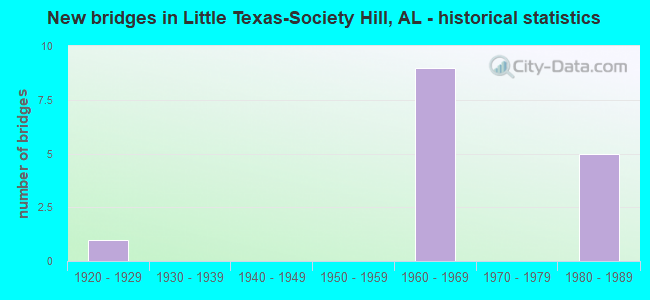
- New bridges - historical statistics
- 11920-1929
- 91960-1969
- 51980-1989


- Bridge Condition - Deck
- 10.0%Good
- 40.0%Satisfactory
- 40.0%Fair
- 10.0%Serious

- Bridge Condition - Superstructure
- 20.0%Good
- 30.0%Satisfactory
- 40.0%Fair
- 10.0%Serious

- Bridge Condition - Substructure
- 10.0%Good
- 30.0%Satisfactory
- 30.0%Fair
- 20.0%Poor
- 10.0%Serious

- Bridge Condition - Channel
- 26.7%Good
- 46.7%Satisfactory
- 20.0%Fair
- 6.7%Poor

- Bridge Condition - Culverts
- 60.0%Good
- 40.0%Satisfactory
Find on map >> Show street view
Structure Number: 149, Location: 2ND AVE. * 6TH ST. (Lat: 33.506014, Lng: -86.826631), Route carried "on" structure: City street , Year Built: 1920, Status: Posted for load, Structure Length: 0.99m (3.25ft), Average Daily Traffic: 2,500 (year 2018), Truck Traffic: 3%, Average Future Daily Traffic: 3,000 (year 2038), Features Intersected: BRANCH, Facility Carried by Structure: 2ND AVE. NORTH
Minimum Vertical Clearance: 30+ m (98+ ft), Kilometerpoint: 4.699, Lanes on structure: 4, Owner: City or Municipal Highway Agency, Approaching Roadway Width: 12.2m (40.0ft), Material/Design: Concrete, Design/Construction: Slab, Number Of Spans In Main Unit: 2, Length of Maximum Span: 5.1m (16.7ft), Curb or Sidewalk Widths: Left: 3.0m (9.8ft), Right: 3.0m (9.8ft), Curb-To-Curb Width: 12.4m (40.7ft), Out-to-Out Width: 18.3m (60.0ft)
Condition: Deck: Fair, Superstructure: Fair, Substructure: Fair, Channel: Fair, Operating Rating: 27.2 metric tons, Method Used To Determine Operating Rating: Field evaluation and documented engineering judgment, Inventory Rating: 20.4 metric tons, Method Used To Determine Inventory Rating: Field evaluation and documented engineering judgment, Structural Evaluation: Somewhat better than minimum adequacy, Deck Geometry: High priority of replacement, Waterway Adequacy: Somewhat better than minimum adequacy, Approach Roadway Alignment: Equal to present minimum criteria, Bridge Posting: Required (Relationship of Operating Rating to Maximum Legal Load: 20.0 - 29.9% below), Length Of Structure Improvement: 1.66m (5.45ft), Designated Inspection Frequency: Every 24 months, Other Special Inspection Frequency: Every 12 months, Inspection Date: June 2020, Other Special Inspection Date: June 2021, Bridge Improvement Cost: $671,000, Roadway Improvement Cost: $67,000, Total Project Cost: $738,000 ( Estimate for 2022), Deck Structure Type: Concrete Cast-file-Place, Wearing Surface/Protective System: Wearing Surface: Bituminous
Find on map >> Show street view
Structure Number: 7371, Location: 3.5 MILES WEST OF SR80 (Lat: 32.422928, Lng: -85.535119), Route carried "on" structure: County highway 22, Year Built: 1961, Status: Open, Structure Length: 3.47m (11.38ft), Average Daily Traffic: 325 (year 2015), Truck Traffic: 20%, Average Future Daily Traffic: 350 (year 2035), Design Load: H 15, Features Intersected: CHEWACLA CREEK REL
Minimum Vertical Clearance: 30+ m (98+ ft), Kilometerpoint: 0.010, Lanes on structure: 2, Owner: County Highway Agency, Approaching Roadway Width: 6.7m (22.0ft), Material/Design: Concrete, Design/Construction: Channel Beam, Number Of Spans In Main Unit: 6, Length of Maximum Span: 5.8m (19.0ft), Curb-To-Curb Width: 6.7m (22.0ft), Out-to-Out Width: 7.1m (23.3ft)
Condition: Deck: Fair, Superstructure: Satisfactory, Substructure: Fair, Channel: Good, Operating Rating: 45.4 metric tons, Method Used To Determine Operating Rating: Load Factor (LF), Inventory Rating: 27.2 metric tons, Method Used To Determine Inventory Rating: Load Factor (LF), Structural Evaluation: Somewhat better than minimum adequacy, Waterway Adequacy: Equal to present minimum criteria, Approach Roadway Alignment: Equal to present minimum criteria, Length Of Structure Improvement: 4.37m (14.34ft), Designated Inspection Frequency: Every 24 months, Inspection Date: Febuary 2021, Bridge Improvement Cost: $689,000, Roadway Improvement Cost: $69,000, Total Project Cost: $758,000 ( Estimate for 2022), Deck Structure Type: Concrete Precast Panels
Find on map >> Show street view
Structure Number: 7372, Location: 2.2 MI. W. OF SR8 (Lat: 32.422961, Lng: -85.530297), Route carried "on" structure: County highway 22, Year Built: 1961, Status: Posted for load, Structure Length: 13.33m (43.73ft), Average Daily Traffic: 325 (year 2016), Truck Traffic: 20%, Average Future Daily Traffic: 350 (year 2036), Design Load: H 15, Features Intersected: CHEWACLA CREEK
Minimum Vertical Clearance: 30+ m (98+ ft), Kilometerpoint: 0.010, Lanes on structure: 2, Owner: County Highway Agency, Approaching Roadway Width: 8.5m (27.9ft), Material/Design: Concrete, Design/Construction: Tee Beam, Number Of Spans In Main Unit: 1, Number Of Approach Spans: 21, Length of Maximum Span: 12.2m (40.0ft), Curb-To-Curb Width: 6.7m (22.0ft), Out-to-Out Width: 7.1m (23.3ft)
Condition: Deck: Satisfactory, Superstructure: Satisfactory, Substructure: Poor, Channel: Poor, Operating Rating: 9.1 metric tons, Method Used To Determine Operating Rating: Load Factor (LF), Inventory Rating: 6.4 metric tons, Method Used To Determine Inventory Rating: Load Factor (LF), Structural Evaluation: High priority of replacement, Deck Geometry: Meets minimum limits, Waterway Adequacy: Better than present minimum criteria, Approach Roadway Alignment: Equal to present minimum criteria, Bridge Posting: Required (Relationship of Operating Rating to Maximum Legal Load: > 39.9% below), Length Of Structure Improvement: 14.15m (46.42ft), Designated Inspection Frequency: Every 24 months, Other Special Inspection Frequency: Every 12 months, Inspection Date: September 2021, Other Special Inspection Date: September 2021, Bridge Improvement Cost: $2,231,000, Roadway Improvement Cost: $223,000, Total Project Cost: $2,454,000 ( Estimate for 2022), Deck Structure Type: Concrete Precast Panels
Find on map >> Show street view
Structure Number: 7373, Location: 2.25 MI WEST HWY80W (Lat: 32.423033, Lng: -85.513231), Route carried "on" structure: County highway 22, Year Built: 1961, Status: Posted for load, Structure Length: 2.31m (7.58ft), Average Daily Traffic: 325 (year 2016), Truck Traffic: 20%, Average Future Daily Traffic: 350 (year 2036), Design Load: H 15, Features Intersected: UNNAMED BRANCH
Minimum Vertical Clearance: 30+ m (98+ ft), Kilometerpoint: 0.010, Lanes on structure: 2, Owner: County Highway Agency, Approaching Roadway Width: 6.7m (22.0ft), Material/Design: Concrete, Design/Construction: Channel Beam, Number Of Spans In Main Unit: 4, Length of Maximum Span: 5.8m (19.0ft), Curb-To-Curb Width: 6.6m (21.7ft), Out-to-Out Width: 6.6m (21.7ft)
Condition: Deck: Fair, Superstructure: Fair, Substructure: Poor, Channel: Satisfactory, Operating Rating: 11.8 metric tons, Method Used To Determine Operating Rating: Load Factor (LF), Inventory Rating: 10.0 metric tons, Method Used To Determine Inventory Rating: Load Factor (LF), Structural Evaluation: High priority of corrective action, Deck Geometry: Meets minimum limits, Waterway Adequacy: Equal to present minimum criteria, Approach Roadway Alignment: Equal to present minimum criteria, Bridge Posting: Required (Relationship of Operating Rating to Maximum Legal Load: > 39.9% below), Length Of Structure Improvement: 3.15m (10.33ft), Designated Inspection Frequency: Every 24 months, Other Special Inspection Frequency: Every 12 months, Inspection Date: Febuary 2021, Other Special Inspection Date: Febuary 2022, Bridge Improvement Cost: $453,000, Roadway Improvement Cost: $45,000, Total Project Cost: $498,000 ( Estimate for 2022), Deck Structure Type: Concrete Cast-file-Place
Find on map >> Show street view
Structure Number: 8042, Location: NE1/4 S26 T16 R25 (Lat: 32.347028, Lng: -85.504194), Route carried "on" structure: County highway 79, Year Built: 1963, Status: Posted for load, Structure Length: 8.29m (27.20ft), Average Daily Traffic: 108 (year 2016), Truck Traffic: 15%, Average Future Daily Traffic: 125 (year 2036), Design Load: H 15, Features Intersected: OPINTLOCCO CREEK
Minimum Vertical Clearance: 30+ m (98+ ft), Kilometerpoint: 0.010, Lanes on structure: 2, Owner: County Highway Agency, Approaching Roadway Width: 5.8m (19.0ft), Material/Design: Concrete continuous, Design/Construction: Tee Beam, Number Of Spans In Main Unit: 8, Length of Maximum Span: 10.4m (34.1ft), Curb-To-Curb Width: 6.6m (21.7ft), Out-to-Out Width: 7.2m (23.6ft)
Condition: Deck: Satisfactory, Superstructure: Good, Substructure: Satisfactory, Channel: Satisfactory, Operating Rating: 37.9 metric tons, Method Used To Determine Operating Rating: Load Factor (LF), Inventory Rating: 22.8 metric tons, Method Used To Determine Inventory Rating: Load Factor (LF), Structural Evaluation: Equal to present minimum criteria, Deck Geometry: Meets minimum limits, Waterway Adequacy: Equal to present desirable criteria, Approach Roadway Alignment: Somewhat better than minimum adequacy, Bridge Posting: Required (Relationship of Operating Rating to Maximum Legal Load: 0.1 - 9.9% below), Length Of Structure Improvement: 9.29m (30.48ft), Designated Inspection Frequency: Every 24 months, Other Special Inspection Frequency: Every 12 months, Inspection Date: Febuary 2021, Other Special Inspection Date: Febuary 2022, Bridge Improvement Cost: $1,465,000, Roadway Improvement Cost: $147,000, Total Project Cost: $1,612,000 ( Estimate for 2022), Deck Structure Type: Concrete Cast-file-Place
Find on map >> Show street view
Structure Number: 8043, Location: 4 MI WEST US80/SR8 (Lat: 32.383097, Lng: -85.485692), Route carried "on" structure: County highway 79, Year Built: 1963, Status: Open, Structure Length: 1.74m (5.71ft), Average Daily Traffic: 108 (year 2016), Truck Traffic: 15%, Average Future Daily Traffic: 125 (year 2036), Design Load: H 15, Features Intersected: KELLY CREEK
Minimum Vertical Clearance: 30+ m (98+ ft), Kilometerpoint: 0.010, Lanes on structure: 2, Owner: County Highway Agency, Approaching Roadway Width: 6.1m (20.0ft), Material/Design: Concrete, Design/Construction: Channel Beam, Number Of Spans In Main Unit: 3, Length of Maximum Span: 5.8m (19.0ft), Curb-To-Curb Width: 6.1m (20.0ft), Out-to-Out Width: 7.1m (23.3ft)
Condition: Deck: Satisfactory, Superstructure: Satisfactory, Substructure: Satisfactory, Channel: Satisfactory, Operating Rating: 56.6 metric tons, Method Used To Determine Operating Rating: Load Factor (LF), Inventory Rating: 36.7 metric tons, Method Used To Determine Inventory Rating: Load Factor (LF), Structural Evaluation: Equal to present minimum criteria, Waterway Adequacy: Better than present minimum criteria, Approach Roadway Alignment: Equal to present minimum criteria, Length Of Structure Improvement: 2.44m (8.01ft), Designated Inspection Frequency: Every 24 months, Inspection Date: Febuary 2022, Bridge Improvement Cost: $385,000, Roadway Improvement Cost: $39,000, Total Project Cost: $424,000 ( Estimate for 2022), Deck Structure Type: Concrete Precast Panels
Find on map >> Show street view
Structure Number: 8056, Location: 2.8 MI W US80/SR8 (Lat: 32.411517, Lng: -85.483206), Route carried "on" structure: County highway 91, Year Built: 1963, Status: Open, Structure Length: 5.21m (17.09ft), Average Daily Traffic: 108 (year 2016), Truck Traffic: 2%, Average Future Daily Traffic: 120 (year 2036), Design Load: H 15, Features Intersected: LONG BRANCH
Minimum Vertical Clearance: 30+ m (98+ ft), Kilometerpoint: 0.010, Lanes on structure: 2, Owner: County Highway Agency, Approaching Roadway Width: 5.5m (18.0ft), Material/Design: Concrete, Design/Construction: Channel Beam, Number Of Spans In Main Unit: 9, Length of Maximum Span: 5.8m (19.0ft), Curb-To-Curb Width: 6.7m (22.0ft), Out-to-Out Width: 7.2m (23.6ft)
Condition: Deck: Fair, Superstructure: Fair, Substructure: Fair, Channel: Satisfactory, Operating Rating: 47.9 metric tons, Method Used To Determine Operating Rating: Load Factor (LF), Inventory Rating: 28.8 metric tons, Method Used To Determine Inventory Rating: Load Factor (LF), Structural Evaluation: Somewhat better than minimum adequacy, Waterway Adequacy: Somewhat better than minimum adequacy, Approach Roadway Alignment: Equal to present minimum criteria, Length Of Structure Improvement: 6.23m (20.44ft), Designated Inspection Frequency: Every 24 months, Inspection Date: January 2021, Bridge Improvement Cost: $983,000, Roadway Improvement Cost: $98,000, Total Project Cost: $1,081,000 ( Estimate for 2022), Deck Structure Type: Concrete Precast Panels
Find on map >> Show street view
Structure Number: 8638, Location: .5 MI NO OF AL-8/US80 (Lat: 32.435883, Lng: -85.464175), Route carried "on" structure: County highway , Year Built: 1965, Status: Closed, Structure Length: 1.57m (5.15ft), Average Daily Traffic: 52 (year 2016), Average Future Daily Traffic: 100 (year 2036), Design Load: H 10, Features Intersected: LONG BRANCH, Facility Carried by Structure: OLD COLUMBUS RD
Minimum Vertical Clearance: 30+ m (98+ ft), Kilometerpoint: 0.010, Lanes on structure: 1, Owner: County Highway Agency, Approaching Roadway Width: 3.7m (12.1ft), Material/Design: Wood or Timber, Design/Construction: Stringer/Multi-beam, Number Of Spans In Main Unit: 3, Length of Maximum Span: 5.2m (17.1ft), Curb-To-Curb Width: 7.0m (23.0ft), Out-to-Out Width: 7.3m (24.0ft)
Condition: Deck: Serious, Superstructure: Serious, Substructure: Serious, Channel: Fair, Deck Geometry: Somewhat better than minimum adequacy, Waterway Adequacy: Better than present minimum criteria, Approach Roadway Alignment: Somewhat better than minimum adequacy, Bridge Posting: Required (Relationship of Operating Rating to Maximum Legal Load: > 39.9% below), Length Of Structure Improvement: 2.26m (7.41ft), Designated Inspection Frequency: Every 24 months, Other Special Inspection Frequency: Every 3 months, Inspection Date: January 2019, Other Special Inspection Date: January 2019, Bridge Improvement Cost: $371,000, Roadway Improvement Cost: $37,000, Total Project Cost: $408,000 ( Estimate for 2022), Deck Structure Type: Wood or Timber, Wearing Surface/Protective System: Wearing Surface: Wood or Timber
Find on map >> Show street view
Structure Number: 8693, Location: SW1/4 S12 T15 R25 (Lat: 32.294397, Lng: -85.501839), Route carried "on" structure: County highway 10, Year Built: 1965, Status: Open, Structure Length: 0.75m (2.46ft), Average Daily Traffic: 310 (year 2016), Truck Traffic: 45%, Average Future Daily Traffic: 400 (year 2036), Design Load: H 15, Features Intersected: TANYARD CREEK
Minimum Vertical Clearance: 30+ m (98+ ft), Kilometerpoint: 0.010, Lanes on structure: 2, Owner: County Highway Agency, Approaching Roadway Width: 6.7m (22.0ft), Material/Design: Concrete, Design/Construction: Culvert, Number Of Spans In Main Unit: 2, Length of Maximum Span: 3.7m (12.1ft)
Condition: Channel: Good, Culverts: Good, Operating Rating: 60.7 metric tons, Method Used To Determine Operating Rating: Load Factor (LF), Inventory Rating: 36.5 metric tons, Method Used To Determine Inventory Rating: Load Factor (LF), Structural Evaluation: Better than present minimum criteria, Waterway Adequacy: Equal to present desirable criteria, Approach Roadway Alignment: Equal to present minimum criteria, Length Of Structure Improvement: 1.40m (4.59ft), Designated Inspection Frequency: Every 24 months, Inspection Date: March 2020, Bridge Improvement Cost: $259,000, Roadway Improvement Cost: $26,000, Total Project Cost: $285,000 ( Estimate for 2022)
Find on map >> Show street view
Structure Number: 9679, Location: .42 MILES NORTH CO RD 26 (Lat: 32.403772, Lng: -85.524678), Route carried "on" structure: County highway 24, Year Built: 1968, Status: Open, Structure Length: 4.63m (15.19ft), Average Daily Traffic: 268 (year 2015), Truck Traffic: 10%, Average Future Daily Traffic: 300 (year 2035), Design Load: H 15, Features Intersected: LONG BRANCH
Minimum Vertical Clearance: 30+ m (98+ ft), Kilometerpoint: 0.010, Lanes on structure: 2, Owner: County Highway Agency, Approaching Roadway Width: 5.8m (19.0ft), Material/Design: Concrete, Design/Construction: Channel Beam, Number Of Spans In Main Unit: 8, Length of Maximum Span: 5.8m (19.0ft), Curb-To-Curb Width: 7.4m (24.3ft), Out-to-Out Width: 7.4m (24.3ft)
Condition: Deck: Satisfactory, Superstructure: Fair, Substructure: Satisfactory, Channel: Good, Operating Rating: 45.4 metric tons, Method Used To Determine Operating Rating: Load Factor (LF), Inventory Rating: 27.2 metric tons, Method Used To Determine Inventory Rating: Load Factor (LF), Structural Evaluation: Somewhat better than minimum adequacy, Deck Geometry: Somewhat better than minimum adequacy, Waterway Adequacy: Better than present minimum criteria, Approach Roadway Alignment: Equal to present minimum criteria, Length Of Structure Improvement: 5.63m (18.47ft), Designated Inspection Frequency: Every 24 months, Inspection Date: January 2021, Bridge Improvement Cost: $927,000, Roadway Improvement Cost: $93,000, Total Project Cost: $1,020,000 ( Estimate for 2022), Deck Structure Type: Concrete Precast Panels
Find on map >> Show street view
Structure Number: 13966, Location: 0.8 MI. EAST CO RD 53 (Lat: 32.522017, Lng: -85.595833), Route carried "on" structure: County highway 54, Year Built: 1986, Status: Open, Structure Length: 1.57m (5.15ft), Average Daily Traffic: 150 (year 2016), Truck Traffic: 7%, Average Future Daily Traffic: 400 (year 2036), Design Load: HS 20, Features Intersected: HODNETT CREEK
Minimum Vertical Clearance: 30+ m (98+ ft), Kilometerpoint: 0.010, Lanes on structure: 2, Owner: County Highway Agency, Approaching Roadway Width: 8.5m (27.9ft), Material/Design: Concrete, Design/Construction: Culvert, Number Of Spans In Main Unit: 4, Length of Maximum Span: 3.7m (12.1ft)
Condition: Channel: Satisfactory, Culverts: Good, Operating Rating: 88.9 metric tons, Method Used To Determine Operating Rating: Load Factor (LF), Inventory Rating: 57.6 metric tons, Method Used To Determine Inventory Rating: Load Factor (LF), Structural Evaluation: Better than present minimum criteria, Waterway Adequacy: Equal to present desirable criteria, Approach Roadway Alignment: Equal to present minimum criteria, Length Of Structure Improvement: 2.25m (7.38ft), Designated Inspection Frequency: Every 24 months, Inspection Date: March 2020, Bridge Improvement Cost: $546,000, Roadway Improvement Cost: $55,000, Total Project Cost: $601,000 ( Estimate for 2022)
Find on map >> Show street view
Structure Number: 14247, Location: 0.75 MI. SO I-85 (Lat: 32.507214, Lng: -85.578514), Route carried "on" structure: County highway 54, Year Built: 1986, Status: Open, Structure Length: 3.11m (10.20ft), Average Daily Traffic: 57 (year 2016), Average Future Daily Traffic: 70 (year 2036), Design Load: HS 20, Features Intersected: CHOCTAFAULA CREEK
Minimum Vertical Clearance: 30+ m (98+ ft), Kilometerpoint: 0.010, Lanes on structure: 2, Owner: County Highway Agency, Approaching Roadway Width: 6.1m (20.0ft), Material/Design: Concrete, Design/Construction: Channel Beam, Number Of Spans In Main Unit: 3, Length of Maximum Span: 10.4m (34.1ft), Curb-To-Curb Width: 7.3m (24.0ft), Out-to-Out Width: 7.4m (24.3ft)
Condition: Deck: Good, Superstructure: Good, Substructure: Good, Channel: Good, Operating Rating: 87.6 metric tons, Method Used To Determine Operating Rating: Load Factor (LF), Inventory Rating: 52.5 metric tons, Method Used To Determine Inventory Rating: Load Factor (LF), Structural Evaluation: Better than present minimum criteria, Waterway Adequacy: Better than present minimum criteria, Approach Roadway Alignment: Equal to present minimum criteria, Length Of Structure Improvement: 3.96m (12.99ft), Designated Inspection Frequency: Every 24 months, Inspection Date: March 2020, Bridge Improvement Cost: $652,000, Roadway Improvement Cost: $65,000, Total Project Cost: $717,000 ( Estimate for 2022), Deck Structure Type: Concrete Precast Panels
Find on map >> Show street view
Structure Number: 14814, Location: 1.31 MILES NORTH SR8/US80 (Lat: 32.470358, Lng: -85.542183), Route carried "on" structure: County highway , Year Built: 1989, Status: Open, Structure Length: 1.16m (3.81ft), Average Daily Traffic: 52 (year 2015), Average Future Daily Traffic: 75 (year 2035), Design Load: HS 20, Features Intersected: BIG BRANCH, Facility Carried by Structure: BUFFORD RD
Minimum Vertical Clearance: 30+ m (98+ ft), Kilometerpoint: 0.010, Lanes on structure: 2, Owner: County Highway Agency, Approaching Roadway Width: 4.3m (14.1ft), Material/Design: Concrete, Design/Construction: Culvert, Number Of Spans In Main Unit: 3, Length of Maximum Span: 3.7m (12.1ft), Curb-To-Curb Width: 12.3m (40.4ft), Out-to-Out Width: 12.8m (42.0ft)
Condition: Channel: Satisfactory, Culverts: Satisfactory, Operating Rating: 66.5 metric tons, Method Used To Determine Operating Rating: Load Factor (LF), Inventory Rating: 39.9 metric tons, Method Used To Determine Inventory Rating: Load Factor (LF), Structural Evaluation: Equal to present minimum criteria, Deck Geometry: Superior to present desirable criteria, Waterway Adequacy: Better than present minimum criteria, Approach Roadway Alignment: Better than present minimum criteria, Length Of Structure Improvement: 1.83m (6.00ft), Designated Inspection Frequency: Every 24 months, Inspection Date: January 2021, Bridge Improvement Cost: $444,000, Roadway Improvement Cost: $44,000, Total Project Cost: $488,000 ( Estimate for 2022)
Find on map >> Show street view
Structure Number: 14815, Location: 1.9 MI. SOUTH SR8/US80E (Lat: 32.445067, Lng: -85.579764), Route carried "on" structure: County highway , Year Built: 1989, Status: Open, Structure Length: 1.17m (3.84ft), Average Daily Traffic: 62 (year 2015), Average Future Daily Traffic: 70 (year 2035), Design Load: HS 20, Features Intersected: CAMP GROUND BRANCH, Facility Carried by Structure: CO RD 71
Minimum Vertical Clearance: 30+ m (98+ ft), Kilometerpoint: 0.010, Lanes on structure: 2, Owner: County Highway Agency, Approaching Roadway Width: 5.8m (19.0ft), Material/Design: Concrete, Design/Construction: Culvert, Number Of Spans In Main Unit: 3, Length of Maximum Span: 3.7m (12.1ft), Curb or Sidewalk Widths: Left: 0.2m (0.7ft), Right: 0.2m (0.7ft), Curb-To-Curb Width: 6.0m (19.7ft), Out-to-Out Width: 12.8m (42.0ft)
Condition: Channel: Satisfactory, Culverts: Good, Operating Rating: 58.2 metric tons, Method Used To Determine Operating Rating: Load Factor (LF), Inventory Rating: 34.9 metric tons, Method Used To Determine Inventory Rating: Load Factor (LF), Structural Evaluation: Better than present minimum criteria, Deck Geometry: Meets minimum limits, Waterway Adequacy: Better than present minimum criteria, Approach Roadway Alignment: Equal to present minimum criteria, Length Of Structure Improvement: 1.85m (6.07ft), Designated Inspection Frequency: Every 24 months, Inspection Date: January 2021, Bridge Improvement Cost: $449,000, Roadway Improvement Cost: $45,000, Total Project Cost: $494,000 ( Estimate for 2022), Wearing Surface/Protective System: Wearing Surface: Bituminous
Find on map >> Show street view
Structure Number: 149, Location: 0.9 MI NORTH SR8/US80 (Lat: 32.439050, Lng: -85.450397), Route carried "on" structure: County highway 43, Year Built: 1989, Status: Open, Structure Length: 1.55m (5.09ft), Average Daily Traffic: 289 (year 1990), Truck Traffic: 15%, Average Future Daily Traffic: 400 (year 2034), Design Load: H 20, Features Intersected: LONG BRANCH, Facility Carried by Structure: CO RD 4
Minimum Vertical Clearance: 30+ m (98+ ft), Kilometerpoint: 0.010, Lanes on structure: 2, Owner: County Highway Agency, Approaching Roadway Width: 8.5m (27.9ft), Material/Design: Concrete, Design/Construction: Culvert, Number Of Spans In Main Unit: 4, Length of Maximum Span: 3.7m (12.1ft), Curb-To-Curb Width: 8.8m (28.9ft), Out-to-Out Width: 8.8m (28.9ft)
Condition: Channel: Fair, Culverts: Satisfactory, Operating Rating: 69.6 metric tons, Method Used To Determine Operating Rating: Load Factor (LF), Inventory Rating: 41.7 metric tons, Method Used To Determine Inventory Rating: Load Factor (LF), Structural Evaluation: Equal to present minimum criteria, Waterway Adequacy: Better than present minimum criteria, Approach Roadway Alignment: Equal to present minimum criteria, Length Of Structure Improvement: 2.23m (7.32ft), Designated Inspection Frequency: Every 24 months, Inspection Date: December 2020, Bridge Improvement Cost: $426,000, Roadway Improvement Cost: $43,000, Total Project Cost: $469,000 ( Estimate for 2022), Wearing Surface/Protective System: Wearing Surface: Bituminous