Bridge Statistics for Livingston, Tennessee (TN)
Condition, Traffic, Stress, Structural Evaluation, Project Costs
- National Bridge Inventory (NBI) Statistics
- 30Number of bridges
- 246ft / 74.9mTotal length
- $4,237,000Total costs
- 149,273Total average daily traffic
- 13,979Total average daily truck traffic
- National Bridge Inventory (NBI) Registered Bridges for Livingston
- No street view available for this location
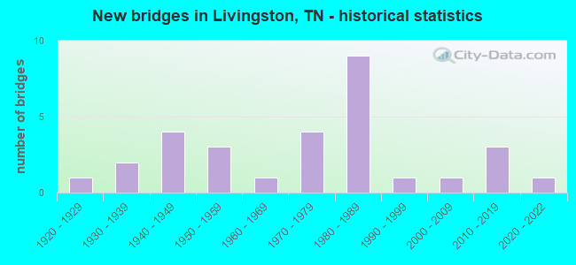
- New bridges - historical statistics
- 11920-1929
- 21930-1939
- 41940-1949
- 31950-1959
- 11960-1969
- 41970-1979
- 91980-1989
- 11990-1999
- 12000-2009
- 32010-2019
- 12020-2022

- Reconstructed bridges - Historical Statistics
- 11980-1989
- 01990-1999
- 02000-2009
- 22010-2019


- Bridge Condition - Deck
- 66.7%Good
- 22.2%Satisfactory
- 11.1%Fair

- Bridge Condition - Superstructure
- 11.1%Very good
- 44.4%Good
- 22.2%Satisfactory
- 11.1%Fair
- 11.1%Poor

- Bridge Condition - Substructure
- 66.7%Good
- 22.2%Satisfactory
- 11.1%Poor

- Bridge Condition - Channel
- 20.7%Good
- 58.6%Satisfactory
- 17.2%Fair
- 3.4%Poor

- Bridge Condition - Culverts
- 65.0%Good
- 30.0%Satisfactory
- 5.0%Fair
Find on map >> Show street view
Structure Number: 670A1380001, Location: .5 MI NORTH OF SR 42 (Lat: 36.451200, Lng: -85.278867), Route carried "on" structure: County highway 138, Year Built: 1984, Status: Open, Structure Length: 1.04m (3.41ft), Average Daily Traffic: 110 (year 2022), Truck Traffic: 2%, Average Future Daily Traffic: 176 (year 2041), Design Load: HS 20, Features Intersected: LITTLE EAGLE CREEK
Minimum Vertical Clearance: 30+ m (98+ ft), Kilometerpoint: 1.197, Lanes on structure: 2, Owner: County Highway Agency, Approaching Roadway Width: 7.3m (24.0ft), Skew: 1 degrees, Material/Design: Concrete continuous, Design/Construction: Culvert, Number Of Spans In Main Unit: 2, Length of Maximum Span: 4.6m (15.1ft), Curb-To-Curb Width: 6.8m (22.3ft), Out-to-Out Width: 7.9m (25.9ft)
Condition: Channel: Satisfactory, Culverts: Good, Operating Rating: 72.9 metric tons, Method Used To Determine Operating Rating: Load Factor (LF), Inventory Rating: 32.4 metric tons, Method Used To Determine Inventory Rating: Load Factor (LF), Structural Evaluation: Better than present minimum criteria, Deck Geometry: Meets minimum limits, Waterway Adequacy: Better than present minimum criteria, Approach Roadway Alignment: Equal to present minimum criteria, Designated Inspection Frequency: Every 24 months, Inspection Date: December 2020
Find on map >> Show street view
Structure Number: 670A1380003, Location: .4 MI NORTH OF SR 42 (Lat: 36.449317, Lng: -85.274017), Route carried "on" structure: County highway 138, Year Built: 2000, Status: Open, Structure Length: 0.99m (3.25ft), Average Daily Traffic: 130 (year 2022), Truck Traffic: 2%, Average Future Daily Traffic: 208 (year 2041), Features Intersected: BIG EAGLE CREEK
Minimum Vertical Clearance: 30+ m (98+ ft), Kilometerpoint: 1.691, Lanes on structure: 2, Owner: County Highway Agency, Approaching Roadway Width: 4.6m (15.1ft), Material/Design: Concrete continuous, Design/Construction: Culvert, Number Of Spans In Main Unit: 2, Length of Maximum Span: 4.6m (15.1ft), Curb-To-Curb Width: 6.7m (22.0ft), Out-to-Out Width: 8.4m (27.6ft)
Condition: Channel: Satisfactory, Culverts: Good, Operating Rating: 44.1 metric tons, Method Used To Determine Operating Rating: Field evaluation and documented engineering judgment, Inventory Rating: 32.4 metric tons, Method Used To Determine Inventory Rating: Field evaluation and documented engineering judgment, Structural Evaluation: Better than present minimum criteria, Deck Geometry: Meets minimum limits, Waterway Adequacy: Better than present minimum criteria, Approach Roadway Alignment: Equal to present minimum criteria, Designated Inspection Frequency: Every 24 months, Inspection Date: December 2020, Deck Structure Type: Concrete Cast-file-Place, Wearing Surface/Protective System: Wearing Surface: Monolithic Concrete, Deck Protection: Epoxy Coated Reinforcing
Find on map >> Show street view
Structure Number: 670A3700001, Location: .3 MI WEST OF SR 84 (Lat: 36.332075, Lng: -85.312444), Route carried "on" structure: County highway 370, Year Built: 1974, Status: Open, Structure Length: 1.25m (4.10ft), Average Daily Traffic: 200 (year 2022), Truck Traffic: 2%, Average Future Daily Traffic: 320 (year 2041), Features Intersected: CARR CREEK
Minimum Vertical Clearance: 30+ m (98+ ft), Kilometerpoint: 0.391, Lanes on structure: 2, Owner: County Highway Agency, Approaching Roadway Width: 9.8m (32.2ft), Skew: 1 degrees, Material/Design: Concrete continuous, Design/Construction: Culvert, Number Of Spans In Main Unit: 3, Length of Maximum Span: 3.7m (12.1ft)
Condition: Channel: Fair, Culverts: Satisfactory, Operating Rating: 40.5 metric tons, Method Used To Determine Operating Rating: Load Factor (LF), Inventory Rating: 24.3 metric tons, Method Used To Determine Inventory Rating: Load Factor (LF), Structural Evaluation: Equal to present minimum criteria, Waterway Adequacy: Better than present minimum criteria, Approach Roadway Alignment: Equal to present desirable criteria, Designated Inspection Frequency: Every 24 months, Inspection Date: December 2020
Find on map >> Show street view
Structure Number: 670A3820001, Location: 3 MI WEST OF SR 42 (Lat: 36.340856, Lng: -85.366333), Route carried "on" structure: County highway 382, Year Built: 1984, Status: Open, Structure Length: 2.01m (6.59ft), Average Daily Traffic: 220 (year 2022), Truck Traffic: 2%, Average Future Daily Traffic: 352 (year 2040), Design Load: HS 20, Features Intersected: CARR CREEK
Minimum Vertical Clearance: 30+ m (98+ ft), Kilometerpoint: 0.682, Lanes on structure: 2, Owner: County Highway Agency, Approaching Roadway Width: 7.0m (23.0ft), Material/Design: Concrete continuous, Design/Construction: Culvert, Number Of Spans In Main Unit: 4, Length of Maximum Span: 4.6m (15.1ft), Curb-To-Curb Width: 7.4m (24.3ft), Out-to-Out Width: 8.6m (28.2ft)
Condition: Channel: Fair, Culverts: Good, Operating Rating: 81.0 metric tons, Method Used To Determine Operating Rating: Load Factor (LF), Inventory Rating: 32.4 metric tons, Method Used To Determine Inventory Rating: Load Factor (LF), Structural Evaluation: Better than present minimum criteria, Deck Geometry: Somewhat better than minimum adequacy, Waterway Adequacy: Better than present minimum criteria, Approach Roadway Alignment: Equal to present minimum criteria, Designated Inspection Frequency: Every 24 months, Inspection Date: December 2020, Deck Structure Type: Concrete Cast-file-Place, Wearing Surface/Protective System: Wearing Surface: Bituminous
Find on map >> Show street view
Structure Number: 670A4040001, Location: 1 MI WEST OF SR 42 (Lat: 36.331600, Lng: -85.350617), Route carried "on" structure: County highway 404, Year Built: 1984, Status: Open, Structure Length: 0.98m (3.22ft), Average Daily Traffic: 110 (year 2022), Truck Traffic: 2%, Average Future Daily Traffic: 176 (year 2041), Design Load: HS 20, Features Intersected: ROARING RIVER
Minimum Vertical Clearance: 30+ m (98+ ft), Kilometerpoint: 4.307, Lanes on structure: 2, Owner: County Highway Agency, Approaching Roadway Width: 5.5m (18.0ft), Material/Design: Concrete continuous, Design/Construction: Culvert, Number Of Spans In Main Unit: 2, Length of Maximum Span: 4.6m (15.1ft), Curb-To-Curb Width: 6.7m (22.0ft), Out-to-Out Width: 8.1m (26.6ft)
Condition: Channel: Satisfactory, Culverts: Good, Operating Rating: 89.1 metric tons, Method Used To Determine Operating Rating: Load Factor (LF), Inventory Rating: 32.4 metric tons, Method Used To Determine Inventory Rating: Load Factor (LF), Structural Evaluation: Better than present minimum criteria, Deck Geometry: Meets minimum limits, Waterway Adequacy: Better than present minimum criteria, Approach Roadway Alignment: Equal to present minimum criteria, Designated Inspection Frequency: Every 24 months, Inspection Date: December 2020, Deck Structure Type: Concrete Cast-file-Place, Wearing Surface/Protective System: Wearing Surface: Bituminous
Find on map >> Show street view
Structure Number: 67F00010001, Location: 3 MI NORTH OF SR85 (Lat: 36.411683, Lng: -85.374933), Route carried "on" structure: County highway 1178, Year Built: 1940, Status: Open, Structure Length: 1.34m (4.40ft), Average Daily Traffic: 542 (year 2020), Truck Traffic: 4%, Average Future Daily Traffic: 1,472 (year 2041), Design Load: H 15, Features Intersected: FLAT CREEK
Minimum Vertical Clearance: 30+ m (98+ ft), Kilometerpoint: 5.021, Lanes on structure: 2, Owner: County Highway Agency, Approaching Roadway Width: 9.1m (29.9ft), Material/Design: Steel, Design/Construction: Stringer/Multi-beam, Number Of Spans In Main Unit: 1, Length of Maximum Span: 12.8m (42.0ft), Curb-To-Curb Width: 6.1m (20.0ft), Out-to-Out Width: 6.4m (21.0ft)
Condition: Deck: Fair, Superstructure: Fair, Substructure: Satisfactory, Channel: Good, Operating Rating: 36.9 metric tons, Method Used To Determine Operating Rating: Allowable Stress (AS), Inventory Rating: 21.6 metric tons, Method Used To Determine Inventory Rating: Allowable Stress (AS), Structural Evaluation: Somewhat better than minimum adequacy, Deck Geometry: High priority of corrective action, Waterway Adequacy: Better than present minimum criteria, Approach Roadway Alignment: Equal to present desirable criteria, Length Of Structure Improvement: 1.34m (4.40ft), Designated Inspection Frequency: Every 24 months, Inspection Date: December 2020, Bridge Improvement Cost: $143,000, Roadway Improvement Cost: $15,000, Total Project Cost: $215,000 ( Estimate for 2021), Deck Structure Type: Concrete Cast-file-Place, Wearing Surface/Protective System: Wearing Surface: Bituminous
Find on map >> Show street view
Structure Number: 67F00190001, Location: 4 MI WEST OF SR 42 (Lat: 36.338217, Lng: -85.377717), Route carried "on" structure: County highway 1205, Year Built: 1973, Status: Posted for load, Structure Length: 3.08m (10.10ft), Average Daily Traffic: 541 (year 2020), Truck Traffic: 2%, Average Future Daily Traffic: 866 (year 2041), Design Load: HS 20+Mod, Features Intersected: R0ARING RIVER
Minimum Vertical Clearance: 30+ m (98+ ft), Kilometerpoint: 8.320, Lanes on structure: 2, Owner: County Highway Agency, Approaching Roadway Width: 7.3m (24.0ft), Material/Design: Steel, Design/Construction: Stringer/Multi-beam, Number Of Spans In Main Unit: 2, Length of Maximum Span: 15.5m (50.9ft), Curb-To-Curb Width: 7.3m (24.0ft), Out-to-Out Width: 7.3m (24.0ft)
Condition: Deck: Satisfactory, Superstructure: Poor, Substructure: Poor, Channel: Satisfactory, Operating Rating: 16.2 metric tons, Method Used To Determine Operating Rating: Load and Resistance Factor Rating (LRFR) rating reported by rating factor(RF) method using HL-93 loadings, Inventory Rating: 12.6 metric tons, Method Used To Determine Inventory Rating: Load and Resistance Factor Rating (LRFR) rating reported by rating factor(RF) method using HL-93 loadings, Structural Evaluation: Meets minimum limits, Deck Geometry: Meets minimum limits, Waterway Adequacy: Equal to present minimum criteria, Approach Roadway Alignment: Equal to present minimum criteria, Bridge Posting: Required (Relationship of Operating Rating to Maximum Legal Load: 10.0 - 19.9% below), Length Of Structure Improvement: 3.93m (12.89ft), Designated Inspection Frequency: Every 24 months, Inspection Date: March 2021, Bridge Improvement Cost: $818,000, Roadway Improvement Cost: $82,000, Total Project Cost: $1,228,000 ( Estimate for 2021), Deck Structure Type: Corrugated Steel, Wearing Surface/Protective System: Wearing Surface: Bituminous
Find on map >> Show street view
Structure Number: 67S43930001, Location: .9 MI.N.OF SR042 (Lat: 36.449467, Lng: -85.273667), Route carried "on" structure: State highway 294, Year Built: 1959, Year Reconstructed: 2019, Status: Posted for load, Structure Length: 3.47m (11.38ft), Average Daily Traffic: 1,380 (year 2020), Truck Traffic: 5%, Average Future Daily Traffic: 2,208 (year 2042), Design Load: H 15, Features Intersected: EAGLE CREEK
Minimum Vertical Clearance: 30+ m (98+ ft), Kilometerpoint: 2.237, Lanes on structure: 2, Owner: State Highway Agency, Approaching Roadway Width: 8.8m (28.9ft), Material/Design: Concrete, Design/Construction: Tee Beam, Number Of Spans In Main Unit: 4, Length of Maximum Span: 8.8m (28.9ft), Curb-To-Curb Width: 7.3m (24.0ft), Out-to-Out Width: 8.7m (28.5ft)
Condition: Deck: Good, Superstructure: Good, Substructure: Good, Channel: Good, Operating Rating: 49.2 metric tons, Method Used To Determine Operating Rating: Load and Resistance Factor Rating (LRFR) rating reported by rating factor(RF) method using HL-93 loadings, Inventory Rating: 38.2 metric tons, Method Used To Determine Inventory Rating: Load and Resistance Factor Rating (LRFR) rating reported by rating factor(RF) method using HL-93 loadings, Structural Evaluation: Better than present minimum criteria, Deck Geometry: Meets minimum limits, Waterway Adequacy: Equal to present desirable criteria, Approach Roadway Alignment: Equal to present minimum criteria, Length Of Structure Improvement: 3.47m (11.38ft), Designated Inspection Frequency: Every 24 months, Inspection Date: November 2020, Bridge Improvement Cost: $116,000, Roadway Improvement Cost: $12,000, Total Project Cost: $175,000 ( Estimate for 2022), Deck Structure Type: Concrete Cast-file-Place, Wearing Surface/Protective System: Wearing Surface: Bituminous
Find on map >> Show street view
Structure Number: 67SR0420001, Location: 1.3 MI N OF PUTNAM CO (Lat: 36.246250, Lng: -85.387200), Route carried "on" structure: County highway 1506, Year Built: 1924, Year Reconstructed: 1987, Status: Open, Structure Length: 2.56m (8.40ft), Average Daily Traffic: 1,332 (year 2020), Truck Traffic: 3%, Average Future Daily Traffic: 1,552 (year 2041), Design Load: HS 20, Features Intersected: SPRING CREEK
Minimum Vertical Clearance: 30+ m (98+ ft), Kilometerpoint: 2.076, Lanes on structure: 2, Owner: County Highway Agency, Approaching Roadway Width: 9.8m (32.2ft), Material/Design: Prestressed concrete continuous, Design/Construction: Box Beam or Girders - Single/Spread, Number Of Spans In Main Unit: 2, Length of Maximum Span: 15.5m (50.9ft), Curb-To-Curb Width: 10.4m (34.1ft), Out-to-Out Width: 11.1m (36.4ft)
Condition: Deck: Good, Superstructure: Good, Substructure: Good, Channel: Good, Operating Rating: 44.1 metric tons, Method Used To Determine Operating Rating: Assigned rating based on Load Factor Design (LFD) reported in metric tons, Inventory Rating: 32.4 metric tons, Method Used To Determine Inventory Rating: Assigned rating based on Load Factor Design (LFD) reported in metric tons, Structural Evaluation: Better than present minimum criteria, Deck Geometry: Equal to present minimum criteria, Waterway Adequacy: Better than present minimum criteria, Approach Roadway Alignment: Equal to present desirable criteria, Designated Inspection Frequency: Every 24 months, Inspection Date: December 2020, Deck Structure Type: Concrete Precast Panels, Wearing Surface/Protective System: Wearing Surface: Bituminous, Deck Protection: Epoxy Coated Reinforcing
Find on map >> Show street view
Structure Number: 67SR0420003, Location: 4MI.SOUTH OF LIVINGSTON (Lat: 36.318936, Lng: -85.342158), Route carried "on" structure: County highway 1506, Year Built: 1983, Status: Open, Structure Length: 1.71m (5.61ft), Average Daily Traffic: 1,332 (year 2020), Truck Traffic: 3%, Average Future Daily Traffic: 1,552 (year 2041), Design Load: HS 20, Features Intersected: ROARING RIVER
Minimum Vertical Clearance: 30+ m (98+ ft), Kilometerpoint: 11.426, Lanes on structure: 2, Owner: County Highway Agency, Approaching Roadway Width: 12.2m (40.0ft), Skew: 1 degrees, Material/Design: Concrete continuous, Design/Construction: Culvert, Number Of Spans In Main Unit: 2, Length of Maximum Span: 0.0m
Condition: Channel: Poor, Culverts: Good, Operating Rating: 89.1 metric tons, Method Used To Determine Operating Rating: Load Factor (LF), Inventory Rating: 32.4 metric tons, Method Used To Determine Inventory Rating: Load Factor (LF), Structural Evaluation: Better than present minimum criteria, Waterway Adequacy: Equal to present desirable criteria, Approach Roadway Alignment: Equal to present desirable criteria, Designated Inspection Frequency: Every 24 months, Inspection Date: December 2020
Find on map >> Show street view
Structure Number: 67SR0420005, Location: 3.2 MI. S. OF LIVINGSTON (Lat: 36.331658, Lng: -85.340131), Route carried "on" structure: County highway 1506, Year Built: 1953, Status: Open, Structure Length: 0.70m (2.30ft), Average Daily Traffic: 1,935 (year 2020), Truck Traffic: 3%, Average Future Daily Traffic: 2,608 (year 2041), Design Load: HS 20, Features Intersected: MATTHEWS CREEK
Minimum Vertical Clearance: 30+ m (98+ ft), Kilometerpoint: 12.907, Lanes on structure: 2, Owner: County Highway Agency, Approaching Roadway Width: 10.4m (34.1ft), Material/Design: Concrete continuous, Design/Construction: Culvert, Number Of Spans In Main Unit: 2, Length of Maximum Span: 3.0m (9.8ft)
Condition: Channel: Satisfactory, Culverts: Good, Operating Rating: 54.0 metric tons, Method Used To Determine Operating Rating: Field evaluation and documented engineering judgment, Inventory Rating: 32.4 metric tons, Method Used To Determine Inventory Rating: Field evaluation and documented engineering judgment, Structural Evaluation: Better than present minimum criteria, Waterway Adequacy: Better than present minimum criteria, Approach Roadway Alignment: Equal to present desirable criteria, Designated Inspection Frequency: Every 24 months, Inspection Date: December 2020
Find on map >> Show street view
Structure Number: 67SR0420007, Location: 2.1 MI. S. OF LIVINGSTON (Lat: 36.345750, Lng: -85.334700), Route carried "on" structure: County highway 1506, Year Built: 2021, Status: Not yet open, Structure Length: 6.71m (22.01ft), Average Daily Traffic: 2,523 (year 2020), Truck Traffic: 3%, Average Future Daily Traffic: 4,037 (year 2041), Design Load: HL 93, Features Intersected: CARR CREEK
Minimum Vertical Clearance: 30+ m (98+ ft), Kilometerpoint: 14.581, Lanes on structure: 2, Owner: County Highway Agency, Approaching Roadway Width: 7.3m (24.0ft), Material/Design: Prestressed concrete, Design/Construction: Box Beam or Girders - Single/Spread, Number Of Spans In Main Unit: 3, Length of Maximum Span: 30.5m (100.1ft), Curb-To-Curb Width: 9.8m (32.2ft), Out-to-Out Width: 10.4m (34.1ft)
Condition: Deck: Good, Superstructure: Good, Substructure: Good, Channel: Good, Operating Rating: 42.1 metric tons, Method Used To Determine Operating Rating: Load and Resistance Factor Rating (LRFR) rating reported by rating factor(RF) method using HL-93 loadings, Inventory Rating: 32.4 metric tons, Method Used To Determine Inventory Rating: Load and Resistance Factor Rating (LRFR) rating reported by rating factor(RF) method using HL-93 loadings, Structural Evaluation: Better than present minimum criteria, Deck Geometry: Meets minimum limits, Waterway Adequacy: Equal to present desirable criteria, Approach Roadway Alignment: Equal to present desirable criteria, Designated Inspection Frequency: Every 24 months, Inspection Date: August 2021, Deck Structure Type: Concrete Cast-file-Place
Find on map >> Show street view
Structure Number: 67SR0420009, Location: IN THE CITY OF LIVINGSTON (Lat: 36.365750, Lng: -85.338683), Route carried "on" structure: City street 5755, Year Built: 1990, Status: Open, Structure Length: 0.82m (2.69ft), Average Daily Traffic: 4,521 (year 2020), Truck Traffic: 4%, Average Future Daily Traffic: 7,392 (year 2040), Design Load: HS 20, Features Intersected: BRANCH, Facility Carried by Structure: FAP 84
Minimum Vertical Clearance: 30+ m (98+ ft), Kilometerpoint: 1.078, Lanes on structure: 2, Owner: City or Municipal Highway Agency, Approaching Roadway Width: 12.8m (42.0ft), Skew: 1 degrees, Material/Design: Concrete continuous, Design/Construction: Culvert, Number Of Spans In Main Unit: 2, Length of Maximum Span: 3.7m (12.1ft)
Condition: Channel: Satisfactory, Culverts: Good, Operating Rating: 60.3 metric tons, Method Used To Determine Operating Rating: Load Factor (LF), Inventory Rating: 32.4 metric tons, Method Used To Determine Inventory Rating: Load Factor (LF), Structural Evaluation: Better than present minimum criteria, Waterway Adequacy: Equal to present desirable criteria, Approach Roadway Alignment: Equal to present desirable criteria, Designated Inspection Frequency: Every 24 months, Inspection Date: November 2020
Find on map >> Show street view
Structure Number: 67SR0420011, Location: .7 MI.S.OF LIVINGSTON (Lat: 36.366833, Lng: -85.340183), Route carried "on" structure: City street 5755, Year Built: 1988, Status: Open, Structure Length: 1.46m (4.79ft), Average Daily Traffic: 4,521 (year 2020), Truck Traffic: 4%, Average Future Daily Traffic: 7,392 (year 2040), Design Load: HS 20, Features Intersected: TOWN CREEK, Facility Carried by Structure: FAP 84
Minimum Vertical Clearance: 30+ m (98+ ft), Kilometerpoint: 1.287, Lanes on structure: 2, Owner: City or Municipal Highway Agency, Approaching Roadway Width: 14.1m (46.3ft), Material/Design: Concrete continuous, Design/Construction: Culvert, Number Of Spans In Main Unit: 3, Length of Maximum Span: 4.6m (15.1ft)
Condition: Channel: Satisfactory, Culverts: Satisfactory, Operating Rating: 89.1 metric tons, Method Used To Determine Operating Rating: Load Factor (LF), Inventory Rating: 32.4 metric tons, Method Used To Determine Inventory Rating: Load Factor (LF), Structural Evaluation: Equal to present minimum criteria, Waterway Adequacy: Equal to present desirable criteria, Approach Roadway Alignment: Equal to present desirable criteria, Designated Inspection Frequency: Every 24 months, Inspection Date: November 2020
Find on map >> Show street view
Structure Number: 67SR0420015, Location: 4 MI FM LIVINGSTON TN (Lat: 36.439950, Lng: -85.258683), Route carried "on" structure: State highway 111, Year Built: 1965, Status: Open, Structure Length: 0.91m (2.99ft), Average Daily Traffic: 5,599 (year 2020), Truck Traffic: 11%, Average Future Daily Traffic: 10,144 (year 2040), Design Load: HS 20, Features Intersected: BRANCH
Minimum Vertical Clearance: 30+ m (98+ ft), Kilometerpoint: 29.145, Lanes on structure: 2, Base Highway Network: Yes, Owner: State Highway Agency, Approaching Roadway Width: 14.6m (47.9ft), Skew: 3 degrees, Material/Design: Concrete continuous, Design/Construction: Culvert, Number Of Spans In Main Unit: 2, Length of Maximum Span: 3.7m (12.1ft)
Condition: Channel: Satisfactory, Culverts: Satisfactory, Operating Rating: 54.0 metric tons, Method Used To Determine Operating Rating: Field evaluation and documented engineering judgment, Inventory Rating: 32.4 metric tons, Method Used To Determine Inventory Rating: Field evaluation and documented engineering judgment, Structural Evaluation: Equal to present minimum criteria, Waterway Adequacy: Equal to present desirable criteria, Approach Roadway Alignment: Equal to present desirable criteria, Length Of Structure Improvement: 0.91m (2.99ft), Designated Inspection Frequency: Every 24 months, Inspection Date: November 2020, Bridge Improvement Cost: $209,000, Roadway Improvement Cost: $21,000, Total Project Cost: $314,000 ( Estimate for 2020)
Find on map >> Show street view
Structure Number: 67SR0420017, Location: 1 MI S OF LIVINGSTON (Lat: 36.376100, Lng: -85.338700), Route carried "on" structure: State highway 111, Year Built: 1973, Status: Open, Structure Length: 0.79m (2.59ft), Average Daily Traffic: 22,915 (year 2020), Truck Traffic: 11%, Average Future Daily Traffic: 40,960 (year 2040), Design Load: HS 20+Mod, Features Intersected: COLLINS BRANCH
Minimum Vertical Clearance: 30+ m (98+ ft), Kilometerpoint: 17.268, Lanes on structure: 4, Base Highway Network: Yes, Owner: State Highway Agency, Approaching Roadway Width: 25.6m (84.0ft), Material/Design: Concrete continuous, Design/Construction: Culvert, Number Of Spans In Main Unit: 2, Length of Maximum Span: 3.7m (12.1ft)
Condition: Channel: Satisfactory, Culverts: Good, Operating Rating: 32.4 metric tons, Method Used To Determine Operating Rating: Load Factor (LF), Inventory Rating: 21.6 metric tons, Method Used To Determine Inventory Rating: Load Factor (LF), Structural Evaluation: Somewhat better than minimum adequacy, Waterway Adequacy: Equal to present minimum criteria, Approach Roadway Alignment: Equal to present desirable criteria, Length Of Structure Improvement: 0.79m (2.59ft), Designated Inspection Frequency: Every 24 months, Inspection Date: November 2020, Bridge Improvement Cost: $253,000, Roadway Improvement Cost: $26,000, Total Project Cost: $380,000 ( Estimate for 2020)
Find on map >> Show street view
Structure Number: 67SR0420021, Location: 5.6 MI NORTH OF PUTNAM CO (Lat: 36.306883, Lng: -85.366600), Route carried "on" structure: State highway 111, Year Built: 1988, Status: Open, Structure Length: 0.79m (2.59ft), Average Daily Traffic: 11,569 (year 2020), Truck Traffic: 11%, Average Future Daily Traffic: 23,504 (year 2040), Design Load: HS 20, Features Intersected: BRANCH
Minimum Vertical Clearance: 30+ m (98+ ft), Kilometerpoint: 9.093, Lanes on structure: 4, Base Highway Network: Yes, Owner: State Highway Agency, Approaching Roadway Width: 23.2m (76.1ft), Skew: 10 degrees, Material/Design: Concrete continuous, Design/Construction: Culvert, Number Of Spans In Main Unit: 2, Length of Maximum Span: 3.7m (12.1ft)
Condition: Channel: Satisfactory, Culverts: Good, Operating Rating: 89.1 metric tons, Method Used To Determine Operating Rating: Load Factor (LF), Inventory Rating: 32.4 metric tons, Method Used To Determine Inventory Rating: Load Factor (LF), Structural Evaluation: Better than present minimum criteria, Waterway Adequacy: Superior to present desirable criteria, Approach Roadway Alignment: Equal to present desirable criteria, Designated Inspection Frequency: Every 24 months, Inspection Date: November 2020
Find on map >> Show street view
Structure Number: 67SR0420023, Location: 7.6 MI NORTH OF PUTNAM CO (Lat: 36.333917, Lng: -85.353700), Route carried "on" structure: State highway 111, Year Built: 1987, Status: Open, Structure Length: 2.26m (7.41ft), Average Daily Traffic: 11,569 (year 2020), Truck Traffic: 11%, Average Future Daily Traffic: 23,504 (year 2040), Design Load: HS 20, Features Intersected: ROARING RIVER
Minimum Vertical Clearance: 30+ m (98+ ft), Kilometerpoint: 12.312, Lanes on structure: 4, Base Highway Network: Yes, Owner: State Highway Agency, Approaching Roadway Width: 23.2m (76.1ft), Skew: 13 degrees, Material/Design: Concrete continuous, Design/Construction: Culvert, Number Of Spans In Main Unit: 4, Length of Maximum Span: 5.2m (17.1ft)
Condition: Channel: Satisfactory, Culverts: Satisfactory, Operating Rating: 28.8 metric tons, Method Used To Determine Operating Rating: Load Factor (LF), Inventory Rating: 24.3 metric tons, Method Used To Determine Inventory Rating: Load Factor (LF), Structural Evaluation: Equal to present minimum criteria, Waterway Adequacy: Equal to present desirable criteria, Approach Roadway Alignment: Equal to present desirable criteria, Designated Inspection Frequency: Every 24 months, Inspection Date: November 2020
Find on map >> Show street view
Structure Number: 67SR0420025, Location: 9 MI NORTH OF PUTNAM CO (Lat: 36.348733, Lng: -85.345783), Route carried "on" structure: State highway 111, Year Built: 1988, Status: Open, Structure Length: 1.86m (6.10ft), Average Daily Traffic: 11,569 (year 2020), Truck Traffic: 11%, Average Future Daily Traffic: 23,504 (year 2040), Design Load: HS 20, Features Intersected: CARR CREEK
Minimum Vertical Clearance: 30+ m (98+ ft), Kilometerpoint: 14.162, Lanes on structure: 4, Base Highway Network: Yes, Owner: State Highway Agency, Approaching Roadway Width: 26.8m (87.9ft), Skew: 13 degrees, Material/Design: Concrete continuous, Design/Construction: Culvert, Number Of Spans In Main Unit: 3, Length of Maximum Span: 6.4m (21.0ft)
Condition: Channel: Satisfactory, Culverts: Good, Operating Rating: 89.1 metric tons, Method Used To Determine Operating Rating: Load Factor (LF), Inventory Rating: 32.4 metric tons, Method Used To Determine Inventory Rating: Load Factor (LF), Structural Evaluation: Better than present minimum criteria, Waterway Adequacy: Equal to present desirable criteria, Approach Roadway Alignment: Equal to present desirable criteria, Designated Inspection Frequency: Every 24 months, Inspection Date: November 2020
Find on map >> Show street view
Structure Number: 67SR0420027, Location: 1 MI SO. OF LIVINGSTON (Lat: 36.361500, Lng: -85.341300), Route carried "on" structure: State highway 111, Year Built: 1987, Status: Open, Structure Length: 2.10m (6.89ft), Average Daily Traffic: 19,621 (year 2020), Truck Traffic: 11%, Average Future Daily Traffic: 22,960 (year 2038), Design Load: HS 20, Features Intersected: TOWN CREEK
Minimum Vertical Clearance: 30+ m (98+ ft), Kilometerpoint: 15.707, Lanes on structure: 4, Base Highway Network: Yes, Owner: State Highway Agency, Approaching Roadway Width: 26.8m (87.9ft), Skew: 24 degrees, Material/Design: Concrete continuous, Design/Construction: Culvert, Number Of Spans In Main Unit: 3, Length of Maximum Span: 6.7m (22.0ft)
Condition: Channel: Satisfactory, Culverts: Satisfactory, Operating Rating: 32.4 metric tons, Method Used To Determine Operating Rating: Load Factor (LF), Inventory Rating: 19.8 metric tons, Method Used To Determine Inventory Rating: Load Factor (LF), Structural Evaluation: Somewhat better than minimum adequacy, Waterway Adequacy: Equal to present desirable criteria, Approach Roadway Alignment: Equal to present desirable criteria, Designated Inspection Frequency: Every 24 months, Inspection Date: November 2020
Find on map >> Show street view
Structure Number: 67SR0840001, Location: 2.9 MI N OF PUTNAM CO. (Lat: 36.231917, Lng: -85.292450), Route carried "on" structure: State highway 84, Year Built: 1947, Status: Open, Structure Length: 1.43m (4.69ft), Average Daily Traffic: 2,423 (year 2020), Truck Traffic: 7%, Average Future Daily Traffic: 3,984 (year 2040), Design Load: H 15, Features Intersected: BRANCH
Minimum Vertical Clearance: 30+ m (98+ ft), Kilometerpoint: 4.731, Lanes on structure: 2, Base Highway Network: Yes, Owner: State Highway Agency, Approaching Roadway Width: 9.1m (29.9ft), Skew: 4 degrees, Material/Design: Concrete continuous, Design/Construction: Culvert, Number Of Spans In Main Unit: 3, Length of Maximum Span: 3.0m (9.8ft), Curb-To-Curb Width: 7.3m (24.0ft), Out-to-Out Width: 9.8m (32.2ft)
Condition: Channel: Satisfactory, Culverts: Good, Operating Rating: 84.6 metric tons, Method Used To Determine Operating Rating: Load Factor (LF), Inventory Rating: 32.4 metric tons, Method Used To Determine Inventory Rating: Load Factor (LF), Structural Evaluation: Better than present minimum criteria, Deck Geometry: High priority of replacement, Waterway Adequacy: Equal to present minimum criteria, Approach Roadway Alignment: Equal to present desirable criteria, Length Of Structure Improvement: 1.43m (4.69ft), Designated Inspection Frequency: Every 24 months, Inspection Date: November 2020, Bridge Improvement Cost: $122,000, Roadway Improvement Cost: $13,000, Total Project Cost: $184,000 ( Estimate for 2015), Deck Structure Type: Concrete Cast-file-Place, Wearing Surface/Protective System: Wearing Surface: Bituminous
Find on map >> Show street view
Structure Number: 67SR0840005, Location: 2.8 MI S. OF SR-42 JCT. (Lat: 36.327200, Lng: -85.303783), Route carried "on" structure: State highway 84, Year Built: 1940, Year Reconstructed: 2017, Status: Open, Structure Length: 1.23m (4.04ft), Average Daily Traffic: 3,611 (year 2020), Truck Traffic: 10%, Average Future Daily Traffic: 6,208 (year 2040), Design Load: HL 93, Features Intersected: BRANCH
Minimum Vertical Clearance: 30+ m (98+ ft), Kilometerpoint: 16.351, Lanes on structure: 2, Base Highway Network: Yes, Owner: State Highway Agency, Approaching Roadway Width: 9.0m (29.5ft), Skew: 3 degrees, Material/Design: Prestressed concrete, Design/Construction: Box Beam or Girders - Single/Spread, Number Of Spans In Main Unit: 1, Length of Maximum Span: 12.3m (40.4ft), Curb-To-Curb Width: 9.3m (30.5ft), Out-to-Out Width: 9.8m (32.2ft)
Condition: Deck: Good, Superstructure: Very good, Substructure: Good, Channel: Satisfactory, Operating Rating: 43.1 metric tons, Method Used To Determine Operating Rating: Load and Resistance Factor Rating (LRFR) rating reported by rating factor(RF) method using HL-93 loadings, Inventory Rating: 32.4 metric tons, Method Used To Determine Inventory Rating: Load and Resistance Factor Rating (LRFR) rating reported by rating factor(RF) method using HL-93 loadings, Structural Evaluation: Better than present minimum criteria, Deck Geometry: Meets minimum limits, Waterway Adequacy: Equal to present minimum criteria, Approach Roadway Alignment: Equal to present desirable criteria, Designated Inspection Frequency: Every 24 months, Inspection Date: November 2020, Deck Structure Type: Concrete Cast-file-Place, Wearing Surface/Protective System: Wearing Surface: Bituminous
Find on map >> Show street view
Structure Number: 67SR0840007, Location: 3.1 MI.S.OF LIVINGSTON (Lat: 36.336250, Lng: -85.308583), Route carried "on" structure: State highway 84, Year Built: 1948, Status: Open, Structure Length: 1.55m (5.09ft), Average Daily Traffic: 3,611 (year 2020), Truck Traffic: 10%, Average Future Daily Traffic: 6,208 (year 2040), Design Load: H 15, Features Intersected: COPELAND CREEK
Minimum Vertical Clearance: 30+ m (98+ ft), Kilometerpoint: 17.510, Lanes on structure: 2, Base Highway Network: Yes, Owner: State Highway Agency, Approaching Roadway Width: 9.4m (30.8ft), Skew: 1 degrees, Material/Design: Concrete continuous, Design/Construction: Culvert, Number Of Spans In Main Unit: 3, Length of Maximum Span: 4.6m (15.1ft)
Condition: Channel: Satisfactory, Culverts: Good, Operating Rating: 32.4 metric tons, Method Used To Determine Operating Rating: Load Factor (LF), Inventory Rating: 24.3 metric tons, Method Used To Determine Inventory Rating: Load Factor (LF), Structural Evaluation: Equal to present minimum criteria, Waterway Adequacy: Better than present minimum criteria, Approach Roadway Alignment: Equal to present desirable criteria, Designated Inspection Frequency: Every 24 months, Inspection Date: November 2020
Find on map >> Show street view
Structure Number: 67SR0840009, Location: 2.3 MI.S.OF LIVINGSTON (Lat: 36.344383, Lng: -85.318433), Route carried "on" structure: State highway 84, Year Built: 1953, Status: Open, Structure Length: 1.52m (4.99ft), Average Daily Traffic: 3,611 (year 2020), Truck Traffic: 10%, Average Future Daily Traffic: 6,208 (year 2040), Design Load: H 15, Features Intersected: COLLINS CREEK
Minimum Vertical Clearance: 30+ m (98+ ft), Kilometerpoint: 18.701, Lanes on structure: 2, Base Highway Network: Yes, Owner: State Highway Agency, Approaching Roadway Width: 9.8m (32.2ft), Skew: 1 degrees, Material/Design: Concrete continuous, Design/Construction: Culvert, Number Of Spans In Main Unit: 3, Length of Maximum Span: 4.6m (15.1ft)
Condition: Channel: Fair, Culverts: Satisfactory, Operating Rating: 24.3 metric tons, Method Used To Determine Operating Rating: Load Factor (LF), Inventory Rating: 22.5 metric tons, Method Used To Determine Inventory Rating: Load Factor (LF), Structural Evaluation: Equal to present minimum criteria, Waterway Adequacy: Better than present minimum criteria, Approach Roadway Alignment: Equal to present desirable criteria, Designated Inspection Frequency: Every 24 months, Inspection Date: November 2020
Find on map >> Show street view
Structure Number: 67SR0840011, Location: IN LIVINGSTON (Lat: 36.360483, Lng: -85.340900), Route carried "on" structure: State highway 84, Year Built: 2013, Status: Open, Structure Length: 18.65m (61.19ft), Average Daily Traffic: 3,611 (year 2020), Truck Traffic: 10%, Average Future Daily Traffic: 6,208 (year 2040), Design Load: HL 93, Features Intersected: SR 84/ SR 111 & TOWN CR
Minimum Vertical Clearance: 30+ m (98+ ft), Kilometerpoint: 21.420, Lanes on structure: 3, Lanes under structure: 5, Base Highway Network: Yes, Owner: State Highway Agency, Approaching Roadway Width: 16.5m (54.1ft), Skew: 1 degrees, Material/Design: Prestressed concrete continuous, Design/Construction: Stringer/Multi-beam, Number Of Spans In Main Unit: 5, Length of Maximum Span: 46.6m (152.9ft), Curb-To-Curb Width: 16.9m (55.4ft), Out-to-Out Width: 17.5m (57.4ft)
Condition: Deck: Good, Superstructure: Satisfactory, Substructure: Good, Channel: Good, Operating Rating: 77.4 metric tons, Method Used To Determine Operating Rating: Assigned ratings based on Load and Resistance Factor Design (LRFD) reported by rating factor (RF) using HL93 loadings, Inventory Rating: 60.3 metric tons, Method Used To Determine Inventory Rating: Assigned ratings based on Load and Resistance Factor Design (LRFD) reported by rating factor (RF) using HL93 loadings, Structural Evaluation: Equal to present minimum criteria, Deck Geometry: Superior to present desirable criteria, Underclear: Somewhat better than minimum adequacy, Waterway Adequacy: Superior to present desirable criteria, Approach Roadway Alignment: Equal to present desirable criteria, Designated Inspection Frequency: Every 24 months, Inspection Date: November 2020, Deck Structure Type: Concrete Cast-file-Place, Wearing Surface/Protective System: Wearing Surface: Monolithic Concrete, Deck Protection: Epoxy Coated Reinforcing
Find on map >> Show street view
Structure Number: 67SR0840013, Location: IN LIVINGSTON (Lat: 36.360417, Lng: -85.342267), Route carried "on" structure: Ramp State highway 84, Year Built: 2013, Status: Open, Structure Length: 7.89m (25.89ft), Average Daily Traffic: 1,362 (year 2020), Truck Traffic: 7%, Average Future Daily Traffic: 2,496 (year 2040), Design Load: HL 93, Features Intersected: SR 84 RAMP "B" / TOWN CR
Minimum Vertical Clearance: 30+ m (98+ ft), Kilometerpoint: 21.477, Lanes on structure: 1, Base Highway Network: Yes, Owner: State Highway Agency, Approaching Roadway Width: 7.9m (25.9ft), Material/Design: Prestressed concrete continuous, Design/Construction: Stringer/Multi-beam, Number Of Spans In Main Unit: 3, Length of Maximum Span: 36.3m (119.1ft), Curb-To-Curb Width: 8.8m (28.9ft), Out-to-Out Width: 9.5m (31.2ft)
Condition: Deck: Good, Superstructure: Good, Substructure: Good, Channel: Fair, Operating Rating: 44.1 metric tons, Method Used To Determine Operating Rating: Assigned ratings based on Load and Resistance Factor Design (LRFD) reported by rating factor (RF) using HL93 loadings, Inventory Rating: 32.4 metric tons, Method Used To Determine Inventory Rating: Assigned ratings based on Load and Resistance Factor Design (LRFD) reported by rating factor (RF) using HL93 loadings, Structural Evaluation: Better than present minimum criteria, Deck Geometry: Superior to present desirable criteria, Waterway Adequacy: Better than present minimum criteria, Approach Roadway Alignment: Equal to present desirable criteria, Designated Inspection Frequency: Every 24 months, Inspection Date: November 2020, Deck Structure Type: Concrete Cast-file-Place, Wearing Surface/Protective System: Wearing Surface: Monolithic Concrete, Deck Protection: Epoxy Coated Reinforcing
Find on map >> Show street view
Structure Number: 67SR0850001, Location: 4.1 MI W OF LIVINGSTON (Lat: 36.389633, Lng: -85.401467), Route carried "on" structure: State highway 85, Year Built: 1931, Status: Posted for load, Structure Length: 3.93m (12.89ft), Average Daily Traffic: 1,565 (year 2020), Truck Traffic: 7%, Average Future Daily Traffic: 2,504 (year 2042), Design Load: H 15, Features Intersected: FLAT CREEK
Minimum Vertical Clearance: 30+ m (98+ ft), Kilometerpoint: 11.346, Lanes on structure: 2, Base Highway Network: Yes, Owner: State Highway Agency, Approaching Roadway Width: 9.1m (29.9ft), Skew: 1 degrees, Material/Design: Concrete, Design/Construction: Tee Beam, Number Of Spans In Main Unit: 4, Length of Maximum Span: 13.1m (43.0ft), Curb-To-Curb Width: 6.1m (20.0ft), Out-to-Out Width: 7.1m (23.3ft)
Condition: Deck: Satisfactory, Superstructure: Satisfactory, Substructure: Satisfactory, Channel: Good, Operating Rating: 29.7 metric tons, Method Used To Determine Operating Rating: Load Factor (LF), Inventory Rating: 18.0 metric tons, Method Used To Determine Inventory Rating: Load Factor (LF), Structural Evaluation: Somewhat better than minimum adequacy, Deck Geometry: High priority of replacement, Waterway Adequacy: Equal to present desirable criteria, Approach Roadway Alignment: Equal to present desirable criteria, Length Of Structure Improvement: 4.88m (16.01ft), Designated Inspection Frequency: Every 24 months, Inspection Date: November 2020, Bridge Improvement Cost: $1,095,000, Roadway Improvement Cost: $110,000, Total Project Cost: $1,643,000 ( Estimate for 2022), Deck Structure Type: Concrete Cast-file-Place, Wearing Surface/Protective System: Wearing Surface: Bituminous
Find on map >> Show street view
Structure Number: 67SR0850003, Location: 1.5 MI W OF LIVINGSTON (Lat: 36.375150, Lng: -85.365983), Route carried "on" structure: State highway 85, Year Built: 1931, Status: Open, Structure Length: 0.70m (2.30ft), Average Daily Traffic: 3,523 (year 2020), Truck Traffic: 7%, Average Future Daily Traffic: 6,464 (year 2038), Design Load: H 15, Features Intersected: ZOLLICOFFER CREEK
Minimum Vertical Clearance: 30+ m (98+ ft), Kilometerpoint: 15.450, Lanes on structure: 2, Base Highway Network: Yes, Owner: State Highway Agency, Approaching Roadway Width: 9.1m (29.9ft), Skew: 3 degrees, Material/Design: Concrete continuous, Design/Construction: Culvert, Number Of Spans In Main Unit: 2, Length of Maximum Span: 3.0m (9.8ft), Curb-To-Curb Width: 9.2m (30.2ft), Out-to-Out Width: 10.2m (33.5ft)
Condition: Channel: Satisfactory, Culverts: Good, Operating Rating: 38.7 metric tons, Method Used To Determine Operating Rating: Load Factor (LF), Inventory Rating: 22.5 metric tons, Method Used To Determine Inventory Rating: Load Factor (LF), Structural Evaluation: Equal to present minimum criteria, Deck Geometry: Meets minimum limits, Waterway Adequacy: Equal to present desirable criteria, Approach Roadway Alignment: Equal to present desirable criteria, Length Of Structure Improvement: 0.70m (2.30ft), Designated Inspection Frequency: Every 24 months, Inspection Date: November 2020, Bridge Improvement Cost: $65,000, Roadway Improvement Cost: $7,000, Total Project Cost: $98,000 ( Estimate for 2018), Deck Structure Type: Concrete Cast-file-Place, Wearing Surface/Protective System: Wearing Surface: Bituminous
Find on map >> Show street view
Structure Number: 67SR0850005, Location: IN LIVINGSTON (Lat: 36.380317, Lng: -85.330667), Route carried "on" structure: State highway 85, Year Built: 1974, Status: Open, Structure Length: 1.13m (3.71ft), Average Daily Traffic: 12,148 (year 2020), Truck Traffic: 7%, Average Future Daily Traffic: 22,288 (year 2040), Design Load: H 15, Features Intersected: TOWN CREEK
Minimum Vertical Clearance: 30+ m (98+ ft), Kilometerpoint: 18.347, Lanes on structure: 2, Base Highway Network: Yes, Owner: State Highway Agency, Approaching Roadway Width: 19.5m (64.0ft), Skew: 4 degrees, Material/Design: Concrete continuous, Design/Construction: Culvert, Number Of Spans In Main Unit: 2, Length of Maximum Span: 3.7m (12.1ft), Curb or Sidewalk Widths: Left: 1.4m (4.6ft), Right: 1.4m (4.6ft), Curb-To-Curb Width: 25.0m (82.0ft), Out-to-Out Width: 26.8m (87.9ft)
Condition: Channel: Fair, Culverts: Fair, Operating Rating: 34.2 metric tons, Method Used To Determine Operating Rating: Load Factor (LF), Inventory Rating: 22.5 metric tons, Method Used To Determine Inventory Rating: Load Factor (LF), Structural Evaluation: Somewhat better than minimum adequacy, Deck Geometry: Superior to present desirable criteria, Waterway Adequacy: Better than present minimum criteria, Approach Roadway Alignment: Equal to present desirable criteria, Designated Inspection Frequency: Every 24 months, Inspection Date: November 2020
Find on map >> Show street view
Structure Number: 67SR0840011, Location: IN LIVINGSTON (Lat: 36.360483, Lng: -85.340900), Route carried "under" structure: State highway 111, Year Built: 2013, Structure Length: 0. m, Average Daily Traffic: 11,569 (year 2020), Truck Traffic: 11%, Features Intersected: SR84 / SR111 & TOWN CR, Facility Carried by Structure: FAP 84
Minimum Vertical Clearance: 7.06m (23.16ft), Kilometerpoint: 15.530, Lanes on structure: 3, Lanes under structure: 5, Material/Design: Prestressed concrete continuous, Design/Construction: Stringer/Multi-beam, Length of Maximum Span: 46.6m (152.9ft)