Bridge Statistics for Lloyd, New York (NY)
Condition, Traffic, Stress, Structural Evaluation, Project Costs
- National Bridge Inventory (NBI) Statistics
- 17Number of bridges
- 512ft / 156mTotal length
- $234,814,000Total costs
- 216,148Total average daily traffic
- 7,728Total average daily truck traffic
- National Bridge Inventory (NBI) Registered Bridges for Lloyd
- No street view available for this location
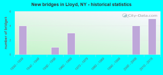
- New bridges - historical statistics
- 41930-1939
- 11950-1959
- 31960-1969
- 42000-2009
- 52010-2019
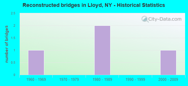
- Reconstructed bridges - Historical Statistics
- 11960-1969
- 01970-1979
- 21980-1989
- 01990-1999
- 12000-2009
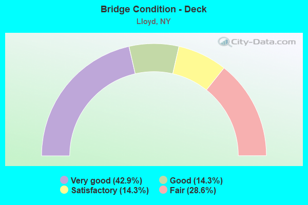
- Bridge Condition - Deck
- 42.9%Very good
- 14.3%Good
- 14.3%Satisfactory
- 28.6%Fair
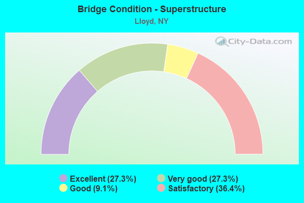
- Bridge Condition - Superstructure
- 27.3%Excellent
- 27.3%Very good
- 9.1%Good
- 36.4%Satisfactory
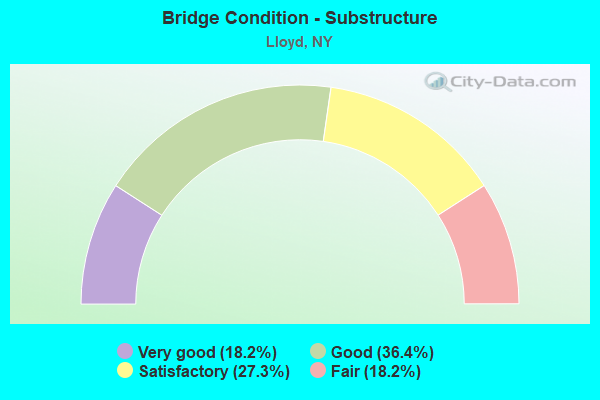
- Bridge Condition - Substructure
- 18.2%Very good
- 36.4%Good
- 27.3%Satisfactory
- 18.2%Fair
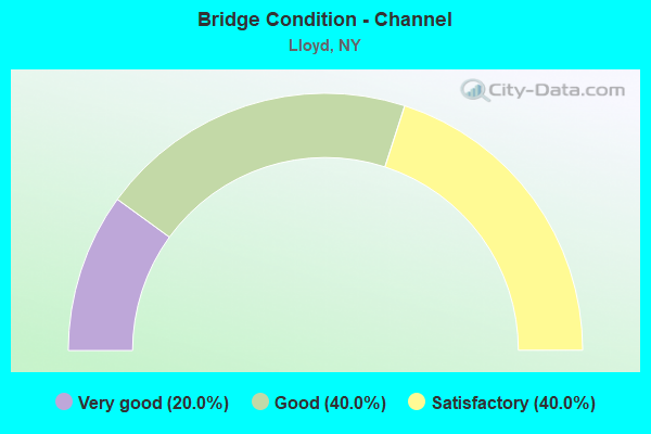
- Bridge Condition - Channel
- 20.0%Very good
- 40.0%Good
- 40.0%Satisfactory
Find on map >> Show street view
Structure Number: 100731, Location: 2.1 MI S JCT US9W & SH299 (Lat: 41.712453, Lng: -73.964258), Route carried "on" structure: US 9W, Year Built: 1930, Year Reconstructed: 1966, Status: Open, Structure Length: 2.47m (8.10ft), Average Daily Traffic: 24,872 (year 2017), Truck Traffic: 6%, Average Future Daily Traffic: 24,988 (year 2040), Design Load: H 20, Features Intersected: Hudson Valley Trail
Minimum Vertical Clearance: 30+ m (98+ ft), Kilometerpoint: 14.529, Lanes on structure: 5, Base Highway Network: Yes, Owner: State Highway Agency, Approaching Roadway Width: 18.0m (59.1ft), Skew: 3 degrees, Material/Design: Prestressed concrete, Design/Construction: Box Beam or Girders - Multiple, Number Of Spans In Main Unit: 1, Length of Maximum Span: 22.8m (74.8ft), Curb or Sidewalk Widths: Left: 3.3m (10.8ft), Right: 1.8m (5.9ft), Curb-To-Curb Width: 18.0m (59.1ft), Out-to-Out Width: 24.2m (79.4ft)
Condition: Deck: Fair, Superstructure: Satisfactory, Substructure: Satisfactory, Operating Rating: 62.1 metric tons, Method Used To Determine Operating Rating: Field evaluation and documented engineering judgment, Inventory Rating: 23.9 metric tons, Method Used To Determine Inventory Rating: Field evaluation and documented engineering judgment, Structural Evaluation: Somewhat better than minimum adequacy, Deck Geometry: High priority of replacement, Approach Roadway Alignment: Equal to present desirable criteria, Length Of Structure Improvement: 2.46m (8.07ft), Designated Inspection Frequency: Every 24 months, Inspection Date: March 2021, Bridge Improvement Cost: $2,074,000, Roadway Improvement Cost: $1,214,000, Total Project Cost: $3,288,000 ( Estimate for 2021), Wearing Surface/Protective System: Wearing Surface: Bituminous, Membrane: Other
Find on map >> Show street view
Structure Number: 100732, Location: 1.5 MI S JCT RTS 9W+299 (Lat: 41.721047, Lng: -73.960822), Route carried "on" structure: US 9W, Year Built: 2009, Status: Open, Structure Length: 10.76m (35.30ft), Average Daily Traffic: 22,061 (year 2017), Truck Traffic: 5%, Average Future Daily Traffic: 22,164 (year 2040), Design Load: HS 25 or greater, Features Intersected: VINEYARD AVENUE, TWAALFS
Minimum Vertical Clearance: 30+ m (98+ ft), Kilometerpoint: 15.430, Lanes on structure: 4, Lanes under structure: 2, Base Highway Network: Yes, Owner: State Highway Agency, Approaching Roadway Width: 18.0m (59.1ft), Skew: 25 degrees, Material/Design: Steel continuous, Design/Construction: Stringer/Multi-beam, Number Of Spans In Main Unit: 2, Length of Maximum Span: 59.2m (194.2ft), Curb-To-Curb Width: 19.2m (63.0ft), Out-to-Out Width: 20.1m (65.9ft)
Condition: Deck: Very good, Superstructure: Excellent, Substructure: Good, Channel: Good, Operating Rating: 86.2 metric tons, Method Used To Determine Operating Rating: Load Factor (LF), Inventory Rating: 51.7 metric tons, Method Used To Determine Inventory Rating: Load Factor (LF), Structural Evaluation: Better than present minimum criteria, Deck Geometry: Equal to present minimum criteria, Underclear: High priority of corrective action, Waterway Adequacy: Somewhat better than minimum adequacy, Approach Roadway Alignment: Meets minimum limits, Length Of Structure Improvement: 10.75m (35.27ft), Designated Inspection Frequency: Every 24 months, Inspection Date: May 2021, Bridge Improvement Cost: $10,923,000, Roadway Improvement Cost: $6,397,000, Total Project Cost: $17,320,000 ( Estimate for 2021), Deck Structure Type: Concrete Cast-file-Place, Wearing Surface/Protective System: Wearing Surface: Monolithic Concrete, Deck Protection: Epoxy Coated Reinforcing
Find on map >> Show street view
Structure Number: 100732A, Location: 1.5 MI S JCT RTS 9W+299 (Lat: 41.719944, Lng: -73.961347), Route carried "on" structure: US 9, Year Built: 2009, Status: Open, Structure Length: 2.35m (7.71ft), Average Daily Traffic: 22,061 (year 2017), Truck Traffic: 5%, Average Future Daily Traffic: 22,164 (year 2040), Design Load: HS 25 or greater, Features Intersected: OTHER
Minimum Vertical Clearance: 32.69m (107.25ft), Kilometerpoint: 15.414, Lanes on structure: 1, Owner: State Highway Agency, Approaching Roadway Width: 4.9m (16.1ft), Material/Design: Concrete continuous, Design/Construction: Slab, Number Of Spans In Main Unit: 4, Length of Maximum Span: 6.1m (20.0ft), Curb-To-Curb Width: 4.9m (16.1ft), Out-to-Out Width: 5.3m (17.4ft)
Condition: Deck: Very good, Superstructure: Very good, Substructure: Good, Operating Rating: 63.5 metric tons, Method Used To Determine Operating Rating: Load Factor (LF), Inventory Rating: 38.1 metric tons, Method Used To Determine Inventory Rating: Load Factor (LF), Structural Evaluation: Better than present minimum criteria, Deck Geometry: High priority of replacement, Approach Roadway Alignment: Meets minimum limits, Length Of Structure Improvement: 2.34m (7.68ft), Designated Inspection Frequency: Every 24 months, Inspection Date: May 2021, Bridge Improvement Cost: $382,000, Roadway Improvement Cost: $224,000, Total Project Cost: $606,000 ( Estimate for 2021), Wearing Surface/Protective System: Wearing Surface: Monolithic Concrete
Find on map >> Show street view
Structure Number: 104525, Location: 1.1 MI W JCT RTS 299+9W (Lat: 41.745167, Lng: -73.985022), Route carried "on" structure: State highway 299, Year Built: 1959, Year Reconstructed: 1994, Status: Open, Structure Length: 2.74m (8.99ft), Average Daily Traffic: 15,970 (year 2017), Truck Traffic: 6%, Average Future Daily Traffic: 16,045 (year 2040), Design Load: H 20, Features Intersected: BLACK CREEK
Minimum Vertical Clearance: 30+ m (98+ ft), Kilometerpoint: 15.591, Lanes on structure: 2, Base Highway Network: Yes, Owner: State Highway Agency, Approaching Roadway Width: 11.6m (38.1ft), Skew: 22 degrees, Material/Design: Steel, Design/Construction: Stringer/Multi-beam, Number Of Spans In Main Unit: 1, Length of Maximum Span: 26.2m (86.0ft), Curb-To-Curb Width: 16.8m (55.1ft), Out-to-Out Width: 17.6m (57.7ft)
Condition: Deck: Satisfactory, Superstructure: Good, Substructure: Satisfactory, Channel: Good, Operating Rating: 95.6 metric tons, Method Used To Determine Operating Rating: Load and Resistance Factor Rating (LRFR) rating reported by rating factor(RF) method using HL-93 loadings, Inventory Rating: 73.9 metric tons, Method Used To Determine Inventory Rating: Load and Resistance Factor Rating (LRFR) rating reported by rating factor(RF) method using HL-93 loadings, Structural Evaluation: Equal to present minimum criteria, Deck Geometry: Superior to present desirable criteria, Waterway Adequacy: Superior to present desirable criteria, Approach Roadway Alignment: Equal to present desirable criteria, Length Of Structure Improvement: 2.74m (8.99ft), Designated Inspection Frequency: Every 24 months, Inspection Date: June 2020, Bridge Improvement Cost: $2,232,000, Roadway Improvement Cost: $1,307,000, Total Project Cost: $3,540,000 ( Estimate for 2021), Deck Structure Type: Concrete Cast-file-Place, Wearing Surface/Protective System: Wearing Surface: Other, Deck Protection: Epoxy Coated Reinforcing
Find on map >> Show street view
Structure Number: 226423, Location: AT HIGHLAND (Lat: 41.718542, Lng: -73.954706), Route carried "on" structure: Other road , Year Built: 2006, Status: Open, Structure Length: 0.82m (2.69ft), Truck Traffic: 4%, Design Load: HS 25 or greater, Features Intersected: TWAALFSKILL CREEK, Facility Carried by Structure: RIVER ROAD
Minimum Vertical Clearance: 30+ m (98+ ft), Kilometerpoint: 0.724, Lanes on structure: 2, Owner: Town or Township Highway Agency, Approaching Roadway Width: 6.7m (22.0ft), Skew: 4 degrees, Material/Design: Concrete, Design/Construction: Frame, Number Of Spans In Main Unit: 1, Length of Maximum Span: 7.3m (24.0ft), Curb-To-Curb Width: 8.0m (26.2ft), Out-to-Out Width: 8.8m (28.9ft)
Condition: Deck: Very good, Superstructure: Very good, Substructure: Good, Channel: Satisfactory, Operating Rating: 78.9 metric tons, Method Used To Determine Operating Rating: Load Factor (LF), Inventory Rating: 47.2 metric tons, Method Used To Determine Inventory Rating: Load Factor (LF), Structural Evaluation: Better than present minimum criteria, Deck Geometry: Equal to present minimum criteria, Waterway Adequacy: Equal to present desirable criteria, Approach Roadway Alignment: Somewhat better than minimum adequacy, Length Of Structure Improvement: 0.82m (2.69ft), Designated Inspection Frequency: Every 24 months, Inspection Date: December 2020, Bridge Improvement Cost: $591,000, Roadway Improvement Cost: $346,000, Total Project Cost: $937,000 ( Estimate for 2021)
Find on map >> Show street view
Structure Number: 227053, Location: 0.12 MI NE JCT 9W & Havil (Lat: 41.711239, Lng: -73.962869), Route carried "on" structure: Other road , Year Built: 2010, Status: Open, Structure Length: 0.88m (2.89ft), Average Daily Traffic: 348 (year 2019), Truck Traffic: 5%, Average Future Daily Traffic: 487 (year 2039), Design Load: HL 93, Features Intersected: Hudson Valley Rail Trail, Facility Carried by Structure: MILE HILL ROAD
Minimum Vertical Clearance: 30+ m (98+ ft), Kilometerpoint: 0.080, Lanes on structure: 2, Owner: Town or Township Highway Agency, Approaching Roadway Width: 7.3m (24.0ft), Material/Design: Concrete, Design/Construction: Frame, Number Of Spans In Main Unit: 1, Length of Maximum Span: 8.5m (27.9ft), Curb-To-Curb Width: 7.3m (24.0ft), Out-to-Out Width: 8.5m (27.9ft)
Condition: Superstructure: Excellent, Substructure: Very good, Operating Rating: 77.8 metric tons, Method Used To Determine Operating Rating: Load and Resistance Factor Rating (LRFR) rating reported by rating factor(RF) method using HL-93 loadings, Inventory Rating: 58.3 metric tons, Method Used To Determine Inventory Rating: Load and Resistance Factor Rating (LRFR) rating reported by rating factor(RF) method using HL-93 loadings, Structural Evaluation: Equal to present desirable criteria, Deck Geometry: Somewhat better than minimum adequacy, Approach Roadway Alignment: Equal to present desirable criteria, Length Of Structure Improvement: 0.88m (2.89ft), Designated Inspection Frequency: Every 24 months, Inspection Date: August 2020, Bridge Improvement Cost: $508,000, Roadway Improvement Cost: $297,000, Total Project Cost: $805,000 ( Estimate for 2021)
Find on map >> Show street view
Structure Number: 322427, Location: 4.0 MI E OF NEW PALTZ (Lat: 41.736822, Lng: -74.006200), Route carried "on" structure: County highway , Year Built: 2011, Status: Open, Structure Length: 0.98m (3.22ft), Average Daily Traffic: 3,267 (year 2018), Truck Traffic: 4%, Average Future Daily Traffic: 4,042 (year 2040), Design Load: HS 25 or greater, Features Intersected: Hudson Valley Rail Trail, Facility Carried by Structure: County Road 12
Minimum Vertical Clearance: 30+ m (98+ ft), Kilometerpoint: 0.901, Lanes on structure: 2, Owner: County Highway Agency, Approaching Roadway Width: 7.0m (23.0ft), Skew: 4 degrees, Material/Design: Aluminum, Iron, Design/Construction: Arch - Deck, Number Of Spans In Main Unit: 1, Length of Maximum Span: 9.3m (30.5ft), Curb-To-Curb Width: 9.0m (29.5ft), Out-to-Out Width: 9.4m (30.8ft)
Condition: Superstructure: Very good, Substructure: Very good, Operating Rating: 79.3 metric tons, Method Used To Determine Operating Rating: Field evaluation and documented engineering judgment, Inventory Rating: 40.8 metric tons, Method Used To Determine Inventory Rating: Field evaluation and documented engineering judgment, Structural Evaluation: Equal to present desirable criteria, Deck Geometry: Meets minimum limits, Approach Roadway Alignment: Equal to present desirable criteria, Length Of Structure Improvement: 0.97m (3.18ft), Designated Inspection Frequency: Every 24 months, Inspection Date: July 2021, Bridge Improvement Cost: $2,166,000, Roadway Improvement Cost: $1,269,000, Total Project Cost: $3,435,000 ( Estimate for 2021)
Find on map >> Show street view
Structure Number: 322428, Location: 1.3 MI E OF HIGHLAND VILL (Lat: 41.735206, Lng: -73.980775), Route carried "on" structure: County highway , Year Built: 2011, Status: Open, Structure Length: 0.98m (3.22ft), Average Daily Traffic: 3,041 (year 2018), Truck Traffic: 4%, Average Future Daily Traffic: 3,762 (year 2040), Design Load: HS 25 or greater, Features Intersected: Hudson Valley Rail Trail, Facility Carried by Structure: NEW PALTZ ROAD CR
Minimum Vertical Clearance: 30+ m (98+ ft), Kilometerpoint: 3.298, Lanes on structure: 2, Owner: County Highway Agency, Approaching Roadway Width: 9.1m (29.9ft), Skew: 3 degrees, Material/Design: Aluminum, Iron, Design/Construction: Arch - Deck, Number Of Spans In Main Unit: 1, Length of Maximum Span: 9.3m (30.5ft), Curb-To-Curb Width: 8.8m (28.9ft), Out-to-Out Width: 30.5m (100.1ft)
Condition: Superstructure: Excellent, Substructure: Good, Operating Rating: 79.3 metric tons, Method Used To Determine Operating Rating: Field evaluation and documented engineering judgment, Inventory Rating: 40.8 metric tons, Method Used To Determine Inventory Rating: Field evaluation and documented engineering judgment, Structural Evaluation: Better than present minimum criteria, Deck Geometry: Meets minimum limits, Approach Roadway Alignment: Equal to present desirable criteria, Length Of Structure Improvement: 0.97m (3.18ft), Designated Inspection Frequency: Every 24 months, Inspection Date: July 2021, Bridge Improvement Cost: $1,992,000, Roadway Improvement Cost: $1,166,000, Total Project Cost: $3,158,000 ( Estimate for 2021)
Find on map >> Show street view
Structure Number: 336522, Location: 4 MI E OF NEW PALTZ (Lat: 41.733975, Lng: -74.004594), Route carried "on" structure: County highway , Year Built: 1963, Status: Open, Structure Length: 0.76m (2.49ft), Average Daily Traffic: 1,524 (year 2020), Truck Traffic: 5%, Average Future Daily Traffic: 2,134 (year 2040), Features Intersected: BLACK CREEK, Facility Carried by Structure: PANCAKE HOLLOW RD
Minimum Vertical Clearance: 30+ m (98+ ft), Kilometerpoint: 4.891, Lanes on structure: 2, Owner: County Highway Agency, Approaching Roadway Width: 8.5m (27.9ft), Skew: 2 degrees, Material/Design: Concrete, Design/Construction: Slab, Number Of Spans In Main Unit: 1, Length of Maximum Span: 6.7m (22.0ft), Curb-To-Curb Width: 8.5m (27.9ft), Out-to-Out Width: 9.1m (29.9ft)
Condition: Superstructure: Satisfactory, Substructure: Fair, Channel: Satisfactory, Operating Rating: 52.5 metric tons, Method Used To Determine Operating Rating: Load and Resistance Factor Rating (LRFR) rating reported by rating factor(RF) method using HL-93 loadings, Inventory Rating: 40.5 metric tons, Method Used To Determine Inventory Rating: Load and Resistance Factor Rating (LRFR) rating reported by rating factor(RF) method using HL-93 loadings, Structural Evaluation: Somewhat better than minimum adequacy, Deck Geometry: Somewhat better than minimum adequacy, Waterway Adequacy: Superior to present desirable criteria, Approach Roadway Alignment: Somewhat better than minimum adequacy, Length Of Structure Improvement: 0.76m (2.49ft), Designated Inspection Frequency: Every 24 months, Inspection Date: August 2020, Bridge Improvement Cost: $362,000, Roadway Improvement Cost: $212,000, Total Project Cost: $574,000 ( Estimate for 2021), Wearing Surface/Protective System: Wearing Surface: Bituminous
Find on map >> Show street view
Structure Number: 337148, Location: So of Rt 299 at Riverside (Lat: 41.736664, Lng: -74.002139), Route carried "on" structure: County highway , Year Built: 2018, Status: Open, Structure Length: 0.76m (2.49ft), Average Daily Traffic: 626 (year 2020), Truck Traffic: 3%, Average Future Daily Traffic: 876 (year 2040), Design Load: HL 93, Features Intersected: Hudson Valley Rail Trail, Facility Carried by Structure: County Road 15
Minimum Vertical Clearance: 32.69m (107.25ft), Kilometerpoint: 0.225, Lanes on structure: 2, Owner: County Highway Agency, Approaching Roadway Width: 7.3m (24.0ft), Skew: 1 degrees, Material/Design: Steel, Design/Construction: Culvert, Number Of Spans In Main Unit: 1, Length of Maximum Span: 7.0m (23.0ft), Curb-To-Curb Width: 9.8m (32.2ft), Out-to-Out Width: 11.1m (36.4ft)
Condition: Culverts: Excellent, Operating Rating: 77.6 metric tons, Method Used To Determine Operating Rating: Field evaluation and documented engineering judgment, Inventory Rating: 40.8 metric tons, Method Used To Determine Inventory Rating: Field evaluation and documented engineering judgment, Structural Evaluation: Superior to present desirable criteria, Deck Geometry: Equal to present minimum criteria, Approach Roadway Alignment: Equal to present desirable criteria, Length Of Structure Improvement: 0.76m (2.49ft), Designated Inspection Frequency: Every 24 months, Inspection Date: December 2020, Bridge Improvement Cost: $239,000, Roadway Improvement Cost: $140,000, Total Project Cost: $378,000 ( Estimate for 2021)
Find on map >> Show street view
Structure Number: 502553, Location: JCT RTS 44-55 < HUDSON R (Lat: 41.703375, Lng: -73.950567), Route carried "on" structure: US 44, Year Built: 1930, Year Reconstructed: 1991, Status: Posted for load, Structure Length: 128.05m (420.11ft), Average Daily Traffic: 34,647 (year 2020), Truck Traffic: 4%, Average Future Daily Traffic: 48,876 (year 2040), Features Intersected: AMTRAK, Gerald Drive, Ri
Minimum Vertical Clearance: 4.80m (15.75ft), Kilometerpoint: 0.000, Lanes on structure: 2, Lanes under structure: 6, Base Highway Network: Yes, Toll: Toll bridge, Owner: State Toll Authority, Approaching Roadway Width: 15.2m (49.9ft), Navigation Control: Yes ( Vertical Clearance: 41.7m (136.8ft), Horizontal Clearance: 147.8m (484.9ft)), Material/Design: Steel continuous, Design/Construction: Suspension, Number Of Spans In Main Unit: 3, Number Of Approach Spans: 26, Length of Maximum Span: 455.6m (1,494.8ft), Curb or Sidewalk Widths: Left: 1.2m (3.9ft), Right: 1.2m (3.9ft), Curb-To-Curb Width: 9.4m (30.8ft), Out-to-Out Width: 10.4m (34.1ft)
Condition: Deck: Fair, Superstructure: Satisfactory, Substructure: Fair, Channel: Very good, Operating Rating: 73.2 metric tons, Method Used To Determine Operating Rating: Field evaluation and documented engineering judgment, Inventory Rating: 29.4 metric tons, Method Used To Determine Inventory Rating: Field evaluation and documented engineering judgment, Structural Evaluation: Somewhat better than minimum adequacy, Deck Geometry: High priority of corrective action, Underclear: High priority of corrective action, Waterway Adequacy: Equal to present minimum criteria, Approach Roadway Alignment: Meets minimum limits, Length Of Structure Improvement: 128.04m (420.08ft), Designated Inspection Frequency: Every 24 months, Critical Feature Inspection Frequency: Every 24 months, Underwater Inspection Frequency: Every 60 months, Inspection Date: June 2020, Critical Feature Inspection Date: June 2020, Underwater Inspection Date: June 2017, Bridge Improvement Cost: $124,185,000, Roadway Improvement Cost: $72,723,000, Total Project Cost: $196,908,000 ( Estimate for 2021), Deck Structure Type: Concrete Cast-file-Place, Wearing Surface/Protective System: Wearing Surface: Bituminous, Membrane: Other
Find on map >> Show street view
Structure Number: 505445, Location: JCT RTS 44-55 < 9W (Lat: 41.707603, Lng: -73.966403), Route carried "on" structure: US 44, Year Built: 1966, Year Reconstructed: 2005, Status: Posted for load, Structure Length: 4.30m (14.11ft), Average Daily Traffic: 33,126 (year 2020), Truck Traffic: 4%, Average Future Daily Traffic: 46,730 (year 2040), Design Load: HS 20, Features Intersected: RTE 9W
Minimum Vertical Clearance: 30+ m (98+ ft), Kilometerpoint: 45.631, Lanes on structure: 2, Lanes under structure: 5, Base Highway Network: Yes, Toll: Toll bridge, Owner: State Toll Authority, Approaching Roadway Width: 14.0m (45.9ft), Skew: 20 degrees, Material/Design: Steel, Design/Construction: Stringer/Multi-beam, Number Of Spans In Main Unit: 1, Length of Maximum Span: 41.4m (135.8ft), Curb-To-Curb Width: 9.8m (32.2ft), Out-to-Out Width: 11.8m (38.7ft)
Condition: Deck: Good, Superstructure: Satisfactory, Substructure: Satisfactory, Operating Rating: 89.8 metric tons, Method Used To Determine Operating Rating: Allowable Stress (AS), Inventory Rating: 58.1 metric tons, Method Used To Determine Inventory Rating: Allowable Stress (AS), Structural Evaluation: Equal to present minimum criteria, Deck Geometry: Meets minimum limits, Underclear: Somewhat better than minimum adequacy, Approach Roadway Alignment: Equal to present desirable criteria, Length Of Structure Improvement: 4.29m (14.07ft), Designated Inspection Frequency: Every 24 months, Inspection Date: June 2020, Bridge Improvement Cost: $2,438,000, Roadway Improvement Cost: $1,427,000, Total Project Cost: $3,865,000 ( Estimate for 2021), Deck Structure Type: Concrete Cast-file-Place, Wearing Surface/Protective System: Wearing Surface: Bituminous, Membrane: Other
Find on map >> Show street view
Structure Number: 100732, Location: 1.5 MI S JCT RTS 9W+299 (Lat: 41.721047, Lng: -73.960822), Route carried "under" structure: Business City street , Year Built: 2009, Structure Length: 0. m, Features Intersected: VINEYARD AVENUE, TWAALFS, Facility Carried by Structure: RTE 9W
Minimum Vertical Clearance: 4.74m (15.55ft), Kilometerpoint: 0.000, Lanes on structure: 4, Lanes under structure: 2, Material/Design: Steel continuous, Design/Construction: Stringer/Multi-beam, Length of Maximum Span: 59.2m (194.2ft)
Find on map >> Show street view
Structure Number: 227052, Location: 2 MI NW JCT 9W & Haviland (Lat: 41.717231, Lng: -73.968111), Route carried "under" structure: State highway , Year Built: 2010, Structure Length: 0. m, Features Intersected: 44 86011273, TWAALFSKILL, Facility Carried by Structure: RTE 44
Minimum Vertical Clearance: 5.51m (18.08ft), Kilometerpoint: 11.746, Lanes under structure: 2, Material/Design: Steel, Design/Construction: Truss - Thru, Length of Maximum Span: 38.1m (125.0ft)
Find on map >> Show street view
Structure Number: 502553, Location: JCT RTS 44-55 < HUDSON R (Lat: 41.703375, Lng: -73.950567), Route carried "under" structure: US 9, Year Built: 1930, Structure Length: 0. m, Average Daily Traffic: 30,382 (year 1999), Features Intersected: AMTRAK, Gerald Drive, Ri, Facility Carried by Structure: RTE 44
Minimum Vertical Clearance: 4.75m (15.58ft), Kilometerpoint: 2.735, Lanes on structure: 2, Lanes under structure: 2, Material/Design: Steel continuous, Design/Construction: Suspension, Length of Maximum Span: 455.6m (1,494.8ft)
Find on map >> Show street view
Structure Number: 502553, Location: JCT RTS 44-55 < HUDSON R (Lat: 41.703375, Lng: -73.950567), Route carried "under" structure: ServiceCity street , Year Built: 1930, Structure Length: 0. m, Average Daily Traffic: 500 (year 2006), Features Intersected: AMTRAK, Gerald Drive, Ri, Facility Carried by Structure: RTE 44
Minimum Vertical Clearance: 3.71m (12.17ft), Kilometerpoint: 0.000, Lanes on structure: 2, Lanes under structure: 2, Material/Design: Steel continuous, Design/Construction: Suspension, Length of Maximum Span: 455.6m (1,494.8ft)
Find on map >> Show street view
Structure Number: 505445, Location: JCT RTS 44-55 < 9W (Lat: 41.707603, Lng: -73.966403), Route carried "under" structure: US 9W, Year Built: 1966, Structure Length: 0. m, Average Daily Traffic: 23,723 (year 1999), Features Intersected: RTE 9W, Facility Carried by Structure: RTE 44
Minimum Vertical Clearance: 4.72m (15.49ft), Kilometerpoint: 14.159, Lanes on structure: 2, Lanes under structure: 5, Material/Design: Steel, Design/Construction: Stringer/Multi-beam, Length of Maximum Span: 41.4m (135.8ft)