Bridge Statistics for Logan, Iowa (IA)
Condition, Traffic, Stress, Structural Evaluation, Project Costs
- National Bridge Inventory (NBI) Statistics
- 12Number of bridges
- 161ft / 49.0mTotal length
- 17,898Total average daily traffic
- 3,239Total average daily truck traffic
- National Bridge Inventory (NBI) Registered Bridges for Logan
- No street view available for this location
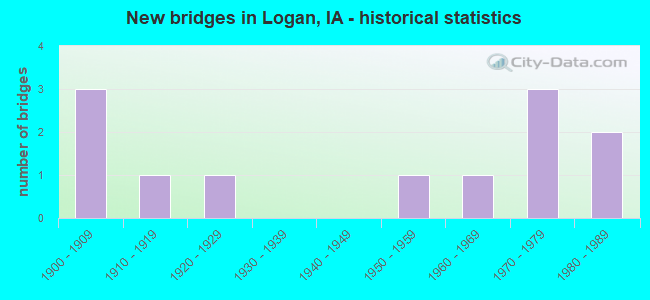
- New bridges - historical statistics
- 31900-1909
- 11910-1919
- 11920-1929
- 11950-1959
- 11960-1969
- 31970-1979
- 21980-1989


- Bridge Condition - Deck
- 25.0%Good
- 12.5%Satisfactory
- 50.0%Fair
- 12.5%Failed

- Bridge Condition - Superstructure
- 37.5%Good
- 12.5%Satisfactory
- 25.0%Fair
- 25.0%Failed

- Bridge Condition - Substructure
- 12.5%Very good
- 12.5%Good
- 12.5%Satisfactory
- 25.0%Fair
- 12.5%Serious
- 12.5%Critical
- 12.5%Failed

- Bridge Condition - Channel
- 18.2%Good
- 27.3%Satisfactory
- 18.2%Fair
- 9.1%Poor
- 18.2%Serious
- 9.1%Failed

- Bridge Condition - Culverts
- 33.3%Good
- 66.7%Fair
Find on map >> Show street view
Structure Number: 27421, Location: 2.5 MI. W OF JCT. 127 (Lat: 41.611186, Lng: -95.822417), Route carried "on" structure: US 30, Year Built: 1983, Status: Open, Structure Length: 3.44m (11.29ft), Average Daily Traffic: 6,100 (year 2020), Truck Traffic: 18%, Average Future Daily Traffic: 6,100 (year 2041), Design Load: HS 20, Features Intersected: HOG CREEK
Minimum Vertical Clearance: 30+ m (98+ ft), Kilometerpoint: 26.351, Lanes on structure: 2, Base Highway Network: Yes, Owner: State Highway Agency, Approaching Roadway Width: 13.4m (44.0ft), Skew: 1 degrees, Material/Design: Concrete continuous, Design/Construction: Slab, Number Of Spans In Main Unit: 3, Length of Maximum Span: 13.1m (43.0ft), Curb-To-Curb Width: 13.4m (44.0ft), Out-to-Out Width: 14.4m (47.2ft)
Condition: Deck: Satisfactory, Superstructure: Satisfactory, Substructure: Very good, Channel: Good, Operating Rating: 48.5 metric tons, Method Used To Determine Operating Rating: Allowable Stress (AS), Inventory Rating: 22.5 metric tons, Method Used To Determine Inventory Rating: Allowable Stress (AS), Structural Evaluation: Somewhat better than minimum adequacy, Deck Geometry: Equal to present minimum criteria, Waterway Adequacy: Equal to present desirable criteria, Approach Roadway Alignment: Better than present minimum criteria, Designated Inspection Frequency: Every 24 months, Inspection Date: July 2021, Deck Structure Type: Concrete Cast-file-Place, Wearing Surface/Protective System: Wearing Surface: Monolithic Concrete, Deck Protection: Epoxy Coated Reinforcing
Find on map >> Show street view
Structure Number: 27431, Location: 0.3 mi. E of IA 127 (Lat: 41.643008, Lng: -95.784544), Route carried "on" structure: US 30, Year Built: 1973, Status: Open, Structure Length: 23.84m (78.22ft), Average Daily Traffic: 5,400 (year 2020), Truck Traffic: 18%, Average Future Daily Traffic: 5,400 (year 2041), Design Load: HS 20, Features Intersected: BOYER RVR & CC RR & ROAD
Minimum Vertical Clearance: 30+ m (98+ ft), Kilometerpoint: 31.430, Lanes on structure: 2, Lanes under structure: 2, Base Highway Network: Yes, Owner: State Highway Agency, Approaching Roadway Width: 13.4m (44.0ft), Material/Design: Prestressed concrete, Design/Construction: Stringer/Multi-beam, Number Of Spans In Main Unit: 9, Length of Maximum Span: 29.3m (96.1ft), Curb or Sidewalk Widths: Left: 0.3m (1.0ft), Right: 0.3m (1.0ft), Curb-To-Curb Width: 13.4m (44.0ft), Out-to-Out Width: 14.5m (47.6ft)
Condition: Deck: Good, Superstructure: Good, Substructure: Satisfactory, Channel: Satisfactory, Operating Rating: 81.2 metric tons, Method Used To Determine Operating Rating: Load Factor (LF), Inventory Rating: 30.4 metric tons, Method Used To Determine Inventory Rating: Load Factor (LF), Structural Evaluation: Equal to present minimum criteria, Deck Geometry: Equal to present minimum criteria, Underclear: Meets minimum limits, Waterway Adequacy: Equal to present desirable criteria, Approach Roadway Alignment: Equal to present minimum criteria, Designated Inspection Frequency: Every 24 months, Inspection Date: August 2021, Deck Structure Type: Concrete Cast-file-Place, Wearing Surface/Protective System: Wearing Surface: Low Slump Concrete
Find on map >> Show street view
Structure Number: 2744, Location: 0.4 mi. E. of S.R. L-34 (Lat: 41.643533, Lng: -95.772506), Route carried "on" structure: US 30, Year Built: 1929, Status: Open, Structure Length: 1.22m (4.00ft), Average Daily Traffic: 4,320 (year 2020), Truck Traffic: 23%, Average Future Daily Traffic: 4,320 (year 2041), Design Load: HS 20, Features Intersected: NATURAL CREEK
Minimum Vertical Clearance: 30+ m (98+ ft), Kilometerpoint: 32.435, Lanes on structure: 2, Base Highway Network: Yes, Owner: State Highway Agency, Approaching Roadway Width: 12.4m (40.7ft), Material/Design: Concrete, Design/Construction: Culvert, Number Of Spans In Main Unit: 1, Length of Maximum Span: 12.2m (40.0ft)
Condition: Channel: Good, Culverts: Good, Operating Rating: 43.5 metric tons, Method Used To Determine Operating Rating: Allowable Stress (AS), Inventory Rating: 32.7 metric tons, Method Used To Determine Inventory Rating: Allowable Stress (AS), Structural Evaluation: Better than present minimum criteria, Waterway Adequacy: Equal to present minimum criteria, Approach Roadway Alignment: Somewhat better than minimum adequacy, Designated Inspection Frequency: Every 24 months, Inspection Date: July 2021
Find on map >> Show street view
Structure Number: 17753, Location: 078430308 (Lat: 41.593528, Lng: -95.776975), Route carried "on" structure: County highway , Year Built: 1963, Status: Open, Structure Length: 1.37m (4.49ft), Average Daily Traffic: 790 (year 2016), Truck Traffic: 15%, Average Future Daily Traffic: 790 (year 2040), Features Intersected: HARRIS GROVE CREEK, Facility Carried by Structure: FM OVERTON AVE
Minimum Vertical Clearance: 30+ m (98+ ft), Kilometerpoint: 11.507, Lanes on structure: 2, Owner: County Highway Agency, Approaching Roadway Width: 9.1m (29.9ft), Skew: 2 degrees, Material/Design: Prestressed concrete, Design/Construction: Stringer/Multi-beam, Number Of Spans In Main Unit: 1, Length of Maximum Span: 13.1m (43.0ft), Curb or Sidewalk Widths: Left: 0.3m (1.0ft), Right: 0.3m (1.0ft), Curb-To-Curb Width: 7.3m (24.0ft), Out-to-Out Width: 7.9m (25.9ft)
Condition: Deck: Fair, Superstructure: Good, Substructure: Fair, Channel: Fair, Operating Rating: 37.7 metric tons, Method Used To Determine Operating Rating: Allowable Stress (AS), Inventory Rating: 24.3 metric tons, Method Used To Determine Inventory Rating: Allowable Stress (AS), Structural Evaluation: Somewhat better than minimum adequacy, Deck Geometry: Meets minimum limits, Waterway Adequacy: Better than present minimum criteria, Approach Roadway Alignment: Equal to present desirable criteria, Length Of Structure Improvement: 6.70m (21.98ft), Designated Inspection Frequency: Every 24 months, Inspection Date: December 2020, Bridge Improvement Cost: $100,000, Roadway Improvement Cost: $10,000, Deck Structure Type: Concrete Cast-file-Place, Wearing Surface/Protective System: Wearing Surface: Bituminous
Find on map >> Show street view
Structure Number: 17799, Location: 079420406 (Lat: 41.678436, Lng: -95.747894), Route carried "on" structure: County highway , Year Built: 1900, Status: Closed, Structure Length: 6.13m (20.11ft), Average Daily Traffic: 40 (year 2016), Average Future Daily Traffic: 40 (year 2040), Design Load: HS 20, Features Intersected: BOYER CREEK, Facility Carried by Structure: PARKER TRAIL
Minimum Vertical Clearance: 30+ m (98+ ft), Kilometerpoint: 2.478, Lanes on structure: 1, Owner: County Highway Agency, Approaching Roadway Width: 7.6m (24.9ft), Material/Design: Steel, Design/Construction: Truss - Thru, Number Of Spans In Main Unit: 3, Length of Maximum Span: 36.6m (120.1ft), Curb-To-Curb Width: 4.8m (15.7ft), Out-to-Out Width: 4.8m (15.7ft)
Condition: Deck: Fair, Superstructure: Failed, Substructure: Critical, Channel: Poor, Deck Geometry: Equal to present desirable criteria, Waterway Adequacy: Better than present minimum criteria, Approach Roadway Alignment: Equal to present minimum criteria, Bridge Posting: Required (Relationship of Operating Rating to Maximum Legal Load: > 39.9% below), Length Of Structure Improvement: 25.80m (84.65ft), Designated Inspection Frequency: Every 24 months, Critical Feature Inspection Frequency: Every 24 months, Inspection Date: December 2020, Critical Feature Inspection Date: December 2020, Bridge Improvement Cost: $387,000, Roadway Improvement Cost: $39,000, Deck Structure Type: Wood or Timber, Wearing Surface/Protective System: Wearing Surface: Wood or Timber
Find on map >> Show street view
Structure Number: 17802, Location: 079420904 (Lat: 41.667683, Lng: -95.741772), Route carried "on" structure: County highway , Year Built: 1916, Status: Open, Structure Length: 0.98m (3.22ft), Average Daily Traffic: 30 (year 2016), Average Future Daily Traffic: 30 (year 2040), Features Intersected: SMALL CREEK, Facility Carried by Structure: PARKER TRAIL
Minimum Vertical Clearance: 30+ m (98+ ft), Kilometerpoint: 0.806, Lanes on structure: 2, Owner: County Highway Agency, Approaching Roadway Width: 7.6m (24.9ft), Material/Design: Concrete, Design/Construction: Stringer/Multi-beam, Number Of Spans In Main Unit: 1, Length of Maximum Span: 9.4m (30.8ft), Curb or Sidewalk Widths: Left: 0.6m (2.0ft), Right: 0.6m (2.0ft), Curb-To-Curb Width: 7.4m (24.3ft), Out-to-Out Width: 8.0m (26.2ft)
Condition: Deck: Fair, Superstructure: Fair, Substructure: Serious, Channel: Serious, Operating Rating: 58.3 metric tons, Method Used To Determine Operating Rating: Allowable Stress (AS), Inventory Rating: 36.7 metric tons, Method Used To Determine Inventory Rating: Allowable Stress (AS), Structural Evaluation: High priority of corrective action, Deck Geometry: Equal to present minimum criteria, Waterway Adequacy: Somewhat better than minimum adequacy, Approach Roadway Alignment: Equal to present desirable criteria, Length Of Structure Improvement: 5.20m (17.06ft), Designated Inspection Frequency: Every 24 months, Inspection Date: December 2020, Bridge Improvement Cost: $79,000, Roadway Improvement Cost: $8,000, Deck Structure Type: Concrete Cast-file-Place, Wearing Surface/Protective System: Wearing Surface: Monolithic Concrete
Find on map >> Show street view
Structure Number: 17809, Location: 000000000 (Lat: 41.641731, Lng: -95.782869), Route carried "on" structure: City street , Year Built: 1900, Year Reconstructed: 1972, Status: Closed, Structure Length: 4.45m (14.60ft), Average Daily Traffic: 152 (year 1998), Average Future Daily Traffic: 152 (year 2031), Features Intersected: BOYER RIVER, Facility Carried by Structure: 8TH STREET
Minimum Vertical Clearance: 3.40m (11.15ft), Kilometerpoint: 0.858, Lanes on structure: 1, Owner: City or Municipal Highway Agency, Approaching Roadway Width: 8.5m (27.9ft), Material/Design: Steel, Design/Construction: Truss - Thru, Number Of Spans In Main Unit: 1, Number Of Approach Spans: 1, Length of Maximum Span: 37.5m (123.0ft), Curb-To-Curb Width: 4.9m (16.1ft), Out-to-Out Width: 5.1m (16.7ft)
Condition: Deck: Failed, Superstructure: Failed, Substructure: Failed, Channel: Failed, Bridge Posting: Required (Relationship of Operating Rating to Maximum Legal Load: 10.0 - 19.9% below), Length Of Structure Improvement: 23.40m (76.77ft), Designated Inspection Frequency: Every 24 months, Critical Feature Inspection Frequency: Every 24 months, Inspection Date: January 2011, Critical Feature Inspection Date: January 2011, Bridge Improvement Cost: $351,000, Roadway Improvement Cost: $53,000, Deck Structure Type: Wood or Timber, Wearing Surface/Protective System: Wearing Surface: Wood or Timber
Find on map >> Show street view
Structure Number: 17814, Location: 079431405 (Lat: 41.647606, Lng: -95.821469), Route carried "on" structure: County highway , Year Built: 1900, Status: Open, Structure Length: 0.64m (2.10ft), Average Daily Traffic: 70 (year 2016), Average Future Daily Traffic: 70 (year 2040), Features Intersected: HOG CREEK, Facility Carried by Structure: 242 TRAIL
Minimum Vertical Clearance: 30+ m (98+ ft), Kilometerpoint: 4.989, Lanes on structure: 2, Owner: County Highway Agency, Approaching Roadway Width: 9.8m (32.2ft), Material/Design: Concrete continuous, Design/Construction: Culvert, Number Of Spans In Main Unit: 2, Length of Maximum Span: 3.0m (9.8ft)
Condition: Channel: Satisfactory, Culverts: Fair, Operating Rating: 44.4 metric tons, Method Used To Determine Operating Rating: Allowable Stress (AS), Inventory Rating: 32.7 metric tons, Method Used To Determine Inventory Rating: Allowable Stress (AS), Structural Evaluation: Somewhat better than minimum adequacy, Waterway Adequacy: Equal to present minimum criteria, Approach Roadway Alignment: Equal to present desirable criteria, Designated Inspection Frequency: Every 24 months, Inspection Date: December 2020
Find on map >> Show street view
Structure Number: 178151, Location: 079431503 (Lat: 41.654092, Lng: -95.845464), Route carried "on" structure: County highway , Year Built: 1986, Status: Open, Structure Length: 5.09m (16.70ft), Average Daily Traffic: 60 (year 2016), Average Future Daily Traffic: 60 (year 2038), Design Load: HS 20, Features Intersected: WILLOW CREEK, Facility Carried by Structure: 242 TRAIL
Minimum Vertical Clearance: 30+ m (98+ ft), Kilometerpoint: 2.429, Lanes on structure: 2, Owner: County Highway Agency, Approaching Roadway Width: 11.0m (36.1ft), Skew: 1 degrees, Material/Design: Prestressed concrete, Design/Construction: Stringer/Multi-beam, Number Of Spans In Main Unit: 3, Length of Maximum Span: 18.0m (59.1ft), Curb or Sidewalk Widths: Left: 0.3m (1.0ft), Right: 0.3m (1.0ft), Curb-To-Curb Width: 9.1m (29.9ft), Out-to-Out Width: 9.8m (32.2ft)
Condition: Deck: Good, Superstructure: Good, Substructure: Good, Channel: Satisfactory, Operating Rating: 64.3 metric tons, Method Used To Determine Operating Rating: Allowable Stress (AS), Inventory Rating: 35.1 metric tons, Method Used To Determine Inventory Rating: Allowable Stress (AS), Structural Evaluation: Better than present minimum criteria, Deck Geometry: Better than present minimum criteria, Waterway Adequacy: Equal to present desirable criteria, Approach Roadway Alignment: Equal to present minimum criteria, Designated Inspection Frequency: Every 48 months, Inspection Date: December 2018, Deck Structure Type: Concrete Cast-file-Place, Wearing Surface/Protective System: Wearing Surface: Monolithic Concrete
Find on map >> Show street view
Structure Number: 17818, Location: 079432205 (Lat: 41.635058, Lng: -95.829839), Route carried "on" structure: County highway , Year Built: 1950, Status: Open, Structure Length: 0.88m (2.89ft), Average Daily Traffic: 420 (year 2016), Truck Traffic: 14%, Average Future Daily Traffic: 420 (year 2040), Design Load: H 20, Features Intersected: HOG CREEK, Facility Carried by Structure: 260TH ST
Minimum Vertical Clearance: 30+ m (98+ ft), Kilometerpoint: 20.973, Lanes on structure: 2, Owner: County Highway Agency, Approaching Roadway Width: 9.8m (32.2ft), Skew: 3 degrees, Material/Design: Concrete continuous, Design/Construction: Culvert, Number Of Spans In Main Unit: 2, Length of Maximum Span: 3.7m (12.1ft)
Condition: Channel: Serious, Culverts: Fair, Operating Rating: 44.4 metric tons, Method Used To Determine Operating Rating: Field evaluation and documented engineering judgment, Inventory Rating: 32.7 metric tons, Method Used To Determine Inventory Rating: Field evaluation and documented engineering judgment, Structural Evaluation: Somewhat better than minimum adequacy, Waterway Adequacy: Better than present minimum criteria, Approach Roadway Alignment: Equal to present minimum criteria, Length Of Structure Improvement: 4.60m (15.09ft), Designated Inspection Frequency: Every 24 months, Inspection Date: December 2020, Bridge Improvement Cost: $70,000, Roadway Improvement Cost: $7,000
Find on map >> Show street view
Structure Number: 178221, Location: 079433603 (Lat: 41.606744, Lng: -95.804189), Route carried "on" structure: County highway , Year Built: 1975, Status: Open, Structure Length: 1.01m (3.31ft), Average Daily Traffic: 30 (year 2016), Average Future Daily Traffic: 30 (year 2040), Features Intersected: HARRIS GROVE CREEK, Facility Carried by Structure: NILES TRAIL
Minimum Vertical Clearance: 30+ m (98+ ft), Kilometerpoint: 3.904, Lanes on structure: 2, Owner: County Highway Agency, Approaching Roadway Width: 9.1m (29.9ft), Material/Design: Steel, Design/Construction: Stringer/Multi-beam, Number Of Spans In Main Unit: 1, Length of Maximum Span: 9.4m (30.8ft), Curb-To-Curb Width: 9.1m (29.9ft), Out-to-Out Width: 9.1m (29.9ft)
Condition: Deck: Fair, Superstructure: Fair, Substructure: Fair, Channel: Fair, Operating Rating: 38.3 metric tons, Method Used To Determine Operating Rating: Load Factor (LF), Inventory Rating: 22.9 metric tons, Method Used To Determine Inventory Rating: Load Factor (LF), Structural Evaluation: Somewhat better than minimum adequacy, Deck Geometry: Better than present minimum criteria, Waterway Adequacy: Equal to present desirable criteria, Approach Roadway Alignment: Equal to present minimum criteria, Designated Inspection Frequency: Every 24 months, Inspection Date: December 2020, Deck Structure Type: Corrugated Steel, Wearing Surface/Protective System: Wearing Surface: Gravel
Find on map >> Show street view
Structure Number: 27431, Location: 0.3 mi. E of IA 127 (Lat: 41.643008, Lng: -95.784544), Route carried "under" structure: City street , Year Built: 1973, Structure Length: 0. m, Average Daily Traffic: 486 (year 1998), Features Intersected: BOYER RVR & CC RR & ROAD, Facility Carried by Structure: US 30
Minimum Vertical Clearance: 30+ m (98+ ft), Kilometerpoint: 0.116, Lanes on structure: 2, Lanes under structure: 2, Material/Design: Prestressed concrete, Design/Construction: Stringer/Multi-beam, Length of Maximum Span: 29.3m (96.1ft)