Bridge Statistics for Lombard, Illinois (IL)
Condition, Traffic, Stress, Structural Evaluation, Project Costs
- National Bridge Inventory (NBI) Statistics
- 33Number of bridges
- 223ft / 68.3mTotal length
- $3,582,000Total costs
- 1,320,800Total average daily traffic
- 99,789Total average daily truck traffic
- National Bridge Inventory (NBI) Registered Bridges for Lombard
- No street view available for this location
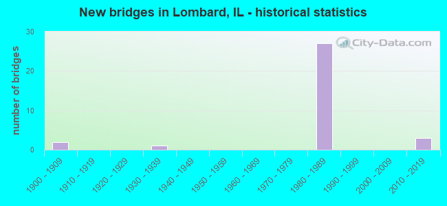
- New bridges - historical statistics
- 21900-1909
- 11930-1939
- 271980-1989
- 32010-2019


- Bridge Condition - Deck
- 8.3%Very good
- 8.3%Good
- 75.0%Satisfactory
- 8.3%Poor

- Bridge Condition - Superstructure
- 8.3%Very good
- 66.7%Good
- 8.3%Satisfactory
- 8.3%Fair
- 8.3%Serious

- Bridge Condition - Substructure
- 16.7%Very good
- 58.3%Good
- 16.7%Satisfactory
- 8.3%Fair

- Bridge Condition - Channel
- 50.0%Very good
- 50.0%Good
Find on map >> Show street view
Structure Number: 220076, Location: 0.8 M S OF IL 64 (Lat: 41.892850, Lng: -88.032764), Route carried "on" structure: State highway 53, Year Built: 1936, Year Reconstructed: 1968, Status: Open, Structure Length: 5.32m (17.45ft), Average Daily Traffic: 16,300 (year 2021), Truck Traffic: 6%, Average Future Daily Traffic: 17,267 (year 2032), Design Load: HS 20, Features Intersected: GREAT WESTERN TRAIL
Minimum Vertical Clearance: 30+ m (98+ ft), Kilometerpoint: 92.921, Lanes on structure: 4, Base Highway Network: Yes, Owner: State Highway Agency, Approaching Roadway Width: 13.4m (44.0ft), Material/Design: Steel continuous, Design/Construction: Stringer/Multi-beam, Number Of Spans In Main Unit: 3, Length of Maximum Span: 20.6m (67.6ft), Curb or Sidewalk Widths: Left: 1.2m (3.9ft), Right: 1.2m (3.9ft), Curb-To-Curb Width: 13.4m (44.0ft), Out-to-Out Width: 16.6m (54.5ft)
Condition: Deck: Poor, Superstructure: Serious, Substructure: Satisfactory, Operating Rating: 50.9 metric tons, Method Used To Determine Operating Rating: Load Factor (LF) rating reported by rating factor (RF) method using MS18 loading, Inventory Rating: 29.8 metric tons, Method Used To Determine Inventory Rating: Load Factor (LF) rating reported by rating factor (RF) method using MS18 loading, Structural Evaluation: High priority of corrective action, Deck Geometry: High priority of replacement, Approach Roadway Alignment: Equal to present desirable criteria, Length Of Structure Improvement: 6.37m (20.90ft), Designated Inspection Frequency: Every 12 months, Inspection Date: August 2021, Bridge Improvement Cost: $1,254,000, Roadway Improvement Cost: $125,000, Total Project Cost: $1,881,000, Deck Structure Type: Concrete Cast-file-Place
Find on map >> Show street view
Structure Number: 220154, Location: 0.48 M N OF I-88 (Lat: 41.835508, Lng: -88.011061), Route carried "on" structure: Other road , Year Built: 1987, Status: Open, Structure Length: 2.76m (9.06ft), Average Daily Traffic: 11,700 (year 2020), Truck Traffic: 4%, Average Future Daily Traffic: 3,342 (year 2032), Design Load: HS 20, Features Intersected: IL 56 (BUTTERFIELD), Facility Carried by Structure: HIGHLAND AVE
Minimum Vertical Clearance: 30+ m (98+ ft), Kilometerpoint: 2.752, Lanes on structure: 6, Lanes under structure: 4, Base Highway Network: Yes, Owner: State Highway Agency, Approaching Roadway Width: 32.0m (105.0ft), Material/Design: Steel continuous, Design/Construction: Girder and Floorbeam System, Number Of Spans In Main Unit: 2, Length of Maximum Span: 13.9m (45.6ft), Curb or Sidewalk Widths: Left: 2.3m (7.5ft), Right: 4.9m (16.1ft), Curb-To-Curb Width: 24.8m (81.4ft), Out-to-Out Width: 36.7m (120.4ft)
Condition: Deck: Satisfactory, Superstructure: Fair, Substructure: Fair, Operating Rating: 61.2 metric tons, Method Used To Determine Operating Rating: Load Factor (LF) rating reported by rating factor (RF) method using MS18 loading, Inventory Rating: 36.9 metric tons, Method Used To Determine Inventory Rating: Load Factor (LF) rating reported by rating factor (RF) method using MS18 loading, Structural Evaluation: Somewhat better than minimum adequacy, Deck Geometry: Somewhat better than minimum adequacy, Underclear: Somewhat better than minimum adequacy, Approach Roadway Alignment: Equal to present desirable criteria, Designated Inspection Frequency: Every 24 months, Inspection Date: July 2020, Deck Structure Type: Concrete Cast-file-Place, Wearing Surface/Protective System: Deck Protection: Epoxy Coated Reinforcing
Find on map >> Show street view
Structure Number: 220221, Location: 0.2 M W OF IL 53 (Lat: 41.904033, Lng: -88.038431), Route carried "on" structure: State highway 64, Year Built: 1988, Status: Open, Structure Length: 6.40m (21.00ft), Average Daily Traffic: 41,600 (year 2021), Truck Traffic: 12%, Average Future Daily Traffic: 65,280 (year 2032), Design Load: HS 20, Features Intersected: I-355
Minimum Vertical Clearance: 30+ m (98+ ft), Kilometerpoint: 188.562, Lanes on structure: 10, Lanes under structure: 4, Base Highway Network: Yes, Owner: State Highway Agency, Approaching Roadway Width: 39.3m (128.9ft), Skew: 30 degrees, Material/Design: Prestressed concrete continuous, Design/Construction: Stringer/Multi-beam, Number Of Spans In Main Unit: 2, Length of Maximum Span: 32.3m (106.0ft), Curb or Sidewalk Widths: Left: 1.5m (4.9ft), Right: 1.5m (4.9ft), Curb-To-Curb Width: 38.4m (126.0ft), Out-to-Out Width: 43.3m (142.1ft)
Condition: Deck: Satisfactory, Superstructure: Good, Substructure: Good, Operating Rating: 67.4 metric tons, Method Used To Determine Operating Rating: Load Factor (LF) rating reported by rating factor (RF) method using MS18 loading, Inventory Rating: 40.5 metric tons, Method Used To Determine Inventory Rating: Load Factor (LF) rating reported by rating factor (RF) method using MS18 loading, Structural Evaluation: Better than present minimum criteria, Deck Geometry: Somewhat better than minimum adequacy, Underclear: Somewhat better than minimum adequacy, Approach Roadway Alignment: Equal to present minimum criteria, Designated Inspection Frequency: Every 24 months, Inspection Date: May 2019, Deck Structure Type: Concrete Cast-file-Place, Wearing Surface/Protective System: Deck Protection: Epoxy Coated Reinforcing
Find on map >> Show street view
Structure Number: 223042, Location: 0.1 M W IL 53 (Lat: 41.884000, Lng: -88.035917), Route carried "on" structure: Other road , Year Built: 1984, Status: Open, Structure Length: 1.67m (5.48ft), Average Daily Traffic: 2,200 (year 2020), Truck Traffic: 3%, Average Future Daily Traffic: 5,681 (year 2032), Design Load: HS 20, Features Intersected: E BR DU PAGE RIVER, Facility Carried by Structure: CRESCENT BOULEVARD
Minimum Vertical Clearance: 30+ m (98+ ft), Kilometerpoint: 2.462, Lanes on structure: 2, Owner: County Highway Agency, Approaching Roadway Width: 10.4m (34.1ft), Material/Design: Concrete, Design/Construction: Culvert, Number Of Spans In Main Unit: 4, Length of Maximum Span: 3.6m (11.8ft), Curb-To-Curb Width: 12.2m (40.0ft), Out-to-Out Width: 14.0m (45.9ft)
Condition: Channel: Good, Culverts: Poor, Operating Rating: 32.4 metric tons, Method Used To Determine Operating Rating: Field evaluation and documented engineering judgment, Inventory Rating: 19.4 metric tons, Method Used To Determine Inventory Rating: Field evaluation and documented engineering judgment, Structural Evaluation: Meets minimum limits, Deck Geometry: Equal to present minimum criteria, Waterway Adequacy: Equal to present minimum criteria, Approach Roadway Alignment: Equal to present desirable criteria, Designated Inspection Frequency: Every 24 months, Inspection Date: September 2020
Find on map >> Show street view
Structure Number: 227, Location: N. IL 38 & W. IL 53 (Lat: 41.883275, Lng: -88.036567), Route carried "on" structure: Other road , Year Built: 2016, Status: Open, Structure Length: 2.41m (7.91ft), Average Daily Traffic: 2,650 (year 2020), Truck Traffic: 3%, Average Future Daily Traffic: 7,300 (year 2042), Design Load: HS 25 or greater, Features Intersected: E. BR. DUPAGE RIV, Facility Carried by Structure: HILL AVENUE
Minimum Vertical Clearance: 30+ m (98+ ft), Kilometerpoint: 5.858, Lanes on structure: 2, Owner: City or Municipal Highway Agency, Approaching Roadway Width: 8.5m (27.9ft), Skew: 1 degrees, Material/Design: Concrete continuous, Design/Construction: Slab, Number Of Spans In Main Unit: 3, Length of Maximum Span: 8.8m (28.9ft), Curb or Sidewalk Widths: Left: 0.0m, Right: 1.5m (4.9ft), Curb-To-Curb Width: 8.5m (27.9ft), Out-to-Out Width: 10.8m (35.4ft)
Condition: Deck: Very good, Superstructure: Very good, Substructure: Very good, Channel: Very good, Operating Rating: 74.2 metric tons, Method Used To Determine Operating Rating: Load and Resistance Factor Rating (LRFR) rating reported by rating factor(RF) method using HL-93 loadings, Inventory Rating: 57.3 metric tons, Method Used To Determine Inventory Rating: Load and Resistance Factor Rating (LRFR) rating reported by rating factor(RF) method using HL-93 loadings, Structural Evaluation: Equal to present desirable criteria, Deck Geometry: Meets minimum limits, Waterway Adequacy: Superior to present desirable criteria, Approach Roadway Alignment: Equal to present desirable criteria, Designated Inspection Frequency: Every 48 months, Inspection Date: November 2019, Deck Structure Type: Concrete Cast-file-Place, Wearing Surface/Protective System: Deck Protection: Epoxy Coated Reinforcing
Find on map >> Show street view
Structure Number: 229954, Location: 0.44 M S OF NORTH AV (Lat: 41.897850, Lng: -88.038269), Route carried "on" structure: County highway , Year Built: 1989, Status: Open, Structure Length: 7.25m (23.79ft), Average Daily Traffic: 250 (year 2020), Truck Traffic: 7%, Average Future Daily Traffic: 279 (year 2032), Design Load: HS 20, Features Intersected: I-355, Facility Carried by Structure: PLEASANT Lane
Minimum Vertical Clearance: 30+ m (98+ ft), Kilometerpoint: 0.129, Lanes on structure: 2, Lanes under structure: 8, Owner: City or Municipal Highway Agency, Approaching Roadway Width: 8.5m (27.9ft), Material/Design: Prestressed concrete, Design/Construction: Stringer/Multi-beam, Number Of Spans In Main Unit: 2, Length of Maximum Span: 36.3m (119.1ft), Curb or Sidewalk Widths: Left: 1.5m (4.9ft), Right: 1.5m (4.9ft), Curb-To-Curb Width: 8.5m (27.9ft), Out-to-Out Width: 12.2m (40.0ft)
Condition: Deck: Satisfactory, Superstructure: Satisfactory, Substructure: Good, Operating Rating: 63.2 metric tons, Method Used To Determine Operating Rating: Load Factor (LF) rating reported by rating factor (RF) method using MS18 loading, Inventory Rating: 37.9 metric tons, Method Used To Determine Inventory Rating: Load Factor (LF) rating reported by rating factor (RF) method using MS18 loading, Structural Evaluation: Equal to present minimum criteria, Deck Geometry: Equal to present minimum criteria, Underclear: Meets minimum limits, Approach Roadway Alignment: Equal to present desirable criteria, Designated Inspection Frequency: Every 24 months, Inspection Date: May 2019, Deck Structure Type: Concrete Cast-file-Place
Find on map >> Show street view
Structure Number: 229955, Location: 0.17M.W. OF IL-53 (Lat: 41.889011, Lng: -88.037500), Route carried "on" structure: Other road , Year Built: 1989, Status: Open, Structure Length: 7.13m (23.39ft), Average Daily Traffic: 7,100 (year 2020), Truck Traffic: 5%, Average Future Daily Traffic: 17,601 (year 2032), Design Load: HS 20, Features Intersected: I-355, Facility Carried by Structure: ST. CHARLES RD.
Minimum Vertical Clearance: 30+ m (98+ ft), Kilometerpoint: 16.801, Lanes on structure: 4, Lanes under structure: 4, Base Highway Network: Yes, Owner: County Highway Agency, Approaching Roadway Width: 15.8m (51.8ft), Skew: 3 degrees, Material/Design: Prestressed concrete, Design/Construction: Box Beam or Girders - Multiple, Number Of Spans In Main Unit: 2, Length of Maximum Span: 35.1m (115.2ft), Curb or Sidewalk Widths: Left: 1.5m (4.9ft), Right: 1.5m (4.9ft), Curb-To-Curb Width: 15.8m (51.8ft), Out-to-Out Width: 19.5m (64.0ft)
Condition: Deck: Good, Superstructure: Good, Substructure: Satisfactory, Operating Rating: 57.7 metric tons, Method Used To Determine Operating Rating: Load Factor (LF) rating reported by rating factor (RF) method using MS18 loading, Inventory Rating: 34.7 metric tons, Method Used To Determine Inventory Rating: Load Factor (LF) rating reported by rating factor (RF) method using MS18 loading, Structural Evaluation: Equal to present minimum criteria, Deck Geometry: Meets minimum limits, Underclear: Somewhat better than minimum adequacy, Approach Roadway Alignment: Equal to present desirable criteria, Designated Inspection Frequency: Every 24 months, Inspection Date: May 2019, Deck Structure Type: Concrete Cast-file-Place, Wearing Surface/Protective System: Deck Protection: Epoxy Coated Reinforcing
Find on map >> Show street view
Structure Number: 229957, Location: 0.27S.ST.CHARLES RD. (Lat: 41.884150, Lng: -88.034564), Route carried "on" structure: Other road , Year Built: 1988, Status: Open, Structure Length: 8.69m (28.51ft), Average Daily Traffic: 2,200 (year 2020), Truck Traffic: 3%, Average Future Daily Traffic: 5,681 (year 2032), Design Load: HS 20, Features Intersected: I-355 & IL-53, Facility Carried by Structure: CRECENT BLVD.
Minimum Vertical Clearance: 30+ m (98+ ft), Kilometerpoint: 2.688, Lanes on structure: 2, Lanes under structure: 8, Owner: State Toll Authority, Approaching Roadway Width: 10.4m (34.1ft), Skew: 7 degrees, Material/Design: Steel, Design/Construction: Stringer/Multi-beam, Number Of Spans In Main Unit: 3, Length of Maximum Span: 29.0m (95.1ft), Curb or Sidewalk Widths: Left: 1.5m (4.9ft), Right: 0.0m, Curb-To-Curb Width: 10.4m (34.1ft), Out-to-Out Width: 12.8m (42.0ft)
Condition: Deck: Satisfactory, Superstructure: Good, Substructure: Good, Operating Rating: 67.1 metric tons, Method Used To Determine Operating Rating: Load Factor (LF) rating reported by rating factor (RF) method using MS18 loading, Inventory Rating: 40.2 metric tons, Method Used To Determine Inventory Rating: Load Factor (LF) rating reported by rating factor (RF) method using MS18 loading, Structural Evaluation: Better than present minimum criteria, Deck Geometry: Somewhat better than minimum adequacy, Underclear: High priority of corrective action, Approach Roadway Alignment: Equal to present desirable criteria, Length Of Structure Improvement: 8.69m (28.51ft), Designated Inspection Frequency: Every 24 months, Inspection Date: September 2020, Bridge Improvement Cost: $754,000, Roadway Improvement Cost: $75,000, Total Project Cost: $1,131,000, Deck Structure Type: Concrete Cast-file-Place, Wearing Surface/Protective System: Deck Protection: Epoxy Coated Reinforcing
Find on map >> Show street view
Structure Number: 229959, Location: .34 S.ST.CHARLES RD. (Lat: 41.883761, Lng: -88.034558), Route carried "on" structure: Other road , Year Built: 1988, Status: Open, Structure Length: 8.66m (28.41ft), Average Daily Traffic: 2,650 (year 2020), Truck Traffic: 3%, Average Future Daily Traffic: 5,124 (year 2032), Features Intersected: I-355 & IL-53, Facility Carried by Structure: HILL AVE.
Minimum Vertical Clearance: 30+ m (98+ ft), Kilometerpoint: 6.051, Lanes on structure: 2, Lanes under structure: 8, Owner: State Toll Authority, Approaching Roadway Width: 10.4m (34.1ft), Material/Design: Steel, Design/Construction: Stringer/Multi-beam, Number Of Spans In Main Unit: 3, Length of Maximum Span: 29.3m (96.1ft), Curb or Sidewalk Widths: Left: 0.0m, Right: 1.2m (3.9ft), Curb-To-Curb Width: 10.4m (34.1ft), Out-to-Out Width: 12.5m (41.0ft)
Condition: Deck: Satisfactory, Superstructure: Good, Substructure: Good, Operating Rating: 76.1 metric tons, Method Used To Determine Operating Rating: Load Factor (LF) rating reported by rating factor (RF) method using MS18 loading, Inventory Rating: 45.7 metric tons, Method Used To Determine Inventory Rating: Load Factor (LF) rating reported by rating factor (RF) method using MS18 loading, Structural Evaluation: Better than present minimum criteria, Deck Geometry: Somewhat better than minimum adequacy, Underclear: High priority of corrective action, Approach Roadway Alignment: Equal to present desirable criteria, Designated Inspection Frequency: Every 24 months, Inspection Date: September 2020, Deck Structure Type: Concrete Cast-file-Place
Find on map >> Show street view
Structure Number: 229962, Location: 1M.E.OF IL-53 (Lat: 41.859336, Lng: -88.041647), Route carried "on" structure: Interstate 355, Year Built: 1989, Status: Open, Structure Length: 7.07m (23.20ft), Average Daily Traffic: 95,500 (year 2020), Truck Traffic: 7%, Average Future Daily Traffic: 140,921 (year 2032), Features Intersected: IL-38
Minimum Vertical Clearance: 30+ m (98+ ft), Kilometerpoint: 40.007, Lanes on structure: 6, Lanes under structure: 6, Base Highway Network: Yes, Toll: On toll road, Owner: State Toll Authority, Approaching Roadway Width: 37.5m (123.0ft), Skew: 30 degrees, Material/Design: Prestressed concrete, Design/Construction: Stringer/Multi-beam, Number Of Spans In Main Unit: 2, Length of Maximum Span: 35.4m (116.1ft), Curb-To-Curb Width: 36.6m (120.1ft), Out-to-Out Width: 39.0m (128.0ft)
Condition: Deck: Satisfactory, Superstructure: Good, Substructure: Good, Operating Rating: 67.4 metric tons, Method Used To Determine Operating Rating: Load Factor (LF) rating reported by rating factor (RF) method using MS18 loading, Inventory Rating: 40.5 metric tons, Method Used To Determine Inventory Rating: Load Factor (LF) rating reported by rating factor (RF) method using MS18 loading, Structural Evaluation: Better than present minimum criteria, Deck Geometry: Superior to present desirable criteria, Underclear: High priority of corrective action, Approach Roadway Alignment: Equal to present desirable criteria, Length Of Structure Improvement: 7.07m (23.20ft), Designated Inspection Frequency: Every 24 months, Inspection Date: September 2020, Bridge Improvement Cost: $475,000, Roadway Improvement Cost: $48,000, Total Project Cost: $570,000, Deck Structure Type: Concrete Cast-file-Place
Find on map >> Show street view
Structure Number: 229963, Location: 0.7M.N.OF IL-56 (Lat: 41.850656, Lng: -88.036269), Route carried "on" structure: Interstate 355, Year Built: 1989, Status: Open, Structure Length: 3.66m (12.01ft), Average Daily Traffic: 95,500 (year 2020), Truck Traffic: 7%, Average Future Daily Traffic: 140,921 (year 2032), Features Intersected: OAK CREEK DR.
Minimum Vertical Clearance: 30+ m (98+ ft), Kilometerpoint: 38.881, Lanes on structure: 8, Lanes under structure: 2, Base Highway Network: Yes, Toll: On toll road, Owner: State Toll Authority, Approaching Roadway Width: 47.2m (154.9ft), Skew: 30 degrees, Material/Design: Prestressed concrete, Design/Construction: Stringer/Multi-beam, Number Of Spans In Main Unit: 1, Length of Maximum Span: 36.0m (118.1ft), Curb-To-Curb Width: 47.2m (154.9ft), Out-to-Out Width: 49.1m (161.1ft)
Condition: Deck: Satisfactory, Superstructure: Good, Substructure: Good, Operating Rating: 93.3 metric tons, Method Used To Determine Operating Rating: Load Factor (LF) rating reported by rating factor (RF) method using MS18 loading, Inventory Rating: 55.7 metric tons, Method Used To Determine Inventory Rating: Load Factor (LF) rating reported by rating factor (RF) method using MS18 loading, Structural Evaluation: Better than present minimum criteria, Deck Geometry: Superior to present desirable criteria, Underclear: Better than present minimum criteria, Approach Roadway Alignment: Equal to present desirable criteria, Designated Inspection Frequency: Every 24 months, Inspection Date: September 2020, Deck Structure Type: Concrete Cast-file-Place
Find on map >> Show street view
Structure Number: 229964, Location: 0.6M.N.OFIL-56 (Lat: 41.846339, Lng: -88.030233), Route carried "on" structure: Interstate 355, Year Built: 1989, Status: Open, Structure Length: 3.66m (12.01ft), Average Daily Traffic: 95,500 (year 2020), Truck Traffic: 7%, Average Future Daily Traffic: 140,921 (year 2032), Features Intersected: FOXWORTHBLVD.
Minimum Vertical Clearance: 30+ m (98+ ft), Kilometerpoint: 38.189, Lanes on structure: 8, Lanes under structure: 4, Base Highway Network: Yes, Toll: On toll road, Owner: State Toll Authority, Approaching Roadway Width: 45.4m (149.0ft), Skew: 30 degrees, Material/Design: Prestressed concrete, Design/Construction: Stringer/Multi-beam, Number Of Spans In Main Unit: 1, Length of Maximum Span: 36.0m (118.1ft), Curb-To-Curb Width: 45.4m (149.0ft), Out-to-Out Width: 47.3m (155.2ft)
Condition: Deck: Satisfactory, Superstructure: Good, Substructure: Very good, Operating Rating: 92.7 metric tons, Method Used To Determine Operating Rating: Load Factor (LF) rating reported by rating factor (RF) method using MS18 loading, Inventory Rating: 55.4 metric tons, Method Used To Determine Inventory Rating: Load Factor (LF) rating reported by rating factor (RF) method using MS18 loading, Structural Evaluation: Better than present minimum criteria, Deck Geometry: Superior to present desirable criteria, Underclear: Equal to present minimum criteria, Approach Roadway Alignment: Equal to present desirable criteria, Designated Inspection Frequency: Every 24 months, Inspection Date: September 2020, Deck Structure Type: Concrete Cast-file-Place
Find on map >> Show street view
Structure Number: 229965, Location: 0.5M.N.OFIL-56 (Lat: 41.844539, Lng: -88.029497), Route carried "on" structure: Interstate 355, Year Built: 1989, Status: Open, Structure Length: 3.66m (12.01ft), Average Daily Traffic: 95,500 (year 2020), Truck Traffic: 7%, Average Future Daily Traffic: 140,921 (year 2032), Features Intersected: 22ND.ST.
Minimum Vertical Clearance: 30+ m (98+ ft), Kilometerpoint: 37.979, Lanes on structure: 8, Lanes under structure: 4, Base Highway Network: Yes, Toll: On toll road, Owner: State Toll Authority, Approaching Roadway Width: 45.4m (149.0ft), Skew: 30 degrees, Material/Design: Prestressed concrete, Design/Construction: Stringer/Multi-beam, Number Of Spans In Main Unit: 1, Length of Maximum Span: 36.0m (118.1ft), Curb-To-Curb Width: 45.4m (149.0ft), Out-to-Out Width: 47.3m (155.2ft)
Condition: Deck: Satisfactory, Superstructure: Good, Substructure: Good, Operating Rating: 86.2 metric tons, Method Used To Determine Operating Rating: Load Factor (LF) rating reported by rating factor (RF) method using MS18 loading, Inventory Rating: 51.5 metric tons, Method Used To Determine Inventory Rating: Load Factor (LF) rating reported by rating factor (RF) method using MS18 loading, Structural Evaluation: Better than present minimum criteria, Deck Geometry: Superior to present desirable criteria, Underclear: Somewhat better than minimum adequacy, Approach Roadway Alignment: Equal to present desirable criteria, Designated Inspection Frequency: Every 24 months, Inspection Date: September 2020, Deck Structure Type: Concrete Cast-file-Place
Find on map >> Show street view
Structure Number: 22013, Location: 0.27 S ST CHARLES RD (Lat: 41.884053, Lng: -88.033744), Route carried "under" structure: State highway 53, Year Built: 1900, Structure Length: 0. m, Average Daily Traffic: 19,300 (year 2021), Truck Traffic: 9%, Features Intersected: ILL RTE 53, Facility Carried by Structure: C&NW RR
Minimum Vertical Clearance: 4.29m (14.07ft), Kilometerpoint: 91.923, Lanes under structure: 4, Material/Design: Steel continuous, Design/Construction: Stringer/Multi-beam, Length of Maximum Span: 18.3m (60.0ft)
Find on map >> Show street view
Structure Number: 220154, Location: 0.48 M N OF I-88 (Lat: 41.835392, Lng: -88.011056), Route carried "under" structure: Other road , Year Built: 1987, Structure Length: 0. m, Average Daily Traffic: 13,300 (year 2020), Truck Traffic: 3%, Features Intersected: IL 56 (BUTTERFIELD), Facility Carried by Structure: HIGHLAND AVE
Minimum Vertical Clearance: 4.62m (15.16ft), Kilometerpoint: 21.339, Lanes on structure: 6, Lanes under structure: 4, Material/Design: Steel continuous, Design/Construction: Girder and Floorbeam System, Length of Maximum Span: 13.9m (45.6ft)
Find on map >> Show street view
Structure Number: 220221, Location: 0.2 M W OF IL 53 (Lat: 41.904042, Lng: -88.038142), Route carried "under" structure: Interstate 355, Year Built: 1988, Structure Length: 0. m, Average Daily Traffic: 95,600 (year 2020), Truck Traffic: 8%, Features Intersected: I-355, Facility Carried by Structure: IL 64
Minimum Vertical Clearance: 5.18m (16.99ft), Kilometerpoint: 45.141, Lanes on structure: 10, Lanes under structure: 4, Material/Design: Prestressed concrete continuous, Design/Construction: Stringer/Multi-beam, Length of Maximum Span: 32.3m (106.0ft)
Find on map >> Show street view
Structure Number: 22312, Location: 1 MI S OF NORTH AVE (Lat: 41.890431, Lng: -88.008458), Route carried "under" structure: Other road , Year Built: 2012, Structure Length: 0. m, Average Daily Traffic: 5,300 (year 2020), Truck Traffic: 7%, Features Intersected: GRACE STREET, Facility Carried by Structure: GREAT WESTERN TRAI
Minimum Vertical Clearance: 5.26m (17.26ft), Kilometerpoint: 3.219, Lanes under structure: 3, Material/Design: Prestressed concrete, Length of Maximum Span: 29.3m (96.1ft)
Find on map >> Show street view
Structure Number: 223121, Location: .25MI E OF GRACE ST (Lat: 41.890194, Lng: -88.004842), Route carried "under" structure: Other road , Year Built: 2012, Structure Length: 0. m, Average Daily Traffic: 14,500 (year 2020), Truck Traffic: 4%, Features Intersected: ST. CHARLES ROAD, Facility Carried by Structure: GREAT WESTERN TRAI
Minimum Vertical Clearance: 5.26m (17.26ft), Kilometerpoint: 19.859, Lanes under structure: 4, Material/Design: Prestressed concrete, Length of Maximum Span: 29.6m (97.1ft)
Find on map >> Show street view
Structure Number: 229943, Location: 1.2 M S OF ILL 64 (Lat: 41.886814, Lng: -88.018333), Route carried "under" structure: Other road , Year Built: 1900, Structure Length: 0. m, Average Daily Traffic: 13,100 (year 2020), Truck Traffic: 3%, Features Intersected: MAIN STREET, Facility Carried by Structure: C&NW. R.R.
Minimum Vertical Clearance: 3.89m (12.76ft), Kilometerpoint: 1.996, Lanes under structure: 4, Material/Design: Steel, Length of Maximum Span: 9.8m (32.2ft)
Find on map >> Show street view
Structure Number: 229954, Location: 0.44 M S OF NORTH AV (Lat: 41.897847, Lng: -88.037922), Route carried "under" structure: Interstate 355, Year Built: 1989, Structure Length: 0. m, Average Daily Traffic: 95,600 (year 2020), Truck Traffic: 8%, Features Intersected: I-355, Facility Carried by Structure: PLEASANT Lane
Minimum Vertical Clearance: 5.08m (16.67ft), Kilometerpoint: 44.401, Lanes on structure: 2, Lanes under structure: 8, Material/Design: Prestressed concrete, Design/Construction: Stringer/Multi-beam, Length of Maximum Span: 36.3m (119.1ft)
Find on map >> Show street view
Structure Number: 229955, Location: 0.17M.W. OF IL-53 (Lat: 41.888986, Lng: -88.037381), Route carried "under" structure: Interstate 355, Year Built: 1989, Structure Length: 0. m, Average Daily Traffic: 95,600 (year 2020), Truck Traffic: 8%, Features Intersected: I-355, Facility Carried by Structure: ST. CHARLES RD.
Minimum Vertical Clearance: 5.28m (17.32ft), Kilometerpoint: 43.467, Lanes on structure: 4, Lanes under structure: 4, Material/Design: Prestressed concrete, Design/Construction: Box Beam or Girders - Multiple, Length of Maximum Span: 35.1m (115.2ft)
Find on map >> Show street view
Structure Number: 229957, Location: 0.27S.ST.CHARLES RD. (Lat: 41.884231, Lng: -88.033839), Route carried "under" structure: State highway 53, Year Built: 1988, Structure Length: 0. m, Average Daily Traffic: 19,300 (year 2021), Truck Traffic: 9%, Features Intersected: I-355 & IL-53, Facility Carried by Structure: CRECENT BLVD.
Minimum Vertical Clearance: 5.61m (18.41ft), Kilometerpoint: 91.955, Lanes on structure: 2, Lanes under structure: 4, Material/Design: Steel, Design/Construction: Stringer/Multi-beam, Length of Maximum Span: 29.0m (95.1ft)
Find on map >> Show street view
Structure Number: 229957, Location: 0.27S.ST.CHARLES RD. (Lat: 41.884150, Lng: -88.034564), Route carried "under" structure: Interstate 355, Year Built: 1988, Structure Length: 0. m, Average Daily Traffic: 95,600 (year 2020), Truck Traffic: 8%, Features Intersected: I-355 & IL-53, Facility Carried by Structure: CRECENT BLVD.
Minimum Vertical Clearance: 5.56m (18.24ft), Kilometerpoint: 42.904, Lanes on structure: 2, Lanes under structure: 4, Material/Design: Steel, Design/Construction: Stringer/Multi-beam, Length of Maximum Span: 29.0m (95.1ft)
Find on map >> Show street view
Structure Number: 229958, Location: 0.32M.S.ST.CHAS. RD. (Lat: 41.883975, Lng: -88.034453), Route carried "under" structure: Interstate 355, Year Built: 1989, Structure Length: 0. m, Average Daily Traffic: 95,600 (year 2020), Truck Traffic: 8%, Features Intersected: I-355& IL-53, Facility Carried by Structure: C.&N.W.RR
Minimum Vertical Clearance: 5.44m (17.85ft), Kilometerpoint: 42.888, Lanes under structure: 4, Material/Design: Steel, Design/Construction: Girder and Floorbeam System, Length of Maximum Span: 29.3m (96.1ft)
Find on map >> Show street view
Structure Number: 229958, Location: 0.32M.S.ST.CHAS. RD. (Lat: 41.884142, Lng: -88.033792), Route carried "under" structure: State highway 53, Year Built: 1989, Structure Length: 0. m, Average Daily Traffic: 19,300 (year 2021), Truck Traffic: 9%, Features Intersected: I-355& IL-53, Facility Carried by Structure: C.&N.W.RR
Minimum Vertical Clearance: 4.83m (15.85ft), Kilometerpoint: 91.939, Lanes under structure: 4, Material/Design: Steel, Design/Construction: Girder and Floorbeam System, Length of Maximum Span: 29.3m (96.1ft)
Find on map >> Show street view
Structure Number: 229959, Location: .34 S.ST.CHARLES RD. (Lat: 41.883800, Lng: -88.034344), Route carried "under" structure: Interstate 355, Year Built: 1988, Structure Length: 0. m, Average Daily Traffic: 95,600 (year 2020), Truck Traffic: 8%, Features Intersected: I-355 & IL-53, Facility Carried by Structure: HILL AVE.
Minimum Vertical Clearance: 5.28m (17.32ft), Kilometerpoint: 42.872, Lanes on structure: 2, Lanes under structure: 4, Material/Design: Steel, Design/Construction: Stringer/Multi-beam, Length of Maximum Span: 29.3m (96.1ft)
Find on map >> Show street view
Structure Number: 229959, Location: .34 S.ST.CHARLES RD. (Lat: 41.883889, Lng: -88.033636), Route carried "under" structure: State highway 53, Year Built: 1988, Structure Length: 0. m, Average Daily Traffic: 19,300 (year 2021), Truck Traffic: 9%, Features Intersected: I-355 & IL-53, Facility Carried by Structure: HILL AVE.
Minimum Vertical Clearance: 5.61m (18.41ft), Kilometerpoint: 91.891, Lanes on structure: 2, Lanes under structure: 4, Material/Design: Steel, Design/Construction: Stringer/Multi-beam, Length of Maximum Span: 29.3m (96.1ft)
Find on map >> Show street view
Structure Number: 22996, Location: .8 S.ST.CHARLES RD. (Lat: 41.881561, Lng: -88.033269), Route carried "under" structure: Interstate 355, Year Built: 1988, Structure Length: 0. m, Average Daily Traffic: 95,600 (year 2020), Truck Traffic: 8%, Features Intersected: I-355 & IL-53, Facility Carried by Structure: PRAIRIE PATH PED.O
Minimum Vertical Clearance: 5.74m (18.83ft), Kilometerpoint: 42.630, Lanes under structure: 4, Material/Design: Prestressed concrete, Length of Maximum Span: 32.0m (105.0ft)
Find on map >> Show street view
Structure Number: 22996, Location: .8 S.ST.CHARLES RD. (Lat: 41.881594, Lng: -88.032564), Route carried "under" structure: State highway 53, Year Built: 1988, Structure Length: 0. m, Average Daily Traffic: 19,300 (year 2021), Truck Traffic: 9%, Features Intersected: I-355 & IL-53, Facility Carried by Structure: PRAIRIE PATH PED.O
Minimum Vertical Clearance: 5.69m (18.67ft), Kilometerpoint: 91.634, Lanes under structure: 4, Material/Design: Prestressed concrete, Length of Maximum Span: 32.0m (105.0ft)
Find on map >> Show street view
Structure Number: 229962, Location: 1M.E.OF IL-53 (Lat: 41.859336, Lng: -88.041647), Route carried "under" structure: State highway 38, Year Built: 1989, Structure Length: 0. m, Average Daily Traffic: 34,000 (year 2021), Truck Traffic: 4%, Features Intersected: IL-38, Facility Carried by Structure: I-355
Minimum Vertical Clearance: 5.13m (16.83ft), Kilometerpoint: 130.273, Lanes on structure: 6, Lanes under structure: 6, Toll: On toll road, Material/Design: Prestressed concrete, Design/Construction: Stringer/Multi-beam, Length of Maximum Span: 35.4m (116.1ft)
Find on map >> Show street view
Structure Number: 229963, Location: 0.7M.N.OF IL-56 (Lat: 41.850669, Lng: -88.035906), Route carried "under" structure: City street , Year Built: 1989, Structure Length: 0. m, Average Daily Traffic: 2,950 (year 2020), Truck Traffic: 10%, Features Intersected: OAK CREEK DR., Facility Carried by Structure: I-355
Minimum Vertical Clearance: 4.57m (14.99ft), Kilometerpoint: 0.016, Lanes on structure: 8, Lanes under structure: 2, Toll: On toll road, Material/Design: Prestressed concrete, Design/Construction: Stringer/Multi-beam, Length of Maximum Span: 36.0m (118.1ft)
Find on map >> Show street view
Structure Number: 229964, Location: 0.6M.N.OFIL-56 (Lat: 41.846422, Lng: -88.030014), Route carried "under" structure: City street , Year Built: 1989, Structure Length: 0. m, Average Daily Traffic: 850 (year 2020), Truck Traffic: 13%, Features Intersected: FOXWORTHBLVD., Facility Carried by Structure: I-355
Minimum Vertical Clearance: 4.93m (16.17ft), Kilometerpoint: 1.062, Lanes on structure: 8, Lanes under structure: 4, Toll: On toll road, Material/Design: Prestressed concrete, Design/Construction: Stringer/Multi-beam, Length of Maximum Span: 36.0m (118.1ft)
Find on map >> Show street view
Structure Number: 229965, Location: 0.5M.N.OFIL-56 (Lat: 41.844539, Lng: -88.029497), Route carried "under" structure: City street , Year Built: 1989, Structure Length: 0. m, Average Daily Traffic: 2,450 (year 2020), Truck Traffic: 9%, Features Intersected: 22ND.ST., Facility Carried by Structure: I-355
Minimum Vertical Clearance: 4.60m (15.09ft), Kilometerpoint: 0.048, Lanes on structure: 8, Lanes under structure: 4, Toll: On toll road, Material/Design: Prestressed concrete, Design/Construction: Stringer/Multi-beam, Length of Maximum Span: 36.0m (118.1ft)