Bridge Statistics for London, Arkansas (AR)
Condition, Traffic, Stress, Structural Evaluation, Project Costs
- National Bridge Inventory (NBI) Statistics
- 22Number of bridges
- 262ft / 79.6mTotal length
- $772,000Total costs
- 112,337Total average daily traffic
- 9,129Total average daily truck traffic
- National Bridge Inventory (NBI) Registered Bridges for London
- No street view available for this location
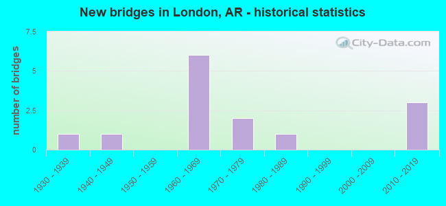
- New bridges - historical statistics
- 11930-1939
- 11940-1949
- 61960-1969
- 21970-1979
- 11980-1989
- 32010-2019
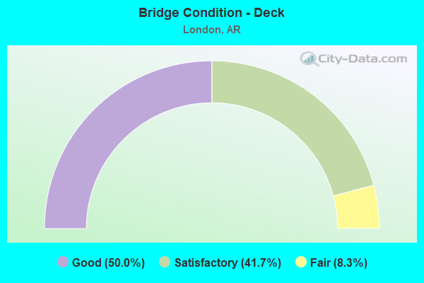
- Bridge Condition - Deck
- 50.0%Good
- 41.7%Satisfactory
- 8.3%Fair
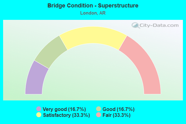
- Bridge Condition - Superstructure
- 16.7%Very good
- 16.7%Good
- 33.3%Satisfactory
- 33.3%Fair
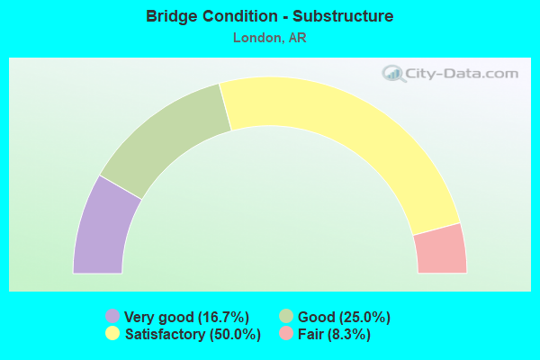
- Bridge Condition - Substructure
- 16.7%Very good
- 25.0%Good
- 50.0%Satisfactory
- 8.3%Fair
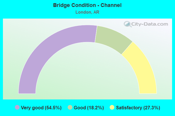
- Bridge Condition - Channel
- 54.5%Very good
- 18.2%Good
- 27.3%Satisfactory
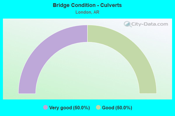
- Bridge Condition - Culverts
- 50.0%Very good
- 50.0%Good
Find on map >> Show street view
Structure Number: 3315, Location: 1.25 M E Johnson Co Line (Lat: 35.335369, Lng: -93.274669), Route carried "on" structure: County highway 78, Year Built: 1964, Status: Open, Structure Length: 10.00m (32.81ft), Average Daily Traffic: 254 (year 1987), Truck Traffic: 1%, Average Future Daily Traffic: 64 (year 2007), Design Load: H 15, Features Intersected: I 40-SEC 22, Facility Carried by Structure: George Town Rd
Minimum Vertical Clearance: 30+ m (98+ ft), Kilometerpoint: 0.467, Lanes on structure: 2, Lanes under structure: 4, Owner: State Highway Agency, Approaching Roadway Width: 8.2m (26.9ft), Material/Design: Steel, Design/Construction: Stringer/Multi-beam, Number Of Spans In Main Unit: 6, Length of Maximum Span: 17.7m (58.1ft), Curb or Sidewalk Widths: Left: 0.3m (1.0ft), Right: 0.3m (1.0ft), Curb-To-Curb Width: 7.3m (24.0ft), Out-to-Out Width: 8.6m (28.2ft)
Condition: Deck: Good, Superstructure: Good, Substructure: Good, Operating Rating: 53.5 metric tons, Method Used To Determine Operating Rating: Load Factor (LF), Inventory Rating: 31.8 metric tons, Method Used To Determine Inventory Rating: Load Factor (LF), Structural Evaluation: Better than present minimum criteria, Deck Geometry: Somewhat better than minimum adequacy, Underclear: High priority of corrective action, Approach Roadway Alignment: Equal to present minimum criteria, Designated Inspection Frequency: Every 24 months, Critical Feature Inspection Frequency: Every 24 months, Inspection Date: January 2022, Deck Structure Type: Concrete Cast-file-Place, Wearing Surface/Protective System: Wearing Surface: Monolithic Concrete
Find on map >> Show street view
Structure Number: 3542, Location: 0.26 MI W OF YELL CO LINE (Lat: 35.279261, Lng: -93.283631), Route carried "on" structure: State highway 22, Year Built: 1963, Status: Open, Structure Length: 6.40m (21.00ft), Average Daily Traffic: 3,375 (year 2018), Truck Traffic: 1%, Average Future Daily Traffic: 4,295 (year 2028), Design Load: HS 20, Features Intersected: Delaware Creek
Minimum Vertical Clearance: 30+ m (98+ ft), Kilometerpoint: 22.880, Lanes on structure: 2, Base Highway Network: Yes, Owner: State Highway Agency, Approaching Roadway Width: 12.2m (40.0ft), Material/Design: Concrete, Design/Construction: Slab, Number Of Spans In Main Unit: 7, Length of Maximum Span: 9.1m (29.9ft), Curb or Sidewalk Widths: Left: 0.5m (1.6ft), Right: 0.5m (1.6ft), Curb-To-Curb Width: 8.5m (27.9ft), Out-to-Out Width: 10.2m (33.5ft)
Condition: Deck: Satisfactory, Superstructure: Satisfactory, Substructure: Fair, Channel: Satisfactory, Operating Rating: 54.4 metric tons, Method Used To Determine Operating Rating: Load Factor (LF), Inventory Rating: 32.7 metric tons, Method Used To Determine Inventory Rating: Load Factor (LF), Structural Evaluation: Somewhat better than minimum adequacy, Deck Geometry: Meets minimum limits, Waterway Adequacy: Equal to present desirable criteria, Approach Roadway Alignment: Equal to present desirable criteria, Designated Inspection Frequency: Every 24 months, Critical Feature Inspection Frequency: Every 24 months, Underwater Inspection Frequency: Every 60 months, Inspection Date: May 2020, Underwater Inspection Date: November 2021, Deck Structure Type: Concrete Cast-file-Place, Wearing Surface/Protective System: Wearing Surface: Monolithic Concrete
Find on map >> Show street view
Structure Number: 3643, Location: 6.59 M E Johnson Co. line (Lat: 35.317939, Lng: -93.185239), Route carried "on" structure: US 64, Year Built: 1964, Status: Open, Structure Length: 17.10m (56.10ft), Average Daily Traffic: 9,777 (year 2018), Truck Traffic: 1%, Average Future Daily Traffic: 11,878 (year 2028), Design Load: HS 20, Features Intersected: Illinios Bayou
Minimum Vertical Clearance: 30+ m (98+ ft), Kilometerpoint: 10.602, Lanes on structure: 2, Owner: State Highway Agency, Approaching Roadway Width: 9.4m (30.8ft), Material/Design: Steel continuous, Design/Construction: Stringer/Multi-beam, Number Of Spans In Main Unit: 8, Length of Maximum Span: 23.5m (77.1ft), Curb-To-Curb Width: 8.5m (27.9ft), Out-to-Out Width: 10.1m (33.1ft)
Condition: Deck: Fair, Superstructure: Fair, Substructure: Satisfactory, Channel: Satisfactory, Operating Rating: 46.3 metric tons, Method Used To Determine Operating Rating: Load Factor (LF), Inventory Rating: 28.1 metric tons, Method Used To Determine Inventory Rating: Load Factor (LF), Structural Evaluation: Somewhat better than minimum adequacy, Deck Geometry: Meets minimum limits, Waterway Adequacy: Equal to present desirable criteria, Approach Roadway Alignment: Equal to present minimum criteria, Designated Inspection Frequency: Every 24 months, Critical Feature Inspection Frequency: Every 24 months, Underwater Inspection Frequency: Every 60 months, Inspection Date: August 2020, Underwater Inspection Date: November 2021, Deck Structure Type: Concrete Cast-file-Place, Wearing Surface/Protective System: Wearing Surface: Monolithic Concrete
Find on map >> Show street view
Structure Number: 16246, Location: 0.40 M S CO RD 5 & SH 333 (Lat: 35.309194, Lng: -93.223333), Route carried "on" structure: County highway 5, Year Built: 1971, Status: Open, Structure Length: 4.82m (15.81ft), Average Daily Traffic: 980 (year 2018), Truck Traffic: 1%, Average Future Daily Traffic: 137 (year 2007), Design Load: HS 20, Features Intersected: Dardanelle Lake, Facility Carried by Structure: May Rd - A
Minimum Vertical Clearance: 30+ m (98+ ft), Kilometerpoint: 0.644, Lanes on structure: 2, Owner: County Highway Agency, Approaching Roadway Width: 6.1m (20.0ft), Material/Design: Concrete, Design/Construction: Channel Beam, Number Of Spans In Main Unit: 5, Length of Maximum Span: 9.4m (30.8ft), Curb or Sidewalk Widths: Left: 0.3m (1.0ft), Right: 0.3m (1.0ft), Curb-To-Curb Width: 7.9m (25.9ft), Out-to-Out Width: 8.5m (27.9ft)
Condition: Deck: Satisfactory, Superstructure: Satisfactory, Substructure: Satisfactory, Channel: Satisfactory, Operating Rating: 31.8 metric tons, Method Used To Determine Operating Rating: Load Factor (LF), Inventory Rating: 19.1 metric tons, Method Used To Determine Inventory Rating: Load Factor (LF), Structural Evaluation: Somewhat better than minimum adequacy, Deck Geometry: Somewhat better than minimum adequacy, Waterway Adequacy: Equal to present desirable criteria, Approach Roadway Alignment: Equal to present desirable criteria, Designated Inspection Frequency: Every 24 months, Critical Feature Inspection Frequency: Every 24 months, Inspection Date: May 2021, Deck Structure Type: Concrete Precast Panels, Wearing Surface/Protective System: Wearing Surface: Monolithic Concrete
Find on map >> Show street view
Structure Number: 20466, Location: .45 MI N SH 64 (Lat: 35.329519, Lng: -93.203969), Route carried "on" structure: County highway 6, Year Built: 1983, Status: Open, Structure Length: 2.38m (7.81ft), Average Daily Traffic: 1,975 (year 2018), Truck Traffic: 1%, Average Future Daily Traffic: 1,390 (year 2007), Features Intersected: Mill Cr Lake Dardanelle, Facility Carried by Structure: Mill Creek Rd. - E
Minimum Vertical Clearance: 30+ m (98+ ft), Kilometerpoint: 13.242, Lanes on structure: 2, Owner: County Highway Agency, Approaching Roadway Width: 7.3m (24.0ft), Material/Design: Concrete, Design/Construction: Channel Beam, Number Of Spans In Main Unit: 4, Length of Maximum Span: 5.8m (19.0ft), Curb-To-Curb Width: 6.3m (20.7ft), Out-to-Out Width: 6.6m (21.7ft)
Condition: Deck: Good, Superstructure: Good, Substructure: Satisfactory, Channel: Good, Operating Rating: 35.4 metric tons, Method Used To Determine Operating Rating: Load Factor (LF), Inventory Rating: 21.8 metric tons, Method Used To Determine Inventory Rating: Load Factor (LF), Structural Evaluation: Somewhat better than minimum adequacy, Deck Geometry: High priority of replacement, Waterway Adequacy: Equal to present desirable criteria, Approach Roadway Alignment: High priority of corrective action, Length Of Structure Improvement: 3.17m (10.40ft), Designated Inspection Frequency: Every 24 months, Critical Feature Inspection Frequency: Every 24 months, Inspection Date: April 2021, Roadway Improvement Cost: $117,000, Total Project Cost: $308,000, Deck Structure Type: Concrete Precast Panels, Wearing Surface/Protective System: Wearing Surface: Bituminous
Find on map >> Show street view
Structure Number: 23979, Location: 1.3 MI E JCT SH 333 (Lat: 35.367308, Lng: -93.234769), Route carried "on" structure: County highway 6, Year Built: 2018, Status: Open, Structure Length: 1.19m (3.90ft), Average Daily Traffic: 273 (year 2018), Truck Traffic: 1%, Average Future Daily Traffic: 350 (year 2038), Features Intersected: Sulphur Creek, Facility Carried by Structure: Mill Creek Rd - E
Minimum Vertical Clearance: 30.44m (99.87ft), Kilometerpoint: 7.500, Lanes on structure: 2, Owner: County Highway Agency, Approaching Roadway Width: 7.0m (23.0ft), Material/Design: Concrete, Design/Construction: Culvert, Number Of Spans In Main Unit: 4, Length of Maximum Span: 2.4m (7.9ft), Curb-To-Curb Width: 10.1m (33.1ft), Out-to-Out Width: 11.6m (38.1ft)
Condition: Channel: Very good, Culverts: Very good, Operating Rating: 32.7 metric tons, Method Used To Determine Operating Rating: Load and Resistance Factor (LRFR), Inventory Rating: 25.4 metric tons, Method Used To Determine Inventory Rating: Load and Resistance Factor (LRFR), Structural Evaluation: Equal to present minimum criteria, Deck Geometry: Better than present minimum criteria, Waterway Adequacy: Better than present minimum criteria, Approach Roadway Alignment: Equal to present minimum criteria, Designated Inspection Frequency: Every 24 months, Critical Feature Inspection Frequency: Every 24 months, Inspection Date: May 2020
Find on map >> Show street view
Structure Number: A0402, Location: 0.26 MI E OF LOGAN CO (Lat: 35.277589, Lng: -93.274319), Route carried "on" structure: State highway 22, Year Built: 1962, Status: Open, Structure Length: 3.17m (10.40ft), Average Daily Traffic: 4,261 (year 2018), Truck Traffic: 1%, Average Future Daily Traffic: 3,848 (year 2028), Design Load: H 20, Features Intersected: Stinnet Creek
Minimum Vertical Clearance: 30+ m (98+ ft), Kilometerpoint: 0.418, Lanes on structure: 2, Base Highway Network: Yes, Owner: State Highway Agency, Approaching Roadway Width: 9.4m (30.8ft), Material/Design: Concrete, Design/Construction: Tee Beam, Number Of Spans In Main Unit: 3, Length of Maximum Span: 10.4m (34.1ft), Curb-To-Curb Width: 8.5m (27.9ft), Out-to-Out Width: 9.9m (32.5ft)
Condition: Deck: Satisfactory, Superstructure: Satisfactory, Substructure: Satisfactory, Channel: Very good, Operating Rating: 54.4 metric tons, Method Used To Determine Operating Rating: Load Factor (LF), Inventory Rating: 32.7 metric tons, Method Used To Determine Inventory Rating: Load Factor (LF), Structural Evaluation: Equal to present minimum criteria, Deck Geometry: Meets minimum limits, Waterway Adequacy: Equal to present desirable criteria, Approach Roadway Alignment: Equal to present desirable criteria, Length Of Structure Improvement: 3.17m (10.40ft), Designated Inspection Frequency: Every 24 months, Critical Feature Inspection Frequency: Every 24 months, Underwater Inspection Frequency: Every 60 months, Inspection Date: June 2020, Underwater Inspection Date: November 2021, Total Project Cost: $151,000, Deck Structure Type: Concrete Cast-file-Place, Wearing Surface/Protective System: Wearing Surface: Bituminous
Find on map >> Show street view
Structure Number: A3316, Location: 25 M E Johnson Co Line (Lat: 35.336761, Lng: -93.255561), Route carried "on" structure: Interstate 40, Year Built: 1964, Status: Open, Structure Length: 3.99m (13.09ft), Average Daily Traffic: 14,305 (year 2016), Truck Traffic: 1%, Average Future Daily Traffic: 14,688 (year 2028), Design Load: HS 20+Mod, Features Intersected: SH 333-SEC 1
Minimum Vertical Clearance: 30+ m (98+ ft), Kilometerpoint: 119.043, Lanes on structure: 2, Lanes under structure: 2, Base Highway Network: Yes, Owner: State Highway Agency, Approaching Roadway Width: 12.8m (42.0ft), Material/Design: Steel, Design/Construction: Stringer/Multi-beam, Number Of Spans In Main Unit: 3, Length of Maximum Span: 13.1m (43.0ft), Curb-To-Curb Width: 12.2m (40.0ft), Out-to-Out Width: 13.8m (45.3ft)
Condition: Deck: Good, Superstructure: Fair, Substructure: Good, Operating Rating: 54.4 metric tons, Method Used To Determine Operating Rating: Load Factor (LF), Inventory Rating: 32.7 metric tons, Method Used To Determine Inventory Rating: Load Factor (LF), Structural Evaluation: Somewhat better than minimum adequacy, Deck Geometry: Better than present minimum criteria, Underclear: Somewhat better than minimum adequacy, Approach Roadway Alignment: Equal to present desirable criteria, Designated Inspection Frequency: Every 24 months, Critical Feature Inspection Frequency: Every 24 months, Inspection Date: January 2022, Deck Structure Type: Concrete Cast-file-Place, Wearing Surface/Protective System: Wearing Surface: Latex Concrete
Find on map >> Show street view
Structure Number: A6916, Location: 2.7 MI E Jct SH 333 (Lat: 35.324531, Lng: -93.206939), Route carried "on" structure: Interstate 40, Year Built: 2013, Status: Open, Structure Length: 11.46m (37.60ft), Average Daily Traffic: 13,500 (year 2018), Truck Traffic: 33%, Average Future Daily Traffic: 19,950 (year 2033), Design Load: HS 20+Mod, Features Intersected: Co Rd 611, 6 & Mill Cr
Minimum Vertical Clearance: 30.44m (99.87ft), Kilometerpoint: 123.678, Lanes on structure: 2, Lanes under structure: 4, Base Highway Network: Yes, Owner: State Highway Agency, Approaching Roadway Width: 11.6m (38.1ft), Material/Design: Steel continuous, Design/Construction: Stringer/Multi-beam, Number Of Spans In Main Unit: 3, Length of Maximum Span: 48.8m (160.1ft), Curb-To-Curb Width: 12.2m (40.0ft), Out-to-Out Width: 13.2m (43.3ft)
Condition: Deck: Satisfactory, Superstructure: Very good, Substructure: Very good, Channel: Very good, Operating Rating: 54.4 metric tons, Method Used To Determine Operating Rating: Load Factor (LF), Inventory Rating: 32.7 metric tons, Method Used To Determine Inventory Rating: Load Factor (LF), Structural Evaluation: Equal to present desirable criteria, Deck Geometry: Better than present minimum criteria, Underclear: Meets minimum limits, Waterway Adequacy: Superior to present desirable criteria, Approach Roadway Alignment: Equal to present desirable criteria, Designated Inspection Frequency: Every 24 months, Critical Feature Inspection Frequency: Every 24 months, Inspection Date: June 2021, Deck Structure Type: Concrete Cast-file-Place, Wearing Surface/Protective System: Wearing Surface: Monolithic Concrete, Deck Protection: Epoxy Coated Reinforcing
Find on map >> Show street view
Structure Number: B3316, Location: 0.1 M N Jct US 64 (Lat: 35.336239, Lng: -93.255431), Route carried "on" structure: Interstate 40, Year Built: 1964, Status: Open, Structure Length: 3.99m (13.09ft), Average Daily Traffic: 14,305 (year 2016), Truck Traffic: 1%, Average Future Daily Traffic: 14,688 (year 2028), Design Load: HS 20+Mod, Features Intersected: SH 333-SEC 1
Minimum Vertical Clearance: 30+ m (98+ ft), Kilometerpoint: 119.043, Lanes on structure: 2, Lanes under structure: 2, Base Highway Network: Yes, Owner: State Highway Agency, Approaching Roadway Width: 12.8m (42.0ft), Material/Design: Steel, Design/Construction: Stringer/Multi-beam, Number Of Spans In Main Unit: 3, Length of Maximum Span: 13.1m (43.0ft), Curb-To-Curb Width: 12.2m (40.0ft), Out-to-Out Width: 13.7m (44.9ft)
Condition: Deck: Good, Superstructure: Fair, Substructure: Good, Operating Rating: 54.4 metric tons, Method Used To Determine Operating Rating: Load Factor (LF), Inventory Rating: 32.7 metric tons, Method Used To Determine Inventory Rating: Load Factor (LF), Structural Evaluation: Somewhat better than minimum adequacy, Deck Geometry: Better than present minimum criteria, Underclear: Somewhat better than minimum adequacy, Approach Roadway Alignment: Equal to present desirable criteria, Designated Inspection Frequency: Every 24 months, Critical Feature Inspection Frequency: Every 24 months, Inspection Date: January 2022, Deck Structure Type: Concrete Cast-file-Place, Wearing Surface/Protective System: Wearing Surface: Latex Concrete
Find on map >> Show street view
Structure Number: B6916, Location: 2.7 MI E Jct SH 333 (Lat: 35.324289, Lng: -93.206989), Route carried "on" structure: Interstate 40, Year Built: 2013, Status: Open, Structure Length: 11.46m (37.60ft), Average Daily Traffic: 13,500 (year 2018), Truck Traffic: 28%, Average Future Daily Traffic: 14,688 (year 2028), Design Load: HS 20+Mod, Features Intersected: Co Rd 611, 6 & Mill Cr
Minimum Vertical Clearance: 30.44m (99.87ft), Kilometerpoint: 123.678, Lanes on structure: 2, Lanes under structure: 4, Base Highway Network: Yes, Owner: State Highway Agency, Approaching Roadway Width: 11.6m (38.1ft), Material/Design: Steel continuous, Design/Construction: Stringer/Multi-beam, Number Of Spans In Main Unit: 3, Length of Maximum Span: 48.8m (160.1ft), Curb-To-Curb Width: 12.2m (40.0ft), Out-to-Out Width: 13.2m (43.3ft)
Condition: Deck: Good, Superstructure: Very good, Substructure: Very good, Channel: Very good, Operating Rating: 54.4 metric tons, Method Used To Determine Operating Rating: Load Factor (LF), Inventory Rating: 32.7 metric tons, Method Used To Determine Inventory Rating: Load Factor (LF), Structural Evaluation: Equal to present desirable criteria, Deck Geometry: Better than present minimum criteria, Underclear: High priority of corrective action, Waterway Adequacy: Superior to present desirable criteria, Approach Roadway Alignment: Equal to present desirable criteria, Designated Inspection Frequency: Every 24 months, Critical Feature Inspection Frequency: Every 24 months, Inspection Date: June 2021, Deck Structure Type: Concrete Cast-file-Place, Wearing Surface/Protective System: Wearing Surface: Monolithic Concrete, Deck Protection: Epoxy Coated Reinforcing
Find on map >> Show street view
Structure Number: M0537, Location: 1.24 MI EAST OF LOGAN CO (Lat: 35.275639, Lng: -93.257358), Route carried "on" structure: State highway 22, Year Built: 1930, Year Reconstructed: 1962, Status: Open, Structure Length: 0.67m (2.20ft), Average Daily Traffic: 4,261 (year 2018), Truck Traffic: 1%, Average Future Daily Traffic: 3,848 (year 2028), Design Load: H 20, Features Intersected: Ditch
Minimum Vertical Clearance: 30+ m (98+ ft), Kilometerpoint: 1.996, Lanes on structure: 2, Base Highway Network: Yes, Owner: State Highway Agency, Approaching Roadway Width: 12.2m (40.0ft), Material/Design: Concrete, Design/Construction: Culvert, Number Of Spans In Main Unit: 2, Length of Maximum Span: 3.4m (11.2ft)
Condition: Channel: Very good, Culverts: Good, Operating Rating: 41.7 metric tons, Method Used To Determine Operating Rating: Load Factor (LF), Inventory Rating: 25.4 metric tons, Method Used To Determine Inventory Rating: Load Factor (LF), Structural Evaluation: Equal to present minimum criteria, Waterway Adequacy: Equal to present desirable criteria, Approach Roadway Alignment: Equal to present desirable criteria, Designated Inspection Frequency: Every 48 months, Critical Feature Inspection Frequency: Every 24 months, Inspection Date: June 2018
Find on map >> Show street view
Structure Number: M3255, Location: 0.47 M S Jct. US 64 (Lat: 35.318269, Lng: -93.214228), Route carried "on" structure: State highway 333, Year Built: 1970, Status: Open, Structure Length: 2.10m (6.89ft), Average Daily Traffic: 3,721 (year 2018), Truck Traffic: 2%, Average Future Daily Traffic: 3,065 (year 2028), Design Load: H 15, Features Intersected: Lake Dardanelle
Minimum Vertical Clearance: 30+ m (98+ ft), Kilometerpoint: 0.756, Lanes on structure: 2, Owner: State Highway Agency, Approaching Roadway Width: 8.2m (26.9ft), Material/Design: Concrete, Design/Construction: Channel Beam, Number Of Spans In Main Unit: 3, Length of Maximum Span: 9.4m (30.8ft), Curb-To-Curb Width: 7.9m (25.9ft), Out-to-Out Width: 8.6m (28.2ft)
Condition: Deck: Good, Superstructure: Fair, Substructure: Satisfactory, Channel: Very good, Operating Rating: 33.6 metric tons, Method Used To Determine Operating Rating: Load Factor (LF), Inventory Rating: 20.0 metric tons, Method Used To Determine Inventory Rating: Load Factor (LF), Structural Evaluation: Somewhat better than minimum adequacy, Deck Geometry: High priority of corrective action, Waterway Adequacy: Equal to present desirable criteria, Approach Roadway Alignment: Better than present minimum criteria, Length Of Structure Improvement: 2.87m (9.42ft), Designated Inspection Frequency: Every 24 months, Critical Feature Inspection Frequency: Every 24 months, Inspection Date: August 2020, Roadway Improvement Cost: $125,000, Total Project Cost: $313,000, Deck Structure Type: Concrete Precast Panels, Wearing Surface/Protective System: Wearing Surface: Bituminous
Find on map >> Show street view
Structure Number: M3821, Location: 0.7 MI S US 64 (Lat: 35.324311, Lng: -93.251819), Route carried "on" structure: State highway 333, Year Built: 1941, Status: Posted for load, Structure Length: 0.88m (2.89ft), Average Daily Traffic: 950 (year 2018), Truck Traffic: 2%, Average Future Daily Traffic: 690 (year 2028), Design Load: H 10, Features Intersected: Creek
Minimum Vertical Clearance: 30+ m (98+ ft), Kilometerpoint: 5.053, Lanes on structure: 2, Owner: State Highway Agency, Approaching Roadway Width: 8.5m (27.9ft), Material/Design: Concrete, Design/Construction: Slab, Number Of Spans In Main Unit: 2, Length of Maximum Span: 4.3m (14.1ft), Curb or Sidewalk Widths: Left: 0.2m (0.7ft), Right: 0.2m (0.7ft), Curb-To-Curb Width: 8.6m (28.2ft), Out-to-Out Width: 9.0m (29.5ft)
Condition: Deck: Satisfactory, Superstructure: Satisfactory, Substructure: Satisfactory, Channel: Good, Operating Rating: 25.4 metric tons, Method Used To Determine Operating Rating: Load Factor (LF), Inventory Rating: 15.4 metric tons, Method Used To Determine Inventory Rating: Load Factor (LF), Structural Evaluation: Meets minimum limits, Deck Geometry: Somewhat better than minimum adequacy, Waterway Adequacy: Better than present minimum criteria, Approach Roadway Alignment: Equal to present desirable criteria, Bridge Posting: Required (Relationship of Operating Rating to Maximum Legal Load: 10.0 - 19.9% below), Designated Inspection Frequency: Every 24 months, Critical Feature Inspection Frequency: Every 24 months, Inspection Date: August 2021, Deck Structure Type: Concrete Cast-file-Place, Wearing Surface/Protective System: Wearing Surface: Bituminous
Find on map >> Show street view
Structure Number: 3315, Location: 1.25 M E Johnson Co Line (Lat: 35.335369, Lng: -93.274669), Route carried "under" structure: Interstate 40, Structure Length: 0. m, Average Daily Traffic: 12,000 (year 2013), Truck Traffic: 1%, Features Intersected: I 40-SEC 22, Facility Carried by Structure: George Town Rd
Minimum Vertical Clearance: 5.18m (16.99ft), Kilometerpoint: 117.289, Length of Maximum Span: 0.0m
Find on map >> Show street view
Structure Number: 3315, Location: 1.25 M E Johnson Co Line (Lat: 35.335369, Lng: -93.274669), Route carried "under" structure: Interstate 40, Structure Length: 0. m, Average Daily Traffic: 12,000 (year 2013), Truck Traffic: 1%, Features Intersected: I 40-SEC 22, Facility Carried by Structure: George Town Rd
Minimum Vertical Clearance: 5.12m (16.80ft), Kilometerpoint: 117.289, Length of Maximum Span: 0.0m
Find on map >> Show street view
Structure Number: A3316, Location: 25 M E Johnson Co Line (Lat: 35.336761, Lng: -93.255561), Route carried "under" structure: State highway 333, Structure Length: 0. m, Average Daily Traffic: 1,200 (year 2014), Truck Traffic: 1%, Features Intersected: SH 333-SEC 1, Facility Carried by Structure: I 40-SEC 22, WB LN
Minimum Vertical Clearance: 4.92m (16.14ft), Kilometerpoint: 0.660, Length of Maximum Span: 0.0m
Find on map >> Show street view
Structure Number: A6916, Location: 2.7 MI E Jct SH 333 (Lat: 35.324531, Lng: -93.206939), Route carried "under" structure: County highway 6, Structure Length: 0. m, Features Intersected: I-40, Facility Carried by Structure: I40, Sec 22, WB Ln
Minimum Vertical Clearance: 7.64m (25.07ft), Kilometerpoint: 0.113, Length of Maximum Span: 0.0m
Find on map >> Show street view
Structure Number: A6916, Location: 2.7 MI E Jct SH 333 (Lat: 35.324531, Lng: -93.206939), Route carried "under" structure: County highway 611, Structure Length: 0. m, Features Intersected: I-40, Facility Carried by Structure: I40, Sec 22, WB Ln
Minimum Vertical Clearance: 5.69m (18.67ft), Kilometerpoint: 0.113, Length of Maximum Span: 0.0m
Find on map >> Show street view
Structure Number: B3316, Location: 0.1 M N Jct US 64 (Lat: 35.336239, Lng: -93.255431), Route carried "under" structure: State highway 333, Structure Length: 0. m, Average Daily Traffic: 1,700 (year 2014), Truck Traffic: 1%, Features Intersected: SH 333-SEC 1, Facility Carried by Structure: I 40-SEC 22, EB LN
Minimum Vertical Clearance: 4.77m (15.65ft), Kilometerpoint: 0.612, Length of Maximum Span: 0.0m
Find on map >> Show street view
Structure Number: B6916, Location: 2.7 MI E Jct SH 333 (Lat: 35.324289, Lng: -93.206989), Route carried "under" structure: County highway 611, Structure Length: 0. m, Features Intersected: I-40, Facility Carried by Structure: I40, Sec 22, EB Ln
Minimum Vertical Clearance: 7.03m (23.06ft), Kilometerpoint: 0.097, Length of Maximum Span: 0.0m
Find on map >> Show street view
Structure Number: B6916, Location: 2.7 MI E Jct SH 333 (Lat: 35.324289, Lng: -93.206989), Route carried "under" structure: County highway 6, Structure Length: 0. m, Features Intersected: I-40, Facility Carried by Structure: I40, Sec 22, EB Ln
Minimum Vertical Clearance: 7.56m (24.80ft), Kilometerpoint: 0.097, Length of Maximum Span: 0.0m