Bridge Statistics for Longville, Louisiana (LA)
Condition, Traffic, Stress, Structural Evaluation, Project Costs
- National Bridge Inventory (NBI) Statistics
- 12Number of bridges
- 92ft / 27.6mTotal length
- 43,585Total average daily traffic
- 6,773Total average daily truck traffic
- 37,934Total future (year 2036) average daily traffic
- National Bridge Inventory (NBI) Registered Bridges for Longville
- No street view available for this location
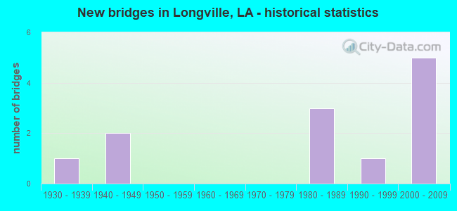
- New bridges - historical statistics
- 11930-1939
- 21940-1949
- 31980-1989
- 11990-1999
- 52000-2009


- Bridge Condition - Deck
- 57.1%Satisfactory
- 42.9%Fair

- Bridge Condition - Superstructure
- 28.6%Good
- 28.6%Satisfactory
- 42.9%Fair

- Bridge Condition - Substructure
- 28.6%Good
- 42.9%Satisfactory
- 28.6%Fair

- Bridge Condition - Channel
- 33.3%Good
- 50.0%Satisfactory
- 16.7%Fair

- Bridge Condition - Culverts
- 20.0%Good
- 80.0%Satisfactory
Find on map >> Show street view
Structure Number: 70600240310521, Location: 3.1 MI NORTH OF US 190 (Lat: 30.554861, Lng: -93.232339), Route carried "on" structure: US 171, Year Built: 1932, Status: Open, Structure Length: 1.07m (3.51ft), Average Daily Traffic: 10,300 (year 2016), Truck Traffic: 16%, Average Future Daily Traffic: 6,000 (year 2036), Design Load: H 15, Features Intersected: CREEK
Minimum Vertical Clearance: 30+ m (98+ ft), Kilometerpoint: 16.916, Lanes on structure: 2, Base Highway Network: Yes (Inventory Route: 24-03-1, Subroute: 10), Owner: State Highway Agency, Approaching Roadway Width: 13.7m (44.9ft), Material/Design: Concrete, Design/Construction: Culvert, Number Of Spans In Main Unit: 5, Length of Maximum Span: 1.8m (5.9ft), Curb-To-Curb Width: 28.1m (92.2ft), Out-to-Out Width: 46.9m (153.9ft)
Condition: Channel: Satisfactory, Culverts: Good, Operating Rating: 42.1 metric tons, Method Used To Determine Operating Rating: Load and Resistance Factor Rating (LRFR) rating reported by rating factor(RF) method using HL-93 loadings, Inventory Rating: 32.4 metric tons, Method Used To Determine Inventory Rating: Load and Resistance Factor Rating (LRFR) rating reported by rating factor(RF) method using HL-93 loadings, Structural Evaluation: Better than present minimum criteria, Deck Geometry: Superior to present desirable criteria, Waterway Adequacy: Equal to present minimum criteria, Approach Roadway Alignment: Equal to present desirable criteria, Designated Inspection Frequency: Every 24 months, Inspection Date: September 2020, Deck Structure Type: Concrete Cast-file-Place
Find on map >> Show street view
Structure Number: 70600240401581, Location: 1.6 MI N OF LA 110 (Lat: 30.628261, Lng: -93.232400), Route carried "on" structure: US 171, Year Built: 2007, Status: Open, Structure Length: 1.01m (3.31ft), Average Daily Traffic: 7,300 (year 2016), Truck Traffic: 16%, Average Future Daily Traffic: 4,200 (year 2036), Design Load: H 15, Features Intersected: CREEK
Minimum Vertical Clearance: 30+ m (98+ ft), Kilometerpoint: 2.530, Lanes on structure: 2, Base Highway Network: Yes (Inventory Route: 24-04-1, Subroute: 10), Owner: State Highway Agency, Approaching Roadway Width: 14.0m (45.9ft), Skew: 30 degrees, Material/Design: Concrete, Design/Construction: Culvert, Number Of Spans In Main Unit: 5, Length of Maximum Span: 1.8m (5.9ft)
Condition: Channel: Satisfactory, Culverts: Satisfactory, Operating Rating: 42.1 metric tons, Method Used To Determine Operating Rating: Load and Resistance Factor Rating (LRFR) rating reported by rating factor(RF) method using HL-93 loadings, Inventory Rating: 32.4 metric tons, Method Used To Determine Inventory Rating: Load and Resistance Factor Rating (LRFR) rating reported by rating factor(RF) method using HL-93 loadings, Structural Evaluation: Equal to present minimum criteria, Waterway Adequacy: Equal to present desirable criteria, Approach Roadway Alignment: Equal to present desirable criteria, Designated Inspection Frequency: Every 24 months, Inspection Date: September 2021, Deck Structure Type: Concrete Cast-file-Place
Find on map >> Show street view
Structure Number: 70600240402091, Location: 2.1 MI N OF LA 110 (Lat: 30.635569, Lng: -93.232400), Route carried "on" structure: US 171, Year Built: 2007, Status: Open, Structure Length: 0.88m (2.89ft), Average Daily Traffic: 7,300 (year 2016), Truck Traffic: 16%, Average Future Daily Traffic: 8,030 (year 2036), Design Load: HS 20, Features Intersected: CREEK
Minimum Vertical Clearance: 30+ m (98+ ft), Kilometerpoint: 3.341, Lanes on structure: 2, Base Highway Network: Yes (Inventory Route: 24-04-1, Subroute: 10), Owner: State Highway Agency, Approaching Roadway Width: 7.3m (24.0ft), Skew: 30 degrees, Material/Design: Concrete, Design/Construction: Culvert, Number Of Spans In Main Unit: 5, Length of Maximum Span: 1.5m (4.9ft)
Condition: Channel: Good, Culverts: Satisfactory, Operating Rating: 42.1 metric tons, Method Used To Determine Operating Rating: Load and Resistance Factor Rating (LRFR) rating reported by rating factor(RF) method using HL-93 loadings, Inventory Rating: 32.4 metric tons, Method Used To Determine Inventory Rating: Load and Resistance Factor Rating (LRFR) rating reported by rating factor(RF) method using HL-93 loadings, Structural Evaluation: Equal to present minimum criteria, Waterway Adequacy: Equal to present desirable criteria, Approach Roadway Alignment: Equal to present desirable criteria, Designated Inspection Frequency: Every 24 months, Inspection Date: September 2021, Deck Structure Type: Concrete Cast-file-Place
Find on map >> Show street view
Structure Number: 70600240402961, Location: 2.9 MI NORTH OF LA 110 (Lat: 30.648139, Lng: -93.232500), Route carried "on" structure: US 171, Year Built: 2007, Status: Open, Structure Length: 0.82m (2.69ft), Average Daily Traffic: 7,300 (year 2016), Truck Traffic: 16%, Average Future Daily Traffic: 8,030 (year 2036), Design Load: H 15, Features Intersected: BARRENLIN BRANCH
Minimum Vertical Clearance: 30+ m (98+ ft), Kilometerpoint: 4.733, Lanes on structure: 2, Base Highway Network: Yes (Inventory Route: 24-04-1, Subroute: 10), Owner: State Highway Agency, Approaching Roadway Width: 12.5m (41.0ft), Skew: 30 degrees, Material/Design: Concrete, Design/Construction: Culvert, Number Of Spans In Main Unit: 3, Length of Maximum Span: 2.4m (7.9ft)
Condition: Channel: Fair, Culverts: Satisfactory, Operating Rating: 42.1 metric tons, Method Used To Determine Operating Rating: Load and Resistance Factor Rating (LRFR) rating reported by rating factor(RF) method using HL-93 loadings, Inventory Rating: 32.4 metric tons, Method Used To Determine Inventory Rating: Load and Resistance Factor Rating (LRFR) rating reported by rating factor(RF) method using HL-93 loadings, Structural Evaluation: Equal to present minimum criteria, Waterway Adequacy: Equal to present desirable criteria, Approach Roadway Alignment: Equal to present desirable criteria, Designated Inspection Frequency: Every 24 months, Inspection Date: September 2021, Deck Structure Type: Concrete Cast-file-Place
Find on map >> Show street view
Structure Number: 70600240404111, Location: 4.1 MI NORTH OF 110 (Lat: 30.664669, Lng: -93.232700), Route carried "on" structure: US 171, Year Built: 2007, Status: Open, Structure Length: 0.82m (2.69ft), Average Daily Traffic: 7,300 (year 2016), Truck Traffic: 16%, Average Future Daily Traffic: 8,030 (year 2036), Design Load: HS 20, Features Intersected: CREEK
Minimum Vertical Clearance: 30+ m (98+ ft), Kilometerpoint: 6.565, Lanes on structure: 2, Base Highway Network: Yes (Inventory Route: 24-04-1, Subroute: 10), Owner: State Highway Agency, Approaching Roadway Width: 7.3m (24.0ft), Skew: 36 degrees, Material/Design: Concrete, Design/Construction: Culvert, Number Of Spans In Main Unit: 3, Length of Maximum Span: 2.4m (7.9ft)
Condition: Channel: Satisfactory, Culverts: Satisfactory, Operating Rating: 42.1 metric tons, Method Used To Determine Operating Rating: Load and Resistance Factor Rating (LRFR) rating reported by rating factor(RF) method using HL-93 loadings, Inventory Rating: 32.4 metric tons, Method Used To Determine Inventory Rating: Load and Resistance Factor Rating (LRFR) rating reported by rating factor(RF) method using HL-93 loadings, Structural Evaluation: Equal to present minimum criteria, Waterway Adequacy: Equal to present desirable criteria, Approach Roadway Alignment: Equal to present desirable criteria, Designated Inspection Frequency: Every 24 months, Inspection Date: September 2021, Deck Structure Type: Concrete Cast-file-Place
Find on map >> Show street view
Structure Number: 70601900209661, Location: 9.66 MI. E OF INT LA27 (Lat: 30.606361, Lng: -93.297600), Route carried "on" structure: State highway 110, Year Built: 2003, Status: Open, Structure Length: 2.41m (7.91ft), Average Daily Traffic: 890 (year 2016), Truck Traffic: 17%, Average Future Daily Traffic: 528 (year 2036), Design Load: HS 20, Features Intersected: WILDCOW CREEK
Minimum Vertical Clearance: 30+ m (98+ ft), Kilometerpoint: 15.244, Lanes on structure: 2, Owner: State Highway Agency, Approaching Roadway Width: 9.4m (30.8ft), Material/Design: Concrete, Design/Construction: Slab, Number Of Spans In Main Unit: 4, Length of Maximum Span: 6.1m (20.0ft), Curb-To-Curb Width: 7.3m (24.0ft), Out-to-Out Width: 12.8m (42.0ft)
Condition: Deck: Satisfactory, Superstructure: Satisfactory, Substructure: Satisfactory, Channel: Good, Operating Rating: 44.1 metric tons, Method Used To Determine Operating Rating: Load and Resistance Factor Rating (LRFR) rating reported by rating factor(RF) method using HL-93 loadings, Inventory Rating: 34.0 metric tons, Method Used To Determine Inventory Rating: Load and Resistance Factor Rating (LRFR) rating reported by rating factor(RF) method using HL-93 loadings, Structural Evaluation: Equal to present minimum criteria, Deck Geometry: Meets minimum limits, Waterway Adequacy: Equal to present desirable criteria, Approach Roadway Alignment: Equal to present desirable criteria, Designated Inspection Frequency: Every 24 months, Inspection Date: March 2021, Deck Structure Type: Concrete Cast-file-Place
Find on map >> Show street view
Structure Number: 70601900211701, Location: 11.70 MI. E OF INT LA27 (Lat: 30.606461, Lng: -93.263900), Route carried "on" structure: State highway 110, Year Built: 1948, Status: Open, Structure Length: 4.88m (16.01ft), Average Daily Traffic: 890 (year 2016), Truck Traffic: 17%, Average Future Daily Traffic: 528 (year 2036), Design Load: H 15, Features Intersected: HICKORY BRANCH
Minimum Vertical Clearance: 30+ m (98+ ft), Kilometerpoint: 18.470, Lanes on structure: 2, Owner: State Highway Agency, Approaching Roadway Width: 10.4m (34.1ft), Material/Design: Concrete, Design/Construction: Tee Beam, Number Of Spans In Main Unit: 8, Length of Maximum Span: 6.1m (20.0ft), Curb-To-Curb Width: 7.3m (24.0ft), Out-to-Out Width: 8.8m (28.9ft)
Condition: Deck: Satisfactory, Superstructure: Good, Substructure: Good, Channel: Good, Operating Rating: 29.8 metric tons, Method Used To Determine Operating Rating: Load and Resistance Factor Rating (LRFR) rating reported by rating factor(RF) method using HL-93 loadings, Inventory Rating: 23.0 metric tons, Method Used To Determine Inventory Rating: Load and Resistance Factor Rating (LRFR) rating reported by rating factor(RF) method using HL-93 loadings, Structural Evaluation: Equal to present minimum criteria, Deck Geometry: Meets minimum limits, Waterway Adequacy: Better than present minimum criteria, Approach Roadway Alignment: Equal to present desirable criteria, Designated Inspection Frequency: Every 24 months, Inspection Date: August 2020, Deck Structure Type: Concrete Cast-file-Place
Find on map >> Show street view
Structure Number: 70601900211841, Location: 11.84 MI. E OF INT LA27 (Lat: 30.606481, Lng: -93.257900), Route carried "on" structure: State highway 110, Year Built: 1948, Status: Open, Structure Length: 1.83m (6.00ft), Average Daily Traffic: 890 (year 2016), Truck Traffic: 17%, Average Future Daily Traffic: 528 (year 2036), Design Load: H 15, Features Intersected: CREEK
Minimum Vertical Clearance: 30+ m (98+ ft), Kilometerpoint: 19.048, Lanes on structure: 2, Owner: State Highway Agency, Approaching Roadway Width: 10.4m (34.1ft), Material/Design: Concrete, Design/Construction: Tee Beam, Number Of Spans In Main Unit: 3, Length of Maximum Span: 6.1m (20.0ft), Curb-To-Curb Width: 7.3m (24.0ft), Out-to-Out Width: 8.8m (28.9ft)
Condition: Deck: Satisfactory, Superstructure: Good, Substructure: Good, Channel: Good, Operating Rating: 63.5 metric tons, Method Used To Determine Operating Rating: Load Factor (LF), Inventory Rating: 37.2 metric tons, Method Used To Determine Inventory Rating: Load Factor (LF), Structural Evaluation: Better than present minimum criteria, Deck Geometry: Meets minimum limits, Waterway Adequacy: Equal to present minimum criteria, Approach Roadway Alignment: Equal to present desirable criteria, Designated Inspection Frequency: Every 24 months, Inspection Date: August 2020, Deck Structure Type: Concrete Cast-file-Place
Find on map >> Show street view
Structure Number: 70630342931541, Location: 1.4 MI W of US 171 (Lat: 30.569650, Lng: -93.255700), Route carried "on" structure: County highway , Year Built: 1984, Status: Open, Structure Length: 5.21m (17.09ft), Average Daily Traffic: 610 (year 2020), Average Future Daily Traffic: 671 (year 2036), Design Load: HS 20, Features Intersected: HICKORY BRANCH, Facility Carried by Structure: LONGVILLE CHRCH RD
Minimum Vertical Clearance: 30+ m (98+ ft), Kilometerpoint: 0.000, Lanes on structure: 2, Owner: County Highway Agency, Approaching Roadway Width: 9.4m (30.8ft), Material/Design: Concrete, Design/Construction: Slab, Number Of Spans In Main Unit: 9, Length of Maximum Span: 5.8m (19.0ft), Curb-To-Curb Width: 6.4m (21.0ft), Out-to-Out Width: 9.4m (30.8ft)
Condition: Deck: Fair, Superstructure: Fair, Substructure: Satisfactory, Channel: Fair, Operating Rating: 48.6 metric tons, Method Used To Determine Operating Rating: Load and Resistance Factor Rating (LRFR) rating reported by rating factor(RF) method using HL-93 loadings, Inventory Rating: 37.6 metric tons, Method Used To Determine Inventory Rating: Load and Resistance Factor Rating (LRFR) rating reported by rating factor(RF) method using HL-93 loadings, Structural Evaluation: Somewhat better than minimum adequacy, Deck Geometry: High priority of corrective action, Waterway Adequacy: Equal to present desirable criteria, Approach Roadway Alignment: Better than present minimum criteria, Designated Inspection Frequency: Every 24 months, Inspection Date: January 2022, Deck Structure Type: Concrete Precast Panels
Find on map >> Show street view
Structure Number: 70630366931161, Location: 2.2 MI E. of US 171 (Lat: 30.607200, Lng: -93.196000), Route carried "on" structure: County highway , Year Built: 1983, Status: Open, Structure Length: 2.90m (9.51ft), Average Daily Traffic: 250 (year 2020), Average Future Daily Traffic: 600 (year 2036), Design Load: HS 20, Features Intersected: BARNES CREEK, Facility Carried by Structure: LONGVILLE RD
Minimum Vertical Clearance: 30+ m (98+ ft), Kilometerpoint: 0.000, Lanes on structure: 2, Owner: County Highway Agency, Approaching Roadway Width: 10.4m (34.1ft), Material/Design: Concrete, Design/Construction: Slab, Number Of Spans In Main Unit: 5, Length of Maximum Span: 5.8m (19.0ft), Curb-To-Curb Width: 7.3m (24.0ft), Out-to-Out Width: 8.7m (28.5ft)
Condition: Deck: Fair, Superstructure: Fair, Substructure: Fair, Channel: Satisfactory, Operating Rating: 33.0 metric tons, Method Used To Determine Operating Rating: Load and Resistance Factor Rating (LRFR) rating reported by rating factor(RF) method using HL-93 loadings, Inventory Rating: 25.3 metric tons, Method Used To Determine Inventory Rating: Load and Resistance Factor Rating (LRFR) rating reported by rating factor(RF) method using HL-93 loadings, Structural Evaluation: Somewhat better than minimum adequacy, Deck Geometry: Somewhat better than minimum adequacy, Waterway Adequacy: Better than present minimum criteria, Approach Roadway Alignment: Somewhat better than minimum adequacy, Designated Inspection Frequency: Every 24 months, Inspection Date: Febuary 2022, Deck Structure Type: Concrete Precast Panels
Find on map >> Show street view
Structure Number: 70630368931101, Location: 3.9 MI EAST OF US 190 (Lat: 30.613650, Lng: -93.181700), Route carried "on" structure: County highway , Year Built: 1986, Status: Open, Structure Length: 2.90m (9.51ft), Average Daily Traffic: 220 (year 2020), Average Future Daily Traffic: 420 (year 2036), Design Load: HS 20, Features Intersected: CANEY CREEK, Facility Carried by Structure: LONGVILLE RD
Minimum Vertical Clearance: 30+ m (98+ ft), Kilometerpoint: 0.000, Lanes on structure: 2, Owner: County Highway Agency, Approaching Roadway Width: 11.0m (36.1ft), Material/Design: Concrete, Design/Construction: Slab, Number Of Spans In Main Unit: 5, Length of Maximum Span: 5.8m (19.0ft), Curb-To-Curb Width: 9.8m (32.2ft), Out-to-Out Width: 10.7m (35.1ft)
Condition: Deck: Fair, Superstructure: Fair, Substructure: Fair, Channel: Satisfactory, Operating Rating: 49.6 metric tons, Method Used To Determine Operating Rating: Load and Resistance Factor Rating (LRFR) rating reported by rating factor(RF) method using HL-93 loadings, Inventory Rating: 38.2 metric tons, Method Used To Determine Inventory Rating: Load and Resistance Factor Rating (LRFR) rating reported by rating factor(RF) method using HL-93 loadings, Structural Evaluation: Somewhat better than minimum adequacy, Deck Geometry: Better than present minimum criteria, Waterway Adequacy: Equal to present desirable criteria, Approach Roadway Alignment: Better than present minimum criteria, Designated Inspection Frequency: Every 24 months, Inspection Date: Febuary 2022, Deck Structure Type: Concrete Precast Panels
Find on map >> Show street view
Structure Number: 70630390931321, Location: 0.6 MI E. of US 171 (Lat: 30.649969, Lng: -93.221919), Route carried "on" structure: County highway , Year Built: 1992, Status: Open, Structure Length: 2.90m (9.51ft), Average Daily Traffic: 335 (year 2020), Average Future Daily Traffic: 369 (year 2040), Design Load: HS 20, Features Intersected: BARNES CREEK, Facility Carried by Structure: MEMORIAL CHURCH RD
Minimum Vertical Clearance: 30+ m (98+ ft), Kilometerpoint: 0.000, Lanes on structure: 2, Owner: County Highway Agency, Approaching Roadway Width: 6.1m (20.0ft), Material/Design: Concrete, Design/Construction: Slab, Number Of Spans In Main Unit: 5, Length of Maximum Span: 5.8m (19.0ft), Curb-To-Curb Width: 7.3m (24.0ft), Out-to-Out Width: 8.2m (26.9ft)
Condition: Deck: Satisfactory, Superstructure: Satisfactory, Substructure: Satisfactory, Channel: Satisfactory, Operating Rating: 47.6 metric tons, Method Used To Determine Operating Rating: Load and Resistance Factor Rating (LRFR) rating reported by rating factor(RF) method using HL-93 loadings, Inventory Rating: 36.9 metric tons, Method Used To Determine Inventory Rating: Load and Resistance Factor Rating (LRFR) rating reported by rating factor(RF) method using HL-93 loadings, Structural Evaluation: Equal to present minimum criteria, Deck Geometry: Somewhat better than minimum adequacy, Waterway Adequacy: Equal to present desirable criteria, Approach Roadway Alignment: Better than present minimum criteria, Designated Inspection Frequency: Every 24 months, Inspection Date: January 2022, Deck Structure Type: Concrete Precast Panels