Bridge Statistics for Loogootee, Indiana (IN)
Condition, Traffic, Stress, Structural Evaluation, Project Costs
- National Bridge Inventory (NBI) Statistics
- 36Number of bridges
- 443ft / 135mTotal length
- $2,974,000Total costs
- 129,241Total average daily traffic
- 19,001Total average daily truck traffic
- 206,893Total future (year 2029) average daily traffic
- National Bridge Inventory (NBI) Registered Bridges for Loogootee
- No street view available for this location
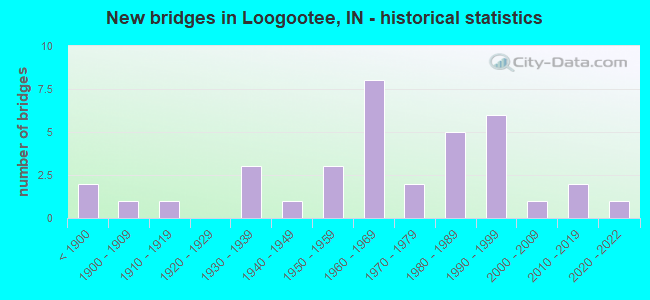
- New bridges - historical statistics
- 2Before 1900
- 11900-1909
- 11910-1919
- 31930-1939
- 11940-1949
- 31950-1959
- 81960-1969
- 21970-1979
- 51980-1989
- 61990-1999
- 12000-2009
- 22010-2019
- 12020-2022

- Reconstructed bridges - Historical Statistics
- 21960-1969
- 01970-1979
- 41980-1989
- 41990-1999
- 12000-2009
- 92010-2019
- 12020-2022


- Bridge Condition - Deck
- 6.7%Excellent
- 10.0%Very good
- 40.0%Good
- 40.0%Satisfactory
- 3.3%Fair

- Bridge Condition - Superstructure
- 3.2%Excellent
- 3.2%Very good
- 45.2%Good
- 41.9%Satisfactory
- 3.2%Fair
- 3.2%Poor

- Bridge Condition - Substructure
- 6.5%Very good
- 58.1%Good
- 25.8%Satisfactory
- 9.7%Fair

- Bridge Condition - Channel
- 15.6%Very good
- 53.1%Good
- 25.0%Satisfactory
- 3.1%Fair
- 3.1%Poor

- Bridge Condition - Culverts
- 60.0%Good
- 40.0%Satisfactory
Find on map >> Show street view
Structure Number: 473, Location: 01.23 W SR 19 (Lat: 40.579200, Lng: -85.951261), Route carried "on" structure: State highway 18, Year Built: 1985, Year Reconstructed: 2016, Status: Open, Structure Length: 2.49m (8.17ft), Average Daily Traffic: 1,324 (year 2020), Truck Traffic: 22%, Average Future Daily Traffic: 2,370 (year 2036), Design Load: HS 20, Features Intersected: HONEY CREEK
Minimum Vertical Clearance: 30+ m (98+ ft), Kilometerpoint: 18.813, Lanes on structure: 2, Owner: State Highway Agency, Approaching Roadway Width: 13.3m (43.6ft), Skew: 1 degrees, Material/Design: Concrete continuous, Design/Construction: Slab, Number Of Spans In Main Unit: 3, Length of Maximum Span: 9.8m (32.2ft), Curb-To-Curb Width: 13.3m (43.6ft), Out-to-Out Width: 14.2m (46.6ft)
Condition: Deck: Good, Superstructure: Good, Substructure: Good, Channel: Very good, Operating Rating: 28.5 metric tons, Method Used To Determine Operating Rating: Load and Resistance Factor Rating (LRFR) rating reported by rating factor(RF) method using HL-93 loadings, Inventory Rating: 22.0 metric tons, Method Used To Determine Inventory Rating: Load and Resistance Factor Rating (LRFR) rating reported by rating factor(RF) method using HL-93 loadings, Structural Evaluation: Somewhat better than minimum adequacy, Deck Geometry: Better than present minimum criteria, Waterway Adequacy: Equal to present desirable criteria, Approach Roadway Alignment: Equal to present desirable criteria, Designated Inspection Frequency: Every 24 months, Inspection Date: August 2021, Deck Structure Type: Concrete Cast-file-Place, Wearing Surface/Protective System: Wearing Surface: Latex Concrete, Deck Protection: Epoxy Coated Reinforcing
Find on map >> Show street view
Structure Number: 922, Location: 06.25 S SR 7 (Lat: 39.076731, Lng: -85.836831), Route carried "on" structure: US 31, Year Built: 1996, Status: Open, Structure Length: 2.77m (9.09ft), Average Daily Traffic: 6,373 (year 2004), Truck Traffic: 10%, Average Future Daily Traffic: 11,172 (year 2031), Design Load: HS 20, Features Intersected: MORTON HALL DITCH
Minimum Vertical Clearance: 30+ m (98+ ft), Kilometerpoint: 1.545, Lanes on structure: 2, Owner: State Highway Agency, Approaching Roadway Width: 12.8m (42.0ft), Skew: 3 degrees, Material/Design: Concrete continuous, Design/Construction: Slab, Number Of Spans In Main Unit: 3, Length of Maximum Span: 10.8m (35.4ft), Curb-To-Curb Width: 13.0m (42.7ft), Out-to-Out Width: 13.9m (45.6ft)
Condition: Deck: Satisfactory, Superstructure: Satisfactory, Substructure: Good, Channel: Good, Operating Rating: 61.9 metric tons, Method Used To Determine Operating Rating: Load and Resistance Factor Rating (LRFR) rating reported by rating factor(RF) method using HL-93 loadings, Inventory Rating: 47.6 metric tons, Method Used To Determine Inventory Rating: Load and Resistance Factor Rating (LRFR) rating reported by rating factor(RF) method using HL-93 loadings, Structural Evaluation: Equal to present minimum criteria, Deck Geometry: Somewhat better than minimum adequacy, Waterway Adequacy: Equal to present desirable criteria, Approach Roadway Alignment: Equal to present desirable criteria, Designated Inspection Frequency: Every 24 months, Inspection Date: June 2020, Deck Structure Type: Concrete Cast-file-Place, Wearing Surface/Protective System: Wearing Surface: Monolithic Concrete, Deck Protection: Epoxy Coated Reinforcing
Find on map >> Show street view
Structure Number: 923, Location: 01.87 S SR 7 (Lat: 39.140061, Lng: -85.839439), Route carried "on" structure: US 31, Year Built: 1972, Year Reconstructed: 2010, Status: Open, Structure Length: 3.29m (10.79ft), Average Daily Traffic: 8,579 (year 2004), Truck Traffic: 10%, Average Future Daily Traffic: 15,133 (year 2031), Design Load: HS 20, Features Intersected: LITTLE SAND CREEK
Minimum Vertical Clearance: 30+ m (98+ ft), Kilometerpoint: 8.594, Lanes on structure: 2, Owner: State Highway Agency, Approaching Roadway Width: 13.1m (43.0ft), Skew: 1 degrees, Material/Design: Prestressed concrete continuous, Design/Construction: Stringer/Multi-beam, Number Of Spans In Main Unit: 3, Length of Maximum Span: 10.7m (35.1ft), Curb-To-Curb Width: 13.2m (43.3ft), Out-to-Out Width: 14.2m (46.6ft)
Condition: Deck: Very good, Superstructure: Satisfactory, Substructure: Good, Channel: Good, Operating Rating: 49.6 metric tons, Method Used To Determine Operating Rating: Load and Resistance Factor Rating (LRFR) rating reported by rating factor(RF) method using HL-93 loadings, Inventory Rating: 38.2 metric tons, Method Used To Determine Inventory Rating: Load and Resistance Factor Rating (LRFR) rating reported by rating factor(RF) method using HL-93 loadings, Structural Evaluation: Equal to present minimum criteria, Deck Geometry: Somewhat better than minimum adequacy, Waterway Adequacy: Better than present minimum criteria, Approach Roadway Alignment: Equal to present desirable criteria, Designated Inspection Frequency: Every 24 months, Inspection Date: June 2020, Deck Structure Type: Concrete Cast-file-Place, Wearing Surface/Protective System: Wearing Surface: Latex Concrete
Find on map >> Show street view
Structure Number: 996, Location: 02.24 N US 24 (Lat: 40.804500, Lng: -86.129039), Route carried "on" structure: US 31, Year Built: 1963, Year Reconstructed: 2019, Status: Open, Structure Length: 8.81m (28.90ft), Average Daily Traffic: 7,410 (year 2018), Truck Traffic: 22%, Average Future Daily Traffic: 8,980 (year 2038), Design Load: HS 20, Features Intersected: EEL RIVER
Minimum Vertical Clearance: 30+ m (98+ ft), Kilometerpoint: 26.763, Lanes on structure: 1, Base Highway Network: Yes (, Subroute: 1), Owner: State Highway Agency, Approaching Roadway Width: 11.6m (38.1ft), Material/Design: Prestressed concrete continuous, Design/Construction: Stringer/Multi-beam, Number Of Spans In Main Unit: 4, Length of Maximum Span: 21.9m (71.9ft), Curb-To-Curb Width: 10.2m (33.5ft), Out-to-Out Width: 11.1m (36.4ft)
Condition: Deck: Satisfactory, Superstructure: Satisfactory, Substructure: Good, Channel: Good, Operating Rating: 28.2 metric tons, Method Used To Determine Operating Rating: Load and Resistance Factor Rating (LRFR) rating reported by rating factor(RF) method using HL-93 loadings, Inventory Rating: 21.7 metric tons, Method Used To Determine Inventory Rating: Load and Resistance Factor Rating (LRFR) rating reported by rating factor(RF) method using HL-93 loadings, Structural Evaluation: Somewhat better than minimum adequacy, Deck Geometry: Meets minimum limits, Waterway Adequacy: Equal to present desirable criteria, Approach Roadway Alignment: Equal to present desirable criteria, Designated Inspection Frequency: Every 24 months, Underwater Inspection Frequency: Every 60 months, Inspection Date: October 2020, Underwater Inspection Date: July 2017, Deck Structure Type: Concrete Cast-file-Place, Wearing Surface/Protective System: Wearing Surface: Latex Concrete
Find on map >> Show street view
Structure Number: 1253, Location: 00.37 S US 35 (Lat: 40.475489, Lng: -85.697161), Route carried "on" structure: State highway 37, Year Built: 1984, Year Reconstructed: 2018, Status: Open, Structure Length: 2.19m (7.19ft), Average Daily Traffic: 3,268 (year 2020), Truck Traffic: 8%, Average Future Daily Traffic: 4,020 (year 2037), Design Load: HS 20, Features Intersected: BELL CREEK
Minimum Vertical Clearance: 30+ m (98+ ft), Kilometerpoint: 13.068, Lanes on structure: 2, Owner: State Highway Agency, Approaching Roadway Width: 13.4m (44.0ft), Skew: 3 degrees, Material/Design: Concrete continuous, Design/Construction: Slab, Number Of Spans In Main Unit: 3, Length of Maximum Span: 8.3m (27.2ft), Curb-To-Curb Width: 13.4m (44.0ft), Out-to-Out Width: 14.3m (46.9ft)
Condition: Deck: Good, Superstructure: Good, Substructure: Good, Channel: Good, Operating Rating: 49.6 metric tons, Method Used To Determine Operating Rating: Load and Resistance Factor (LRFR), Inventory Rating: 36.9 metric tons, Method Used To Determine Inventory Rating: Load and Resistance Factor (LRFR), Structural Evaluation: Better than present minimum criteria, Deck Geometry: Better than present minimum criteria, Waterway Adequacy: Equal to present desirable criteria, Approach Roadway Alignment: Equal to present desirable criteria, Designated Inspection Frequency: Every 24 months, Inspection Date: Febuary 2022, Deck Structure Type: Concrete Cast-file-Place, Wearing Surface/Protective System: Wearing Surface: Latex Concrete, Deck Protection: Epoxy Coated Reinforcing
Find on map >> Show street view
Structure Number: 1584, Location: 02.83 W SR 142 (Lat: 39.499361, Lng: -86.666889), Route carried "on" structure: State highway 42, Year Built: 1968, Year Reconstructed: 1980, Status: Open, Structure Length: 2.87m (9.42ft), Average Daily Traffic: 1,560 (year 2006), Truck Traffic: 5%, Average Future Daily Traffic: 2,590 (year 2030), Design Load: HS 20, Features Intersected: RHODES CREEK
Minimum Vertical Clearance: 30+ m (98+ ft), Kilometerpoint: 1.738, Lanes on structure: 2, Owner: State Highway Agency, Approaching Roadway Width: 6.1m (20.0ft), Material/Design: Prestressed concrete continuous, Design/Construction: Box Beam or Girders - Multiple, Number Of Spans In Main Unit: 3, Length of Maximum Span: 12.8m (42.0ft), Curb or Sidewalk Widths: Left: 0.2m (0.7ft), Right: 0.2m (0.7ft), Curb-To-Curb Width: 9.7m (31.8ft), Out-to-Out Width: 10.5m (34.4ft)
Condition: Deck: Satisfactory, Superstructure: Satisfactory, Substructure: Satisfactory, Channel: Satisfactory, Operating Rating: 38.2 metric tons, Method Used To Determine Operating Rating: Load and Resistance Factor Rating (LRFR) rating reported by rating factor(RF) method using HL-93 loadings, Inventory Rating: 22.4 metric tons, Method Used To Determine Inventory Rating: Load and Resistance Factor Rating (LRFR) rating reported by rating factor(RF) method using HL-93 loadings, Structural Evaluation: Somewhat better than minimum adequacy, Deck Geometry: Somewhat better than minimum adequacy, Waterway Adequacy: Equal to present minimum criteria, Approach Roadway Alignment: Equal to present desirable criteria, Length Of Structure Improvement: 2.87m (9.42ft), Designated Inspection Frequency: Every 24 months, Inspection Date: April 2020, Bridge Improvement Cost: $419,000, Total Project Cost: $419,000, Deck Structure Type: Concrete Cast-file-Place, Wearing Surface/Protective System: Wearing Surface: Latex Concrete, Deck Protection: Epoxy Coated Reinforcing
Find on map >> Show street view
Structure Number: 16761, Location: 02.40 S US 50 (Lat: 38.633761, Lng: -86.914519), Route carried "on" structure: US 231, Year Built: 2013, Status: Open, Structure Length: 3.87m (12.70ft), Average Daily Traffic: 5,519 (year 2007), Truck Traffic: 32%, Average Future Daily Traffic: 7,109 (year 2032), Design Load: HS 25 or greater, Features Intersected: FRIENDS CREEK
Minimum Vertical Clearance: 30+ m (98+ ft), Kilometerpoint: 15.933, Lanes on structure: 2, Base Highway Network: Yes (, Subroute: 1), Owner: State Highway Agency, Approaching Roadway Width: 7.3m (24.0ft), Skew: 3 degrees, Material/Design: Prestressed concrete, Design/Construction: Tee Beam, Number Of Spans In Main Unit: 1, Length of Maximum Span: 37.8m (124.0ft), Curb-To-Curb Width: 13.4m (44.0ft), Out-to-Out Width: 14.0m (45.9ft)
Condition: Deck: Good, Superstructure: Good, Substructure: Good, Channel: Very good, Operating Rating: 72.9 metric tons, Method Used To Determine Operating Rating: Load and Resistance Factor Rating (LRFR) rating reported by rating factor(RF) method using HL-93 loadings, Inventory Rating: 44.1 metric tons, Method Used To Determine Inventory Rating: Load and Resistance Factor Rating (LRFR) rating reported by rating factor(RF) method using HL-93 loadings, Structural Evaluation: Better than present minimum criteria, Deck Geometry: Equal to present minimum criteria, Waterway Adequacy: Superior to present desirable criteria, Approach Roadway Alignment: Equal to present desirable criteria, Designated Inspection Frequency: Every 24 months, Inspection Date: November 2021, Deck Structure Type: Concrete Cast-file-Place, Wearing Surface/Protective System: Wearing Surface: Monolithic Concrete, Deck Protection: Epoxy Coated Reinforcing
Find on map >> Show street view
Structure Number: 1677, Location: 01.94 S US 50 (Lat: 38.640339, Lng: -86.914489), Route carried "on" structure: US 231, Year Built: 1930, Year Reconstructed: 1965, Status: Open, Structure Length: 1.49m (4.89ft), Average Daily Traffic: 6,443 (year 2004), Truck Traffic: 10%, Average Future Daily Traffic: 8,924 (year 2030), Design Load: H 20, Features Intersected: BRANCH FRIENDS CREEK
Minimum Vertical Clearance: 30+ m (98+ ft), Kilometerpoint: 16.673, Lanes on structure: 2, Base Highway Network: Yes (, Subroute: 1), Owner: State Highway Agency, Approaching Roadway Width: 8.5m (27.9ft), Skew: 3 degrees, Material/Design: Concrete, Design/Construction: Arch - Deck, Number Of Spans In Main Unit: 1, Length of Maximum Span: 12.2m (40.0ft), Curb or Sidewalk Widths: Left: 0.1m (0.3ft), Right: 0.1m (0.3ft), Curb-To-Curb Width: 9.4m (30.8ft), Out-to-Out Width: 10.1m (33.1ft)
Condition: Superstructure: Satisfactory, Substructure: Satisfactory, Channel: Good, Operating Rating: 54.5 metric tons, Method Used To Determine Operating Rating: Field evaluation and documented engineering judgment, Inventory Rating: 32.7 metric tons, Method Used To Determine Inventory Rating: Field evaluation and documented engineering judgment, Structural Evaluation: Equal to present minimum criteria, Deck Geometry: High priority of corrective action, Waterway Adequacy: Superior to present desirable criteria, Approach Roadway Alignment: Equal to present desirable criteria, Length Of Structure Improvement: 2.29m (7.51ft), Designated Inspection Frequency: Every 24 months, Inspection Date: November 2021, Bridge Improvement Cost: $380,000, Roadway Improvement Cost: $25,000, Total Project Cost: $405,000, Deck Structure Type: Concrete Cast-file-Place, Wearing Surface/Protective System: Wearing Surface: Bituminous
Find on map >> Show street view
Structure Number: 1678, Location: 00.41 S US 50 (Lat: 38.662711, Lng: -86.914469), Route carried "on" structure: US 231, Year Built: 1992, Status: Open, Structure Length: 1.80m (5.91ft), Average Daily Traffic: 6,851 (year 2004), Truck Traffic: 10%, Average Future Daily Traffic: 9,489 (year 2030), Design Load: H 20, Features Intersected: BRANCH FRIENDS CREEK
Minimum Vertical Clearance: 30+ m (98+ ft), Kilometerpoint: 19.135, Lanes on structure: 2, Base Highway Network: Yes (, Subroute: 1), Owner: State Highway Agency, Approaching Roadway Width: 8.5m (27.9ft), Skew: 3 degrees, Material/Design: Prestressed concrete, Design/Construction: Stringer/Multi-beam, Number Of Spans In Main Unit: 1, Length of Maximum Span: 16.5m (54.1ft), Curb-To-Curb Width: 13.8m (45.3ft), Out-to-Out Width: 14.7m (48.2ft)
Condition: Deck: Good, Superstructure: Satisfactory, Substructure: Good, Channel: Very good, Operating Rating: 53.8 metric tons, Method Used To Determine Operating Rating: Load and Resistance Factor Rating (LRFR) rating reported by rating factor(RF) method using HL-93 loadings, Inventory Rating: 41.5 metric tons, Method Used To Determine Inventory Rating: Load and Resistance Factor Rating (LRFR) rating reported by rating factor(RF) method using HL-93 loadings, Structural Evaluation: Equal to present minimum criteria, Deck Geometry: Superior to present desirable criteria, Waterway Adequacy: Superior to present desirable criteria, Approach Roadway Alignment: Equal to present desirable criteria, Designated Inspection Frequency: Every 24 months, Inspection Date: November 2021, Deck Structure Type: Concrete Cast-file-Place, Wearing Surface/Protective System: Wearing Surface: Monolithic Concrete, Deck Protection: Epoxy Coated Reinforcing
Find on map >> Show street view
Structure Number: 1679, Location: 03.09 N US 50 (Lat: 38.718839, Lng: -86.918931), Route carried "on" structure: US 231, Year Built: 1940, Year Reconstructed: 2016, Status: Open, Structure Length: 2.01m (6.59ft), Average Daily Traffic: 5,613 (year 2004), Truck Traffic: 10%, Average Future Daily Traffic: 7,774 (year 2030), Design Load: H 20, Features Intersected: LITTLE BOGGS CREEK
Minimum Vertical Clearance: 30+ m (98+ ft), Kilometerpoint: 25.524, Lanes on structure: 2, Base Highway Network: Yes (, Subroute: 1), Owner: State Highway Agency, Approaching Roadway Width: 9.1m (29.9ft), Skew: 1 degrees, Material/Design: Steel, Design/Construction: Stringer/Multi-beam, Number Of Spans In Main Unit: 1, Length of Maximum Span: 18.3m (60.0ft), Curb-To-Curb Width: 13.4m (44.0ft), Out-to-Out Width: 14.2m (46.6ft)
Condition: Deck: Good, Superstructure: Good, Substructure: Satisfactory, Channel: Very good, Operating Rating: 31.4 metric tons, Method Used To Determine Operating Rating: Load and Resistance Factor Rating (LRFR) rating reported by rating factor(RF) method using HL-93 loadings, Inventory Rating: 24.3 metric tons, Method Used To Determine Inventory Rating: Load and Resistance Factor Rating (LRFR) rating reported by rating factor(RF) method using HL-93 loadings, Structural Evaluation: Equal to present minimum criteria, Deck Geometry: Equal to present minimum criteria, Waterway Adequacy: Equal to present desirable criteria, Approach Roadway Alignment: Equal to present desirable criteria, Designated Inspection Frequency: Every 24 months, Inspection Date: November 2021, Deck Structure Type: Concrete Cast-file-Place, Wearing Surface/Protective System: Wearing Surface: Latex Concrete, Deck Protection: Epoxy Coated Reinforcing
Find on map >> Show street view
Structure Number: 1835, Location: 01.68 W US 231 (Lat: 38.664269, Lng: -86.944000), Route carried "on" structure: US 50, Year Built: 1995, Status: Open, Structure Length: 0.98m (3.22ft), Average Daily Traffic: 8,331 (year 2004), Truck Traffic: 10%, Average Future Daily Traffic: 11,539 (year 2030), Features Intersected: FLAT CREEK
Minimum Vertical Clearance: 30+ m (98+ ft), Kilometerpoint: 28.743, Lanes on structure: 2, Base Highway Network: Yes (, Subroute: 1), Owner: State Highway Agency, Approaching Roadway Width: 8.5m (27.9ft), Material/Design: Steel, Design/Construction: Culvert, Number Of Spans In Main Unit: 2, Length of Maximum Span: 4.3m (14.1ft)
Condition: Channel: Good, Culverts: Satisfactory, Inventory Rating: 97.2 metric tons, Method Used To Determine Inventory Rating: Load and Resistance Factor Rating (LRFR) rating reported by rating factor(RF) method using HL-93 loadings, Structural Evaluation: Equal to present minimum criteria, Waterway Adequacy: Superior to present desirable criteria, Approach Roadway Alignment: Equal to present desirable criteria, Designated Inspection Frequency: Every 24 months, Inspection Date: December 2021
Find on map >> Show street view
Structure Number: 1836, Location: 00.22 W US 231 (Lat: 38.666900, Lng: -86.917561), Route carried "on" structure: US 50, Year Built: 1930, Year Reconstructed: 1997, Status: Open, Structure Length: 0.79m (2.59ft), Average Daily Traffic: 13,136 (year 2004), Truck Traffic: 5%, Average Future Daily Traffic: 18,509 (year 2030), Design Load: H 20, Features Intersected: BRANCH FRIENDS CREEK
Minimum Vertical Clearance: 30+ m (98+ ft), Kilometerpoint: 0.579, Lanes on structure: 2, Base Highway Network: Yes (, Subroute: 1), Owner: State Highway Agency, Approaching Roadway Width: 7.9m (25.9ft), Skew: 1 degrees, Material/Design: Concrete, Design/Construction: Culvert, Number Of Spans In Main Unit: 1, Length of Maximum Span: 7.3m (24.0ft), Curb-To-Curb Width: 13.0m (42.7ft), Out-to-Out Width: 13.9m (45.6ft)
Condition: Channel: Good, Culverts: Good, Operating Rating: 76.4 metric tons, Method Used To Determine Operating Rating: Field evaluation and documented engineering judgment, Inventory Rating: 45.7 metric tons, Method Used To Determine Inventory Rating: Field evaluation and documented engineering judgment, Structural Evaluation: Better than present minimum criteria, Deck Geometry: Somewhat better than minimum adequacy, Waterway Adequacy: Superior to present desirable criteria, Approach Roadway Alignment: Equal to present desirable criteria, Designated Inspection Frequency: Every 24 months, Inspection Date: December 2021
Find on map >> Show street view
Structure Number: 1837, Location: 01.30 E SR 550 (Lat: 38.683139, Lng: -86.886800), Route carried "on" structure: US 50, Year Built: 1965, Year Reconstructed: 2016, Status: Open, Structure Length: 2.77m (9.09ft), Average Daily Traffic: 8,381 (year 2004), Truck Traffic: 10%, Average Future Daily Traffic: 11,608 (year 2032), Design Load: HS 20, Features Intersected: CSX RR
Minimum Vertical Clearance: 30+ m (98+ ft), Kilometerpoint: 4.249, Lanes on structure: 2, Base Highway Network: Yes (, Subroute: 1), Owner: State Highway Agency, Approaching Roadway Width: 12.2m (40.0ft), Skew: 3 degrees, Material/Design: Steel, Design/Construction: Stringer/Multi-beam, Number Of Spans In Main Unit: 1, Length of Maximum Span: 25.9m (85.0ft), Curb-To-Curb Width: 12.2m (40.0ft), Out-to-Out Width: 13.3m (43.6ft)
Condition: Deck: Good, Superstructure: Good, Substructure: Good, Operating Rating: 39.9 metric tons, Method Used To Determine Operating Rating: Load and Resistance Factor Rating (LRFR) rating reported by rating factor(RF) method using HL-93 loadings, Inventory Rating: 30.8 metric tons, Method Used To Determine Inventory Rating: Load and Resistance Factor Rating (LRFR) rating reported by rating factor(RF) method using HL-93 loadings, Structural Evaluation: Better than present minimum criteria, Deck Geometry: Somewhat better than minimum adequacy, Underclear: Meets minimum limits, Approach Roadway Alignment: Equal to present minimum criteria, Designated Inspection Frequency: Every 24 months, Inspection Date: June 2021, Deck Structure Type: Concrete Cast-file-Place, Wearing Surface/Protective System: Wearing Surface: Latex Concrete
Find on map >> Show street view
Structure Number: 1838, Location: 01.43 E SR 550 (Lat: 38.684139, Lng: -86.884500), Route carried "on" structure: US 50, Year Built: 1970, Year Reconstructed: 2016, Status: Open, Structure Length: 7.68m (25.20ft), Average Daily Traffic: 7,260 (year 2015), Truck Traffic: 17%, Average Future Daily Traffic: 8,860 (year 2035), Design Load: HS 20, Features Intersected: BOGGS CREEK
Minimum Vertical Clearance: 30+ m (98+ ft), Kilometerpoint: 4.458, Lanes on structure: 2, Base Highway Network: Yes (, Subroute: 1), Owner: State Highway Agency, Approaching Roadway Width: 10.4m (34.1ft), Material/Design: Steel continuous, Design/Construction: Stringer/Multi-beam, Number Of Spans In Main Unit: 3, Length of Maximum Span: 29.7m (97.4ft), Curb-To-Curb Width: 10.2m (33.5ft), Out-to-Out Width: 11.1m (36.4ft)
Condition: Deck: Fair, Superstructure: Good, Substructure: Good, Channel: Good, Operating Rating: 40.5 metric tons, Method Used To Determine Operating Rating: Load and Resistance Factor Rating (LRFR) rating reported by rating factor(RF) method using HL-93 loadings, Inventory Rating: 31.1 metric tons, Method Used To Determine Inventory Rating: Load and Resistance Factor Rating (LRFR) rating reported by rating factor(RF) method using HL-93 loadings, Structural Evaluation: Better than present minimum criteria, Deck Geometry: Meets minimum limits, Waterway Adequacy: Superior to present desirable criteria, Approach Roadway Alignment: Equal to present desirable criteria, Designated Inspection Frequency: Every 24 months, Other Special Inspection Frequency: Every 48 months, Inspection Date: June 2021, Other Special Inspection Date: June 2021, Deck Structure Type: Concrete Cast-file-Place, Wearing Surface/Protective System: Wearing Surface: Latex Concrete
Find on map >> Show street view
Structure Number: 2522, Location: 02.40 S SR 1 (Lat: 41.324900, Lng: -84.867519), Route carried "on" structure: State highway 101, Year Built: 1963, Year Reconstructed: 2003, Status: Open, Structure Length: 8.61m (28.25ft), Average Daily Traffic: 2,174 (year 2019), Truck Traffic: 22%, Average Future Daily Traffic: 2,953 (year 2034), Design Load: HS 20, Features Intersected: ST JOSEPH RIVER
Minimum Vertical Clearance: 30+ m (98+ ft), Kilometerpoint: 5.858, Lanes on structure: 2, Owner: State Highway Agency, Approaching Roadway Width: 11.6m (38.1ft), Skew: 2 degrees, Material/Design: Steel continuous, Design/Construction: Stringer/Multi-beam, Number Of Spans In Main Unit: 4, Length of Maximum Span: 23.8m (78.1ft), Curb-To-Curb Width: 11.2m (36.7ft), Out-to-Out Width: 12.1m (39.7ft)
Condition: Deck: Good, Superstructure: Good, Substructure: Satisfactory, Channel: Good, Operating Rating: 58.4 metric tons, Method Used To Determine Operating Rating: Load Factor (LF), Inventory Rating: 34.9 metric tons, Method Used To Determine Inventory Rating: Load Factor (LF), Structural Evaluation: Equal to present minimum criteria, Deck Geometry: Somewhat better than minimum adequacy, Waterway Adequacy: Equal to present desirable criteria, Approach Roadway Alignment: Equal to present desirable criteria, Designated Inspection Frequency: Every 24 months, Underwater Inspection Frequency: Every 60 months, Inspection Date: March 2020, Underwater Inspection Date: May 2018, Deck Structure Type: Concrete Cast-file-Place, Wearing Surface/Protective System: Wearing Surface: Monolithic Concrete, Deck Protection: Epoxy Coated Reinforcing
Find on map >> Show street view
Structure Number: 2526, Location: 01.99 N SR 38 (Lat: 39.958119, Lng: -85.354981), Route carried "on" structure: State highway 103, Year Built: 1987, Status: Open, Structure Length: 3.81m (12.50ft), Average Daily Traffic: 3,969 (year 2004), Truck Traffic: 10%, Average Future Daily Traffic: 6,588 (year 2029), Design Load: HS 20, Features Intersected: LITTLE BLUE RIVER
Minimum Vertical Clearance: 30+ m (98+ ft), Kilometerpoint: 17.317, Lanes on structure: 2, Owner: State Highway Agency, Approaching Roadway Width: 7.3m (24.0ft), Skew: 2 degrees, Material/Design: Prestressed concrete continuous, Design/Construction: Stringer/Multi-beam, Number Of Spans In Main Unit: 3, Length of Maximum Span: 14.1m (46.3ft), Curb-To-Curb Width: 13.4m (44.0ft), Out-to-Out Width: 14.3m (46.9ft)
Condition: Deck: Satisfactory, Superstructure: Satisfactory, Substructure: Good, Channel: Satisfactory, Operating Rating: 35.0 metric tons, Method Used To Determine Operating Rating: Load and Resistance Factor Rating (LRFR) rating reported by rating factor(RF) method using HL-93 loadings, Inventory Rating: 24.3 metric tons, Method Used To Determine Inventory Rating: Load and Resistance Factor Rating (LRFR) rating reported by rating factor(RF) method using HL-93 loadings, Structural Evaluation: Equal to present minimum criteria, Deck Geometry: Better than present minimum criteria, Waterway Adequacy: Superior to present desirable criteria, Approach Roadway Alignment: Equal to present desirable criteria, Designated Inspection Frequency: Every 24 months, Inspection Date: December 2020, Deck Structure Type: Concrete Cast-file-Place, Wearing Surface/Protective System: Wearing Surface: Monolithic Concrete, Deck Protection: Epoxy Coated Reinforcing
Find on map >> Show street view
Structure Number: 2528, Location: 02.10 N SR 124 (Lat: 40.771181, Lng: -85.621419), Route carried "on" structure: State highway 105, Year Built: 1965, Year Reconstructed: 2020, Status: Open, Structure Length: 18.59m (60.99ft), Average Daily Traffic: 650 (year 2019), Truck Traffic: 6%, Average Future Daily Traffic: 750 (year 2040), Design Load: HS 20, Features Intersected: SALAMONIE RIVER - RESRVR
Minimum Vertical Clearance: 30+ m (98+ ft), Kilometerpoint: 12.601, Lanes on structure: 2, Owner: State Highway Agency, Approaching Roadway Width: 10.2m (33.5ft), Material/Design: Prestressed concrete continuous, Design/Construction: Stringer/Multi-beam, Number Of Spans In Main Unit: 7, Length of Maximum Span: 26.5m (86.9ft), Curb-To-Curb Width: 10.2m (33.5ft), Out-to-Out Width: 10.9m (35.8ft)
Condition: Deck: Excellent, Superstructure: Excellent, Substructure: Fair, Channel: Good, Operating Rating: 51.5 metric tons, Method Used To Determine Operating Rating: Load and Resistance Factor Rating (LRFR) rating reported by rating factor(RF) method using HL-93 loadings, Inventory Rating: 24.9 metric tons, Method Used To Determine Inventory Rating: Load and Resistance Factor Rating (LRFR) rating reported by rating factor(RF) method using HL-93 loadings, Structural Evaluation: Somewhat better than minimum adequacy, Deck Geometry: Equal to present minimum criteria, Waterway Adequacy: Equal to present desirable criteria, Approach Roadway Alignment: Equal to present desirable criteria, Designated Inspection Frequency: Every 24 months, Underwater Inspection Frequency: Every 60 months, Inspection Date: October 2020, Underwater Inspection Date: November 2017, Deck Structure Type: Concrete Cast-file-Place, Wearing Surface/Protective System: Wearing Surface: Monolithic Concrete, Deck Protection: Epoxy Coated Reinforcing
Find on map >> Show street view
Structure Number: 2532, Location: 02.89 S SR 114 (Lat: 40.960450, Lng: -85.624000), Route carried "on" structure: State highway 105, Year Built: 1987, Status: Open, Structure Length: 2.10m (6.89ft), Average Daily Traffic: 798 (year 2021), Truck Traffic: 11%, Average Future Daily Traffic: 1,840 (year 2032), Design Load: HS 20, Features Intersected: CARROLL DITCH
Minimum Vertical Clearance: 30+ m (98+ ft), Kilometerpoint: 38.335, Lanes on structure: 2, Owner: State Highway Agency, Approaching Roadway Width: 12.5m (41.0ft), Skew: 1 degrees, Material/Design: Concrete continuous, Design/Construction: Slab, Number Of Spans In Main Unit: 3, Length of Maximum Span: 8.1m (26.6ft), Curb-To-Curb Width: 12.5m (41.0ft), Out-to-Out Width: 13.6m (44.6ft)
Condition: Deck: Satisfactory, Superstructure: Satisfactory, Substructure: Good, Channel: Good, Operating Rating: 47.3 metric tons, Method Used To Determine Operating Rating: Load and Resistance Factor Rating (LRFR) rating reported by rating factor(RF) method using HL-93 loadings, Inventory Rating: 36.3 metric tons, Method Used To Determine Inventory Rating: Load and Resistance Factor Rating (LRFR) rating reported by rating factor(RF) method using HL-93 loadings, Structural Evaluation: Equal to present minimum criteria, Deck Geometry: Superior to present desirable criteria, Waterway Adequacy: Equal to present desirable criteria, Approach Roadway Alignment: Equal to present desirable criteria, Designated Inspection Frequency: Every 24 months, Inspection Date: April 2022, Deck Structure Type: Concrete Cast-file-Place, Wearing Surface/Protective System: Wearing Surface: Monolithic Concrete, Deck Protection: Epoxy Coated Reinforcing
Find on map >> Show street view
Structure Number: 2551, Location: 08.11 S SR 211 (Lat: 38.021781, Lng: -85.942461), Route carried "on" structure: County highway 111, Year Built: 1967, Year Reconstructed: 1980, Status: Open, Structure Length: 1.52m (4.99ft), Average Daily Traffic: 367 (year 2004), Truck Traffic: 10%, Average Future Daily Traffic: 613 (year 2031), Design Load: HS 20, Features Intersected: MACAULEY CREEK
Minimum Vertical Clearance: 30+ m (98+ ft), Kilometerpoint: 7.210, Lanes on structure: 2, Owner: County Highway Agency, Approaching Roadway Width: 7.3m (24.0ft), Material/Design: Prestressed concrete, Design/Construction: Box Beam or Girders - Multiple, Number Of Spans In Main Unit: 1, Length of Maximum Span: 14.0m (45.9ft), Curb or Sidewalk Widths: Left: 0.3m (1.0ft), Right: 0.3m (1.0ft), Curb-To-Curb Width: 8.7m (28.5ft), Out-to-Out Width: 9.3m (30.5ft)
Condition: Deck: Good, Superstructure: Good, Substructure: Good, Channel: Good, Operating Rating: 58.1 metric tons, Method Used To Determine Operating Rating: Load Factor (LF), Inventory Rating: 33.9 metric tons, Method Used To Determine Inventory Rating: Load Factor (LF), Structural Evaluation: Better than present minimum criteria, Deck Geometry: Equal to present minimum criteria, Waterway Adequacy: Equal to present desirable criteria, Approach Roadway Alignment: Equal to present desirable criteria, Designated Inspection Frequency: Every 24 months, Inspection Date: June 2020, Deck Structure Type: Concrete Cast-file-Place, Wearing Surface/Protective System: Wearing Surface: Latex Concrete, Deck Protection: Epoxy Coated Reinforcing
Find on map >> Show street view
Structure Number: 2568, Location: 00.89 W US 421 (Lat: 40.934069, Lng: -86.908669), Route carried "on" structure: State highway 114, Year Built: 1935, Year Reconstructed: 2002, Status: Open, Structure Length: 0.91m (2.99ft), Average Daily Traffic: 1,552 (year 2020), Truck Traffic: 38%, Average Future Daily Traffic: 2,229 (year 2030), Design Load: HS 20, Features Intersected: MP HILL DITCH
Minimum Vertical Clearance: 30+ m (98+ ft), Kilometerpoint: 1.851, Lanes on structure: 2, Owner: State Highway Agency, Approaching Roadway Width: 9.8m (32.2ft), Skew: 1 degrees, Material/Design: Prestressed concrete, Design/Construction: Box Beam or Girders - Multiple, Number Of Spans In Main Unit: 1, Length of Maximum Span: 8.5m (27.9ft), Curb-To-Curb Width: 10.4m (34.1ft), Out-to-Out Width: 11.3m (37.1ft)
Condition: Deck: Satisfactory, Superstructure: Good, Substructure: Satisfactory, Channel: Poor, Operating Rating: 34.3 metric tons, Method Used To Determine Operating Rating: Load and Resistance Factor Rating (LRFR) rating reported by rating factor(RF) method using HL-93 loadings, Inventory Rating: 26.6 metric tons, Method Used To Determine Inventory Rating: Load and Resistance Factor Rating (LRFR) rating reported by rating factor(RF) method using HL-93 loadings, Structural Evaluation: Equal to present minimum criteria, Deck Geometry: Equal to present minimum criteria, Waterway Adequacy: Equal to present desirable criteria, Approach Roadway Alignment: Equal to present desirable criteria, Designated Inspection Frequency: Every 24 months, Inspection Date: Febuary 2022, Deck Structure Type: Concrete Cast-file-Place, Wearing Surface/Protective System: Wearing Surface: Latex Concrete
Find on map >> Show street view
Structure Number: 3299, Location: 02.64 E US 50 (Lat: 38.647311, Lng: -86.886331), Route carried "on" structure: State highway 550, Year Built: 1988, Status: Open, Structure Length: 14.60m (47.90ft), Average Daily Traffic: 424 (year 2004), Truck Traffic: 10%, Average Future Daily Traffic: 705 (year 2030), Design Load: HS 20, Features Intersected: EAST FORK WHITE RIVER
Minimum Vertical Clearance: 30+ m (98+ ft), Kilometerpoint: 4.249, Lanes on structure: 2, Owner: State Highway Agency, Approaching Roadway Width: 6.7m (22.0ft), Material/Design: Steel continuous, Design/Construction: Stringer/Multi-beam, Number Of Spans In Main Unit: 4, Length of Maximum Span: 40.2m (131.9ft), Curb-To-Curb Width: 10.4m (34.1ft), Out-to-Out Width: 11.3m (37.1ft)
Condition: Deck: Satisfactory, Superstructure: Good, Substructure: Good, Channel: Good, Operating Rating: 38.9 metric tons, Method Used To Determine Operating Rating: Load and Resistance Factor Rating (LRFR) rating reported by rating factor(RF) method using HL-93 loadings, Inventory Rating: 29.8 metric tons, Method Used To Determine Inventory Rating: Load and Resistance Factor Rating (LRFR) rating reported by rating factor(RF) method using HL-93 loadings, Structural Evaluation: Better than present minimum criteria, Deck Geometry: Equal to present minimum criteria, Waterway Adequacy: Superior to present desirable criteria, Approach Roadway Alignment: Equal to present desirable criteria, Designated Inspection Frequency: Every 24 months, Underwater Inspection Frequency: Every 60 months, Inspection Date: June 2021, Underwater Inspection Date: September 2018, Deck Structure Type: Concrete Cast-file-Place, Wearing Surface/Protective System: Wearing Surface: Monolithic Concrete, Deck Protection: Epoxy Coated Reinforcing
Find on map >> Show street view
Structure Number: 4729, Location: 00.71 W SR 39 (Lat: 41.659350, Lng: -86.751678), Route carried "on" structure: Interstate 90, Year Built: 1956, Year Reconstructed: 2018, Status: Open, Structure Length: 8.44m (27.69ft), Average Daily Traffic: 12,615 (year 2014), Truck Traffic: 24%, Average Future Daily Traffic: 26,276 (year 2031), Design Load: HS 20+Mod, Features Intersected: CONRAIL/CSX RR
Minimum Vertical Clearance: 30+ m (98+ ft), Kilometerpoint: 77.554, Lanes on structure: 2, Base Highway Network: Yes (, Subroute: 1), Toll: On toll road, Owner: State Toll Authority, Approaching Roadway Width: 12.8m (42.0ft), Skew: 1 degrees, Material/Design: Steel continuous, Design/Construction: Stringer/Multi-beam, Number Of Spans In Main Unit: 4, Length of Maximum Span: 23.2m (76.1ft), Curb-To-Curb Width: 9.8m (32.2ft), Out-to-Out Width: 10.7m (35.1ft)
Condition: Deck: Very good, Superstructure: Satisfactory, Substructure: Good, Operating Rating: 63.5 metric tons, Method Used To Determine Operating Rating: Load Factor (LF), Inventory Rating: 38.0 metric tons, Method Used To Determine Inventory Rating: Load Factor (LF), Structural Evaluation: Equal to present minimum criteria, Deck Geometry: Meets minimum limits, Underclear: Somewhat better than minimum adequacy, Approach Roadway Alignment: Equal to present desirable criteria, Designated Inspection Frequency: Every 24 months, Inspection Date: July 2021, Deck Structure Type: Concrete Cast-file-Place, Wearing Surface/Protective System: Wearing Surface: Latex Concrete
Find on map >> Show street view
Structure Number: 4731, Location: 01.41 E US 35 (Lat: 41.663231, Lng: -86.738664), Route carried "on" structure: Interstate 90, Year Built: 1956, Year Reconstructed: 1987, Status: Open, Structure Length: 4.48m (14.70ft), Average Daily Traffic: 12,615 (year 2014), Truck Traffic: 24%, Average Future Daily Traffic: 26,276 (year 2031), Design Load: HS 20, Features Intersected: SR 39
Minimum Vertical Clearance: 30+ m (98+ ft), Kilometerpoint: 78.697, Lanes on structure: 2, Lanes under structure: 2, Base Highway Network: Yes (, Subroute: 1), Toll: On toll road, Owner: State Toll Authority, Approaching Roadway Width: 12.8m (42.0ft), Skew: 2 degrees, Material/Design: Steel continuous, Design/Construction: Stringer/Multi-beam, Number Of Spans In Main Unit: 3, Length of Maximum Span: 14.3m (46.9ft), Curb-To-Curb Width: 9.8m (32.2ft), Out-to-Out Width: 10.7m (35.1ft)
Condition: Deck: Satisfactory, Superstructure: Satisfactory, Substructure: Good, Operating Rating: 48.6 metric tons, Method Used To Determine Operating Rating: Load and Resistance Factor Rating (LRFR) rating reported by rating factor(RF) method using HL-93 loadings, Inventory Rating: 37.6 metric tons, Method Used To Determine Inventory Rating: Load and Resistance Factor Rating (LRFR) rating reported by rating factor(RF) method using HL-93 loadings, Structural Evaluation: Equal to present minimum criteria, Deck Geometry: High priority of replacement, Underclear: Meets minimum limits, Approach Roadway Alignment: Equal to present desirable criteria, Designated Inspection Frequency: Every 24 months, Inspection Date: July 2021, Deck Structure Type: Concrete Cast-file-Place, Wearing Surface/Protective System: Wearing Surface: Latex Concrete
Find on map >> Show street view
Structure Number: 4733, Location: 00.42 E SR 39 (Lat: 41.666189, Lng: -86.731536), Route carried "on" structure: Ramp Interstate 90, Year Built: 1956, Year Reconstructed: 2018, Status: Open, Structure Length: 8.02m (26.31ft), Average Daily Traffic: 1,660 (year 2014), Truck Traffic: 10%, Average Future Daily Traffic: 7,647 (year 2031), Design Load: HS 20+Mod, Features Intersected: I-90 EB/WB
Minimum Vertical Clearance: 30+ m (98+ ft), Kilometerpoint: 79.373, Lanes on structure: 2, Lanes under structure: 4, Base Highway Network: Yes (, Subroute: 1), Toll: On toll road, Owner: State Toll Authority, Approaching Roadway Width: 10.7m (35.1ft), Skew: 20 degrees, Material/Design: Steel, Design/Construction: Stringer/Multi-beam, Number Of Spans In Main Unit: 4, Length of Maximum Span: 23.2m (76.1ft), Curb or Sidewalk Widths: Left: 0.6m (2.0ft), Right: 0.6m (2.0ft), Curb-To-Curb Width: 10.4m (34.1ft), Out-to-Out Width: 10.7m (35.1ft)
Condition: Deck: Excellent, Superstructure: Satisfactory, Substructure: Good, Operating Rating: 85.6 metric tons, Method Used To Determine Operating Rating: Load Factor (LF), Inventory Rating: 51.3 metric tons, Method Used To Determine Inventory Rating: Load Factor (LF), Structural Evaluation: Equal to present minimum criteria, Deck Geometry: Better than present minimum criteria, Underclear: Meets minimum limits, Approach Roadway Alignment: Equal to present desirable criteria, Designated Inspection Frequency: Every 24 months, Inspection Date: July 2021, Deck Structure Type: Concrete Cast-file-Place, Wearing Surface/Protective System: Wearing Surface: Latex Concrete
Find on map >> Show street view
Structure Number: 7648, Location: 03.58 E US 50 (Lat: 38.641119, Lng: -86.870381), Route carried "on" structure: State highway 550, Year Built: 1999, Status: Open, Structure Length: 0.70m (2.30ft), Average Daily Traffic: 424 (year 2004), Truck Traffic: 10%, Average Future Daily Traffic: 705 (year 2032), Design Load: HS 20, Features Intersected: POPLAR CREEK
Minimum Vertical Clearance: 30+ m (98+ ft), Kilometerpoint: 5.761, Lanes on structure: 2, Owner: State Highway Agency, Approaching Roadway Width: 6.7m (22.0ft), Skew: 1 degrees, Material/Design: Concrete, Design/Construction: Culvert, Number Of Spans In Main Unit: 1, Length of Maximum Span: 6.1m (20.0ft), Curb-To-Curb Width: 7.3m (24.0ft), Out-to-Out Width: 13.4m (44.0ft)
Condition: Channel: Satisfactory, Culverts: Good, Operating Rating: 54.5 metric tons, Method Used To Determine Operating Rating: Field evaluation and documented engineering judgment, Inventory Rating: 32.7 metric tons, Method Used To Determine Inventory Rating: Field evaluation and documented engineering judgment, Structural Evaluation: Better than present minimum criteria, Deck Geometry: Meets minimum limits, Waterway Adequacy: Superior to present desirable criteria, Approach Roadway Alignment: Equal to present desirable criteria, Designated Inspection Frequency: Every 24 months, Inspection Date: May 2020
Find on map >> Show street view
Structure Number: 1400102, Location: 00.37 S of CR 200 S (Lat: 38.622281, Lng: -86.942889), Route carried "on" structure: County highway 81, Year Built: 1961, Status: Open, Structure Length: 1.52m (4.99ft), Average Daily Traffic: 302 (year 2013), Truck Traffic: 12%, Average Future Daily Traffic: 395 (year 2033), Design Load: HS 20, Features Intersected: HAW CREEK, Facility Carried by Structure: CR 1200E
Minimum Vertical Clearance: 30+ m (98+ ft), Kilometerpoint: 0.000, Lanes on structure: 2, Owner: County Highway Agency, Approaching Roadway Width: 6.7m (22.0ft), Material/Design: Prestressed concrete, Design/Construction: Box Beam or Girders - Multiple, Number Of Spans In Main Unit: 1, Length of Maximum Span: 14.0m (45.9ft), Curb or Sidewalk Widths: Left: 0.2m (0.7ft), Right: 0.2m (0.7ft), Curb-To-Curb Width: 8.0m (26.2ft), Out-to-Out Width: 8.6m (28.2ft)
Condition: Deck: Satisfactory, Superstructure: Satisfactory, Substructure: Good, Channel: Good, Operating Rating: 73.3 metric tons, Method Used To Determine Operating Rating: Load Factor (LF), Inventory Rating: 43.9 metric tons, Method Used To Determine Inventory Rating: Load Factor (LF), Structural Evaluation: Equal to present minimum criteria, Deck Geometry: Somewhat better than minimum adequacy, Waterway Adequacy: Somewhat better than minimum adequacy, Approach Roadway Alignment: Equal to present desirable criteria, Designated Inspection Frequency: Every 24 months, Inspection Date: June 2021, Deck Structure Type: Concrete Precast Panels, Wearing Surface/Protective System: Wearing Surface: Bituminous, Membrane: Preformed Fabric
Find on map >> Show street view
Structure Number: 5100007, Location: 0.18 E OF CRANE ROAD (Lat: 38.716511, Lng: -86.864911), Route carried "on" structure: Alternate County highway , Year Built: 1897, Year Reconstructed: 2005, Status: Open, Structure Length: 2.19m (7.19ft), Average Daily Traffic: 159 (year 2007), Truck Traffic: 6%, Average Future Daily Traffic: 188 (year 2032), Features Intersected: BOGGS CREEK, Facility Carried by Structure: WILDMAN ROAD
Minimum Vertical Clearance: 30+ m (98+ ft), Kilometerpoint: 0.000, Lanes on structure: 2, Owner: County Highway Agency, Approaching Roadway Width: 4.9m (16.1ft), Material/Design: Steel, Design/Construction: Stringer/Multi-beam, Number Of Spans In Main Unit: 1, Length of Maximum Span: 20.9m (68.6ft), Curb-To-Curb Width: 6.4m (21.0ft), Out-to-Out Width: 6.4m (21.0ft)
Condition: Deck: Good, Superstructure: Good, Substructure: Good, Channel: Good, Operating Rating: 46.2 metric tons, Method Used To Determine Operating Rating: Load Factor (LF), Inventory Rating: 27.7 metric tons, Method Used To Determine Inventory Rating: Load Factor (LF), Structural Evaluation: Equal to present minimum criteria, Deck Geometry: Meets minimum limits, Waterway Adequacy: Equal to present desirable criteria, Approach Roadway Alignment: High priority of corrective action, Designated Inspection Frequency: Every 24 months, Inspection Date: November 2021, Deck Structure Type: Open Grating
Find on map >> Show street view
Structure Number: 5100008, Location: 0.16 W OF CRANE ROAD (Lat: 38.727711, Lng: -86.871189), Route carried "on" structure: Alternate County highway , Year Built: 1998, Status: Posted for load, Structure Length: 1.45m (4.76ft), Average Daily Traffic: 34 (year 2007), Truck Traffic: 5%, Average Future Daily Traffic: 46 (year 2032), Design Load: HS 20, Features Intersected: SEED TICK CREEK, Facility Carried by Structure: KILLION MILL ROAD
Minimum Vertical Clearance: 30+ m (98+ ft), Kilometerpoint: 0.000, Lanes on structure: 2, Owner: County Highway Agency, Approaching Roadway Width: 5.5m (18.0ft), Skew: 1 degrees, Material/Design: Steel, Design/Construction: Stringer/Multi-beam, Number Of Spans In Main Unit: 1, Length of Maximum Span: 12.8m (42.0ft), Curb-To-Curb Width: 7.4m (24.3ft), Out-to-Out Width: 7.6m (24.9ft)
Condition: Deck: Good, Superstructure: Good, Substructure: Very good, Channel: Good, Operating Rating: 41.5 metric tons, Method Used To Determine Operating Rating: Load Factor (LF), Inventory Rating: 24.8 metric tons, Method Used To Determine Inventory Rating: Load Factor (LF), Structural Evaluation: Equal to present minimum criteria, Deck Geometry: Equal to present minimum criteria, Waterway Adequacy: Better than present minimum criteria, Approach Roadway Alignment: Equal to present desirable criteria, Designated Inspection Frequency: Every 24 months, Inspection Date: November 2021, Deck Structure Type: Concrete Cast-file-Place, Wearing Surface/Protective System: Wearing Surface: Monolithic Concrete
Find on map >> Show street view
Structure Number: 5100012, Location: 0.21 N OF BRICKYARD ROAD (Lat: 38.693339, Lng: -86.888150), Route carried "on" structure: Alternate County highway , Year Built: 1969, Status: Open, Structure Length: 2.26m (7.41ft), Average Daily Traffic: 430 (year 2007), Truck Traffic: 6%, Average Future Daily Traffic: 454 (year 2032), Features Intersected: WEST BOGGS CREEK, Facility Carried by Structure: CHERRY ROAD
Minimum Vertical Clearance: 30+ m (98+ ft), Kilometerpoint: 0.000, Lanes on structure: 2, Owner: County Highway Agency, Approaching Roadway Width: 5.5m (18.0ft), Material/Design: Prestressed concrete, Design/Construction: Stringer/Multi-beam, Number Of Spans In Main Unit: 2, Length of Maximum Span: 12.1m (39.7ft), Curb-To-Curb Width: 7.2m (23.6ft), Out-to-Out Width: 7.3m (24.0ft)
Condition: Deck: Satisfactory, Superstructure: Good, Substructure: Satisfactory, Channel: Satisfactory, Operating Rating: 51.5 metric tons, Method Used To Determine Operating Rating: Load Factor (LF), Inventory Rating: 30.8 metric tons, Method Used To Determine Inventory Rating: Load Factor (LF), Structural Evaluation: Equal to present minimum criteria, Deck Geometry: Meets minimum limits, Waterway Adequacy: Equal to present minimum criteria, Approach Roadway Alignment: Equal to present minimum criteria, Designated Inspection Frequency: Every 24 months, Inspection Date: November 2021, Deck Structure Type: Concrete Precast Panels, Wearing Surface/Protective System: Wearing Surface: Monolithic Concrete
Find on map >> Show street view
Structure Number: 5100013, Location: 0.04 N OF WOOD SCHOOL RD (Lat: 38.715161, Lng: -86.904681), Route carried "on" structure: Alternate County highway , Year Built: 1995, Status: Open, Structure Length: 1.04m (3.41ft), Average Daily Traffic: 159 (year 2007), Truck Traffic: 6%, Average Future Daily Traffic: 187 (year 2032), Features Intersected: WEST BOGGS CREEK, Facility Carried by Structure: MOUNT CALVARY ROAD
Minimum Vertical Clearance: 30+ m (98+ ft), Kilometerpoint: 0.000, Lanes on structure: 2, Owner: County Highway Agency, Approaching Roadway Width: 4.6m (15.1ft), Material/Design: Steel, Design/Construction: Stringer/Multi-beam, Number Of Spans In Main Unit: 1, Length of Maximum Span: 9.8m (32.2ft), Curb-To-Curb Width: 5.5m (18.0ft), Out-to-Out Width: 5.5m (18.0ft)
Condition: Deck: Good, Superstructure: Satisfactory, Substructure: Satisfactory, Channel: Satisfactory, Operating Rating: 62.8 metric tons, Method Used To Determine Operating Rating: Load Factor (LF), Inventory Rating: 37.6 metric tons, Method Used To Determine Inventory Rating: Load Factor (LF), Structural Evaluation: Equal to present minimum criteria, Deck Geometry: High priority of corrective action, Waterway Adequacy: Meets minimum limits, Approach Roadway Alignment: Equal to present minimum criteria, Designated Inspection Frequency: Every 24 months, Inspection Date: November 2021, Deck Structure Type: Open Grating
Find on map >> Show street view
Structure Number: 5100014, Location: 0.14 W LOVE CEMETERY ROAD (Lat: 38.701089, Lng: -86.889419), Route carried "on" structure: Alternate County highway , Year Built: 1900, Year Reconstructed: 1969, Status: Open, Structure Length: 1.43m (4.69ft), Average Daily Traffic: 63 (year 2007), Truck Traffic: 5%, Average Future Daily Traffic: 76 (year 2032), Features Intersected: WEST BOGGS CREEK, Facility Carried by Structure: REINHART ROAD
Minimum Vertical Clearance: 30+ m (98+ ft), Kilometerpoint: 0.000, Lanes on structure: 2, Owner: County Highway Agency, Approaching Roadway Width: 4.9m (16.1ft), Material/Design: Prestressed concrete, Design/Construction: Box Beam or Girders - Multiple, Number Of Spans In Main Unit: 1, Length of Maximum Span: 13.1m (43.0ft), Curb-To-Curb Width: 5.4m (17.7ft), Out-to-Out Width: 5.6m (18.4ft)
Condition: Deck: Good, Superstructure: Good, Substructure: Fair, Channel: Fair, Operating Rating: 56.2 metric tons, Method Used To Determine Operating Rating: Load Factor (LF), Inventory Rating: 33.7 metric tons, Method Used To Determine Inventory Rating: Load Factor (LF), Structural Evaluation: Somewhat better than minimum adequacy, Deck Geometry: High priority of corrective action, Waterway Adequacy: Meets minimum limits, Approach Roadway Alignment: Equal to present desirable criteria, Designated Inspection Frequency: Every 24 months, Inspection Date: November 2021, Deck Structure Type: Concrete Precast Panels, Wearing Surface/Protective System: Wearing Surface: Bituminous
Find on map >> Show street view
Structure Number: 5100029, Location: 0.04 N OF US 50 (Lat: 38.685089, Lng: -86.883700), Route carried "on" structure: Alternate County highway , Year Built: 1848, Year Reconstructed: 1996, Status: Posted for load, Structure Length: 4.58m (15.03ft), Average Daily Traffic: 430 (year 2007), Average Future Daily Traffic: 455 (year 2032), Features Intersected: BOGGS CREEK, Facility Carried by Structure: BRICKYARD ROAD
Minimum Vertical Clearance: 30+ m (98+ ft), Kilometerpoint: 0.000, Lanes on structure: 1, Owner: County Highway Agency, Approaching Roadway Width: 4.9m (16.1ft), Material/Design: Steel, Design/Construction: Truss - Deck, Number Of Spans In Main Unit: 1, Number Of Approach Spans: 2, Length of Maximum Span: 26.2m (86.0ft), Curb-To-Curb Width: 3.6m (11.8ft), Out-to-Out Width: 3.7m (12.1ft)
Condition: Deck: Satisfactory, Superstructure: Fair, Substructure: Fair, Channel: Good, Operating Rating: 28.0 metric tons, Method Used To Determine Operating Rating: Load Factor (LF), Inventory Rating: 16.8 metric tons, Method Used To Determine Inventory Rating: Load Factor (LF), Structural Evaluation: Somewhat better than minimum adequacy, Deck Geometry: High priority of replacement, Waterway Adequacy: Superior to present desirable criteria, Approach Roadway Alignment: High priority of corrective action, Bridge Posting: Required (Relationship of Operating Rating to Maximum Legal Load: 10.0 - 19.9% below), Length Of Structure Improvement: 5.12m (16.80ft), Designated Inspection Frequency: Every 24 months, Critical Feature Inspection Frequency: Every 24 months, Inspection Date: November 2021, Critical Feature Inspection Date: November 2021, Bridge Improvement Cost: $1,200,000, Roadway Improvement Cost: $500,000, Total Project Cost: $1,700,000 ( Estimate for 2021), Deck Structure Type: Open Grating
Find on map >> Show street view
Structure Number: 5100034, Location: 0.58 N BROOKS BRIDGE ROAD (Lat: 38.625469, Lng: -86.900450), Route carried "on" structure: Alternate County highway , Year Built: 1910, Year Reconstructed: 1992, Status: Posted for load, Structure Length: 1.38m (4.53ft), Average Daily Traffic: 52 (year 2007), Truck Traffic: 5%, Average Future Daily Traffic: 64 (year 2032), Features Intersected: FRIENDS CREEK, Facility Carried by Structure: FRIENDS CREEK ROAD
Minimum Vertical Clearance: 30+ m (98+ ft), Kilometerpoint: 0.000, Lanes on structure: 1, Owner: County Highway Agency, Approaching Roadway Width: 3.7m (12.1ft), Material/Design: Steel, Design/Construction: Truss - Thru, Number Of Spans In Main Unit: 1, Length of Maximum Span: 12.2m (40.0ft), Curb-To-Curb Width: 3.7m (12.1ft), Out-to-Out Width: 3.7m (12.1ft)
Condition: Deck: Satisfactory, Superstructure: Poor, Substructure: Satisfactory, Channel: Satisfactory, Operating Rating: 22.0 metric tons, Method Used To Determine Operating Rating: Load Factor (LF), Inventory Rating: 13.2 metric tons, Method Used To Determine Inventory Rating: Load Factor (LF), Structural Evaluation: Meets minimum limits, Deck Geometry: Meets minimum limits, Waterway Adequacy: Meets minimum limits, Approach Roadway Alignment: Equal to present minimum criteria, Bridge Posting: Required (Relationship of Operating Rating to Maximum Legal Load: 30.0 - 39.9% below), Length Of Structure Improvement: 1.83m (6.00ft), Designated Inspection Frequency: Every 12 months, Critical Feature Inspection Frequency: Every 24 months, Other Special Inspection Frequency: Every 24 months, Inspection Date: November 2021, Critical Feature Inspection Date: November 2021, Other Special Inspection Date: November 2020, Bridge Improvement Cost: $250,000, Roadway Improvement Cost: $200,000, Total Project Cost: $450,000 ( Estimate for 2020), Deck Structure Type: Open Grating
Find on map >> Show street view
Structure Number: 5100066, Location: 0.23 N OF DAY ROAD (Lat: 38.736889, Lng: -86.877369), Route carried "on" structure: Alternate County highway , Year Built: 2009, Status: Open, Structure Length: 0.90m (2.95ft), Average Daily Traffic: 190 (year 2007), Truck Traffic: 6%, Average Future Daily Traffic: 217 (year 2032), Features Intersected: SEED TICK CREEK, Facility Carried by Structure: LOVE CEMETERY ROAD
Minimum Vertical Clearance: 30+ m (98+ ft), Kilometerpoint: 0.000, Lanes on structure: 2, Owner: County Highway Agency, Approaching Roadway Width: 4.0m (13.1ft), Skew: 1 degrees, Material/Design: Steel, Design/Construction: Culvert, Number Of Spans In Main Unit: 2, Length of Maximum Span: 3.7m (12.1ft), Curb-To-Curb Width: 5.8m (19.0ft), Out-to-Out Width: 5.8m (19.0ft)
Condition: Channel: Satisfactory, Culverts: Satisfactory, Operating Rating: 32.7 metric tons, Method Used To Determine Operating Rating: Field evaluation and documented engineering judgment, Inventory Rating: 32.7 metric tons, Method Used To Determine Inventory Rating: Field evaluation and documented engineering judgment, Structural Evaluation: Equal to present minimum criteria, Deck Geometry: High priority of corrective action, Waterway Adequacy: Better than present minimum criteria, Approach Roadway Alignment: Equal to present desirable criteria, Designated Inspection Frequency: Every 24 months, Inspection Date: November 2021
Find on map >> Show street view
Structure Number: 5100072, Location: 0.08 S OF KILLION MILL (Lat: 38.726511, Lng: -86.868119), Route carried "on" structure: Alternate County highway 143, Year Built: 2017, Status: Open, Structure Length: 1.10m (3.61ft), Average Daily Traffic: 63 (year 2007), Truck Traffic: 5%, Average Future Daily Traffic: 76 (year 2032), Features Intersected: SEED TICK CREEK, Facility Carried by Structure: CRANE ROAD
Minimum Vertical Clearance: 30+ m (98+ ft), Kilometerpoint: 0.000, Lanes on structure: 2, Owner: County Highway Agency, Approaching Roadway Width: 5.2m (17.1ft), Material/Design: Concrete, Design/Construction: Culvert, Number Of Spans In Main Unit: 1, Length of Maximum Span: 10.4m (34.1ft), Curb-To-Curb Width: 7.5m (24.6ft), Out-to-Out Width: 7.7m (25.3ft)
Condition: Channel: Satisfactory, Culverts: Good, Operating Rating: 61.6 metric tons, Method Used To Determine Operating Rating: Load and Resistance Factor Rating (LRFR) rating reported by rating factor(RF) method using HL-93 loadings, Inventory Rating: 47.6 metric tons, Method Used To Determine Inventory Rating: Load and Resistance Factor Rating (LRFR) rating reported by rating factor(RF) method using HL-93 loadings, Structural Evaluation: Better than present minimum criteria, Deck Geometry: Equal to present minimum criteria, Waterway Adequacy: Equal to present minimum criteria, Approach Roadway Alignment: Equal to present desirable criteria, Designated Inspection Frequency: Every 24 months, Inspection Date: November 2021
Find on map >> Show street view
Structure Number: 5100077, Location: 0.15 E OF US 231 (Lat: 38.650181, Lng: -86.911669), Route carried "on" structure: Alternate County highway , Year Built: 2021, Status: Open, Structure Length: 1.10m (3.61ft), Average Daily Traffic: 63 (year 2007), Truck Traffic: 4%, Average Future Daily Traffic: 76 (year 2032), Design Load: HS 20, Features Intersected: N BRANCH FRIENDS CREEK, Facility Carried by Structure: MT PLEASANT ROAD
Minimum Vertical Clearance: 30+ m (98+ ft), Kilometerpoint: 0.000, Lanes on structure: 2, Owner: County Highway Agency, Approaching Roadway Width: 4.9m (16.1ft), Material/Design: Steel, Design/Construction: Stringer/Multi-beam, Number Of Spans In Main Unit: 1, Length of Maximum Span: 10.1m (33.1ft), Curb-To-Curb Width: 7.2m (23.6ft), Out-to-Out Width: 7.3m (24.0ft)
Condition: Deck: Very good, Superstructure: Very good, Substructure: Very good, Channel: Very good, Operating Rating: 95.9 metric tons, Method Used To Determine Operating Rating: Load and Resistance Factor Rating (LRFR) rating reported by rating factor(RF) method using HL-93 loadings, Inventory Rating: 73.9 metric tons, Method Used To Determine Inventory Rating: Load and Resistance Factor Rating (LRFR) rating reported by rating factor(RF) method using HL-93 loadings, Structural Evaluation: Equal to present desirable criteria, Deck Geometry: Somewhat better than minimum adequacy, Waterway Adequacy: Equal to present minimum criteria, Approach Roadway Alignment: Equal to present desirable criteria, Designated Inspection Frequency: Every 24 months, Inspection Date: November 2021, Deck Structure Type: Concrete Cast-file-Place, Wearing Surface/Protective System: Wearing Surface: Monolithic Concrete