Bridge Statistics for Lovelock, Nevada (NV)
Condition, Traffic, Stress, Structural Evaluation, Project Costs
- National Bridge Inventory (NBI) Statistics
- 30Number of bridges
- 817ft / 249mTotal length
- $27,637,000Total costs
- 104,771Total average daily traffic
- 25,520Total average daily truck traffic
- National Bridge Inventory (NBI) Registered Bridges for Lovelock
- No street view available for this location
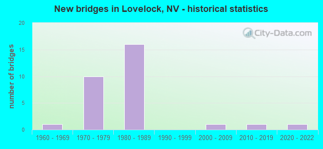
- New bridges - historical statistics
- 11960-1969
- 101970-1979
- 161980-1989
- 12000-2009
- 12010-2019
- 12020-2022


- Bridge Condition - Deck
- 5.3%Very good
- 84.2%Good
- 10.5%Satisfactory

- Bridge Condition - Superstructure
- 15.8%Very good
- 47.4%Good
- 31.6%Satisfactory
- 5.3%Fair

- Bridge Condition - Substructure
- 5.3%Very good
- 63.2%Good
- 31.6%Satisfactory

- Bridge Condition - Channel
- 20.0%Very good
- 10.0%Good
- 70.0%Satisfactory

- Bridge Condition - Culverts
- 50.0%Good
- 50.0%Satisfactory
Find on map >> Show street view
Structure Number: B 529, Location: NORTHEAST OF LOVELOCK (Lat: 40.187386, Lng: -118.455889), Route carried "on" structure: State highway 856, Year Built: 1988, Status: Open, Structure Length: 5.49m (18.01ft), Average Daily Traffic: 770 (year 2017), Truck Traffic: 8%, Average Future Daily Traffic: 1,911 (year 2040), Design Load: HS 20+Mod, Features Intersected: HUMBOLDT RVR
Minimum Vertical Clearance: 30+ m (98+ ft), Kilometerpoint: 1.741, Lanes on structure: 2, Owner: State Highway Agency, Approaching Roadway Width: 9.0m (29.5ft), Material/Design: Steel continuous, Design/Construction: Stringer/Multi-beam, Number Of Spans In Main Unit: 2, Length of Maximum Span: 27.1m (88.9ft), Curb or Sidewalk Widths: Left: 0.0m, Right: 1.5m (4.9ft), Curb-To-Curb Width: 11.0m (36.1ft), Out-to-Out Width: 13.7m (44.9ft)
Condition: Deck: Good, Superstructure: Good, Substructure: Good, Channel: Satisfactory, Operating Rating: 51.2 metric tons, Method Used To Determine Operating Rating: Load Factor (LF), Inventory Rating: 30.7 metric tons, Method Used To Determine Inventory Rating: Load Factor (LF), Structural Evaluation: Better than present minimum criteria, Deck Geometry: Better than present minimum criteria, Waterway Adequacy: Superior to present desirable criteria, Approach Roadway Alignment: Equal to present desirable criteria, Designated Inspection Frequency: Every 24 months, Inspection Date: June 2021, Deck Structure Type: Concrete Cast-file-Place, Wearing Surface/Protective System: Wearing Surface: Monolithic Concrete, Deck Protection: Epoxy Coated Reinforcing
Find on map >> Show street view
Structure Number: B 825, Location: EAST OF LOVELOCK (Lat: 40.308575, Lng: -118.339897), Route carried "on" structure: Interstate 80, Year Built: 1961, Year Reconstructed: 1975, Status: Open, Structure Length: 0.82m (2.69ft), Average Daily Traffic: 9,300 (year 2017), Truck Traffic: 40%, Average Future Daily Traffic: 23,082 (year 2040), Design Load: HS 20, Features Intersected: TOREY WASH
Minimum Vertical Clearance: 30+ m (98+ ft), Kilometerpoint: 189.890, Lanes on structure: 4, Base Highway Network: Yes, Owner: State Highway Agency, Approaching Roadway Width: 11.6m (38.1ft), Material/Design: Concrete, Design/Construction: Culvert, Number Of Spans In Main Unit: 2, Length of Maximum Span: 3.7m (12.1ft)
Condition: Channel: Satisfactory, Culverts: Satisfactory, Operating Rating: 59.0 metric tons, Method Used To Determine Operating Rating: Load Factor (LF), Inventory Rating: 35.6 metric tons, Method Used To Determine Inventory Rating: Load Factor (LF), Structural Evaluation: Equal to present minimum criteria, Waterway Adequacy: Equal to present desirable criteria, Approach Roadway Alignment: Equal to present desirable criteria, Designated Inspection Frequency: Every 48 months, Inspection Date: April 2021
Find on map >> Show street view
Structure Number: B 855E, Location: EAST OF LOVELOCK (Lat: 40.190853, Lng: -118.456506), Route carried "on" structure: Interstate 80, Year Built: 1976, Status: Open, Structure Length: 7.89m (25.89ft), Average Daily Traffic: 4,550 (year 2017), Truck Traffic: 35%, Average Future Daily Traffic: 11,293 (year 2040), Design Load: HS 20+Mod, Features Intersected: HUMBOLDT RVR, GLENN LN
Minimum Vertical Clearance: 30+ m (98+ ft), Kilometerpoint: 173.120, Lanes on structure: 2, Lanes under structure: 2, Base Highway Network: Yes, Owner: State Highway Agency, Approaching Roadway Width: 11.6m (38.1ft), Skew: 2 degrees, Material/Design: Steel, Design/Construction: Stringer/Multi-beam, Number Of Spans In Main Unit: 3, Length of Maximum Span: 26.2m (86.0ft), Curb-To-Curb Width: 12.8m (42.0ft), Out-to-Out Width: 13.7m (44.9ft)
Condition: Deck: Good, Superstructure: Good, Substructure: Good, Channel: Satisfactory, Operating Rating: 60.3 metric tons, Method Used To Determine Operating Rating: Load Factor (LF), Inventory Rating: 31.9 metric tons, Method Used To Determine Inventory Rating: Load Factor (LF), Structural Evaluation: Better than present minimum criteria, Deck Geometry: Equal to present desirable criteria, Underclear: High priority of corrective action, Waterway Adequacy: Superior to present desirable criteria, Approach Roadway Alignment: Equal to present desirable criteria, Designated Inspection Frequency: Every 24 months, Underwater Inspection Frequency: Every 48 months, Inspection Date: June 2021, Underwater Inspection Date: July 2019, Deck Structure Type: Concrete Cast-file-Place, Wearing Surface/Protective System: Wearing Surface: Latex Concrete
Find on map >> Show street view
Structure Number: B 855W, Location: EAST OF LOVELOCK (Lat: 40.191033, Lng: -118.456694), Route carried "on" structure: Interstate 80, Year Built: 1976, Status: Open, Structure Length: 7.96m (26.12ft), Average Daily Traffic: 4,550 (year 2017), Truck Traffic: 35%, Average Future Daily Traffic: 11,293 (year 2040), Design Load: HS 20+Mod, Features Intersected: HUMBOLDT RVR
Minimum Vertical Clearance: 30+ m (98+ ft), Kilometerpoint: 173.120, Lanes on structure: 2, Lanes under structure: 2, Base Highway Network: Yes, Owner: State Highway Agency, Approaching Roadway Width: 11.6m (38.1ft), Skew: 2 degrees, Material/Design: Steel, Design/Construction: Stringer/Multi-beam, Number Of Spans In Main Unit: 3, Length of Maximum Span: 26.2m (86.0ft), Curb or Sidewalk Widths: Left: 0.3m (1.0ft), Right: 0.3m (1.0ft), Curb-To-Curb Width: 12.8m (42.0ft), Out-to-Out Width: 13.7m (44.9ft)
Condition: Deck: Good, Superstructure: Good, Substructure: Good, Channel: Satisfactory, Operating Rating: 60.3 metric tons, Method Used To Determine Operating Rating: Load Factor (LF), Inventory Rating: 31.9 metric tons, Method Used To Determine Inventory Rating: Load Factor (LF), Structural Evaluation: Better than present minimum criteria, Deck Geometry: Equal to present desirable criteria, Underclear: High priority of corrective action, Waterway Adequacy: Superior to present desirable criteria, Approach Roadway Alignment: Equal to present desirable criteria, Designated Inspection Frequency: Every 24 months, Underwater Inspection Frequency: Every 48 months, Inspection Date: June 2021, Underwater Inspection Date: July 2019, Deck Structure Type: Concrete Cast-file-Place, Wearing Surface/Protective System: Wearing Surface: Latex Concrete
Find on map >> Show street view
Structure Number: B1161E, Location: EAST OF LOVELOCK (Lat: 40.193308, Lng: -118.448103), Route carried "on" structure: Interstate 80, Year Built: 1976, Status: Open, Structure Length: 2.23m (7.32ft), Average Daily Traffic: 4,550 (year 2017), Truck Traffic: 35%, Average Future Daily Traffic: 11,293 (year 2040), Design Load: HS 20+Mod, Features Intersected: ROGERS CANAL
Minimum Vertical Clearance: 30+ m (98+ ft), Kilometerpoint: 173.845, Lanes on structure: 2, Base Highway Network: Yes, Owner: State Highway Agency, Approaching Roadway Width: 11.6m (38.1ft), Skew: 3 degrees, Material/Design: Steel, Design/Construction: Stringer/Multi-beam, Number Of Spans In Main Unit: 1, Length of Maximum Span: 20.7m (67.9ft), Curb-To-Curb Width: 12.8m (42.0ft), Out-to-Out Width: 13.7m (44.9ft)
Condition: Deck: Good, Superstructure: Good, Substructure: Satisfactory, Channel: Satisfactory, Operating Rating: 70.5 metric tons, Method Used To Determine Operating Rating: Load Factor (LF), Inventory Rating: 42.4 metric tons, Method Used To Determine Inventory Rating: Load Factor (LF), Structural Evaluation: Equal to present minimum criteria, Deck Geometry: Equal to present desirable criteria, Waterway Adequacy: Equal to present desirable criteria, Approach Roadway Alignment: Equal to present desirable criteria, Length Of Structure Improvement: 3.04m (9.97ft), Designated Inspection Frequency: Every 24 months, Inspection Date: June 2021, Bridge Improvement Cost: $342,000, Roadway Improvement Cost: $34,000, Total Project Cost: $512,000, Deck Structure Type: Concrete Cast-file-Place, Wearing Surface/Protective System: Wearing Surface: Other
Find on map >> Show street view
Structure Number: B1161W, Location: EAST OF LOVELOCK (Lat: 40.193567, Lng: -118.448092), Route carried "on" structure: Interstate 80, Year Built: 1976, Status: Open, Structure Length: 2.23m (7.32ft), Average Daily Traffic: 4,550 (year 2017), Truck Traffic: 35%, Average Future Daily Traffic: 11,293 (year 2040), Design Load: HS 20+Mod, Features Intersected: ROGERS CANAL
Minimum Vertical Clearance: 30+ m (98+ ft), Kilometerpoint: 173.845, Lanes on structure: 2, Base Highway Network: Yes, Owner: State Highway Agency, Approaching Roadway Width: 11.6m (38.1ft), Skew: 3 degrees, Material/Design: Steel, Design/Construction: Stringer/Multi-beam, Number Of Spans In Main Unit: 1, Length of Maximum Span: 20.7m (67.9ft), Curb-To-Curb Width: 12.8m (42.0ft), Out-to-Out Width: 13.7m (44.9ft)
Condition: Deck: Good, Superstructure: Good, Substructure: Satisfactory, Channel: Satisfactory, Operating Rating: 70.5 metric tons, Method Used To Determine Operating Rating: Load Factor (LF), Inventory Rating: 42.4 metric tons, Method Used To Determine Inventory Rating: Load Factor (LF), Structural Evaluation: Equal to present minimum criteria, Deck Geometry: Equal to present desirable criteria, Waterway Adequacy: Equal to present desirable criteria, Approach Roadway Alignment: Equal to present desirable criteria, Designated Inspection Frequency: Every 24 months, Inspection Date: June 2021, Deck Structure Type: Concrete Cast-file-Place, Wearing Surface/Protective System: Wearing Surface: Other
Find on map >> Show street view
Structure Number: B1508, Location: NORTHEAST OF LOVELOCK (Lat: 40.216478, Lng: -118.425636), Route carried "on" structure: Other road , Year Built: 1986, Status: Open, Structure Length: 4.33m (14.21ft), Average Daily Traffic: 350 (year 2017), Truck Traffic: 3%, Average Future Daily Traffic: 869 (year 2040), Design Load: HS 20, Features Intersected: HUMBOLDT RVR, Facility Carried by Structure: IRISH AMERICAN RD
Minimum Vertical Clearance: 30+ m (98+ ft), Kilometerpoint: 0.000, Lanes on structure: 2, Owner: County Highway Agency, Approaching Roadway Width: 8.5m (27.9ft), Skew: 3 degrees, Material/Design: Prestressed concrete, Design/Construction: Box Beam or Girders - Multiple, Number Of Spans In Main Unit: 2, Length of Maximum Span: 21.3m (69.9ft), Curb-To-Curb Width: 8.5m (27.9ft), Out-to-Out Width: 9.8m (32.2ft)
Condition: Deck: Good, Superstructure: Good, Substructure: Good, Channel: Good, Operating Rating: 56.1 metric tons, Method Used To Determine Operating Rating: Load Factor (LF), Inventory Rating: 33.6 metric tons, Method Used To Determine Inventory Rating: Load Factor (LF), Structural Evaluation: Better than present minimum criteria, Deck Geometry: Equal to present minimum criteria, Waterway Adequacy: Equal to present desirable criteria, Approach Roadway Alignment: Equal to present desirable criteria, Designated Inspection Frequency: Every 24 months, Inspection Date: May 2021, Deck Structure Type: Concrete Cast-file-Place, Wearing Surface/Protective System: Wearing Surface: Bituminous, Deck Protection: Epoxy Coated Reinforcing
Find on map >> Show street view
Structure Number: B1618, Location: SOUTH OF LOVELOCK (Lat: 40.051975, Lng: -118.467750), Route carried "on" structure: County highway , Year Built: 2002, Status: Open, Structure Length: 2.74m (8.99ft), Average Daily Traffic: 61 (year 2017), Average Future Daily Traffic: 151 (year 2040), Design Load: HS 20+Mod, Features Intersected: HUMBOLDT RVR, Facility Carried by Structure: DERBY RD
Minimum Vertical Clearance: 30+ m (98+ ft), Kilometerpoint: 0.000, Lanes on structure: 2, Owner: County Highway Agency, Approaching Roadway Width: 6.4m (21.0ft), Skew: 2 degrees, Material/Design: Concrete continuous, Design/Construction: Slab, Number Of Spans In Main Unit: 3, Length of Maximum Span: 10.7m (35.1ft), Curb-To-Curb Width: 6.4m (21.0ft), Out-to-Out Width: 7.4m (24.3ft)
Condition: Deck: Good, Superstructure: Good, Substructure: Satisfactory, Channel: Satisfactory, Operating Rating: 62.3 metric tons, Method Used To Determine Operating Rating: Load Factor (LF), Inventory Rating: 37.6 metric tons, Method Used To Determine Inventory Rating: Load Factor (LF), Structural Evaluation: Equal to present minimum criteria, Deck Geometry: Somewhat better than minimum adequacy, Waterway Adequacy: Equal to present desirable criteria, Approach Roadway Alignment: Equal to present desirable criteria, Length Of Structure Improvement: 2.65m (8.69ft), Designated Inspection Frequency: Every 48 months, Inspection Date: May 2021, Bridge Improvement Cost: $210,000, Roadway Improvement Cost: $21,000, Total Project Cost: $315,000, Deck Structure Type: Concrete Cast-file-Place, Wearing Surface/Protective System: Wearing Surface: Epoxy Overlay, Deck Protection: Epoxy Coated Reinforcing
Find on map >> Show street view
Structure Number: B3246, Location: NORTH OF LOVELOCK (Lat: 40.226797, Lng: -118.422444), Route carried "on" structure: Business State highway 396, Year Built: 2021, Status: Open, Structure Length: 4.45m (14.60ft), Average Daily Traffic: 400 (year 2020), Average Future Daily Traffic: 440 (year 2040), Design Load: HL 93, Features Intersected: HUMBOLDT RVR
Minimum Vertical Clearance: 30+ m (98+ ft), Kilometerpoint: 8.443, Lanes on structure: 2, Owner: State Highway Agency, Approaching Roadway Width: 13.7m (44.9ft), Material/Design: Steel continuous, Design/Construction: Box Beam or Girders - Multiple, Number Of Spans In Main Unit: 2, Length of Maximum Span: 21.6m (70.9ft), Curb-To-Curb Width: 12.8m (42.0ft), Out-to-Out Width: 13.7m (44.9ft)
Condition: Deck: Very good, Superstructure: Very good, Substructure: Very good, Channel: Very good, Structural Evaluation: Equal to present desirable criteria, Deck Geometry: Superior to present desirable criteria, Waterway Adequacy: Equal to present desirable criteria, Approach Roadway Alignment: Equal to present desirable criteria, Designated Inspection Frequency: Every 24 months, Inspection Date: July 2021, Deck Structure Type: Concrete Cast-file-Place, Wearing Surface/Protective System: Wearing Surface: Monolithic Concrete
Find on map >> Show street view
Structure Number: B3260E, Location: EAST OF LOVELOCK (Lat: 40.217481, Lng: -118.412297), Route carried "on" structure: Interstate 80, Year Built: 2019, Status: Open, Structure Length: 0.79m (2.59ft), Average Daily Traffic: 9,450 (year 2018), Truck Traffic: 6%, Average Future Daily Traffic: 10,395 (year 2038), Design Load: HL 93, Features Intersected: FAIRVIEW DITCH
Minimum Vertical Clearance: 30+ m (98+ ft), Kilometerpoint: 178.005, Lanes on structure: 2, Base Highway Network: Yes, Owner: State Highway Agency, Approaching Roadway Width: 11.6m (38.1ft), Material/Design: Concrete, Design/Construction: Culvert, Number Of Spans In Main Unit: 3, Length of Maximum Span: 2.4m (7.9ft), Curb-To-Curb Width: 11.6m (38.1ft), Out-to-Out Width: 26.2m (86.0ft)
Condition: Channel: Very good, Culverts: Good, Operating Rating: 48.6 metric tons, Method Used To Determine Operating Rating: Load and Resistance Factor (LRFR), Inventory Rating: 37.6 metric tons, Method Used To Determine Inventory Rating: Load and Resistance Factor (LRFR), Structural Evaluation: Better than present minimum criteria, Deck Geometry: Equal to present minimum criteria, Waterway Adequacy: Equal to present desirable criteria, Approach Roadway Alignment: Equal to present desirable criteria, Designated Inspection Frequency: Every 24 months, Inspection Date: April 2021
Find on map >> Show street view
Structure Number: G 851E, Location: WEST LOVELOCK (Lat: 40.170575, Lng: -118.478858), Route carried "on" structure: Interstate 80, Year Built: 1983, Status: Open, Structure Length: 78.76m (258.40ft), Average Daily Traffic: 4,250 (year 2017), Truck Traffic: 40%, Average Future Daily Traffic: 10,548 (year 2040), Design Load: HS 20+Mod, Features Intersected: SR 396, SR 397 & SPRR
Minimum Vertical Clearance: 30+ m (98+ ft), Kilometerpoint: 169.258, Lanes on structure: 2, Lanes under structure: 6, Base Highway Network: Yes, Owner: State Highway Agency, Approaching Roadway Width: 11.6m (38.1ft), Skew: 9 degrees, Material/Design: Steel, Design/Construction: Stringer/Multi-beam, Number Of Spans In Main Unit: 16, Length of Maximum Span: 59.7m (195.9ft), Curb-To-Curb Width: 12.8m (42.0ft), Out-to-Out Width: 13.7m (44.9ft)
Condition: Deck: Good, Superstructure: Satisfactory, Substructure: Satisfactory, Operating Rating: 32.9 metric tons, Method Used To Determine Operating Rating: Load Factor (LF), Inventory Rating: 19.6 metric tons, Method Used To Determine Inventory Rating: Load Factor (LF), Structural Evaluation: Meets minimum limits, Deck Geometry: Equal to present desirable criteria, Underclear: Better than present minimum criteria, Approach Roadway Alignment: Equal to present desirable criteria, Length Of Structure Improvement: 78.76m (258.40ft), Designated Inspection Frequency: Every 24 months, Other Special Inspection Frequency: Every 24 months, Inspection Date: June 2021, Other Special Inspection Date: June 2021, Bridge Improvement Cost: $8,848,000, Roadway Improvement Cost: $885,000, Total Project Cost: $13,272,000, Deck Structure Type: Concrete Cast-file-Place, Wearing Surface/Protective System: Wearing Surface: Epoxy Overlay, Deck Protection: Epoxy Coated Reinforcing
Find on map >> Show street view
Structure Number: G 851W, Location: WEST LOVELOCK (Lat: 40.170394, Lng: -118.479675), Route carried "on" structure: Interstate 80, Year Built: 1983, Status: Open, Structure Length: 70.65m (231.79ft), Average Daily Traffic: 4,250 (year 2017), Truck Traffic: 40%, Average Future Daily Traffic: 10,548 (year 2040), Design Load: HS 20+Mod, Features Intersected: SR 396, SR 397 & SPRR
Minimum Vertical Clearance: 30+ m (98+ ft), Kilometerpoint: 169.258, Lanes on structure: 2, Lanes under structure: 6, Base Highway Network: Yes, Owner: State Highway Agency, Approaching Roadway Width: 11.6m (38.1ft), Skew: 9 degrees, Material/Design: Steel, Design/Construction: Stringer/Multi-beam, Number Of Spans In Main Unit: 16, Length of Maximum Span: 58.2m (190.9ft), Curb-To-Curb Width: 12.8m (42.0ft), Out-to-Out Width: 13.7m (44.9ft)
Condition: Deck: Good, Superstructure: Fair, Substructure: Good, Operating Rating: 38.2 metric tons, Method Used To Determine Operating Rating: Load Factor (LF), Inventory Rating: 22.9 metric tons, Method Used To Determine Inventory Rating: Load Factor (LF), Structural Evaluation: Somewhat better than minimum adequacy, Deck Geometry: Equal to present desirable criteria, Underclear: Better than present minimum criteria, Approach Roadway Alignment: Equal to present desirable criteria, Length Of Structure Improvement: 72.24m (237.01ft), Designated Inspection Frequency: Every 12 months, Other Special Inspection Frequency: Every 24 months, Inspection Date: June 2021, Other Special Inspection Date: June 2020, Bridge Improvement Cost: $7,998,000, Roadway Improvement Cost: $800,000, Total Project Cost: $11,997,000, Deck Structure Type: Concrete Cast-file-Place, Wearing Surface/Protective System: Wearing Surface: Epoxy Overlay, Deck Protection: Epoxy Coated Reinforcing
Find on map >> Show street view
Structure Number: G1346, Location: LOVELOCK (Lat: 40.189372, Lng: -118.466286), Route carried "on" structure: State highway 856, Year Built: 1981, Status: Open, Structure Length: 25.60m (83.99ft), Average Daily Traffic: 1,300 (year 2017), Truck Traffic: 7%, Average Future Daily Traffic: 3,226 (year 2040), Design Load: HS 20+Mod, Features Intersected: SR 396 & SPRR
Minimum Vertical Clearance: 30+ m (98+ ft), Kilometerpoint: 2.770, Lanes on structure: 2, Lanes under structure: 2, Owner: State Highway Agency, Approaching Roadway Width: 9.8m (32.2ft), Material/Design: Steel, Design/Construction: Stringer/Multi-beam, Number Of Spans In Main Unit: 8, Length of Maximum Span: 33.5m (109.9ft), Curb or Sidewalk Widths: Left: 1.5m (4.9ft), Right: 0.0m, Curb-To-Curb Width: 11.0m (36.1ft), Out-to-Out Width: 13.7m (44.9ft)
Condition: Deck: Good, Superstructure: Satisfactory, Substructure: Satisfactory, Operating Rating: 33.6 metric tons, Method Used To Determine Operating Rating: Load Factor (LF), Inventory Rating: 20.1 metric tons, Method Used To Determine Inventory Rating: Load Factor (LF), Structural Evaluation: Somewhat better than minimum adequacy, Deck Geometry: Equal to present minimum criteria, Underclear: Meets minimum limits, Approach Roadway Alignment: Equal to present minimum criteria, Designated Inspection Frequency: Every 24 months, Inspection Date: June 2021, Deck Structure Type: Concrete Cast-file-Place, Wearing Surface/Protective System: Wearing Surface: Monolithic Concrete, Deck Protection: Epoxy Coated Reinforcing
Find on map >> Show street view
Structure Number: H 849E, Location: WEST OF LOVELOCK (Lat: 40.130975, Lng: -118.517761), Route carried "on" structure: Interstate 80, Year Built: 1971, Status: Open, Structure Length: 2.87m (9.42ft), Average Daily Traffic: 4,450 (year 2017), Truck Traffic: 35%, Average Future Daily Traffic: 11,044 (year 2040), Design Load: HS 20+Mod, Features Intersected: CROSS ROAD
Minimum Vertical Clearance: 30+ m (98+ ft), Kilometerpoint: 164.042, Lanes on structure: 2, Lanes under structure: 2, Base Highway Network: Yes, Owner: State Highway Agency, Approaching Roadway Width: 12.9m (42.3ft), Material/Design: Concrete continuous, Design/Construction: Slab, Number Of Spans In Main Unit: 3, Length of Maximum Span: 10.7m (35.1ft), Curb-To-Curb Width: 12.9m (42.3ft), Out-to-Out Width: 13.5m (44.3ft)
Condition: Deck: Satisfactory, Superstructure: Satisfactory, Substructure: Good, Operating Rating: 61.3 metric tons, Method Used To Determine Operating Rating: Load Factor (LF), Inventory Rating: 36.8 metric tons, Method Used To Determine Inventory Rating: Load Factor (LF), Structural Evaluation: Equal to present minimum criteria, Deck Geometry: Superior to present desirable criteria, Underclear: Meets minimum limits, Approach Roadway Alignment: Equal to present desirable criteria, Designated Inspection Frequency: Every 48 months, Inspection Date: May 2021, Deck Structure Type: Concrete Cast-file-Place, Wearing Surface/Protective System: Wearing Surface: Bituminous
Find on map >> Show street view
Structure Number: H 849W, Location: WEST OF LOVELOCK (Lat: 40.131256, Lng: -118.518128), Route carried "on" structure: Interstate 80, Year Built: 1971, Status: Open, Structure Length: 2.87m (9.42ft), Average Daily Traffic: 4,450 (year 2017), Truck Traffic: 35%, Average Future Daily Traffic: 11,044 (year 2040), Design Load: HS 20+Mod, Features Intersected: CROSS ROAD
Minimum Vertical Clearance: 30+ m (98+ ft), Kilometerpoint: 164.042, Lanes on structure: 2, Lanes under structure: 2, Base Highway Network: Yes, Owner: State Highway Agency, Approaching Roadway Width: 12.4m (40.7ft), Material/Design: Concrete continuous, Design/Construction: Slab, Number Of Spans In Main Unit: 3, Length of Maximum Span: 10.7m (35.1ft), Curb-To-Curb Width: 12.4m (40.7ft), Out-to-Out Width: 13.5m (44.3ft)
Condition: Deck: Satisfactory, Superstructure: Satisfactory, Substructure: Good, Operating Rating: 61.3 metric tons, Method Used To Determine Operating Rating: Load Factor (LF), Inventory Rating: 36.8 metric tons, Method Used To Determine Inventory Rating: Load Factor (LF), Structural Evaluation: Equal to present minimum criteria, Deck Geometry: Better than present minimum criteria, Underclear: Meets minimum limits, Approach Roadway Alignment: Equal to present desirable criteria, Designated Inspection Frequency: Every 48 months, Inspection Date: May 2021, Deck Structure Type: Concrete Cast-file-Place, Wearing Surface/Protective System: Wearing Surface: Bituminous
Find on map >> Show street view
Structure Number: H 850E, Location: WEST OF LOVELOCK (Lat: 40.158242, Lng: -118.490344), Route carried "on" structure: Interstate 80, Year Built: 1974, Status: Open, Structure Length: 1.34m (4.40ft), Average Daily Traffic: 4,450 (year 2017), Truck Traffic: 35%, Average Future Daily Traffic: 11,044 (year 2040), Design Load: HS 20+Mod, Features Intersected: WESTFALL ROAD
Minimum Vertical Clearance: 30+ m (98+ ft), Kilometerpoint: 167.908, Lanes on structure: 2, Lanes under structure: 2, Base Highway Network: Yes, Owner: State Highway Agency, Approaching Roadway Width: 12.7m (41.7ft), Skew: 2 degrees, Material/Design: Prestressed concrete, Design/Construction: Box Beam or Girders - Multiple, Number Of Spans In Main Unit: 1, Length of Maximum Span: 12.8m (42.0ft), Curb-To-Curb Width: 12.9m (42.3ft), Out-to-Out Width: 13.7m (44.9ft)
Condition: Deck: Good, Superstructure: Good, Substructure: Good, Operating Rating: 58.4 metric tons, Method Used To Determine Operating Rating: Load Factor (LF), Inventory Rating: 34.9 metric tons, Method Used To Determine Inventory Rating: Load Factor (LF), Structural Evaluation: Better than present minimum criteria, Deck Geometry: Superior to present desirable criteria, Underclear: Meets minimum limits, Approach Roadway Alignment: Equal to present desirable criteria, Designated Inspection Frequency: Every 48 months, Inspection Date: May 2021, Deck Structure Type: Concrete Cast-file-Place, Wearing Surface/Protective System: Wearing Surface: Bituminous
Find on map >> Show street view
Structure Number: H 850W, Location: WEST OF LOVELOCK (Lat: 40.158247, Lng: -118.490761), Route carried "on" structure: Interstate 80, Year Built: 1974, Status: Open, Structure Length: 1.35m (4.43ft), Average Daily Traffic: 4,450 (year 2017), Truck Traffic: 35%, Average Future Daily Traffic: 11,044 (year 2040), Design Load: HS 20+Mod, Features Intersected: CROSS ROAD
Minimum Vertical Clearance: 30+ m (98+ ft), Kilometerpoint: 167.908, Lanes on structure: 2, Lanes under structure: 2, Base Highway Network: Yes, Owner: State Highway Agency, Approaching Roadway Width: 12.8m (42.0ft), Skew: 2 degrees, Material/Design: Prestressed concrete, Design/Construction: Box Beam or Girders - Multiple, Number Of Spans In Main Unit: 1, Length of Maximum Span: 12.6m (41.3ft), Curb-To-Curb Width: 12.8m (42.0ft), Out-to-Out Width: 13.8m (45.3ft)
Condition: Deck: Good, Superstructure: Good, Substructure: Good, Operating Rating: 58.4 metric tons, Method Used To Determine Operating Rating: Load Factor (LF), Inventory Rating: 34.9 metric tons, Method Used To Determine Inventory Rating: Load Factor (LF), Structural Evaluation: Better than present minimum criteria, Deck Geometry: Equal to present desirable criteria, Underclear: Meets minimum limits, Approach Roadway Alignment: Equal to present desirable criteria, Designated Inspection Frequency: Every 48 months, Inspection Date: May 2021, Deck Structure Type: Concrete Cast-file-Place, Wearing Surface/Protective System: Wearing Surface: Bituminous
Find on map >> Show street view
Structure Number: H 856, Location: EAST OF LOVELOCK (Lat: 40.212761, Lng: -118.417472), Route carried "on" structure: County highway , Year Built: 1976, Status: Open, Structure Length: 11.49m (37.70ft), Average Daily Traffic: 300 (year 2017), Truck Traffic: 5%, Average Future Daily Traffic: 745 (year 2040), Design Load: HS 20+Mod, Features Intersected: I 80, Facility Carried by Structure: CROSS ROAD
Minimum Vertical Clearance: 30+ m (98+ ft), Kilometerpoint: 0.000, Lanes on structure: 2, Lanes under structure: 4, Owner: State Highway Agency, Approaching Roadway Width: 9.8m (32.2ft), Skew: 1 degrees, Material/Design: Concrete continuous, Design/Construction: Box Beam or Girders - Single/Spread, Number Of Spans In Main Unit: 5, Length of Maximum Span: 31.1m (102.0ft), Curb-To-Curb Width: 9.8m (32.2ft), Out-to-Out Width: 11.0m (36.1ft)
Condition: Deck: Good, Superstructure: Satisfactory, Substructure: Satisfactory, Operating Rating: 75.0 metric tons, Method Used To Determine Operating Rating: Load Factor (LF), Inventory Rating: 44.6 metric tons, Method Used To Determine Inventory Rating: Load Factor (LF), Structural Evaluation: Equal to present minimum criteria, Deck Geometry: Better than present minimum criteria, Underclear: Better than present minimum criteria, Approach Roadway Alignment: Equal to present desirable criteria, Designated Inspection Frequency: Every 24 months, Inspection Date: June 2021, Deck Structure Type: Concrete Cast-file-Place, Wearing Surface/Protective System: Wearing Surface: Epoxy Overlay, Membrane: Preformed Fabric
Find on map >> Show street view
Structure Number: I 852E, Location: LOVELOCK (Lat: 40.178539, Lng: -118.471069), Route carried "on" structure: Interstate 80, Year Built: 1983, Status: Open, Structure Length: 3.49m (11.45ft), Average Daily Traffic: 4,300 (year 2017), Truck Traffic: 40%, Average Future Daily Traffic: 10,672 (year 2040), Design Load: HS 20+Mod, Features Intersected: SR398 N MERIDIAN RD
Minimum Vertical Clearance: 30+ m (98+ ft), Kilometerpoint: 171.178, Lanes on structure: 2, Lanes under structure: 4, Base Highway Network: Yes, Owner: State Highway Agency, Approaching Roadway Width: 12.4m (40.7ft), Material/Design: Prestressed concrete, Design/Construction: Box Beam or Girders - Multiple, Number Of Spans In Main Unit: 1, Length of Maximum Span: 34.3m (112.5ft), Curb-To-Curb Width: 13.0m (42.7ft), Out-to-Out Width: 14.0m (45.9ft)
Condition: Deck: Good, Superstructure: Very good, Substructure: Good, Structural Evaluation: Better than present minimum criteria, Deck Geometry: Superior to present desirable criteria, Underclear: Meets minimum limits, Approach Roadway Alignment: Equal to present desirable criteria, Designated Inspection Frequency: Every 24 months, Inspection Date: May 2021, Deck Structure Type: Concrete Cast-file-Place, Wearing Surface/Protective System: Wearing Surface: Latex Concrete, Deck Protection: Epoxy Coated Reinforcing
Find on map >> Show street view
Structure Number: I 852W, Location: LOVELOCK (Lat: 40.178589, Lng: -118.471406), Route carried "on" structure: Interstate 80, Year Built: 1983, Status: Open, Structure Length: 3.48m (11.42ft), Average Daily Traffic: 4,300 (year 2017), Truck Traffic: 40%, Average Future Daily Traffic: 10,672 (year 2040), Design Load: HS 20+Mod, Features Intersected: SR398 N MERIDIAN RD
Minimum Vertical Clearance: 30+ m (98+ ft), Kilometerpoint: 171.178, Lanes on structure: 2, Lanes under structure: 4, Base Highway Network: Yes, Owner: State Highway Agency, Approaching Roadway Width: 12.9m (42.3ft), Material/Design: Prestressed concrete, Design/Construction: Box Beam or Girders - Multiple, Number Of Spans In Main Unit: 1, Length of Maximum Span: 33.5m (109.9ft), Curb-To-Curb Width: 12.9m (42.3ft), Out-to-Out Width: 13.7m (44.9ft)
Condition: Deck: Good, Superstructure: Very good, Substructure: Good, Structural Evaluation: Better than present minimum criteria, Deck Geometry: Superior to present desirable criteria, Underclear: Meets minimum limits, Approach Roadway Alignment: Equal to present desirable criteria, Designated Inspection Frequency: Every 24 months, Inspection Date: May 2021, Deck Structure Type: Concrete Cast-file-Place, Wearing Surface/Protective System: Wearing Surface: Latex Concrete, Deck Protection: Epoxy Coated Reinforcing
Find on map >> Show street view
Structure Number: I 854, Location: LOVELOCK (Lat: 40.188297, Lng: -118.463286), Route carried "on" structure: ServiceOther road 856, Year Built: 1981, Status: Open, Structure Length: 8.14m (26.71ft), Average Daily Traffic: 1,500 (year 2017), Truck Traffic: 7%, Average Future Daily Traffic: 3,723 (year 2040), Design Load: HS 20+Mod, Features Intersected: I 80
Minimum Vertical Clearance: 30+ m (98+ ft), Kilometerpoint: 0.000, Lanes on structure: 2, Lanes under structure: 4, Owner: State Highway Agency, Approaching Roadway Width: 10.2m (33.5ft), Skew: 1 degrees, Material/Design: Steel, Design/Construction: Stringer/Multi-beam, Number Of Spans In Main Unit: 2, Length of Maximum Span: 40.8m (133.9ft), Curb or Sidewalk Widths: Left: 0.0m, Right: 1.5m (4.9ft), Curb-To-Curb Width: 11.0m (36.1ft), Out-to-Out Width: 13.7m (44.9ft)
Condition: Deck: Good, Superstructure: Satisfactory, Substructure: Good, Inventory Rating: 64.9 metric tons, Method Used To Determine Inventory Rating: Load Factor (LF), Structural Evaluation: Equal to present minimum criteria, Deck Geometry: Equal to present minimum criteria, Underclear: Somewhat better than minimum adequacy, Approach Roadway Alignment: Equal to present desirable criteria, Length Of Structure Improvement: 9.14m (29.99ft), Designated Inspection Frequency: Every 24 months, Inspection Date: June 2021, Bridge Improvement Cost: $1,027,000, Roadway Improvement Cost: $103,000, Total Project Cost: $1,541,000, Deck Structure Type: Concrete Cast-file-Place, Wearing Surface/Protective System: Wearing Surface: Monolithic Concrete, Deck Protection: Epoxy Coated Reinforcing
Find on map >> Show street view
Structure Number: G 851E, Location: WEST LOVELOCK (Lat: 40.170575, Lng: -118.478858), Route carried "under" structure: State highway 396, Year Built: 1983, Structure Length: 0. m, Average Daily Traffic: 2,700 (year 2009), Truck Traffic: 3%, Features Intersected: SR 396, SR 397 & SPRR, Facility Carried by Structure: I 80E
Minimum Vertical Clearance: 7.10m (23.29ft), Kilometerpoint: 169.258, Lanes on structure: 2, Lanes under structure: 6, Material/Design: Steel, Design/Construction: Stringer/Multi-beam, Length of Maximum Span: 59.7m (195.9ft)
Find on map >> Show street view
Structure Number: G 851E, Location: WEST LOVELOCK (Lat: 40.170575, Lng: -118.478858), Route carried "under" structure: State highway 397, Year Built: 1983, Structure Length: 0. m, Average Daily Traffic: 430 (year 2009), Truck Traffic: 3%, Features Intersected: SR 396, SR 397 & SPRR, Facility Carried by Structure: I 80E
Minimum Vertical Clearance: 4.88m (16.01ft), Kilometerpoint: 169.258, Lanes on structure: 2, Lanes under structure: 6, Material/Design: Steel, Design/Construction: Stringer/Multi-beam, Length of Maximum Span: 59.7m (195.9ft)
Find on map >> Show street view
Structure Number: G 851W, Location: WEST LOVELOCK (Lat: 40.170394, Lng: -118.479675), Route carried "under" structure: State highway 397, Year Built: 1983, Structure Length: 0. m, Average Daily Traffic: 600 (year 2009), Truck Traffic: 3%, Features Intersected: SR 396, SR 397 & SPRR, Facility Carried by Structure: I 80
Minimum Vertical Clearance: 4.88m (16.01ft), Kilometerpoint: 169.258, Lanes on structure: 2, Lanes under structure: 6, Material/Design: Steel, Design/Construction: Stringer/Multi-beam, Length of Maximum Span: 58.2m (190.9ft)
Find on map >> Show street view
Structure Number: G 851W, Location: WEST LOVELOCK (Lat: 40.170394, Lng: -118.479675), Route carried "under" structure: State highway 396, Year Built: 1983, Structure Length: 0. m, Average Daily Traffic: 3,475 (year 2009), Truck Traffic: 3%, Features Intersected: SR 396, SR 397 & SPRR, Facility Carried by Structure: I 80
Minimum Vertical Clearance: 7.16m (23.49ft), Kilometerpoint: 169.258, Lanes on structure: 2, Lanes under structure: 6, Material/Design: Steel, Design/Construction: Stringer/Multi-beam, Length of Maximum Span: 58.2m (190.9ft)
Find on map >> Show street view
Structure Number: G1346, Location: LOVELOCK (Lat: 40.189372, Lng: -118.466286), Route carried "under" structure: State highway 396, Year Built: 1981, Structure Length: 0. m, Average Daily Traffic: 1,745 (year 2009), Truck Traffic: 3%, Features Intersected: SR 396 & SPRR, Facility Carried by Structure: SR 856
Minimum Vertical Clearance: 6.37m (20.90ft), Kilometerpoint: 2.770, Lanes on structure: 2, Lanes under structure: 2, Material/Design: Steel, Design/Construction: Stringer/Multi-beam, Length of Maximum Span: 33.5m (109.9ft)
Find on map >> Show street view
Structure Number: H 856, Location: EAST OF LOVELOCK (Lat: 40.212761, Lng: -118.417472), Route carried "under" structure: Interstate 80, Year Built: 1976, Structure Length: 0. m, Average Daily Traffic: 7,850 (year 2009), Truck Traffic: 4%, Features Intersected: I 80, Facility Carried by Structure: CROSS ROAD
Minimum Vertical Clearance: 5.21m (17.09ft), Kilometerpoint: 0.000, Lanes on structure: 2, Lanes under structure: 4, Material/Design: Concrete continuous, Design/Construction: Box Beam or Girders - Single/Spread, Length of Maximum Span: 31.1m (102.0ft)
Find on map >> Show street view
Structure Number: I 852E, Location: LOVELOCK (Lat: 40.178539, Lng: -118.471069), Route carried "under" structure: State highway 398, Year Built: 1983, Structure Length: 0. m, Average Daily Traffic: 2,090 (year 2009), Truck Traffic: 5%, Features Intersected: SR398 N MERIDIAN RD, Facility Carried by Structure: I 80E
Minimum Vertical Clearance: 5.12m (16.80ft), Kilometerpoint: 171.178, Lanes on structure: 2, Lanes under structure: 4, Material/Design: Prestressed concrete, Design/Construction: Box Beam or Girders - Multiple, Length of Maximum Span: 34.3m (112.5ft)
Find on map >> Show street view
Structure Number: I 852W, Location: LOVELOCK (Lat: 40.178589, Lng: -118.471406), Route carried "under" structure: State highway 398, Year Built: 1983, Structure Length: 0. m, Average Daily Traffic: 2,090 (year 2009), Truck Traffic: 5%, Features Intersected: SR398 N MERIDIAN RD, Facility Carried by Structure: I 80W
Minimum Vertical Clearance: 5.12m (16.80ft), Kilometerpoint: 171.178, Lanes on structure: 2, Lanes under structure: 4, Material/Design: Prestressed concrete, Design/Construction: Box Beam or Girders - Multiple, Length of Maximum Span: 33.5m (109.9ft)
Find on map >> Show street view
Structure Number: I 854, Location: LOVELOCK (Lat: 40.188297, Lng: -118.463286), Route carried "under" structure: Interstate 80, Year Built: 1981, Structure Length: 0. m, Average Daily Traffic: 7,260 (year 2009), Truck Traffic: 10%, Features Intersected: I 80, Facility Carried by Structure: SR856 AIRPORT RD
Minimum Vertical Clearance: 5.09m (16.70ft), Kilometerpoint: 0.000, Lanes on structure: 2, Lanes under structure: 4, Material/Design: Steel, Design/Construction: Stringer/Multi-beam, Length of Maximum Span: 40.8m (133.9ft)