Bridge Statistics for Low Moor, Virginia (VA)
Condition, Traffic, Stress, Structural Evaluation, Project Costs
- National Bridge Inventory (NBI) Statistics
- 12Number of bridges
- 157ft / 48.3mTotal length
- $170,000Total costs
- 41,749Total average daily traffic
- 5,092Total average daily truck traffic
- National Bridge Inventory (NBI) Registered Bridges for Low Moor
- No street view available for this location
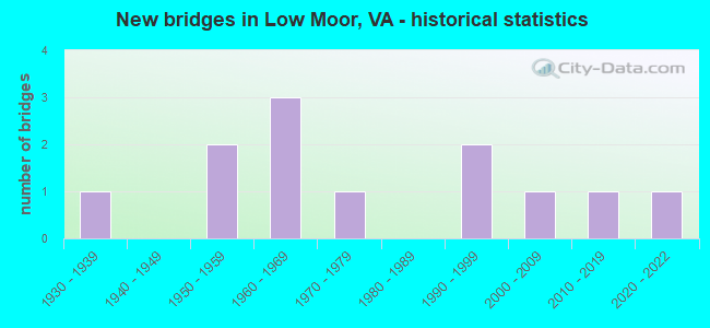
- New bridges - historical statistics
- 11930-1939
- 21950-1959
- 31960-1969
- 11970-1979
- 21990-1999
- 12000-2009
- 12010-2019
- 12020-2022


- Bridge Condition - Deck
- 14.3%Excellent
- 57.1%Good
- 14.3%Satisfactory
- 14.3%Fair

- Bridge Condition - Superstructure
- 14.3%Excellent
- 42.9%Good
- 14.3%Satisfactory
- 28.6%Fair

- Bridge Condition - Substructure
- 14.3%Excellent
- 42.9%Good
- 28.6%Satisfactory
- 14.3%Fair

- Bridge Condition - Channel
- 10.0%Excellent
- 30.0%Very good
- 20.0%Good
- 30.0%Satisfactory
- 10.0%Fair

- Bridge Condition - Culverts
- 50.0%Good
- 50.0%Fair
Find on map >> Show street view
Structure Number: 997, Location: 2.58TO 220E & 4.83TO 220W (Lat: 37.790447, Lng: -79.889592), Route carried "on" structure: Interstate 64, Year Built: 1954, Status: Open, Structure Length: 3.05m (10.01ft), Average Daily Traffic: 8,752 (year 2020), Truck Traffic: 24%, Average Future Daily Traffic: 12,253 (year 2040), Design Load: HS 20, Features Intersected: KARNES CREEK
Minimum Vertical Clearance: 30+ m (98+ ft), Kilometerpoint: 34.417, Lanes on structure: 3, Base Highway Network: Yes, Owner: State Highway Agency, Approaching Roadway Width: 14.6m (47.9ft), Material/Design: Steel continuous, Design/Construction: Stringer/Multi-beam, Number Of Spans In Main Unit: 3, Length of Maximum Span: 10.4m (34.1ft), Curb-To-Curb Width: 17.0m (55.8ft), Out-to-Out Width: 17.9m (58.7ft)
Condition: Deck: Good, Superstructure: Satisfactory, Substructure: Satisfactory, Channel: Very good, Operating Rating: 89.8 metric tons, Method Used To Determine Operating Rating: Load and Resistance Factor (LRFR), Inventory Rating: 75.3 metric tons, Method Used To Determine Inventory Rating: Load and Resistance Factor (LRFR), Structural Evaluation: Equal to present minimum criteria, Deck Geometry: Equal to present minimum criteria, Waterway Adequacy: Better than present minimum criteria, Approach Roadway Alignment: Equal to present desirable criteria, Designated Inspection Frequency: Every 24 months, Inspection Date: October 2021, Deck Structure Type: Concrete Cast-file-Place, Wearing Surface/Protective System: Deck Protection: Epoxy Coated Reinforcing
Find on map >> Show street view
Structure Number: 1125, Location: 1.55 TO 623 & 1.45 TO 622 (Lat: 37.757086, Lng: -79.913914), Route carried "on" structure: County highway 616, Year Built: 1952, Status: Open, Structure Length: 1.34m (4.40ft), Average Daily Traffic: 631 (year 2020), Truck Traffic: 17%, Average Future Daily Traffic: 726 (year 2040), Design Load: HS 20, Features Intersected: KARNES CREEK, Facility Carried by Structure: RICH PATCH ROAD
Minimum Vertical Clearance: 30+ m (98+ ft), Kilometerpoint: 26.552, Lanes on structure: 2, Owner: State Highway Agency, Approaching Roadway Width: 5.5m (18.0ft), Skew: 4 degrees, Material/Design: Concrete, Design/Construction: Culvert, Number Of Spans In Main Unit: 3, Length of Maximum Span: 3.0m (9.8ft)
Condition: Channel: Satisfactory, Culverts: Fair, Operating Rating: 54.4 metric tons, Method Used To Determine Operating Rating: Field evaluation and documented engineering judgment, Inventory Rating: 32.7 metric tons, Method Used To Determine Inventory Rating: Field evaluation and documented engineering judgment, Structural Evaluation: Somewhat better than minimum adequacy, Waterway Adequacy: Better than present minimum criteria, Approach Roadway Alignment: Better than present minimum criteria, Designated Inspection Frequency: Every 12 months, Inspection Date: May 2021
Find on map >> Show street view
Structure Number: 1129, Location: .06 TO 623 & 1.38 TO 1308 (Lat: 37.772569, Lng: -79.894617), Route carried "on" structure: County highway 616, Year Built: 1932, Status: Open, Structure Length: 1.09m (3.58ft), Average Daily Traffic: 808 (year 2020), Truck Traffic: 17%, Average Future Daily Traffic: 889 (year 2040), Design Load: HS 20, Features Intersected: WHITE ROCK CREEK, Facility Carried by Structure: RICH PATCH ROAD
Minimum Vertical Clearance: 30+ m (98+ ft), Kilometerpoint: 29.145, Lanes on structure: 2, Owner: State Highway Agency, Approaching Roadway Width: 5.8m (19.0ft), Skew: 3 degrees, Material/Design: Concrete, Design/Construction: Culvert, Number Of Spans In Main Unit: 3, Length of Maximum Span: 3.0m (9.8ft)
Condition: Channel: Fair, Culverts: Fair, Operating Rating: 52.6 metric tons, Method Used To Determine Operating Rating: Field evaluation and documented engineering judgment, Inventory Rating: 30.8 metric tons, Method Used To Determine Inventory Rating: Field evaluation and documented engineering judgment, Structural Evaluation: Somewhat better than minimum adequacy, Waterway Adequacy: Better than present minimum criteria, Approach Roadway Alignment: Better than present minimum criteria, Designated Inspection Frequency: Every 24 months, Inspection Date: May 2020
Find on map >> Show street view
Structure Number: 1192, Location: .03 TO 1312 & .05 TO 1314 (Lat: 37.789869, Lng: -79.885569), Route carried "on" structure: County highway 696, Year Built: 1964, Status: Open, Structure Length: 3.57m (11.71ft), Average Daily Traffic: 2,361 (year 2020), Truck Traffic: 7%, Average Future Daily Traffic: 2,586 (year 2040), Design Load: HS 20+Mod, Features Intersected: KARNES CREEK, Facility Carried by Structure: SELMA-LOW MOOR RD
Minimum Vertical Clearance: 30+ m (98+ ft), Kilometerpoint: 0.367, Lanes on structure: 2, Owner: State Highway Agency, Approaching Roadway Width: 6.1m (20.0ft), Skew: 3 degrees, Material/Design: Concrete, Design/Construction: Tee Beam, Number Of Spans In Main Unit: 3, Length of Maximum Span: 11.9m (39.0ft), Curb or Sidewalk Widths: Left: 0.5m (1.6ft), Right: 1.5m (4.9ft), Curb-To-Curb Width: 8.5m (27.9ft), Out-to-Out Width: 9.4m (30.8ft)
Condition: Deck: Satisfactory, Superstructure: Fair, Substructure: Fair, Channel: Very good, Operating Rating: 44.5 metric tons, Method Used To Determine Operating Rating: Load and Resistance Factor (LRFR), Inventory Rating: 34.5 metric tons, Method Used To Determine Inventory Rating: Load and Resistance Factor (LRFR), Structural Evaluation: Somewhat better than minimum adequacy, Deck Geometry: Meets minimum limits, Waterway Adequacy: Better than present minimum criteria, Approach Roadway Alignment: Better than present minimum criteria, Length Of Structure Improvement: 3.57m (11.71ft), Designated Inspection Frequency: Every 24 months, Inspection Date: September 2021, Bridge Improvement Cost: $130,000, Roadway Improvement Cost: $20,000, Total Project Cost: $170,000, Deck Structure Type: Concrete Cast-file-Place, Wearing Surface/Protective System: Wearing Surface: Epoxy Overlay
Find on map >> Show street view
Structure Number: 1196, Location: .15 TO 1312 & .05 TO 1101 (Lat: 37.792467, Lng: -79.885658), Route carried "on" structure: County highway 696, Year Built: 1964, Status: Open, Structure Length: 6.55m (21.49ft), Average Daily Traffic: 4,984 (year 2020), Truck Traffic: 7%, Average Future Daily Traffic: 5,482 (year 2040), Design Load: HS 20+Mod, Features Intersected: I-64 & RTEs 60 & 220, Facility Carried by Structure: LOWMOOR SELMA ROAD
Minimum Vertical Clearance: 30+ m (98+ ft), Kilometerpoint: 0.016, Lanes on structure: 2, Lanes under structure: 4, Owner: State Highway Agency, Approaching Roadway Width: 13.4m (44.0ft), Skew: 3 degrees, Material/Design: Steel, Design/Construction: Stringer/Multi-beam, Number Of Spans In Main Unit: 4, Length of Maximum Span: 16.8m (55.1ft), Curb or Sidewalk Widths: Left: 0.5m (1.6ft), Right: 1.5m (4.9ft), Curb-To-Curb Width: 8.5m (27.9ft), Out-to-Out Width: 9.4m (30.8ft)
Condition: Deck: Fair, Superstructure: Good, Substructure: Good, Operating Rating: 88.9 metric tons, Method Used To Determine Operating Rating: Load and Resistance Factor (LRFR), Inventory Rating: 68.0 metric tons, Method Used To Determine Inventory Rating: Load and Resistance Factor (LRFR), Structural Evaluation: Better than present minimum criteria, Deck Geometry: Meets minimum limits, Underclear: Equal to present minimum criteria, Approach Roadway Alignment: Equal to present desirable criteria, Designated Inspection Frequency: Every 24 months, Inspection Date: October 2020, Deck Structure Type: Concrete Cast-file-Place, Wearing Surface/Protective System: Wearing Surface: Latex Concrete
Find on map >> Show street view
Structure Number: 1213, Location: 1.32 RT 696- 0.02 RT 1107 (Lat: 37.785328, Lng: -79.906300), Route carried "on" structure: County highway 1101, Year Built: 1971, Status: Open, Structure Length: 10.76m (35.30ft), Average Daily Traffic: 2,934 (year 2020), Truck Traffic: 4%, Average Future Daily Traffic: 3,247 (year 2040), Design Load: HS 20+Mod, Features Intersected: JACKSON RIVER, Facility Carried by Structure: VALLEY RIDGE ROAD
Minimum Vertical Clearance: 30+ m (98+ ft), Kilometerpoint: 1.004, Lanes on structure: 2, Owner: State Highway Agency, Approaching Roadway Width: 6.1m (20.0ft), Material/Design: Steel, Design/Construction: Stringer/Multi-beam, Number Of Spans In Main Unit: 3, Length of Maximum Span: 35.7m (117.1ft), Curb-To-Curb Width: 8.5m (27.9ft), Out-to-Out Width: 9.3m (30.5ft)
Condition: Deck: Good, Superstructure: Fair, Substructure: Satisfactory, Channel: Satisfactory, Operating Rating: 70.7 metric tons, Method Used To Determine Operating Rating: Load and Resistance Factor (LRFR), Inventory Rating: 54.5 metric tons, Method Used To Determine Inventory Rating: Load and Resistance Factor (LRFR), Structural Evaluation: Somewhat better than minimum adequacy, Deck Geometry: Meets minimum limits, Waterway Adequacy: Better than present minimum criteria, Approach Roadway Alignment: Meets minimum limits, Designated Inspection Frequency: Every 24 months, Inspection Date: October 2020, Deck Structure Type: Concrete Cast-file-Place, Wearing Surface/Protective System: Wearing Surface: Epoxy Overlay
Find on map >> Show street view
Structure Number: 24759, Location: 0.01 RT 616 - 0.74 D. END (Lat: 37.739050, Lng: -79.911539), Route carried "on" structure: County highway 622, Year Built: 1996, Status: Open, Structure Length: 0.85m (2.79ft), Average Daily Traffic: 41 (year 2020), Average Future Daily Traffic: 56 (year 2040), Design Load: HS 20, Features Intersected: KARNES CREEK, Facility Carried by Structure: ROSE HILL LANE
Minimum Vertical Clearance: 30+ m (98+ ft), Kilometerpoint: 0.016, Lanes on structure: 2, Owner: State Highway Agency, Approaching Roadway Width: 3.4m (11.2ft), Material/Design: Concrete, Design/Construction: Culvert, Number Of Spans In Main Unit: 2, Length of Maximum Span: 3.7m (12.1ft), Curb-To-Curb Width: 10.1m (33.1ft), Out-to-Out Width: 13.1m (43.0ft)
Condition: Channel: Satisfactory, Culverts: Good, Operating Rating: 54.4 metric tons, Method Used To Determine Operating Rating: Field evaluation and documented engineering judgment, Inventory Rating: 32.7 metric tons, Method Used To Determine Inventory Rating: Field evaluation and documented engineering judgment, Structural Evaluation: Better than present minimum criteria, Deck Geometry: Superior to present desirable criteria, Waterway Adequacy: Equal to present desirable criteria, Approach Roadway Alignment: Equal to present desirable criteria, Designated Inspection Frequency: Every 24 months, Inspection Date: May 2020
Find on map >> Show street view
Structure Number: 26834, Location: 0.02 MILES TO ROUTE 735 (Lat: 37.800419, Lng: -79.871742), Route carried "on" structure: County highway 9036, Year Built: 2000, Status: Open, Structure Length: 7.03m (23.06ft), Average Daily Traffic: 421 (year 2020), Average Future Daily Traffic: 463 (year 2040), Design Load: HS 20+Mod, Features Intersected: JACKSON RIVER, Facility Carried by Structure: GLEASON DR.
Minimum Vertical Clearance: 30+ m (98+ ft), Kilometerpoint: 0.032, Lanes on structure: 2, Owner: State Highway Agency, Approaching Roadway Width: 6.1m (20.0ft), Skew: 1 degrees, Material/Design: Steel continuous, Design/Construction: Stringer/Multi-beam, Number Of Spans In Main Unit: 2, Length of Maximum Span: 40.7m (133.5ft), Curb-To-Curb Width: 9.1m (29.9ft), Out-to-Out Width: 10.2m (33.5ft)
Condition: Deck: Good, Superstructure: Good, Substructure: Good, Channel: Very good, Operating Rating: 53.5 metric tons, Method Used To Determine Operating Rating: Load and Resistance Factor (LRFR), Inventory Rating: 41.7 metric tons, Method Used To Determine Inventory Rating: Load and Resistance Factor (LRFR), Structural Evaluation: Better than present minimum criteria, Deck Geometry: Equal to present minimum criteria, Waterway Adequacy: Better than present minimum criteria, Approach Roadway Alignment: Equal to present desirable criteria, Designated Inspection Frequency: Every 24 months, Inspection Date: March 2021, Deck Structure Type: Concrete Cast-file-Place, Wearing Surface/Protective System: Deck Protection: Epoxy Coated Reinforcing
Find on map >> Show street view
Structure Number: 26848, Location: 0.02 MILES TO ROUTE 735 (Lat: 37.791097, Lng: -79.889394), Route carried "on" structure: County highway 750, Year Built: 1996, Status: Open, Structure Length: 10.74m (35.24ft), Average Daily Traffic: 638 (year 2017), Average Future Daily Traffic: 711 (year 2040), Design Load: HS 20+Mod, Features Intersected: JACKSON RIVER, Facility Carried by Structure: COMMERCE CENTER DR
Minimum Vertical Clearance: 30+ m (98+ ft), Kilometerpoint: 0.032, Lanes on structure: 2, Owner: State Highway Agency, Approaching Roadway Width: 9.8m (32.2ft), Skew: 1 degrees, Material/Design: Steel continuous, Design/Construction: Stringer/Multi-beam, Number Of Spans In Main Unit: 4, Length of Maximum Span: 29.0m (95.1ft), Curb-To-Curb Width: 9.3m (30.5ft), Out-to-Out Width: 10.4m (34.1ft)
Condition: Deck: Good, Superstructure: Good, Substructure: Good, Channel: Good, Operating Rating: 60.8 metric tons, Method Used To Determine Operating Rating: Load and Resistance Factor (LRFR), Inventory Rating: 47.2 metric tons, Method Used To Determine Inventory Rating: Load and Resistance Factor (LRFR), Structural Evaluation: Better than present minimum criteria, Deck Geometry: Equal to present minimum criteria, Waterway Adequacy: Equal to present desirable criteria, Approach Roadway Alignment: Equal to present desirable criteria, Designated Inspection Frequency: Every 24 months, Inspection Date: March 2021, Deck Structure Type: Concrete Cast-file-Place, Wearing Surface/Protective System: Deck Protection: Epoxy Coated Reinforcing
Find on map >> Show street view
Structure Number: 29135, Location: 1.85 TO 622 & 1.15 TO 623 (Lat: 37.761011, Lng: -79.909281), Route carried "on" structure: County highway 616, Year Built: 2011, Status: Open, Structure Length: 1.34m (4.40ft), Average Daily Traffic: 631 (year 2020), Truck Traffic: 17%, Average Future Daily Traffic: 726 (year 2040), Design Load: HS 20, Features Intersected: KARNES CREEK, Facility Carried by Structure: RICH PATCH ROAD
Minimum Vertical Clearance: 30+ m (98+ ft), Kilometerpoint: 27.190, Lanes on structure: 2, Owner: State Highway Agency, Approaching Roadway Width: 5.6m (18.4ft), Skew: 4 degrees, Material/Design: Concrete, Design/Construction: Culvert, Number Of Spans In Main Unit: 3, Length of Maximum Span: 3.0m (9.8ft)
Condition: Channel: Good, Culverts: Good, Operating Rating: 44.5 metric tons, Method Used To Determine Operating Rating: Field evaluation and documented engineering judgment, Inventory Rating: 32.7 metric tons, Method Used To Determine Inventory Rating: Field evaluation and documented engineering judgment, Structural Evaluation: Better than present minimum criteria, Waterway Adequacy: Better than present minimum criteria, Approach Roadway Alignment: Better than present minimum criteria, Designated Inspection Frequency: Every 24 months, Inspection Date: April 2021
Find on map >> Show street view
Structure Number: 29867, Location: 0.03RT616-0.12RT1312 (Lat: 37.789019, Lng: -79.884211), Route carried "on" structure: County highway 696, Year Built: 2021, Status: Open, Structure Length: 2.01m (6.59ft), Average Daily Traffic: 1,258 (year 2020), Average Future Daily Traffic: 1,384 (year 2040), Design Load: HL 93, Features Intersected: KARNES CREEK, Facility Carried by Structure: SELMA LOW MOOR RD
Minimum Vertical Clearance: 30+ m (98+ ft), Kilometerpoint: 0.592, Lanes on structure: 2, Owner: State Highway Agency, Approaching Roadway Width: 6.1m (20.0ft), Skew: 1 degrees, Material/Design: Prestressed concrete, Design/Construction: Box Beam or Girders - Multiple, Number Of Spans In Main Unit: 1, Length of Maximum Span: 20.1m (65.9ft), Curb-To-Curb Width: 4.7m (15.4ft), Out-to-Out Width: 6.7m (22.0ft)
Condition: Deck: Excellent, Superstructure: Excellent, Substructure: Excellent, Channel: Excellent, Operating Rating: 44.5 metric tons, Method Used To Determine Operating Rating: Field evaluation and documented engineering judgment, Inventory Rating: 32.7 metric tons, Method Used To Determine Inventory Rating: Field evaluation and documented engineering judgment, Structural Evaluation: Superior to present desirable criteria, Waterway Adequacy: Equal to present desirable criteria, Approach Roadway Alignment: Equal to present minimum criteria, Designated Inspection Frequency: Every 24 months, Inspection Date: March 2021, Deck Structure Type: Other, Wearing Surface/Protective System: Wearing Surface: Integral Concrete, Membrane: Built-up
Find on map >> Show street view
Structure Number: 1196, Location: .15 TO 1312 & .05 TO 1101 (Lat: 37.792467, Lng: -79.885658), Route carried "under" structure: Interstate 64, Year Built: 1964, Structure Length: 0. m, Average Daily Traffic: 18,290 (year 2008), Truck Traffic: 11%, Features Intersected: I-64 & RTEs 60 & 220, Facility Carried by Structure: LOWMOOR SELMA ROAD
Minimum Vertical Clearance: 5.18m (16.99ft), Kilometerpoint: 34.787, Lanes on structure: 2, Lanes under structure: 4, Material/Design: Steel, Design/Construction: Stringer/Multi-beam, Length of Maximum Span: 16.8m (55.1ft)