Bridge Statistics for Lowell, Arkansas (AR)
Condition, Traffic, Stress, Structural Evaluation, Project Costs
- National Bridge Inventory (NBI) Statistics
- 34Number of bridges
- 312ft / 94.7mTotal length
- 821,079Total average daily traffic
- 69,954Total average daily truck traffic
- National Bridge Inventory (NBI) Registered Bridges for Lowell
- No street view available for this location
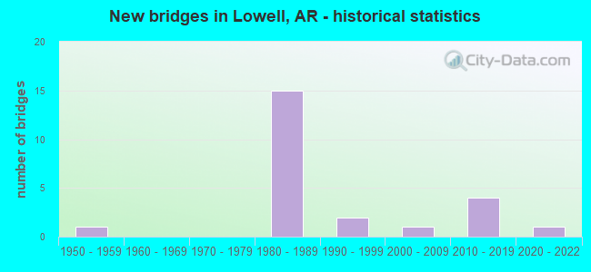
- New bridges - historical statistics
- 11950-1959
- 151980-1989
- 21990-1999
- 12000-2009
- 42010-2019
- 12020-2022
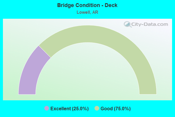
- Bridge Condition - Deck
- 25.0%Excellent
- 75.0%Good
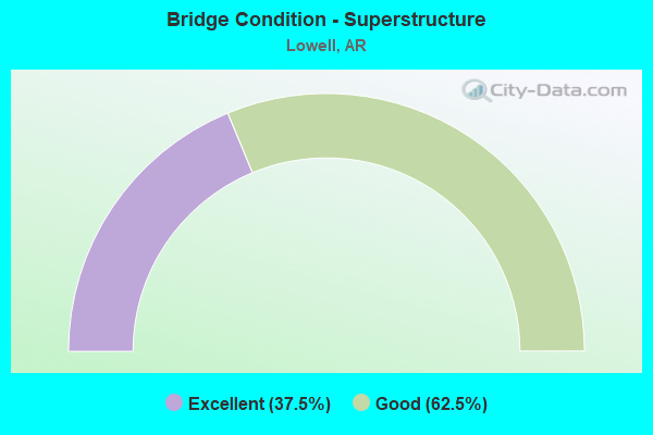
- Bridge Condition - Superstructure
- 37.5%Excellent
- 62.5%Good
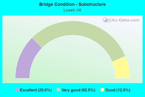
- Bridge Condition - Substructure
- 25.0%Excellent
- 62.5%Very good
- 12.5%Good
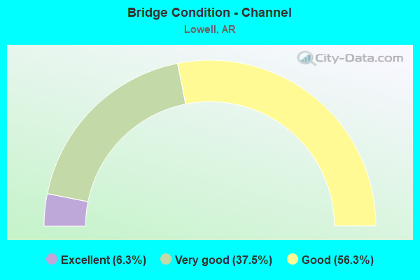
- Bridge Condition - Channel
- 6.3%Excellent
- 37.5%Very good
- 56.3%Good
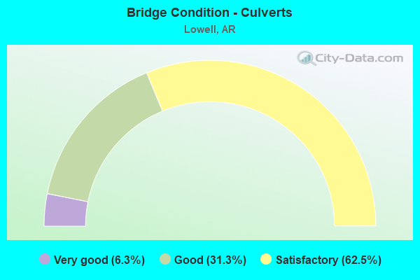
- Bridge Condition - Culverts
- 6.3%Very good
- 31.3%Good
- 62.5%Satisfactory
Find on map >> Show street view
Structure Number: 5949, Location: .72 MI W US 71B (Lat: 36.254431, Lng: -94.150881), Route carried "on" structure: State highway 264, Year Built: 1982, Status: Open, Structure Length: 8.11m (26.61ft), Average Daily Traffic: 26,000 (year 2018), Truck Traffic: 3%, Average Future Daily Traffic: 33,600 (year 2034), Design Load: HS 20, Features Intersected: I 49
Minimum Vertical Clearance: 30+ m (98+ ft), Kilometerpoint: 1.175, Lanes on structure: 3, Lanes under structure: 4, Owner: State Highway Agency, Approaching Roadway Width: 17.7m (58.1ft), Material/Design: Steel continuous, Design/Construction: Stringer/Multi-beam, Number Of Spans In Main Unit: 4, Length of Maximum Span: 26.2m (86.0ft), Curb or Sidewalk Widths: Left: 2.0m (6.6ft), Right: 2.0m (6.6ft), Curb-To-Curb Width: 17.7m (58.1ft), Out-to-Out Width: 17.7m (58.1ft)
Condition: Deck: Good, Superstructure: Good, Substructure: Good, Operating Rating: 54.4 metric tons, Method Used To Determine Operating Rating: Load Factor (LF), Inventory Rating: 32.7 metric tons, Method Used To Determine Inventory Rating: Load Factor (LF), Structural Evaluation: Better than present minimum criteria, Deck Geometry: Superior to present desirable criteria, Underclear: Somewhat better than minimum adequacy, Approach Roadway Alignment: Equal to present desirable criteria, Designated Inspection Frequency: Every 24 months, Critical Feature Inspection Frequency: Every 24 months, Inspection Date: July 2020, Deck Structure Type: Concrete Cast-file-Place, Wearing Surface/Protective System: Wearing Surface: Monolithic Concrete
Find on map >> Show street view
Structure Number: 5954, Location: .75 MI N SH 264 (Lat: 36.265411, Lng: -94.149781), Route carried "on" structure: City street 41960, Year Built: 1982, Status: Open, Structure Length: 8.11m (26.61ft), Average Daily Traffic: 141 (year 1987), Truck Traffic: 1%, Average Future Daily Traffic: 76 (year 2007), Design Load: HS 20, Features Intersected: I-49, Facility Carried by Structure: OAKWOOD Benton 1
Minimum Vertical Clearance: 30+ m (98+ ft), Kilometerpoint: 1.110, Lanes on structure: 2, Lanes under structure: 6, Owner: State Highway Agency, Approaching Roadway Width: 8.5m (27.9ft), Material/Design: Steel continuous, Design/Construction: Stringer/Multi-beam, Number Of Spans In Main Unit: 4, Length of Maximum Span: 26.2m (86.0ft), Curb-To-Curb Width: 8.5m (27.9ft), Out-to-Out Width: 9.4m (30.8ft)
Condition: Deck: Good, Superstructure: Good, Substructure: Very good, Operating Rating: 54.4 metric tons, Method Used To Determine Operating Rating: Load Factor (LF), Inventory Rating: 32.7 metric tons, Method Used To Determine Inventory Rating: Load Factor (LF), Structural Evaluation: Better than present minimum criteria, Deck Geometry: Equal to present minimum criteria, Underclear: Equal to present minimum criteria, Approach Roadway Alignment: Equal to present desirable criteria, Designated Inspection Frequency: Every 24 months, Critical Feature Inspection Frequency: Every 24 months, Inspection Date: June 2020, Deck Structure Type: Concrete Cast-file-Place, Wearing Surface/Protective System: Wearing Surface: Monolithic Concrete
Find on map >> Show street view
Structure Number: 5955, Location: 2.05 MI N SH 264 (Lat: 36.283539, Lng: -94.157181), Route carried "on" structure: City street 45800, Year Built: 1982, Status: Open, Structure Length: 9.72m (31.89ft), Average Daily Traffic: 37,748 (year 2018), Truck Traffic: 1%, Average Future Daily Traffic: 9,872 (year 2025), Design Load: HS 20, Features Intersected: I-49, Facility Carried by Structure: PG Rd. BENTON 1
Minimum Vertical Clearance: 30+ m (98+ ft), Kilometerpoint: 2.446, Lanes on structure: 6, Lanes under structure: 6, Owner: State Highway Agency, Approaching Roadway Width: 22.9m (75.1ft), Skew: 3 degrees, Material/Design: Steel continuous, Design/Construction: Stringer/Multi-beam, Number Of Spans In Main Unit: 4, Length of Maximum Span: 31.1m (102.0ft), Curb or Sidewalk Widths: Left: 2.0m (6.6ft), Right: 2.0m (6.6ft), Curb-To-Curb Width: 22.9m (75.1ft), Out-to-Out Width: 27.9m (91.5ft)
Condition: Deck: Good, Superstructure: Good, Substructure: Very good, Operating Rating: 54.4 metric tons, Method Used To Determine Operating Rating: Load Factor (LF), Inventory Rating: 32.7 metric tons, Method Used To Determine Inventory Rating: Load Factor (LF), Structural Evaluation: Better than present minimum criteria, Deck Geometry: Meets minimum limits, Underclear: Somewhat better than minimum adequacy, Approach Roadway Alignment: Equal to present desirable criteria, Designated Inspection Frequency: Every 24 months, Critical Feature Inspection Frequency: Every 24 months, Inspection Date: August 2021, Deck Structure Type: Concrete Cast-file-Place, Wearing Surface/Protective System: Wearing Surface: Monolithic Concrete
Find on map >> Show street view
Structure Number: 7313, Location: 0.04 Mi. SE of I-49 (Lat: 36.239344, Lng: -94.154744), Route carried "on" structure: Ramp US 612, Year Built: 2018, Status: Open, Structure Length: 12.65m (41.50ft), Average Daily Traffic: 10 (year 2017), Truck Traffic: 12%, Average Future Daily Traffic: 10,000 (year 2014), Design Load: HL 93, Features Intersected: Silent Grove Rd.
Minimum Vertical Clearance: 30.17m (98.98ft), Kilometerpoint: 7.854, Lanes on structure: 1, Lanes under structure: 2, Owner: State Highway Agency, Approaching Roadway Width: 8.8m (28.9ft), Skew: 4 degrees, Material/Design: Steel continuous, Design/Construction: Stringer/Multi-beam, Number Of Spans In Main Unit: 4, Length of Maximum Span: 36.9m (121.1ft), Curb-To-Curb Width: 8.8m (28.9ft), Out-to-Out Width: 9.8m (32.2ft)
Condition: Deck: Excellent, Superstructure: Excellent, Substructure: Excellent, Operating Rating: 54.4 metric tons, Method Used To Determine Operating Rating: Load and Resistance Factor (LRFR), Inventory Rating: 32.7 metric tons, Method Used To Determine Inventory Rating: Load and Resistance Factor (LRFR), Structural Evaluation: Superior to present desirable criteria, Deck Geometry: Superior to present desirable criteria, Underclear: Superior to present desirable criteria, Approach Roadway Alignment: Equal to present desirable criteria, Designated Inspection Frequency: Every 24 months, Critical Feature Inspection Frequency: Every 24 months, Inspection Date: March 2020, Deck Structure Type: Concrete Cast-file-Place, Wearing Surface/Protective System: Deck Protection: Epoxy Coated Reinforcing
Find on map >> Show street view
Structure Number: 7315, Location: 0.02 Mi. NW of I-49 (Lat: 36.240969, Lng: -94.155611), Route carried "on" structure: Ramp State highway 612, Year Built: 2018, Status: Open, Structure Length: 7.16m (23.49ft), Average Daily Traffic: 15,250 (year 2014), Truck Traffic: 12%, Average Future Daily Traffic: 37,000 (year 2034), Design Load: HL 93, Features Intersected: Goad Springs Rd.
Minimum Vertical Clearance: 30.17m (98.98ft), Kilometerpoint: 7.017, Lanes on structure: 2, Lanes under structure: 2, Owner: State Highway Agency, Approaching Roadway Width: 12.6m (41.3ft), Skew: 3 degrees, Material/Design: Steel continuous, Design/Construction: Stringer/Multi-beam, Number Of Spans In Main Unit: 3, Length of Maximum Span: 30.8m (101.0ft), Curb-To-Curb Width: 12.2m (40.0ft), Out-to-Out Width: 13.1m (43.0ft)
Condition: Deck: Excellent, Superstructure: Excellent, Substructure: Excellent, Operating Rating: 54.4 metric tons, Method Used To Determine Operating Rating: Load and Resistance Factor (LRFR), Inventory Rating: 32.7 metric tons, Method Used To Determine Inventory Rating: Load and Resistance Factor (LRFR), Structural Evaluation: Superior to present desirable criteria, Deck Geometry: Superior to present desirable criteria, Underclear: Better than present minimum criteria, Approach Roadway Alignment: Equal to present desirable criteria, Designated Inspection Frequency: Every 24 months, Critical Feature Inspection Frequency: Every 24 months, Inspection Date: March 2020, Deck Structure Type: Concrete Cast-file-Place, Wearing Surface/Protective System: Deck Protection: Epoxy Coated Reinforcing
Find on map >> Show street view
Structure Number: 7333, Location: 1.56 NE of Lowell (Lat: 36.275489, Lng: -94.119431), Route carried "on" structure: State highway 265, Year Built: 2017, Status: Not yet open, Structure Length: 20.49m (67.22ft), Average Daily Traffic: 680 (year 2018), Truck Traffic: 1%, Average Future Daily Traffic: 16,500 (year 2035), Design Load: HL 93, Features Intersected: Dogwood Dr.
Minimum Vertical Clearance: 30.17m (98.98ft), Kilometerpoint: 7.805, Lanes on structure: 3, Lanes under structure: 2, Owner: State Highway Agency, Approaching Roadway Width: 13.4m (44.0ft), Material/Design: Steel continuous, Design/Construction: Stringer/Multi-beam, Number Of Spans In Main Unit: 5, Length of Maximum Span: 45.7m (149.9ft), Curb or Sidewalk Widths: Left: 2.0m (6.6ft), Right: 1.9m (6.2ft), Curb-To-Curb Width: 14.1m (46.3ft), Out-to-Out Width: 19.0m (62.3ft)
Condition: Deck: Good, Superstructure: Excellent, Substructure: Very good, Operating Rating: 42.6 metric tons, Method Used To Determine Operating Rating: Load and Resistance Factor (LRFR), Inventory Rating: 32.7 metric tons, Method Used To Determine Inventory Rating: Load and Resistance Factor (LRFR), Structural Evaluation: Equal to present desirable criteria, Deck Geometry: Somewhat better than minimum adequacy, Underclear: Superior to present desirable criteria, Approach Roadway Alignment: Equal to present desirable criteria, Designated Inspection Frequency: Every 24 months, Critical Feature Inspection Frequency: Every 24 months, Inspection Date: October 2021, Deck Structure Type: Concrete Cast-file-Place, Wearing Surface/Protective System: Deck Protection: Epoxy Coated Reinforcing
Find on map >> Show street view
Structure Number: 20711, Location: .5 MI EAST OF US 71 (Lat: 36.248867, Lng: -94.116656), Route carried "on" structure: City street 265, Year Built: 1989, Status: Open, Structure Length: 0.73m (2.40ft), Average Daily Traffic: 9,600 (year 2015), Truck Traffic: 4%, Average Future Daily Traffic: 16,500 (year 2035), Design Load: H 20, Features Intersected: CREEK, Facility Carried by Structure: S.Old Wire Rd.
Minimum Vertical Clearance: 30+ m (98+ ft), Kilometerpoint: 2.042, Lanes on structure: 2, Owner: City or Municipal Highway Agency, Approaching Roadway Width: 6.4m (21.0ft), Skew: 3 degrees, Material/Design: Concrete, Design/Construction: Culvert, Number Of Spans In Main Unit: 2, Length of Maximum Span: 3.7m (12.1ft)
Condition: Channel: Very good, Culverts: Good, Operating Rating: 29.9 metric tons, Method Used To Determine Operating Rating: Load Factor (LF), Inventory Rating: 18.1 metric tons, Method Used To Determine Inventory Rating: Load Factor (LF), Structural Evaluation: Meets minimum limits, Waterway Adequacy: Equal to present desirable criteria, Approach Roadway Alignment: Equal to present desirable criteria, Designated Inspection Frequency: Every 48 months, Critical Feature Inspection Frequency: Every 24 months, Inspection Date: Febuary 2021
Find on map >> Show street view
Structure Number: 23104, Location: .3 MI N JCT APPLE BLOSSUM (Lat: 36.241817, Lng: -94.143242), Route carried "on" structure: City street 30965, Year Built: 1994, Status: Open, Structure Length: 1.89m (6.20ft), Average Daily Traffic: 555 (year 2018), Truck Traffic: 1%, Average Future Daily Traffic: 35 (year 2020), Features Intersected: BRANCH, Facility Carried by Structure: Lowell. KINKADE PL
Minimum Vertical Clearance: 30+ m (98+ ft), Kilometerpoint: 0.225, Lanes on structure: 2, Owner: City or Municipal Highway Agency, Approaching Roadway Width: 6.7m (22.0ft), Material/Design: Concrete, Design/Construction: Culvert, Number Of Spans In Main Unit: 6, Length of Maximum Span: 3.7m (12.1ft)
Condition: Channel: Good, Culverts: Good, Operating Rating: 49.9 metric tons, Method Used To Determine Operating Rating: Load Factor (LF), Inventory Rating: 29.9 metric tons, Method Used To Determine Inventory Rating: Load Factor (LF), Structural Evaluation: Better than present minimum criteria, Waterway Adequacy: Superior to present desirable criteria, Approach Roadway Alignment: Equal to present desirable criteria, Designated Inspection Frequency: Every 24 months, Critical Feature Inspection Frequency: Every 24 months, Inspection Date: March 2021
Find on map >> Show street view
Structure Number: 23105, Location: .3 MI. N. SH 264 (Lat: 36.256775, Lng: -94.147053), Route carried "on" structure: City street 33600, Year Built: 2006, Status: Open, Structure Length: 0.94m (3.08ft), Average Daily Traffic: 200 (year 2007), Truck Traffic: 1%, Average Future Daily Traffic: 282 (year 2027), Features Intersected: Branch, Facility Carried by Structure: Lowell. Links Dr.
Minimum Vertical Clearance: 30+ m (98+ ft), Kilometerpoint: 0.161, Lanes on structure: 2, Owner: City or Municipal Highway Agency, Approaching Roadway Width: 7.9m (25.9ft), Material/Design: Concrete, Design/Construction: Culvert, Number Of Spans In Main Unit: 4, Length of Maximum Span: 2.4m (7.9ft), Curb or Sidewalk Widths: Left: 0.0m, Right: 1.2m (3.9ft)
Condition: Channel: Very good, Culverts: Satisfactory, Operating Rating: 41.7 metric tons, Method Used To Determine Operating Rating: Load Factor (LF), Inventory Rating: 31.8 metric tons, Method Used To Determine Inventory Rating: Load Factor (LF), Structural Evaluation: Equal to present minimum criteria, Waterway Adequacy: Superior to present desirable criteria, Approach Roadway Alignment: Equal to present desirable criteria, Designated Inspection Frequency: Every 24 months, Critical Feature Inspection Frequency: Every 24 months, Inspection Date: March 2021
Find on map >> Show street view
Structure Number: 23106, Location: 0.1MI N JCT SH 264 (Lat: 36.255694, Lng: -94.145736), Route carried "on" structure: City street 16062, Year Built: 1994, Status: Open, Structure Length: 1.95m (6.40ft), Average Daily Traffic: 700 (year 2000), Truck Traffic: 1%, Average Future Daily Traffic: 987 (year 2020), Features Intersected: PUPPY CREEK, Facility Carried by Structure: LowellN DIXIELAND
Minimum Vertical Clearance: 30+ m (98+ ft), Kilometerpoint: 0.161, Lanes on structure: 4, Owner: City or Municipal Highway Agency, Approaching Roadway Width: 13.4m (44.0ft), Material/Design: Concrete, Design/Construction: Culvert, Number Of Spans In Main Unit: 6, Length of Maximum Span: 3.4m (11.2ft), Curb or Sidewalk Widths: Left: 1.5m (4.9ft), Right: 1.8m (5.9ft)
Condition: Channel: Very good, Culverts: Satisfactory, Operating Rating: 29.9 metric tons, Method Used To Determine Operating Rating: Load Factor (LF), Inventory Rating: 18.1 metric tons, Method Used To Determine Inventory Rating: Load Factor (LF), Structural Evaluation: Somewhat better than minimum adequacy, Waterway Adequacy: Superior to present desirable criteria, Approach Roadway Alignment: Equal to present desirable criteria, Designated Inspection Frequency: Every 24 months, Critical Feature Inspection Frequency: Every 24 months, Inspection Date: March 2021
Find on map >> Show street view
Structure Number: 23725, Location: 0.1M S JCT W ROBINSON AVE (Lat: 36.259850, Lng: -94.140569), Route carried "on" structure: City street 12430, Year Built: 2014, Status: Open, Structure Length: 0.73m (2.40ft), Average Daily Traffic: 1,275 (year 2018), Truck Traffic: 1%, Average Future Daily Traffic: 125 (year 2034), Features Intersected: BRANCH, Facility Carried by Structure: COLUMBIA PL Lowell
Minimum Vertical Clearance: 30+ m (98+ ft), Kilometerpoint: 0.209, Lanes on structure: 2, Owner: City or Municipal Highway Agency, Approaching Roadway Width: 7.9m (25.9ft), Skew: 3 degrees, Material/Design: Concrete, Design/Construction: Culvert, Number Of Spans In Main Unit: 2, Length of Maximum Span: 3.7m (12.1ft)
Condition: Channel: Very good, Culverts: Good, Operating Rating: 43.5 metric tons, Method Used To Determine Operating Rating: Load Factor (LF), Inventory Rating: 25.4 metric tons, Method Used To Determine Inventory Rating: Load Factor (LF), Structural Evaluation: Equal to present minimum criteria, Waterway Adequacy: Superior to present desirable criteria, Approach Roadway Alignment: Equal to present desirable criteria, Designated Inspection Frequency: Every 24 months, Critical Feature Inspection Frequency: Every 24 months, Inspection Date: November 2020
Find on map >> Show street view
Structure Number: 24171, Location: .3 MI N JCT APPLE BLOSSUM (Lat: 36.241764, Lng: -94.142408), Route carried "on" structure: City street , Year Built: 2021, Status: Open, Structure Length: 1.77m (5.81ft), Average Daily Traffic: 11,000 (year 2019), Average Future Daily Traffic: 13,200 (year 2040), Features Intersected: Branch, Facility Carried by Structure: S. Dixieland Rd.
Minimum Vertical Clearance: 30+ m (98+ ft), Kilometerpoint: 0.193, Lanes on structure: 2, Owner: City or Municipal Highway Agency, Approaching Roadway Width: 11.6m (38.1ft), Skew: 3 degrees, Material/Design: Concrete, Design/Construction: Culvert, Number Of Spans In Main Unit: 6, Length of Maximum Span: 2.4m (7.9ft), Curb or Sidewalk Widths: Left: 2.4m (7.9ft), Right: 0.0m, Curb-To-Curb Width: 11.6m (38.1ft), Out-to-Out Width: 24.7m (81.0ft)
Condition: Channel: Excellent, Culverts: Very good, Operating Rating: 46.3 metric tons, Method Used To Determine Operating Rating: Load and Resistance Factor (LRFR), Inventory Rating: 32.7 metric tons, Method Used To Determine Inventory Rating: Load and Resistance Factor (LRFR), Structural Evaluation: Equal to present desirable criteria, Deck Geometry: Somewhat better than minimum adequacy, Waterway Adequacy: Superior to present desirable criteria, Approach Roadway Alignment: Equal to present desirable criteria, Designated Inspection Frequency: Every 24 months, Critical Feature Inspection Frequency: Every 24 months, Inspection Date: March 2021
Find on map >> Show street view
Structure Number: A5948, Location: 2.74 MI N WASH CO LINE (Lat: 36.240500, Lng: -94.155211), Route carried "on" structure: Interstate 49, Year Built: 1982, Status: Open, Structure Length: 4.63m (15.19ft), Average Daily Traffic: 39,500 (year 2018), Truck Traffic: 11%, Average Future Daily Traffic: 52,000 (year 2033), Design Load: HS 20, Features Intersected: GOAD SPRINGS RD
Minimum Vertical Clearance: 30+ m (98+ ft), Kilometerpoint: 123.839, Lanes on structure: 3, Lanes under structure: 2, Base Highway Network: Yes, Owner: State Highway Agency, Approaching Roadway Width: 17.1m (56.1ft), Skew: 2 degrees, Material/Design: Steel continuous, Design/Construction: Stringer/Multi-beam, Number Of Spans In Main Unit: 3, Length of Maximum Span: 17.4m (57.1ft), Curb-To-Curb Width: 17.1m (56.1ft), Out-to-Out Width: 18.0m (59.1ft)
Condition: Deck: Good, Superstructure: Good, Substructure: Very good, Operating Rating: 54.4 metric tons, Method Used To Determine Operating Rating: Load Factor (LF), Inventory Rating: 32.7 metric tons, Method Used To Determine Inventory Rating: Load Factor (LF), Structural Evaluation: Better than present minimum criteria, Deck Geometry: Equal to present minimum criteria, Underclear: Better than present minimum criteria, Approach Roadway Alignment: Equal to present desirable criteria, Designated Inspection Frequency: Every 24 months, Critical Feature Inspection Frequency: Every 24 months, Inspection Date: June 2020, Deck Structure Type: Concrete Cast-file-Place, Wearing Surface/Protective System: Wearing Surface: Monolithic Concrete
Find on map >> Show street view
Structure Number: B5948, Location: 2.73 MI N WASH CO LINE (Lat: 36.240319, Lng: -94.155100), Route carried "on" structure: Interstate 49, Year Built: 1982, Status: Open, Structure Length: 4.54m (14.90ft), Average Daily Traffic: 39,500 (year 2018), Truck Traffic: 11%, Average Future Daily Traffic: 52,000 (year 2033), Design Load: HS 20, Features Intersected: GOAD SPRINGS RD
Minimum Vertical Clearance: 30+ m (98+ ft), Kilometerpoint: 123.807, Lanes on structure: 3, Lanes under structure: 2, Base Highway Network: Yes, Owner: State Highway Agency, Approaching Roadway Width: 17.1m (56.1ft), Skew: 2 degrees, Material/Design: Steel continuous, Design/Construction: Stringer/Multi-beam, Number Of Spans In Main Unit: 3, Length of Maximum Span: 17.4m (57.1ft), Curb-To-Curb Width: 17.1m (56.1ft), Out-to-Out Width: 18.0m (59.1ft)
Condition: Deck: Good, Superstructure: Good, Substructure: Very good, Operating Rating: 54.4 metric tons, Method Used To Determine Operating Rating: Load Factor (LF), Inventory Rating: 32.7 metric tons, Method Used To Determine Inventory Rating: Load Factor (LF), Structural Evaluation: Better than present minimum criteria, Deck Geometry: Equal to present minimum criteria, Underclear: Better than present minimum criteria, Approach Roadway Alignment: Equal to present desirable criteria, Designated Inspection Frequency: Every 24 months, Critical Feature Inspection Frequency: Every 24 months, Inspection Date: June 2020, Deck Structure Type: Concrete Cast-file-Place, Wearing Surface/Protective System: Wearing Surface: Monolithic Concrete
Find on map >> Show street view
Structure Number: X0503, Location: .72 MI S SH 264 (Lat: 36.244081, Lng: -94.151839), Route carried "on" structure: Interstate 49, Year Built: 1982, Status: Open, Structure Length: 0.79m (2.59ft), Average Daily Traffic: 79,000 (year 2018), Truck Traffic: 11%, Average Future Daily Traffic: 104,000 (year 2033), Features Intersected: CREEK
Minimum Vertical Clearance: 30+ m (98+ ft), Kilometerpoint: 124.306, Lanes on structure: 4, Base Highway Network: Yes, Owner: State Highway Agency, Approaching Roadway Width: 24.4m (80.1ft), Material/Design: Concrete, Design/Construction: Culvert, Number Of Spans In Main Unit: 3, Length of Maximum Span: 2.7m (8.9ft)
Condition: Channel: Good, Culverts: Satisfactory, Operating Rating: 32.7 metric tons, Method Used To Determine Operating Rating: Load Factor (LF), Inventory Rating: 20.0 metric tons, Method Used To Determine Inventory Rating: Load Factor (LF), Structural Evaluation: Somewhat better than minimum adequacy, Waterway Adequacy: Equal to present desirable criteria, Approach Roadway Alignment: Equal to present desirable criteria, Designated Inspection Frequency: Every 24 months, Critical Feature Inspection Frequency: Every 24 months, Inspection Date: April 2020
Find on map >> Show street view
Structure Number: X0504, Location: .26 MI SO SH 264 (Lat: 36.250669, Lng: -94.150361), Route carried "on" structure: Interstate 49, Year Built: 1982, Status: Open, Structure Length: 1.34m (4.40ft), Average Daily Traffic: 79,000 (year 2018), Truck Traffic: 11%, Average Future Daily Traffic: 104,000 (year 2033), Design Load: H 20, Features Intersected: PUPPY CREEK
Minimum Vertical Clearance: 30+ m (98+ ft), Kilometerpoint: 125.046, Lanes on structure: 8, Base Highway Network: Yes, Owner: State Highway Agency, Approaching Roadway Width: 44.8m (147.0ft), Skew: 2 degrees, Material/Design: Concrete, Design/Construction: Culvert, Number Of Spans In Main Unit: 3, Length of Maximum Span: 4.6m (15.1ft)
Condition: Channel: Good, Culverts: Satisfactory, Operating Rating: 41.7 metric tons, Method Used To Determine Operating Rating: Load Factor (LF), Inventory Rating: 25.4 metric tons, Method Used To Determine Inventory Rating: Load Factor (LF), Structural Evaluation: Equal to present minimum criteria, Waterway Adequacy: Equal to present desirable criteria, Approach Roadway Alignment: Equal to present desirable criteria, Designated Inspection Frequency: Every 24 months, Critical Feature Inspection Frequency: Every 24 months, Inspection Date: April 2020
Find on map >> Show street view
Structure Number: X0505, Location: .06 MI SO SH 264 (Lat: 36.253511, Lng: -94.147839), Route carried "on" structure: ServiceInterstate 49, Year Built: 1982, Status: Open, Structure Length: 1.16m (3.81ft), Average Daily Traffic: 53 (year 2014), Truck Traffic: 1%, Average Future Daily Traffic: 1,100 (year 2028), Design Load: H 20, Features Intersected: DITCH, Facility Carried by Structure: S 6th Plac Benton2
Minimum Vertical Clearance: 30+ m (98+ ft), Kilometerpoint: 125.448, Lanes on structure: 2, Owner: State Highway Agency, Approaching Roadway Width: 9.8m (32.2ft), Skew: 4 degrees, Material/Design: Concrete, Design/Construction: Culvert, Number Of Spans In Main Unit: 3, Length of Maximum Span: 4.0m (13.1ft)
Condition: Channel: Good, Culverts: Satisfactory, Operating Rating: 39.9 metric tons, Method Used To Determine Operating Rating: Load Factor (LF), Inventory Rating: 23.6 metric tons, Method Used To Determine Inventory Rating: Load Factor (LF), Structural Evaluation: Equal to present minimum criteria, Waterway Adequacy: Equal to present desirable criteria, Approach Roadway Alignment: Equal to present desirable criteria, Designated Inspection Frequency: Every 24 months, Critical Feature Inspection Frequency: Every 24 months, Inspection Date: April 2020
Find on map >> Show street view
Structure Number: X0506, Location: .65 MI W US 71B (Lat: 36.254419, Lng: -94.147678), Route carried "on" structure: State highway 264, Year Built: 1982, Status: Open, Structure Length: 0.79m (2.59ft), Average Daily Traffic: 26,000 (year 2018), Truck Traffic: 3%, Average Future Daily Traffic: 33,600 (year 2034), Design Load: H 20, Features Intersected: PUPPY CREEK
Minimum Vertical Clearance: 30+ m (98+ ft), Kilometerpoint: 1.046, Lanes on structure: 5, Base Highway Network: Yes, Owner: State Highway Agency, Approaching Roadway Width: 21.9m (71.9ft), Material/Design: Concrete, Design/Construction: Culvert, Number Of Spans In Main Unit: 3, Length of Maximum Span: 2.7m (8.9ft), Curb or Sidewalk Widths: Left: 0.0m, Right: 1.8m (5.9ft)
Condition: Channel: Good, Culverts: Good, Operating Rating: 50.8 metric tons, Method Used To Determine Operating Rating: Load Factor (LF), Inventory Rating: 30.8 metric tons, Method Used To Determine Inventory Rating: Load Factor (LF), Structural Evaluation: Better than present minimum criteria, Waterway Adequacy: Equal to present desirable criteria, Approach Roadway Alignment: Equal to present desirable criteria, Designated Inspection Frequency: Every 24 months, Critical Feature Inspection Frequency: Every 24 months, Inspection Date: May 2020
Find on map >> Show street view
Structure Number: X0507, Location: .01 MI N SH 264 (Lat: 36.254850, Lng: -94.147369), Route carried "on" structure: ServiceInterstate 49, Year Built: 1982, Status: Open, Structure Length: 1.65m (5.41ft), Average Daily Traffic: 53 (year 2014), Truck Traffic: 1%, Average Future Daily Traffic: 1,100 (year 2028), Design Load: H 20, Features Intersected: DITCH
Minimum Vertical Clearance: 30+ m (98+ ft), Kilometerpoint: 125.513, Lanes on structure: 2, Owner: State Highway Agency, Approaching Roadway Width: 8.5m (27.9ft), Skew: 3 degrees, Material/Design: Concrete, Design/Construction: Culvert, Number Of Spans In Main Unit: 3, Length of Maximum Span: 3.0m (9.8ft)
Condition: Channel: Good, Culverts: Good, Operating Rating: 50.8 metric tons, Method Used To Determine Operating Rating: Load Factor (LF), Inventory Rating: 30.8 metric tons, Method Used To Determine Inventory Rating: Load Factor (LF), Structural Evaluation: Better than present minimum criteria, Waterway Adequacy: Equal to present desirable criteria, Approach Roadway Alignment: Equal to present desirable criteria, Designated Inspection Frequency: Every 48 months, Critical Feature Inspection Frequency: Every 24 months, Inspection Date: March 2018
Find on map >> Show street view
Structure Number: X0508, Location: .21 MI N SH 264 (Lat: 36.256639, Lng: -94.150239), Route carried "on" structure: Interstate 49, Year Built: 1982, Status: Open, Structure Length: 0.70m (2.30ft), Average Daily Traffic: 79,000 (year 2018), Truck Traffic: 12%, Average Future Daily Traffic: 115,000 (year 2033), Design Load: H 20, Features Intersected: DITCH
Minimum Vertical Clearance: 30+ m (98+ ft), Kilometerpoint: 125.802, Lanes on structure: 8, Owner: State Highway Agency, Approaching Roadway Width: 47.9m (157.2ft), Skew: 2 degrees, Material/Design: Concrete, Design/Construction: Culvert, Number Of Spans In Main Unit: 3, Length of Maximum Span: 2.1m (6.9ft)
Condition: Channel: Very good, Culverts: Satisfactory, Operating Rating: 29.0 metric tons, Method Used To Determine Operating Rating: Load Factor (LF), Inventory Rating: 17.2 metric tons, Method Used To Determine Inventory Rating: Load Factor (LF), Structural Evaluation: Meets minimum limits, Waterway Adequacy: Equal to present desirable criteria, Approach Roadway Alignment: Equal to present desirable criteria, Designated Inspection Frequency: Every 24 months, Critical Feature Inspection Frequency: Every 24 months, Inspection Date: March 2020
Find on map >> Show street view
Structure Number: X0509, Location: 1.2 MI N SH 264 (Lat: 36.271781, Lng: -94.149969), Route carried "on" structure: Interstate 49, Year Built: 1982, Status: Open, Structure Length: 0.67m (2.20ft), Average Daily Traffic: 79,000 (year 2018), Truck Traffic: 12%, Average Future Daily Traffic: 115,000 (year 2033), Design Load: H 20, Features Intersected: DITCH
Minimum Vertical Clearance: 30+ m (98+ ft), Kilometerpoint: 127.396, Lanes on structure: 4, Base Highway Network: Yes, Owner: State Highway Agency, Approaching Roadway Width: 24.4m (80.1ft), Skew: 3 degrees, Material/Design: Concrete, Design/Construction: Culvert, Number Of Spans In Main Unit: 3, Length of Maximum Span: 2.4m (7.9ft)
Condition: Channel: Good, Culverts: Satisfactory, Operating Rating: 36.3 metric tons, Method Used To Determine Operating Rating: Load Factor (LF), Inventory Rating: 21.8 metric tons, Method Used To Determine Inventory Rating: Load Factor (LF), Structural Evaluation: Somewhat better than minimum adequacy, Waterway Adequacy: Equal to present desirable criteria, Approach Roadway Alignment: Equal to present desirable criteria, Designated Inspection Frequency: Every 24 months, Critical Feature Inspection Frequency: Every 24 months, Inspection Date: April 2020
Find on map >> Show street view
Structure Number: X0712, Location: 3.49 MI W JCT 71 & 264 (Lat: 36.259050, Lng: -94.193869), Route carried "on" structure: State highway 264, Year Built: 1952, Status: Open, Structure Length: 0.64m (2.10ft), Average Daily Traffic: 10,596 (year 2018), Truck Traffic: 1%, Average Future Daily Traffic: 7,616 (year 2028), Design Load: H 20, Features Intersected: CROSS CREEK
Minimum Vertical Clearance: 30+ m (98+ ft), Kilometerpoint: 5.472, Lanes on structure: 2, Owner: State Highway Agency, Approaching Roadway Width: 7.3m (24.0ft), Material/Design: Concrete, Design/Construction: Culvert, Number Of Spans In Main Unit: 2, Length of Maximum Span: 3.0m (9.8ft)
Condition: Channel: Very good, Culverts: Satisfactory, Operating Rating: 29.9 metric tons, Method Used To Determine Operating Rating: Load Factor (LF), Inventory Rating: 18.1 metric tons, Method Used To Determine Inventory Rating: Load Factor (LF), Structural Evaluation: Meets minimum limits, Waterway Adequacy: Equal to present desirable criteria, Approach Roadway Alignment: Equal to present desirable criteria, Designated Inspection Frequency: Every 24 months, Critical Feature Inspection Frequency: Every 24 months, Inspection Date: June 2021
Find on map >> Show street view
Structure Number: X0767, Location: .48 MI W JCT 71B&264 (Lat: 36.254361, Lng: -94.146669), Route carried "on" structure: State highway 264, Year Built: 1989, Status: Open, Structure Length: 1.62m (5.31ft), Average Daily Traffic: 25,109 (year 2018), Truck Traffic: 3%, Average Future Daily Traffic: 33,600 (year 2034), Design Load: H 20, Features Intersected: PUPPY CREEK
Minimum Vertical Clearance: 30+ m (98+ ft), Kilometerpoint: 0.885, Lanes on structure: 5, Base Highway Network: Yes, Owner: State Highway Agency, Approaching Roadway Width: 21.9m (71.9ft), Material/Design: Concrete, Design/Construction: Culvert, Number Of Spans In Main Unit: 5, Length of Maximum Span: 3.4m (11.2ft), Curb or Sidewalk Widths: Left: 1.5m (4.9ft), Right: 1.5m (4.9ft)
Condition: Channel: Good, Culverts: Satisfactory, Operating Rating: 29.9 metric tons, Method Used To Determine Operating Rating: Load Factor (LF), Inventory Rating: 18.1 metric tons, Method Used To Determine Inventory Rating: Load Factor (LF), Structural Evaluation: Meets minimum limits, Waterway Adequacy: Equal to present desirable criteria, Approach Roadway Alignment: Equal to present desirable criteria, Designated Inspection Frequency: Every 24 months, Critical Feature Inspection Frequency: Every 24 months, Inspection Date: May 2020
Find on map >> Show street view
Structure Number: X0768, Location: 0.22 MI W JCT US71B & 264 (Lat: 36.254200, Lng: -94.140900), Route carried "on" structure: State highway 264, Year Built: 1989, Status: Open, Structure Length: 1.89m (6.20ft), Average Daily Traffic: 25,109 (year 2018), Truck Traffic: 1%, Average Future Daily Traffic: 28,206 (year 2028), Design Load: H 20, Features Intersected: PUPPY CREEK
Minimum Vertical Clearance: 30+ m (98+ ft), Kilometerpoint: 0.354, Lanes on structure: 5, Base Highway Network: Yes, Owner: State Highway Agency, Approaching Roadway Width: 16.5m (54.1ft), Skew: 3 degrees, Material/Design: Concrete, Design/Construction: Culvert, Number Of Spans In Main Unit: 5, Length of Maximum Span: 3.7m (12.1ft)
Condition: Channel: Good, Culverts: Satisfactory, Operating Rating: 29.9 metric tons, Method Used To Determine Operating Rating: Load Factor (LF), Inventory Rating: 18.1 metric tons, Method Used To Determine Inventory Rating: Load Factor (LF), Structural Evaluation: Meets minimum limits, Waterway Adequacy: Equal to present desirable criteria, Approach Roadway Alignment: Equal to present desirable criteria, Designated Inspection Frequency: Every 24 months, Critical Feature Inspection Frequency: Every 24 months, Inspection Date: May 2020
Find on map >> Show street view
Structure Number: 5949, Location: .72 MI W US 71B (Lat: 36.254431, Lng: -94.150881), Route carried "under" structure: Interstate 49, Structure Length: 0. m, Average Daily Traffic: 39,000 (year 2014), Truck Traffic: 1%, Features Intersected: I 49, Facility Carried by Structure: SH 264 Benton 2
Minimum Vertical Clearance: 5.39m (17.68ft), Kilometerpoint: 125.464, Length of Maximum Span: 0.0m
Find on map >> Show street view
Structure Number: 5949, Location: .72 MI W US 71B (Lat: 36.254431, Lng: -94.150881), Route carried "under" structure: Interstate 49, Structure Length: 0. m, Average Daily Traffic: 39,000 (year 2014), Truck Traffic: 1%, Features Intersected: I 49, Facility Carried by Structure: SH 264 Benton 2
Minimum Vertical Clearance: 4.96m (16.27ft), Kilometerpoint: 125.464, Length of Maximum Span: 0.0m
Find on map >> Show street view
Structure Number: 5954, Location: .75 MI N SH 264 (Lat: 36.265411, Lng: -94.149781), Route carried "under" structure: Interstate 49, Structure Length: 0. m, Average Daily Traffic: 39,000 (year 2014), Truck Traffic: 12%, Features Intersected: I-49, Facility Carried by Structure: OAKWOOD Benton 1
Minimum Vertical Clearance: 5.12m (16.80ft), Kilometerpoint: 125.835, Length of Maximum Span: 0.0m
Find on map >> Show street view
Structure Number: 5955, Location: 2.05 MI N SH 264 (Lat: 36.283539, Lng: -94.157181), Route carried "under" structure: Interstate 49, Structure Length: 0. m, Average Daily Traffic: 39,500 (year 2014), Truck Traffic: 12%, Features Intersected: I-49 NB Lanes, Facility Carried by Structure: PG Rd. BENTON 1
Minimum Vertical Clearance: 5.05m (16.57ft), Kilometerpoint: 128.828, Length of Maximum Span: 0.0m
Find on map >> Show street view
Structure Number: 5955, Location: 2.05 MI N SH 264 (Lat: 36.283539, Lng: -94.157181), Route carried "under" structure: Interstate 49, Structure Length: 0. m, Average Daily Traffic: 39,500 (year 2014), Truck Traffic: 12%, Features Intersected: I-49 SB Lanes, Facility Carried by Structure: PG Rd. BENTON 1
Minimum Vertical Clearance: 4.96m (16.27ft), Kilometerpoint: 128.828, Length of Maximum Span: 0.0m
Find on map >> Show street view
Structure Number: 7315, Location: 0.02 Mi. NW of I-49 (Lat: 36.240969, Lng: -94.155611), Route carried "under" structure: Ramp City street , Structure Length: 0. m, Features Intersected: S. Goad Springs St., Facility Carried by Structure: SH 612 NW ramp
Minimum Vertical Clearance: 30.17m (98.98ft), Kilometerpoint: 7.017, Length of Maximum Span: 0.0m
Find on map >> Show street view
Structure Number: 7333, Location: 1.56 NE of Lowell (Lat: 36.275489, Lng: -94.119431), Route carried "under" structure: County highway 622, Structure Length: 0. m, Features Intersected: CR 622 / Dogwood Drive, Facility Carried by Structure: SH 265
Minimum Vertical Clearance: 21.42m (70.28ft), Kilometerpoint: 0.000, Length of Maximum Span: 0.0m
Find on map >> Show street view
Structure Number: A5948, Location: 2.74 MI N WASH CO LINE (Lat: 36.240500, Lng: -94.155211), Route carried "under" structure: County highway 240, Structure Length: 0. m, Average Daily Traffic: 500 (year 1986), Truck Traffic: 1%, Features Intersected: GOAD SPRING RD, Facility Carried by Structure: I-49, SB Benton 1
Minimum Vertical Clearance: 7.01m (23.00ft), Kilometerpoint: 4.394, Length of Maximum Span: 0.0m
Find on map >> Show street view
Structure Number: B5948, Location: 2.73 MI N WASH CO LINE (Lat: 36.240319, Lng: -94.155100), Route carried "under" structure: County highway 240, Structure Length: 0. m, Average Daily Traffic: 500 (year 1986), Truck Traffic: 1%, Features Intersected: GOAD SPRING RD, Facility Carried by Structure: I-49 NB Benton 1
Minimum Vertical Clearance: 5.45m (17.88ft), Kilometerpoint: 4.394, Length of Maximum Span: 0.0m