Bridge Statistics for Lowville, New York (NY)
Condition, Traffic, Stress, Structural Evaluation, Project Costs
- National Bridge Inventory (NBI) Statistics
- 17Number of bridges
- 154ft / 47.5mTotal length
- $18,399,000Total costs
- 36,408Total average daily traffic
- 3,255Total average daily truck traffic
- National Bridge Inventory (NBI) Registered Bridges for Lowville
- No street view available for this location
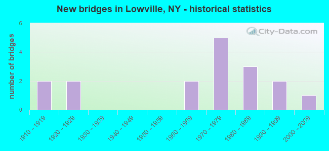
- New bridges - historical statistics
- 21910-1919
- 21920-1929
- 21960-1969
- 51970-1979
- 31980-1989
- 21990-1999
- 12000-2009

- Reconstructed bridges - Historical Statistics
- 31990-1999
- 02000-2009
- 12010-2019
- 12020-2022


- Bridge Condition - Deck
- 21.4%Excellent
- 7.1%Very good
- 21.4%Good
- 28.6%Satisfactory
- 7.1%Fair
- 14.3%Poor

- Bridge Condition - Superstructure
- 20.0%Excellent
- 6.7%Very good
- 13.3%Good
- 20.0%Satisfactory
- 33.3%Fair
- 6.7%Poor

- Bridge Condition - Substructure
- 13.3%Very good
- 20.0%Good
- 33.3%Satisfactory
- 26.7%Fair
- 6.7%Poor

- Bridge Condition - Channel
- 6.3%Very good
- 43.8%Good
- 43.8%Satisfactory
- 6.3%Fair
Find on map >> Show street view
Structure Number: 10096, Location: IN LOWVILLE (Lat: 43.784028, Lng: -75.490289), Route carried "on" structure: State highway 12, Year Built: 1913, Status: Open, Structure Length: 1.68m (5.51ft), Average Daily Traffic: 10,118 (year 2016), Truck Traffic: 8%, Average Future Daily Traffic: 10,214 (year 2040), Design Load: H 20, Features Intersected: MILL CREEK
Minimum Vertical Clearance: 30+ m (98+ ft), Kilometerpoint: 34.449, Lanes on structure: 2, Base Highway Network: Yes, Owner: State Highway Agency, Approaching Roadway Width: 13.4m (44.0ft), Skew: 1 degrees, Material/Design: Concrete, Design/Construction: Arch - Deck, Number Of Spans In Main Unit: 1, Length of Maximum Span: 16.1m (52.8ft), Curb or Sidewalk Widths: Left: 2.2m (7.2ft), Right: 2.2m (7.2ft), Curb-To-Curb Width: 12.7m (41.7ft), Out-to-Out Width: 18.4m (60.4ft)
Condition: Superstructure: Satisfactory, Substructure: Good, Channel: Good, Operating Rating: 56.2 metric tons, Method Used To Determine Operating Rating: Field evaluation and documented engineering judgment, Inventory Rating: 22.8 metric tons, Method Used To Determine Inventory Rating: Field evaluation and documented engineering judgment, Structural Evaluation: Somewhat better than minimum adequacy, Deck Geometry: Somewhat better than minimum adequacy, Waterway Adequacy: Equal to present desirable criteria, Approach Roadway Alignment: Equal to present desirable criteria, Length Of Structure Improvement: 1.67m (5.48ft), Designated Inspection Frequency: Every 24 months, Inspection Date: October 2020, Bridge Improvement Cost: $619,000, Roadway Improvement Cost: $363,000, Total Project Cost: $982,000 ( Estimate for 2021), Deck Structure Type: Concrete Cast-file-Place, Wearing Surface/Protective System: Wearing Surface: Bituminous
Find on map >> Show street view
Structure Number: 100961, Location: .5 MI W OF LOWVILLE (Lat: 43.787375, Lng: -75.506508), Route carried "on" structure: State highway 12, Year Built: 1975, Status: Open, Structure Length: 6.86m (22.51ft), Average Daily Traffic: 3,460 (year 2016), Truck Traffic: 15%, Average Future Daily Traffic: 3,492 (year 2040), Design Load: HS 20, Features Intersected: MILL CREEK
Minimum Vertical Clearance: 30+ m (98+ ft), Kilometerpoint: 35.929, Lanes on structure: 2, Base Highway Network: Yes, Owner: State Highway Agency, Approaching Roadway Width: 12.2m (40.0ft), Material/Design: Steel, Design/Construction: Stringer/Multi-beam, Number Of Spans In Main Unit: 1, Length of Maximum Span: 67.1m (220.1ft), Curb-To-Curb Width: 12.2m (40.0ft), Out-to-Out Width: 12.8m (42.0ft)
Condition: Deck: Satisfactory, Superstructure: Fair, Substructure: Satisfactory, Channel: Good, Operating Rating: 76.2 metric tons, Method Used To Determine Operating Rating: Load Factor (LF), Inventory Rating: 29.0 metric tons, Method Used To Determine Inventory Rating: Load Factor (LF), Structural Evaluation: Somewhat better than minimum adequacy, Deck Geometry: Equal to present minimum criteria, Waterway Adequacy: Equal to present minimum criteria, Approach Roadway Alignment: Equal to present desirable criteria, Length Of Structure Improvement: 6.85m (22.47ft), Designated Inspection Frequency: Every 24 months, Inspection Date: August 2021, Bridge Improvement Cost: $2,028,000, Roadway Improvement Cost: $1,187,000, Total Project Cost: $3,215,000 ( Estimate for 2021), Deck Structure Type: Concrete Cast-file-Place, Wearing Surface/Protective System: Wearing Surface: Monolithic Concrete
Find on map >> Show street view
Structure Number: 100962, Location: 0.5 MI N JCT 12 + 177 (Lat: 43.796994, Lng: -75.552764), Route carried "on" structure: State highway 12, Year Built: 1928, Status: Open, Structure Length: 1.07m (3.51ft), Average Daily Traffic: 1,933 (year 2018), Truck Traffic: 13%, Average Future Daily Traffic: 1,951 (year 2040), Design Load: H 20, Features Intersected: MILL CREEK
Minimum Vertical Clearance: 30+ m (98+ ft), Kilometerpoint: 39.935, Lanes on structure: 2, Base Highway Network: Yes, Owner: State Highway Agency, Approaching Roadway Width: 9.1m (29.9ft), Material/Design: Steel, Design/Construction: Stringer/Multi-beam, Number Of Spans In Main Unit: 1, Length of Maximum Span: 9.7m (31.8ft), Curb-To-Curb Width: 9.1m (29.9ft), Out-to-Out Width: 10.0m (32.8ft)
Condition: Deck: Poor, Superstructure: Poor, Substructure: Fair, Channel: Satisfactory, Operating Rating: 48.1 metric tons, Method Used To Determine Operating Rating: Load Factor (LF), Inventory Rating: 28.1 metric tons, Method Used To Determine Inventory Rating: Load Factor (LF), Structural Evaluation: Meets minimum limits, Deck Geometry: Somewhat better than minimum adequacy, Waterway Adequacy: Equal to present minimum criteria, Approach Roadway Alignment: Equal to present desirable criteria, Length Of Structure Improvement: 1.06m (3.48ft), Designated Inspection Frequency: Every 24 months, Inspection Date: November 2020, Bridge Improvement Cost: $405,000, Roadway Improvement Cost: $237,000, Total Project Cost: $642,000 ( Estimate for 2021), Deck Structure Type: Concrete Cast-file-Place, Wearing Surface/Protective System: Wearing Surface: Bituminous
Find on map >> Show street view
Structure Number: 106959, Location: 2.5 MI W JCT RTE 12+26 (Lat: 43.792608, Lng: -75.539803), Route carried "on" structure: State highway 12, Year Built: 1985, Status: Open, Structure Length: 0.70m (2.30ft), Average Daily Traffic: 3,460 (year 2016), Truck Traffic: 15%, Average Future Daily Traffic: 3,492 (year 2040), Design Load: HS 20, Features Intersected: MILL CREEK TRIBUTARY
Minimum Vertical Clearance: 30+ m (98+ ft), Kilometerpoint: 38.729, Lanes on structure: 2, Base Highway Network: Yes, Owner: State Highway Agency, Approaching Roadway Width: 12.5m (41.0ft), Material/Design: Aluminum, Iron, Design/Construction: Culvert, Number Of Spans In Main Unit: 1, Length of Maximum Span: 6.7m (22.0ft), Curb-To-Curb Width: 12.2m (40.0ft), Out-to-Out Width: 12.8m (42.0ft)
Condition: Channel: Satisfactory, Culverts: Good, Operating Rating: 77.3 metric tons, Method Used To Determine Operating Rating: Field evaluation and documented engineering judgment, Inventory Rating: 32.7 metric tons, Method Used To Determine Inventory Rating: Field evaluation and documented engineering judgment, Structural Evaluation: Better than present minimum criteria, Deck Geometry: Equal to present minimum criteria, Waterway Adequacy: Somewhat better than minimum adequacy, Approach Roadway Alignment: Equal to present desirable criteria, Length Of Structure Improvement: 0.70m (2.30ft), Designated Inspection Frequency: Every 24 months, Inspection Date: June 2020, Bridge Improvement Cost: $180,000, Roadway Improvement Cost: $105,000, Total Project Cost: $286,000 ( Estimate for 2021), Wearing Surface/Protective System: Wearing Surface: Bituminous
Find on map >> Show street view
Structure Number: 107478, Location: 3.5MI N JCT RTS 12 & 812 (Lat: 43.822456, Lng: -75.463650), Route carried "on" structure: State highway 812, Year Built: 1992, Status: Open, Structure Length: 10.67m (35.01ft), Average Daily Traffic: 3,902 (year 2016), Truck Traffic: 8%, Average Future Daily Traffic: 3,939 (year 2040), Design Load: HS 20, Features Intersected: BLACK RV OVERFLOW
Minimum Vertical Clearance: 30+ m (98+ ft), Kilometerpoint: 5.326, Lanes on structure: 2, Base Highway Network: Yes, Owner: State Highway Agency, Approaching Roadway Width: 13.4m (44.0ft), Skew: 3 degrees, Material/Design: Steel continuous, Design/Construction: Stringer/Multi-beam, Number Of Spans In Main Unit: 3, Length of Maximum Span: 42.0m (137.8ft), Curb-To-Curb Width: 13.4m (44.0ft), Out-to-Out Width: 14.0m (45.9ft)
Condition: Deck: Satisfactory, Superstructure: Good, Substructure: Very good, Channel: Very good, Operating Rating: 76.2 metric tons, Method Used To Determine Operating Rating: Load Factor (LF), Inventory Rating: 39.0 metric tons, Method Used To Determine Inventory Rating: Load Factor (LF), Structural Evaluation: Better than present minimum criteria, Deck Geometry: Better than present minimum criteria, Waterway Adequacy: Equal to present desirable criteria, Approach Roadway Alignment: Equal to present desirable criteria, Length Of Structure Improvement: 10.66m (34.97ft), Designated Inspection Frequency: Every 24 months, Inspection Date: August 2020, Bridge Improvement Cost: $2,775,000, Roadway Improvement Cost: $1,625,000, Total Project Cost: $4,399,000 ( Estimate for 2021), Deck Structure Type: Concrete Cast-file-Place, Wearing Surface/Protective System: Wearing Surface: Integral Concrete, Deck Protection: Epoxy Coated Reinforcing
Find on map >> Show street view
Structure Number: 222056, Location: 4 MI NW OF LOWVILLE (Lat: 43.808197, Lng: -75.547267), Route carried "on" structure: ServiceOther road , Year Built: 1990, Status: Open, Structure Length: 1.22m (4.00ft), Average Daily Traffic: 156 (year 2020), Truck Traffic: 7%, Average Future Daily Traffic: 218 (year 2040), Features Intersected: MILL CREEK, Facility Carried by Structure: BICKFORD ROAD
Minimum Vertical Clearance: 30+ m (98+ ft), Kilometerpoint: 0.998, Lanes on structure: 2, Owner: Town or Township Highway Agency, Approaching Roadway Width: 6.4m (21.0ft), Material/Design: Steel, Design/Construction: Stringer/Multi-beam, Number Of Spans In Main Unit: 1, Length of Maximum Span: 11.2m (36.7ft), Curb-To-Curb Width: 7.2m (23.6ft), Out-to-Out Width: 7.4m (24.3ft)
Condition: Deck: Satisfactory, Superstructure: Fair, Substructure: Satisfactory, Channel: Fair, Operating Rating: 54.4 metric tons, Method Used To Determine Operating Rating: Load Factor (LF), Inventory Rating: 32.7 metric tons, Method Used To Determine Inventory Rating: Load Factor (LF), Structural Evaluation: Somewhat better than minimum adequacy, Deck Geometry: Meets minimum limits, Waterway Adequacy: Meets minimum limits, Approach Roadway Alignment: Meets minimum limits, Length Of Structure Improvement: 1.21m (3.97ft), Designated Inspection Frequency: Every 24 months, Inspection Date: August 2020, Bridge Improvement Cost: $241,000, Roadway Improvement Cost: $141,000, Total Project Cost: $383,000 ( Estimate for 2021), Deck Structure Type: Concrete Cast-file-Place, Wearing Surface/Protective System: Wearing Surface: Bituminous
Find on map >> Show street view
Structure Number: 222058, Location: 0.7 MI SW OF LOWVILLE (Lat: 43.780536, Lng: -75.506564), Route carried "on" structure: Other road , Year Built: 1975, Year Reconstructed: 1999, Status: Open, Structure Length: 1.19m (3.90ft), Average Daily Traffic: 389 (year 2018), Truck Traffic: 10%, Average Future Daily Traffic: 545 (year 2038), Design Load: HS 25 or greater, Features Intersected: MILL CREEK, Facility Carried by Structure: BARDO ROAD
Minimum Vertical Clearance: 30+ m (98+ ft), Kilometerpoint: 0.467, Lanes on structure: 2, Owner: Town or Township Highway Agency, Approaching Roadway Width: 7.6m (24.9ft), Material/Design: Prestressed concrete, Design/Construction: Box Beam or Girders - Multiple, Number Of Spans In Main Unit: 1, Length of Maximum Span: 11.2m (36.7ft), Curb-To-Curb Width: 7.1m (23.3ft), Out-to-Out Width: 7.8m (25.6ft)
Condition: Deck: Excellent, Superstructure: Excellent, Substructure: Satisfactory, Channel: Good, Operating Rating: 72.6 metric tons, Method Used To Determine Operating Rating: Load Factor (LF), Inventory Rating: 43.5 metric tons, Method Used To Determine Inventory Rating: Load Factor (LF), Structural Evaluation: Equal to present minimum criteria, Deck Geometry: Meets minimum limits, Waterway Adequacy: Somewhat better than minimum adequacy, Approach Roadway Alignment: Better than present minimum criteria, Length Of Structure Improvement: 1.18m (3.87ft), Designated Inspection Frequency: Every 24 months, Inspection Date: October 2021, Bridge Improvement Cost: $215,000, Roadway Improvement Cost: $126,000, Total Project Cost: $341,000 ( Estimate for 2021), Wearing Surface/Protective System: Wearing Surface: Bituminous, Membrane: Other
Find on map >> Show street view
Structure Number: 22671, Location: 1.0SW LOWVIL-MARTNSBRG RD (Lat: 43.773344, Lng: -75.503092), Route carried "on" structure: Other road , Year Built: 1979, Status: Posted for load, Structure Length: 0.91m (2.99ft), Average Daily Traffic: 101 (year 2020), Truck Traffic: 7%, Average Future Daily Traffic: 141 (year 2040), Features Intersected: MILL CREEK, Facility Carried by Structure: MC CUE ROAD
Minimum Vertical Clearance: 30+ m (98+ ft), Kilometerpoint: 0.032, Lanes on structure: 2, Owner: Town or Township Highway Agency, Approaching Roadway Width: 6.1m (20.0ft), Skew: 3 degrees, Material/Design: Steel, Design/Construction: Stringer/Multi-beam, Number Of Spans In Main Unit: 1, Length of Maximum Span: 8.5m (27.9ft), Curb-To-Curb Width: 7.5m (24.6ft), Out-to-Out Width: 8.0m (26.2ft)
Condition: Deck: Good, Superstructure: Satisfactory, Substructure: Good, Channel: Good, Operating Rating: 25.3 metric tons, Method Used To Determine Operating Rating: Load and Resistance Factor Rating (LRFR) rating reported by rating factor(RF) method using HL-93 loadings, Inventory Rating: 19.4 metric tons, Method Used To Determine Inventory Rating: Load and Resistance Factor Rating (LRFR) rating reported by rating factor(RF) method using HL-93 loadings, Structural Evaluation: Somewhat better than minimum adequacy, Deck Geometry: Somewhat better than minimum adequacy, Waterway Adequacy: Somewhat better than minimum adequacy, Approach Roadway Alignment: Equal to present desirable criteria, Bridge Posting: Required (Relationship of Operating Rating to Maximum Legal Load: 30.0 - 39.9% below), Length Of Structure Improvement: 0.91m (2.99ft), Designated Inspection Frequency: Every 12 months, Inspection Date: September 2021, Bridge Improvement Cost: $291,000, Roadway Improvement Cost: $171,000, Total Project Cost: $462,000 ( Estimate for 2021), Deck Structure Type: Concrete Cast-file-Place, Wearing Surface/Protective System: Wearing Surface: Bituminous
Find on map >> Show street view
Structure Number: 322057, Location: 0.8 MI NE OF W LOWVILLE (Lat: 43.797639, Lng: -75.538347), Route carried "on" structure: Other road , Year Built: 1972, Year Reconstructed: 2020, Status: Open, Structure Length: 1.13m (3.71ft), Average Daily Traffic: 93 (year 2014), Truck Traffic: 7%, Average Future Daily Traffic: 130 (year 2034), Design Load: HL 93, Features Intersected: MILL CREEK, Facility Carried by Structure: GORDON ROAD
Minimum Vertical Clearance: 30+ m (98+ ft), Kilometerpoint: 0.579, Lanes on structure: 2, Owner: Town or Township Highway Agency, Approaching Roadway Width: 6.1m (20.0ft), Material/Design: Prestressed concrete, Design/Construction: Box Beam or Girders - Multiple, Number Of Spans In Main Unit: 1, Length of Maximum Span: 11.3m (37.1ft), Curb-To-Curb Width: 7.0m (23.0ft), Out-to-Out Width: 8.0m (26.2ft)
Condition: Deck: Excellent, Superstructure: Excellent, Substructure: Satisfactory, Channel: Good, Inventory Rating: 62.6 metric tons, Method Used To Determine Inventory Rating: Load Factor (LF), Structural Evaluation: Equal to present minimum criteria, Deck Geometry: Somewhat better than minimum adequacy, Waterway Adequacy: Somewhat better than minimum adequacy, Approach Roadway Alignment: Better than present minimum criteria, Length Of Structure Improvement: 1.12m (3.67ft), Designated Inspection Frequency: Every 24 months, Inspection Date: September 2020, Bridge Improvement Cost: $262,000, Roadway Improvement Cost: $154,000, Total Project Cost: $416,000 ( Estimate for 2021), Wearing Surface/Protective System: Wearing Surface: Bituminous, Membrane: Other
Find on map >> Show street view
Structure Number: 333978, Location: 0.5 MI E OF LOWVILLE (Lat: 43.783206, Lng: -75.478189), Route carried "on" structure: County highway , Year Built: 1963, Year Reconstructed: 1996, Status: Open, Structure Length: 3.23m (10.60ft), Average Daily Traffic: 5,554 (year 2016), Truck Traffic: 6%, Average Future Daily Traffic: 7,776 (year 2036), Features Intersected: MILL CREEK, Facility Carried by Structure: EAST STATE STREET
Minimum Vertical Clearance: 30+ m (98+ ft), Kilometerpoint: 0.981, Lanes on structure: 2, Owner: County Highway Agency, Approaching Roadway Width: 6.7m (22.0ft), Material/Design: Steel, Design/Construction: Stringer/Multi-beam, Number Of Spans In Main Unit: 2, Length of Maximum Span: 15.5m (50.9ft), Curb or Sidewalk Widths: Left: 0.0m, Right: 1.5m (4.9ft), Curb-To-Curb Width: 7.3m (24.0ft), Out-to-Out Width: 9.4m (30.8ft)
Condition: Deck: Satisfactory, Superstructure: Good, Substructure: Fair, Channel: Satisfactory, Operating Rating: 53.5 metric tons, Method Used To Determine Operating Rating: Load Factor (LF), Inventory Rating: 30.8 metric tons, Method Used To Determine Inventory Rating: Load Factor (LF), Structural Evaluation: Somewhat better than minimum adequacy, Deck Geometry: High priority of replacement, Waterway Adequacy: Meets minimum limits, Approach Roadway Alignment: Equal to present desirable criteria, Length Of Structure Improvement: 3.23m (10.60ft), Designated Inspection Frequency: Every 24 months, Inspection Date: July 2020, Bridge Improvement Cost: $705,000, Roadway Improvement Cost: $413,000, Total Project Cost: $1,118,000 ( Estimate for 2021), Deck Structure Type: Concrete Cast-file-Place, Wearing Surface/Protective System: Wearing Surface: Integral Concrete
Find on map >> Show street view
Structure Number: 333979, Location: 0.2 MI W OF WATSON (Lat: 43.775264, Lng: -75.440944), Route carried "on" structure: County highway , Year Built: 1963, Year Reconstructed: 2004, Status: Open, Structure Length: 11.43m (37.50ft), Average Daily Traffic: 3,991 (year 2016), Truck Traffic: 6%, Average Future Daily Traffic: 5,587 (year 2036), Design Load: HS 25 or greater, Features Intersected: BLACK RIVER, Facility Carried by Structure: NUMBER FOUR ROAD
Minimum Vertical Clearance: 30+ m (98+ ft), Kilometerpoint: 2.944, Lanes on structure: 2, Owner: County Highway Agency, Approaching Roadway Width: 8.5m (27.9ft), Skew: 4 degrees, Material/Design: Steel continuous, Design/Construction: Stringer/Multi-beam, Number Of Spans In Main Unit: 4, Length of Maximum Span: 28.0m (91.9ft), Curb or Sidewalk Widths: Left: 1.7m (5.6ft), Right: 0.0m, Curb-To-Curb Width: 8.4m (27.6ft), Out-to-Out Width: 10.2m (33.5ft)
Condition: Deck: Very good, Superstructure: Very good, Substructure: Very good, Channel: Good, Operating Rating: 74.4 metric tons, Method Used To Determine Operating Rating: Load Factor (LF), Inventory Rating: 44.5 metric tons, Method Used To Determine Inventory Rating: Load Factor (LF), Structural Evaluation: Equal to present desirable criteria, Deck Geometry: High priority of corrective action, Waterway Adequacy: Somewhat better than minimum adequacy, Approach Roadway Alignment: Better than present minimum criteria, Length Of Structure Improvement: 11.43m (37.50ft), Designated Inspection Frequency: Every 24 months, Underwater Inspection Frequency: Every 60 months, Inspection Date: July 2020, Underwater Inspection Date: October 2018, Bridge Improvement Cost: $2,135,000, Roadway Improvement Cost: $1,250,000, Total Project Cost: $3,386,000 ( Estimate for 2021), Deck Structure Type: Concrete Cast-file-Place, Wearing Surface/Protective System: Wearing Surface: Integral Concrete, Deck Protection: Epoxy Coated Reinforcing
Find on map >> Show street view
Structure Number: 334018, Location: AT LOWVILLE (Lat: 43.784339, Lng: -75.498672), Route carried "on" structure: Other road , Year Built: 1972, Year Reconstructed: 2016, Status: Open, Structure Length: 1.83m (6.00ft), Average Daily Traffic: 129 (year 2020), Truck Traffic: 4%, Average Future Daily Traffic: 181 (year 2040), Features Intersected: MILL CREEK, Facility Carried by Structure: CEMETERY ROAD
Minimum Vertical Clearance: 30+ m (98+ ft), Kilometerpoint: 0.451, Lanes on structure: 2, Owner: County Highway Agency, Approaching Roadway Width: 6.7m (22.0ft), Material/Design: Steel, Design/Construction: Stringer/Multi-beam, Number Of Spans In Main Unit: 1, Length of Maximum Span: 17.6m (57.7ft), Curb-To-Curb Width: 7.5m (24.6ft), Out-to-Out Width: 7.6m (24.9ft)
Condition: Deck: Excellent, Superstructure: Fair, Substructure: Fair, Channel: Satisfactory, Operating Rating: 36.3 metric tons, Method Used To Determine Operating Rating: Load Factor (LF), Inventory Rating: 20.9 metric tons, Method Used To Determine Inventory Rating: Load Factor (LF), Structural Evaluation: Somewhat better than minimum adequacy, Deck Geometry: Somewhat better than minimum adequacy, Waterway Adequacy: Somewhat better than minimum adequacy, Approach Roadway Alignment: Equal to present minimum criteria, Length Of Structure Improvement: 1.82m (5.97ft), Designated Inspection Frequency: Every 24 months, Inspection Date: July 2020, Bridge Improvement Cost: $452,000, Roadway Improvement Cost: $265,000, Total Project Cost: $717,000 ( Estimate for 2021), Deck Structure Type: Corrugated Steel, Wearing Surface/Protective System: Wearing Surface: Bituminous
Find on map >> Show street view
Structure Number: 334019, Location: 0.4 MI SW OF LOWVILLE (Lat: 43.780622, Lng: -75.501497), Route carried "on" structure: Other road , Year Built: 1987, Status: Posted for load, Structure Length: 1.34m (4.40ft), Average Daily Traffic: 107 (year 2020), Truck Traffic: 7%, Average Future Daily Traffic: 150 (year 2040), Features Intersected: MILL CREEK TRIBUTARY, Facility Carried by Structure: CEMETERY ROAD
Minimum Vertical Clearance: 30+ m (98+ ft), Kilometerpoint: 0.161, Lanes on structure: 1, Owner: County Highway Agency, Approaching Roadway Width: 4.0m (13.1ft), Material/Design: Steel, Design/Construction: Stringer/Multi-beam, Number Of Spans In Main Unit: 1, Length of Maximum Span: 12.1m (39.7ft), Curb-To-Curb Width: 5.0m (16.4ft), Out-to-Out Width: 5.1m (16.7ft)
Condition: Deck: Good, Superstructure: Fair, Substructure: Fair, Channel: Good, Operating Rating: 22.7 metric tons, Method Used To Determine Operating Rating: Load and Resistance Factor Rating (LRFR) rating reported by rating factor(RF) method using HL-93 loadings, Inventory Rating: 17.5 metric tons, Method Used To Determine Inventory Rating: Load and Resistance Factor Rating (LRFR) rating reported by rating factor(RF) method using HL-93 loadings, Structural Evaluation: Somewhat better than minimum adequacy, Deck Geometry: High priority of replacement, Waterway Adequacy: Superior to present desirable criteria, Approach Roadway Alignment: Meets minimum limits, Bridge Posting: Required (Relationship of Operating Rating to Maximum Legal Load: > 39.9% below), Length Of Structure Improvement: 1.34m (4.40ft), Designated Inspection Frequency: Every 12 months, Inspection Date: May 2021, Bridge Improvement Cost: $220,000, Roadway Improvement Cost: $129,000, Total Project Cost: $349,000 ( Estimate for 2021), Deck Structure Type: Concrete Cast-file-Place, Wearing Surface/Protective System: Wearing Surface: Integral Concrete
Find on map >> Show street view
Structure Number: 33402, Location: VILLAGE OF LOWVILLE (Lat: 43.784483, Lng: -75.493594), Route carried "on" structure: Other road , Year Built: 2001, Status: Open, Structure Length: 2.32m (7.61ft), Average Daily Traffic: 766 (year 2018), Truck Traffic: 4%, Average Future Daily Traffic: 1,072 (year 2038), Design Load: HS 25 or greater, Features Intersected: MILL CREEK, Facility Carried by Structure: CASCADE AVENUE
Minimum Vertical Clearance: 30+ m (98+ ft), Kilometerpoint: 0.209, Lanes on structure: 2, Owner: County Highway Agency, Approaching Roadway Width: 7.3m (24.0ft), Skew: 2 degrees, Material/Design: Prestressed concrete, Design/Construction: Box Beam or Girders - Multiple, Number Of Spans In Main Unit: 1, Length of Maximum Span: 22.1m (72.5ft), Curb or Sidewalk Widths: Left: 2.4m (7.9ft), Right: 2.4m (7.9ft), Curb-To-Curb Width: 7.8m (25.6ft), Out-to-Out Width: 13.1m (43.0ft)
Condition: Deck: Fair, Superstructure: Excellent, Substructure: Satisfactory, Channel: Satisfactory, Operating Rating: 69.9 metric tons, Method Used To Determine Operating Rating: Load Factor (LF), Inventory Rating: 40.8 metric tons, Method Used To Determine Inventory Rating: Load Factor (LF), Structural Evaluation: Equal to present minimum criteria, Deck Geometry: Meets minimum limits, Waterway Adequacy: Somewhat better than minimum adequacy, Approach Roadway Alignment: Equal to present desirable criteria, Length Of Structure Improvement: 2.31m (7.58ft), Designated Inspection Frequency: Every 24 months, Inspection Date: October 2021, Bridge Improvement Cost: $620,000, Roadway Improvement Cost: $363,000, Total Project Cost: $983,000 ( Estimate for 2021), Wearing Surface/Protective System: Wearing Surface: Monolithic Concrete
Find on map >> Show street view
Structure Number: 335834, Location: 0.6 MI E OF W. LOWVILLE (Lat: 43.794092, Lng: -75.538250), Route carried "on" structure: Other road , Year Built: 1925, Status: Posted for load, Structure Length: 1.13m (3.71ft), Average Daily Traffic: 93 (year 2014), Truck Traffic: 7%, Average Future Daily Traffic: 130 (year 2034), Design Load: HS 20, Features Intersected: MILL CREEK TRIBUTARY, Facility Carried by Structure: GORDON ROAD
Minimum Vertical Clearance: 30+ m (98+ ft), Kilometerpoint: 0.177, Lanes on structure: 2, Owner: County Highway Agency, Approaching Roadway Width: 5.5m (18.0ft), Skew: 6 degrees, Material/Design: Steel, Design/Construction: Stringer/Multi-beam, Number Of Spans In Main Unit: 1, Length of Maximum Span: 9.7m (31.8ft), Curb-To-Curb Width: 8.4m (27.6ft), Out-to-Out Width: 9.0m (29.5ft)
Condition: Deck: Poor, Superstructure: Fair, Substructure: Poor, Channel: Satisfactory, Operating Rating: 31.8 metric tons, Method Used To Determine Operating Rating: Load Factor (LF), Inventory Rating: 19.1 metric tons, Method Used To Determine Inventory Rating: Load Factor (LF), Structural Evaluation: Meets minimum limits, Deck Geometry: Equal to present minimum criteria, Waterway Adequacy: Superior to present desirable criteria, Approach Roadway Alignment: Superior to present desirable criteria, Bridge Posting: Required (Relationship of Operating Rating to Maximum Legal Load: > 39.9% below), Length Of Structure Improvement: 1.12m (3.67ft), Designated Inspection Frequency: Every 12 months, Inspection Date: June 2021, Bridge Improvement Cost: $244,000, Roadway Improvement Cost: $143,000, Total Project Cost: $386,000 ( Estimate for 2021), Deck Structure Type: Concrete Cast-file-Place, Wearing Surface/Protective System: Wearing Surface: Bituminous
Find on map >> Show street view
Structure Number: 336726, Location: .5 MI SE JCT SH177 & SH12 (Lat: 43.790731, Lng: -75.545514), Route carried "on" structure: County highway , Year Built: 1980, Status: Open, Structure Length: 0.76m (2.49ft), Average Daily Traffic: 711 (year 2015), Truck Traffic: 9%, Average Future Daily Traffic: 741 (year 2040), Features Intersected: MILL CREEK, Facility Carried by Structure: COUNTY ROAD 29
Minimum Vertical Clearance: 30+ m (98+ ft), Kilometerpoint: 12.196, Lanes on structure: 2, Owner: County Highway Agency, Approaching Roadway Width: 6.7m (22.0ft), Material/Design: Steel, Design/Construction: Stringer/Multi-beam, Number Of Spans In Main Unit: 1, Length of Maximum Span: 6.7m (22.0ft), Curb-To-Curb Width: 7.3m (24.0ft), Out-to-Out Width: 7.8m (25.6ft)
Condition: Deck: Good, Superstructure: Satisfactory, Substructure: Good, Channel: Satisfactory, Operating Rating: 83.5 metric tons, Method Used To Determine Operating Rating: Load Factor (LF), Inventory Rating: 49.9 metric tons, Method Used To Determine Inventory Rating: Load Factor (LF), Structural Evaluation: Equal to present minimum criteria, Deck Geometry: Meets minimum limits, Waterway Adequacy: Meets minimum limits, Approach Roadway Alignment: Equal to present desirable criteria, Length Of Structure Improvement: 0.76m (2.49ft), Designated Inspection Frequency: Every 24 months, Inspection Date: November 2020, Bridge Improvement Cost: $211,000, Roadway Improvement Cost: $123,000, Total Project Cost: $334,000 ( Estimate for 2021), Deck Structure Type: Concrete Cast-file-Place, Wearing Surface/Protective System: Wearing Surface: Bituminous
Find on map >> Show street view
Structure Number: 771433, Location: IN LOWVILLE (Lat: 43.784139, Lng: -75.486272), Route carried "under" structure: County highway , Year Built: 1910, Structure Length: 0. m, Average Daily Traffic: 1,445 (year 2018), Truck Traffic: 7%, Features Intersected: Water Street, MILL CREEK, Facility Carried by Structure: MOHAWK ADIR & NO
Minimum Vertical Clearance: 6.12m (20.08ft), Kilometerpoint: 0.322, Lanes under structure: 2, Material/Design: Steel, Design/Construction: Stringer/Multi-beam, Length of Maximum Span: 32.6m (107.0ft)