Bridge Statistics for Lucedale, Mississippi (MS)
Condition, Traffic, Stress, Structural Evaluation, Project Costs
- National Bridge Inventory (NBI) Statistics
- 38Number of bridges
- 551ft / 168mTotal length
- $1,434,000Total costs
- 101,985Total average daily traffic
- 12,733Total average daily truck traffic
- National Bridge Inventory (NBI) Registered Bridges for Lucedale
- No street view available for this location
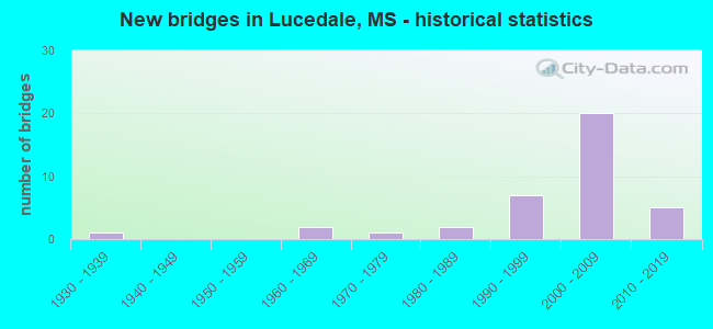
- New bridges - historical statistics
- 11930-1939
- 21960-1969
- 11970-1979
- 21980-1989
- 71990-1999
- 202000-2009
- 52010-2019


- Bridge Condition - Deck
- 33.3%Very good
- 54.2%Good
- 8.3%Satisfactory
- 4.2%Fair

- Bridge Condition - Superstructure
- 66.7%Very good
- 20.8%Good
- 8.3%Satisfactory
- 4.2%Fair

- Bridge Condition - Substructure
- 66.7%Very good
- 20.8%Good
- 8.3%Satisfactory
- 4.2%Fair

- Bridge Condition - Channel
- 5.3%Excellent
- 57.9%Very good
- 15.8%Good
- 5.3%Satisfactory
- 15.8%Fair
Find on map >> Show street view
Structure Number: 21000980202078, Location: 1.9 MI E SR 63 (Lat: 30.953636, Lng: -88.591222), Route carried "on" structure: US 98, Year Built: 1986, Status: Open, Structure Length: 1.30m (4.27ft), Average Daily Traffic: 7,800 (year 2020), Truck Traffic: 20%, Average Future Daily Traffic: 10,000 (year 2040), Design Load: HS 20+Mod, Features Intersected: BEAVERDAM CREEK
Minimum Vertical Clearance: 30+ m (98+ ft), Kilometerpoint: 11.056, Lanes on structure: 4, Base Highway Network: Yes (Inventory Route: 9, Subroute: 1), Owner: State Highway Agency, Approaching Roadway Width: 25.6m (84.0ft), Skew: 3 degrees, Material/Design: Concrete, Design/Construction: Culvert, Number Of Spans In Main Unit: 2, Length of Maximum Span: 6.3m (20.7ft)
Condition: Channel: Good, Culverts: Good, Operating Rating: 40.4 metric tons, Method Used To Determine Operating Rating: Allowable Stress (AS), Inventory Rating: 32.4 metric tons, Method Used To Determine Inventory Rating: Allowable Stress (AS), Structural Evaluation: Better than present minimum criteria, Waterway Adequacy: Equal to present desirable criteria, Approach Roadway Alignment: Equal to present desirable criteria, Designated Inspection Frequency: Every 24 months, Inspection Date: May 2020
Find on map >> Show street view
Structure Number: 21000980202098, Location: 3.9 MI E SR 63 (Lat: 30.954928, Lng: -88.558969), Route carried "on" structure: US 98, Year Built: 1986, Status: Open, Structure Length: 0.76m (2.49ft), Average Daily Traffic: 7,800 (year 2020), Truck Traffic: 20%, Average Future Daily Traffic: 10,000 (year 2040), Design Load: HS 20+Mod, Features Intersected: DENNY MILL CREEK
Minimum Vertical Clearance: 9.99m (32.78ft), Kilometerpoint: 14.175, Lanes on structure: 4, Base Highway Network: Yes (Inventory Route: 9, Subroute: 1), Owner: State Highway Agency, Approaching Roadway Width: 25.6m (84.0ft), Material/Design: Concrete, Design/Construction: Culvert, Number Of Spans In Main Unit: 2, Length of Maximum Span: 3.7m (12.1ft)
Condition: Channel: Satisfactory, Culverts: Good, Operating Rating: 58.8 metric tons, Method Used To Determine Operating Rating: Load Factor (LF), Inventory Rating: 35.2 metric tons, Method Used To Determine Inventory Rating: Load Factor (LF), Structural Evaluation: Better than present minimum criteria, Waterway Adequacy: Equal to present desirable criteria, Approach Roadway Alignment: Equal to present desirable criteria, Designated Inspection Frequency: Every 24 months, Inspection Date: May 2020
Find on map >> Show street view
Structure Number: 31000260200747, Location: SR 26 OVER SR 63 (Lat: 30.892864, Lng: -88.621050), Route carried "on" structure: State highway 26, Year Built: 1999, Status: Open, Structure Length: 9.69m (31.79ft), Average Daily Traffic: 5,700 (year 2020), Truck Traffic: 14%, Average Future Daily Traffic: 5,700 (year 2040), Design Load: HS 20, Features Intersected: SR 63
Minimum Vertical Clearance: 30+ m (98+ ft), Kilometerpoint: 26.512, Lanes on structure: 3, Lanes under structure: 4, Base Highway Network: Yes (Inventory Route: 2, Subroute: 1), Owner: State Highway Agency, Approaching Roadway Width: 17.0m (55.8ft), Material/Design: Prestressed concrete continuous, Design/Construction: Stringer/Multi-beam, Number Of Spans In Main Unit: 4, Length of Maximum Span: 27.1m (88.9ft), Curb-To-Curb Width: 15.8m (51.8ft), Out-to-Out Width: 16.7m (54.8ft)
Condition: Deck: Very good, Superstructure: Very good, Substructure: Very good, Operating Rating: 52.6 metric tons, Method Used To Determine Operating Rating: Load Factor (LF), Inventory Rating: 24.9 metric tons, Method Used To Determine Inventory Rating: Load Factor (LF), Structural Evaluation: Equal to present minimum criteria, Deck Geometry: Better than present minimum criteria, Underclear: Superior to present desirable criteria, Approach Roadway Alignment: Equal to present desirable criteria, Designated Inspection Frequency: Every 24 months, Inspection Date: May 2020, Deck Structure Type: Concrete Cast-file-Place
Find on map >> Show street view
Structure Number: 31000630200391A, Location: 0.8 MI N SR 26 (Lat: 30.905422, Lng: -88.623064), Route carried "on" structure: State highway 63, Year Built: 2000, Status: Open, Structure Length: 6.20m (20.34ft), Average Daily Traffic: 2,650 (year 2020), Truck Traffic: 16%, Average Future Daily Traffic: 3,500 (year 2040), Design Load: HS 20, Features Intersected: TAPPLEY CREEK
Minimum Vertical Clearance: 30+ m (98+ ft), Kilometerpoint: 11.161, Lanes on structure: 2, Base Highway Network: Yes (Inventory Route: 6, Subroute: 1), Owner: State Highway Agency, Approaching Roadway Width: 12.8m (42.0ft), Skew: 4 degrees, Material/Design: Prestressed concrete, Design/Construction: Stringer/Multi-beam, Number Of Spans In Main Unit: 5, Length of Maximum Span: 12.1m (39.7ft), Curb-To-Curb Width: 12.2m (40.0ft), Out-to-Out Width: 13.1m (43.0ft)
Condition: Deck: Good, Superstructure: Very good, Substructure: Very good, Channel: Very good, Operating Rating: 60.3 metric tons, Method Used To Determine Operating Rating: Load Factor (LF), Inventory Rating: 36.1 metric tons, Method Used To Determine Inventory Rating: Load Factor (LF), Structural Evaluation: Equal to present desirable criteria, Deck Geometry: Better than present minimum criteria, Waterway Adequacy: Equal to present desirable criteria, Approach Roadway Alignment: Equal to present desirable criteria, Designated Inspection Frequency: Every 24 months, Inspection Date: May 2020, Deck Structure Type: Concrete Cast-file-Place
Find on map >> Show street view
Structure Number: 31000630200391B, Location: 0.8 MI N SR 26 (Lat: 30.904786, Lng: -88.622478), Route carried "on" structure: State highway 63, Year Built: 2000, Status: Open, Structure Length: 6.16m (20.21ft), Average Daily Traffic: 2,650 (year 2020), Truck Traffic: 16%, Average Future Daily Traffic: 3,500 (year 2040), Design Load: HS 20, Features Intersected: TAPPLEY CREEK
Minimum Vertical Clearance: 30+ m (98+ ft), Kilometerpoint: 19.396, Lanes on structure: 2, Base Highway Network: Yes (Inventory Route: 6, Subroute: 1), Owner: State Highway Agency, Approaching Roadway Width: 12.8m (42.0ft), Skew: 4 degrees, Material/Design: Prestressed concrete, Design/Construction: Stringer/Multi-beam, Number Of Spans In Main Unit: 5, Length of Maximum Span: 12.1m (39.7ft), Curb-To-Curb Width: 12.2m (40.0ft), Out-to-Out Width: 13.1m (43.0ft)
Condition: Deck: Good, Superstructure: Very good, Substructure: Very good, Channel: Very good, Operating Rating: 58.0 metric tons, Method Used To Determine Operating Rating: Load Factor (LF), Inventory Rating: 34.6 metric tons, Method Used To Determine Inventory Rating: Load Factor (LF), Structural Evaluation: Equal to present desirable criteria, Deck Geometry: Better than present minimum criteria, Waterway Adequacy: Equal to present desirable criteria, Approach Roadway Alignment: Equal to present desirable criteria, Designated Inspection Frequency: Every 24 months, Inspection Date: May 2020, Deck Structure Type: Concrete Cast-file-Place
Find on map >> Show street view
Structure Number: 31000630200416A, Location: 3.3 MI N SR 26 (Lat: 30.940664, Lng: -88.626722), Route carried "on" structure: State highway 63, Year Built: 2000, Status: Open, Structure Length: 9.20m (30.18ft), Average Daily Traffic: 2,650 (year 2020), Truck Traffic: 16%, Average Future Daily Traffic: 3,500 (year 2040), Design Load: HS 20, Features Intersected: BIG CREEK
Minimum Vertical Clearance: 30+ m (98+ ft), Kilometerpoint: 7.150, Lanes on structure: 2, Base Highway Network: Yes (Inventory Route: 6, Subroute: 1), Owner: State Highway Agency, Approaching Roadway Width: 12.8m (42.0ft), Material/Design: Prestressed concrete, Design/Construction: Stringer/Multi-beam, Number Of Spans In Main Unit: 1, Number Of Approach Spans: 4, Length of Maximum Span: 24.4m (80.1ft), Curb-To-Curb Width: 12.2m (40.0ft), Out-to-Out Width: 13.1m (43.0ft)
Condition: Deck: Very good, Superstructure: Very good, Substructure: Very good, Channel: Very good, Operating Rating: 55.2 metric tons, Method Used To Determine Operating Rating: Load Factor (LF), Inventory Rating: 30.7 metric tons, Method Used To Determine Inventory Rating: Load Factor (LF), Structural Evaluation: Better than present minimum criteria, Deck Geometry: Better than present minimum criteria, Waterway Adequacy: Equal to present desirable criteria, Approach Roadway Alignment: Equal to present desirable criteria, Designated Inspection Frequency: Every 24 months, Inspection Date: May 2020, Deck Structure Type: Concrete Cast-file-Place
Find on map >> Show street view
Structure Number: 31000630200416B, Location: 3.3 MI N SR 26 (Lat: 30.939836, Lng: -88.626600), Route carried "on" structure: State highway 63, Year Built: 2000, Status: Open, Structure Length: 9.20m (30.18ft), Average Daily Traffic: 2,650 (year 2020), Truck Traffic: 16%, Average Future Daily Traffic: 3,500 (year 2040), Design Load: HS 20, Features Intersected: BIG CREEK
Minimum Vertical Clearance: 30+ m (98+ ft), Kilometerpoint: 23.390, Lanes on structure: 2, Base Highway Network: Yes (Inventory Route: 6, Subroute: 1), Owner: State Highway Agency, Approaching Roadway Width: 12.8m (42.0ft), Material/Design: Prestressed concrete, Design/Construction: Stringer/Multi-beam, Number Of Spans In Main Unit: 1, Number Of Approach Spans: 4, Length of Maximum Span: 24.4m (80.1ft), Curb-To-Curb Width: 12.2m (40.0ft), Out-to-Out Width: 13.1m (43.0ft)
Condition: Deck: Good, Superstructure: Very good, Substructure: Very good, Channel: Very good, Operating Rating: 55.2 metric tons, Method Used To Determine Operating Rating: Load Factor (LF), Inventory Rating: 30.7 metric tons, Method Used To Determine Inventory Rating: Load Factor (LF), Structural Evaluation: Better than present minimum criteria, Deck Geometry: Better than present minimum criteria, Waterway Adequacy: Equal to present desirable criteria, Approach Roadway Alignment: Equal to present desirable criteria, Designated Inspection Frequency: Every 24 months, Inspection Date: May 2020, Deck Structure Type: Concrete Cast-file-Place
Find on map >> Show street view
Structure Number: 31000630200426A, Location: 1.0 MI S US 98 (Lat: 30.943992, Lng: -88.626081), Route carried "on" structure: State highway 63, Year Built: 2000, Status: Open, Structure Length: 11.12m (36.48ft), Average Daily Traffic: 2,650 (year 2020), Truck Traffic: 16%, Average Future Daily Traffic: 3,500 (year 2040), Design Load: HS 20, Features Intersected: SR 198/CNIC RR
Minimum Vertical Clearance: 30+ m (98+ ft), Kilometerpoint: 6.775, Lanes on structure: 2, Lanes under structure: 2, Base Highway Network: Yes (Inventory Route: 6, Subroute: 1), Owner: State Highway Agency, Approaching Roadway Width: 12.8m (42.0ft), Material/Design: Prestressed concrete continuous, Design/Construction: Stringer/Multi-beam, Number Of Spans In Main Unit: 5, Length of Maximum Span: 29.2m (95.8ft), Curb-To-Curb Width: 12.2m (40.0ft), Out-to-Out Width: 13.1m (43.0ft)
Condition: Deck: Good, Superstructure: Very good, Substructure: Very good, Operating Rating: 55.1 metric tons, Method Used To Determine Operating Rating: Load Factor (LF), Inventory Rating: 25.9 metric tons, Method Used To Determine Inventory Rating: Load Factor (LF), Structural Evaluation: Equal to present minimum criteria, Deck Geometry: Better than present minimum criteria, Underclear: Superior to present desirable criteria, Approach Roadway Alignment: Equal to present desirable criteria, Designated Inspection Frequency: Every 24 months, Inspection Date: May 2020, Deck Structure Type: Concrete Cast-file-Place
Find on map >> Show street view
Structure Number: 31000630200426B, Location: 1.0 MI S US 98 (Lat: 30.942972, Lng: -88.625992), Route carried "on" structure: State highway 63, Year Built: 2000, Status: Open, Structure Length: 11.12m (36.48ft), Average Daily Traffic: 2,650 (year 2020), Truck Traffic: 16%, Average Future Daily Traffic: 3,500 (year 2040), Design Load: HS 20, Features Intersected: SR 198/CNIC RR
Minimum Vertical Clearance: 30+ m (98+ ft), Kilometerpoint: 23.744, Lanes on structure: 2, Lanes under structure: 2, Base Highway Network: Yes (Inventory Route: 6, Subroute: 1), Owner: State Highway Agency, Approaching Roadway Width: 12.8m (42.0ft), Material/Design: Prestressed concrete continuous, Design/Construction: Stringer/Multi-beam, Number Of Spans In Main Unit: 5, Length of Maximum Span: 29.2m (95.8ft), Curb-To-Curb Width: 12.2m (40.0ft), Out-to-Out Width: 13.1m (43.0ft)
Condition: Deck: Good, Superstructure: Very good, Substructure: Very good, Operating Rating: 55.1 metric tons, Method Used To Determine Operating Rating: Load Factor (LF), Inventory Rating: 25.9 metric tons, Method Used To Determine Inventory Rating: Load Factor (LF), Structural Evaluation: Equal to present minimum criteria, Deck Geometry: Better than present minimum criteria, Underclear: Better than present minimum criteria, Approach Roadway Alignment: Equal to present desirable criteria, Designated Inspection Frequency: Every 24 months, Inspection Date: May 2020, Deck Structure Type: Concrete Cast-file-Place
Find on map >> Show street view
Structure Number: 31000630200428A, Location: SR 63 OVER US 98 (Lat: 30.957994, Lng: -88.624383), Route carried "on" structure: State highway 63, Year Built: 2000, Status: Open, Structure Length: 9.75m (31.99ft), Average Daily Traffic: 2,650 (year 2020), Truck Traffic: 16%, Average Future Daily Traffic: 3,500 (year 2040), Design Load: HS 20, Features Intersected: US 98
Minimum Vertical Clearance: 30+ m (98+ ft), Kilometerpoint: 5.214, Lanes on structure: 2, Lanes under structure: 4, Base Highway Network: Yes (Inventory Route: 6, Subroute: 1), Owner: State Highway Agency, Approaching Roadway Width: 12.8m (42.0ft), Material/Design: Prestressed concrete continuous, Design/Construction: Stringer/Multi-beam, Number Of Spans In Main Unit: 2, Number Of Approach Spans: 2, Length of Maximum Span: 27.1m (88.9ft), Curb-To-Curb Width: 12.2m (40.0ft), Out-to-Out Width: 13.1m (43.0ft)
Condition: Deck: Good, Superstructure: Very good, Substructure: Very good, Operating Rating: 64.1 metric tons, Method Used To Determine Operating Rating: Load Factor (LF), Inventory Rating: 31.1 metric tons, Method Used To Determine Inventory Rating: Load Factor (LF), Structural Evaluation: Better than present minimum criteria, Deck Geometry: Better than present minimum criteria, Underclear: Equal to present desirable criteria, Approach Roadway Alignment: Equal to present desirable criteria, Designated Inspection Frequency: Every 24 months, Inspection Date: May 2020, Deck Structure Type: Concrete Cast-file-Place
Find on map >> Show street view
Structure Number: 31000630200428B, Location: SR 63 OVER US 98 (Lat: 30.957069, Lng: -88.624186), Route carried "on" structure: State highway 63, Year Built: 2000, Status: Open, Structure Length: 9.75m (31.99ft), Average Daily Traffic: 2,650 (year 2020), Truck Traffic: 16%, Average Future Daily Traffic: 3,500 (year 2040), Design Load: HS 20, Features Intersected: US 98
Minimum Vertical Clearance: 30+ m (98+ ft), Kilometerpoint: 25.317, Lanes on structure: 2, Lanes under structure: 4, Base Highway Network: Yes (Inventory Route: 6, Subroute: 1), Owner: State Highway Agency, Approaching Roadway Width: 12.8m (42.0ft), Material/Design: Prestressed concrete continuous, Design/Construction: Stringer/Multi-beam, Number Of Spans In Main Unit: 2, Number Of Approach Spans: 2, Length of Maximum Span: 27.1m (88.9ft), Curb-To-Curb Width: 12.2m (40.0ft), Out-to-Out Width: 13.1m (43.0ft)
Condition: Deck: Good, Superstructure: Very good, Substructure: Very good, Operating Rating: 64.1 metric tons, Method Used To Determine Operating Rating: Load Factor (LF), Inventory Rating: 31.1 metric tons, Method Used To Determine Inventory Rating: Load Factor (LF), Structural Evaluation: Better than present minimum criteria, Deck Geometry: Better than present minimum criteria, Underclear: Equal to present desirable criteria, Approach Roadway Alignment: Equal to present desirable criteria, Designated Inspection Frequency: Every 24 months, Inspection Date: May 2020, Deck Structure Type: Concrete Cast-file-Place
Find on map >> Show street view
Structure Number: 31000630210487A, Location: 0.9 MI N GEORGE CL (Lat: 31.007436, Lng: -88.587719), Route carried "on" structure: State highway 63, Year Built: 2011, Status: Open, Structure Length: 5.17m (16.96ft), Average Daily Traffic: 1,600 (year 2020), Truck Traffic: 10%, Average Future Daily Traffic: 1,700 (year 2040), Design Load: HS 20, Features Intersected: EVANS CREEK
Minimum Vertical Clearance: 30+ m (98+ ft), Kilometerpoint: 15.360, Lanes on structure: 2, Base Highway Network: Yes (Inventory Route: 6, Subroute: 1), Owner: State Highway Agency, Approaching Roadway Width: 12.0m (39.4ft), Material/Design: Prestressed concrete continuous, Design/Construction: Stringer/Multi-beam, Number Of Spans In Main Unit: 3, Length of Maximum Span: 17.0m (55.8ft), Curb-To-Curb Width: 12.0m (39.4ft), Out-to-Out Width: 12.9m (42.3ft)
Condition: Deck: Very good, Superstructure: Very good, Substructure: Very good, Channel: Very good, Operating Rating: 55.7 metric tons, Method Used To Determine Operating Rating: Load Factor (LF), Inventory Rating: 27.5 metric tons, Method Used To Determine Inventory Rating: Load Factor (LF), Structural Evaluation: Equal to present minimum criteria, Deck Geometry: Better than present minimum criteria, Waterway Adequacy: Equal to present desirable criteria, Approach Roadway Alignment: Equal to present desirable criteria, Designated Inspection Frequency: Every 24 months, Inspection Date: April 2020, Deck Structure Type: Concrete Cast-file-Place
Find on map >> Show street view
Structure Number: 31000630210487B, Location: 0.9 MI N GEORGE CL (Lat: 31.006897, Lng: -88.588006), Route carried "on" structure: State highway 63, Year Built: 2011, Status: Open, Structure Length: 5.17m (16.96ft), Average Daily Traffic: 1,600 (year 2020), Truck Traffic: 10%, Average Future Daily Traffic: 1,700 (year 2040), Design Load: HS 20, Features Intersected: EVANS CREEK
Minimum Vertical Clearance: 30+ m (98+ ft), Kilometerpoint: 1.463, Lanes on structure: 2, Base Highway Network: Yes (Inventory Route: 6, Subroute: 1), Owner: State Highway Agency, Approaching Roadway Width: 12.0m (39.4ft), Material/Design: Prestressed concrete continuous, Design/Construction: Stringer/Multi-beam, Number Of Spans In Main Unit: 3, Length of Maximum Span: 17.0m (55.8ft), Curb-To-Curb Width: 12.0m (39.4ft), Out-to-Out Width: 12.9m (42.3ft)
Condition: Deck: Very good, Superstructure: Very good, Substructure: Very good, Channel: Very good, Operating Rating: 55.7 metric tons, Method Used To Determine Operating Rating: Load Factor (LF), Inventory Rating: 27.5 metric tons, Method Used To Determine Inventory Rating: Load Factor (LF), Structural Evaluation: Equal to present minimum criteria, Deck Geometry: Better than present minimum criteria, Waterway Adequacy: Equal to present desirable criteria, Approach Roadway Alignment: Equal to present desirable criteria, Designated Inspection Frequency: Every 24 months, Inspection Date: April 2020, Deck Structure Type: Concrete Cast-file-Place
Find on map >> Show street view
Structure Number: 3100198020207, Location: 2.0 MI W SR 63 SOUTH (Lat: 30.941064, Lng: -88.617569), Route carried "on" structure: State highway 198, Year Built: 2012, Status: Open, Structure Length: 11.03m (36.19ft), Average Daily Traffic: 2,100 (year 2020), Truck Traffic: 5%, Average Future Daily Traffic: 2,100 (year 2040), Design Load: HS 20, Features Intersected: BIG CREEK
Minimum Vertical Clearance: 30+ m (98+ ft), Kilometerpoint: 4.712, Lanes on structure: 2, Owner: State Highway Agency, Approaching Roadway Width: 13.4m (44.0ft), Skew: 3 degrees, Material/Design: Prestressed concrete, Design/Construction: Stringer/Multi-beam, Number Of Spans In Main Unit: 1, Number Of Approach Spans: 6, Length of Maximum Span: 30.5m (100.1ft), Curb-To-Curb Width: 13.4m (44.0ft), Out-to-Out Width: 14.3m (46.9ft)
Condition: Deck: Very good, Superstructure: Very good, Substructure: Very good, Channel: Very good, Operating Rating: 61.0 metric tons, Method Used To Determine Operating Rating: Load Factor (LF), Inventory Rating: 27.5 metric tons, Method Used To Determine Inventory Rating: Load Factor (LF), Structural Evaluation: Equal to present minimum criteria, Deck Geometry: Better than present minimum criteria, Waterway Adequacy: Equal to present desirable criteria, Approach Roadway Alignment: Equal to present desirable criteria, Designated Inspection Frequency: Every 24 months, Inspection Date: May 2020, Deck Structure Type: Concrete Cast-file-Place
Find on map >> Show street view
Structure Number: 31001980202096, Location: 0.8 MI E SR 63 SOUTH (Lat: 30.924964, Lng: -88.581742), Route carried "on" structure: State highway 198, Year Built: 1999, Status: Open, Structure Length: 13.78m (45.21ft), Average Daily Traffic: 4,000 (year 2020), Truck Traffic: 14%, Average Future Daily Traffic: 4,000 (year 2040), Design Load: HS 20, Features Intersected: DEPOT CREEK/CNIC RR
Minimum Vertical Clearance: 30+ m (98+ ft), Kilometerpoint: 8.877, Lanes on structure: 2, Base Highway Network: Yes (Inventory Route: 19, Subroute: 1), Owner: State Highway Agency, Approaching Roadway Width: 14.4m (47.2ft), Skew: 3 degrees, Material/Design: Prestressed concrete continuous, Design/Construction: Stringer/Multi-beam, Number Of Spans In Main Unit: 5, Length of Maximum Span: 31.0m (101.7ft), Curb-To-Curb Width: 14.4m (47.2ft), Out-to-Out Width: 15.3m (50.2ft)
Condition: Deck: Good, Superstructure: Very good, Substructure: Very good, Channel: Good, Operating Rating: 59.6 metric tons, Method Used To Determine Operating Rating: Load Factor (LF), Inventory Rating: 23.4 metric tons, Method Used To Determine Inventory Rating: Load Factor (LF), Structural Evaluation: Equal to present minimum criteria, Deck Geometry: Superior to present desirable criteria, Underclear: Superior to present desirable criteria, Waterway Adequacy: Equal to present desirable criteria, Approach Roadway Alignment: Better than present minimum criteria, Designated Inspection Frequency: Every 24 months, Inspection Date: May 2020, Deck Structure Type: Concrete Cast-file-Place
Find on map >> Show street view
Structure Number: 31001980202126, Location: 1.0 MI W US 98 (Lat: 30.924561, Lng: -88.531517), Route carried "on" structure: State highway 198, Year Built: 2016, Status: Open, Structure Length: 7.36m (24.15ft), Average Daily Traffic: 3,500 (year 2020), Truck Traffic: 14%, Average Future Daily Traffic: 3,500 (year 2040), Design Load: HL 93, Features Intersected: ROCKY CREEK
Minimum Vertical Clearance: 30+ m (98+ ft), Kilometerpoint: 13.678, Lanes on structure: 2, Base Highway Network: Yes (Inventory Route: 19, Subroute: 1), Owner: State Highway Agency, Approaching Roadway Width: 13.4m (44.0ft), Material/Design: Prestressed concrete, Design/Construction: Stringer/Multi-beam, Number Of Spans In Main Unit: 1, Number Of Approach Spans: 4, Length of Maximum Span: 24.4m (80.1ft), Curb-To-Curb Width: 13.4m (44.0ft), Out-to-Out Width: 14.3m (46.9ft)
Condition: Deck: Very good, Superstructure: Very good, Substructure: Very good, Channel: Very good, Operating Rating: 49.7 metric tons, Method Used To Determine Operating Rating: Load and Resistance Factor (LRFR), Inventory Rating: 34.7 metric tons, Method Used To Determine Inventory Rating: Load and Resistance Factor (LRFR), Structural Evaluation: Equal to present desirable criteria, Deck Geometry: Better than present minimum criteria, Waterway Adequacy: Superior to present desirable criteria, Approach Roadway Alignment: Equal to present desirable criteria, Designated Inspection Frequency: Every 24 months, Inspection Date: May 2020, Deck Structure Type: Concrete Cast-file-Place
Find on map >> Show street view
Structure Number: 41000610142566, Location: 1.8 MI S US 49 (Lat: 34.172331, Lng: -90.578939), Route carried "on" structure: County highway , Year Built: 2003, Status: Open, Structure Length: 11.30m (37.07ft), Average Daily Traffic: 530 (year 2020), Truck Traffic: 11%, Average Future Daily Traffic: 530 (year 2040), Design Load: HS 20, Features Intersected: US 61, Facility Carried by Structure: NEW AFRICA ROAD
Minimum Vertical Clearance: 30+ m (98+ ft), Kilometerpoint: 21.211, Lanes on structure: 4, Lanes under structure: 6, Owner: State Highway Agency, Approaching Roadway Width: 19.5m (64.0ft), Skew: 2 degrees, Material/Design: Prestressed concrete continuous, Design/Construction: Stringer/Multi-beam, Number Of Spans In Main Unit: 4, Length of Maximum Span: 34.7m (113.8ft), Curb-To-Curb Width: 19.5m (64.0ft), Out-to-Out Width: 20.4m (66.9ft)
Condition: Deck: Good, Superstructure: Good, Substructure: Good, Operating Rating: 61.9 metric tons, Method Used To Determine Operating Rating: Load Factor (LF), Inventory Rating: 25.9 metric tons, Method Used To Determine Inventory Rating: Load Factor (LF), Structural Evaluation: Equal to present minimum criteria, Deck Geometry: Better than present minimum criteria, Underclear: Better than present minimum criteria, Approach Roadway Alignment: Equal to present desirable criteria, Designated Inspection Frequency: Every 24 months, Inspection Date: January 2021, Deck Structure Type: Concrete Cast-file-Place
Find on map >> Show street view
Structure Number: 41000630200401, Location: 1.7 MI N SR 26 (Lat: 30.917614, Lng: -88.628475), Route carried "on" structure: County highway , Year Built: 2000, Status: Open, Structure Length: 9.45m (31.00ft), Average Daily Traffic: 260 (year 2020), Truck Traffic: 8%, Average Future Daily Traffic: 310 (year 2040), Design Load: HS 20, Features Intersected: SR 63, Facility Carried by Structure: FIG FARM ROAD
Minimum Vertical Clearance: 30+ m (98+ ft), Kilometerpoint: 3.227, Lanes on structure: 2, Lanes under structure: 4, Owner: State Highway Agency, Approaching Roadway Width: 10.0m (32.8ft), Material/Design: Prestressed concrete continuous, Design/Construction: Stringer/Multi-beam, Number Of Spans In Main Unit: 2, Number Of Approach Spans: 2, Length of Maximum Span: 27.1m (88.9ft), Curb-To-Curb Width: 9.1m (29.9ft), Out-to-Out Width: 10.0m (32.8ft)
Condition: Deck: Very good, Superstructure: Very good, Substructure: Very good, Operating Rating: 54.0 metric tons, Method Used To Determine Operating Rating: Load Factor (LF), Inventory Rating: 29.0 metric tons, Method Used To Determine Inventory Rating: Load Factor (LF), Structural Evaluation: Better than present minimum criteria, Deck Geometry: Equal to present minimum criteria, Underclear: Equal to present desirable criteria, Approach Roadway Alignment: Equal to present desirable criteria, Designated Inspection Frequency: Every 24 months, Inspection Date: May 2020, Deck Structure Type: Concrete Cast-file-Place
Find on map >> Show street view
Structure Number: SA2000000000001, Location: SEC 6 T 1S R 4W (Lat: 30.994614, Lng: -88.425650), Route carried "on" structure: County highway 180, Year Built: 2005, Status: Open, Structure Length: 2.10m (6.89ft), Average Daily Traffic: 50 (year 2021), Truck Traffic: 10%, Average Future Daily Traffic: 100 (year 2041), Design Load: HS 20, Features Intersected: LIVE STREAM, Facility Carried by Structure: TURNER ROAD
Minimum Vertical Clearance: 30+ m (98+ ft), Kilometerpoint: 0.965, Lanes on structure: 2, Owner: County Highway Agency, Approaching Roadway Width: 8.5m (27.9ft), Material/Design: Concrete, Design/Construction: Channel Beam, Number Of Spans In Main Unit: 3, Length of Maximum Span: 9.4m (30.8ft), Curb-To-Curb Width: 8.1m (26.6ft), Out-to-Out Width: 8.6m (28.2ft)
Condition: Deck: Good, Superstructure: Good, Substructure: Good, Channel: Good, Operating Rating: 75.8 metric tons, Method Used To Determine Operating Rating: Load Factor (LF), Inventory Rating: 45.4 metric tons, Method Used To Determine Inventory Rating: Load Factor (LF), Structural Evaluation: Better than present minimum criteria, Deck Geometry: Equal to present minimum criteria, Waterway Adequacy: Superior to present desirable criteria, Approach Roadway Alignment: Equal to present minimum criteria, Designated Inspection Frequency: Every 24 months, Inspection Date: Febuary 2021, Deck Structure Type: Concrete Precast Panels
Find on map >> Show street view
Structure Number: SA2000000000007, Location: SEC 21 T 1S R 6W B (Lat: 30.948019, Lng: -88.595489), Route carried "on" structure: County highway 175, Year Built: 1974, Status: Open, Structure Length: 3.66m (12.01ft), Average Daily Traffic: 1,000 (year 2021), Truck Traffic: 10%, Average Future Daily Traffic: 1,500 (year 2041), Design Load: HS 20, Features Intersected: BEAVERDAM CREEK, Facility Carried by Structure: BEAVER DAM ROAD
Minimum Vertical Clearance: 30+ m (98+ ft), Kilometerpoint: 2.735, Lanes on structure: 2, Owner: County Highway Agency, Approaching Roadway Width: 10.7m (35.1ft), Material/Design: Concrete, Design/Construction: Channel Beam, Number Of Spans In Main Unit: 3, Length of Maximum Span: 12.2m (40.0ft), Curb-To-Curb Width: 8.6m (28.2ft), Out-to-Out Width: 9.2m (30.2ft)
Condition: Deck: Good, Superstructure: Good, Substructure: Good, Channel: Very good, Operating Rating: 75.2 metric tons, Method Used To Determine Operating Rating: Load Factor (LF), Inventory Rating: 34.3 metric tons, Method Used To Determine Inventory Rating: Load Factor (LF), Structural Evaluation: Better than present minimum criteria, Deck Geometry: Somewhat better than minimum adequacy, Waterway Adequacy: Superior to present desirable criteria, Approach Roadway Alignment: Equal to present desirable criteria, Designated Inspection Frequency: Every 24 months, Inspection Date: March 2021, Deck Structure Type: Concrete Precast Panels, Wearing Surface/Protective System: Wearing Surface: Monolithic Concrete
Find on map >> Show street view
Structure Number: SA2000000000008, Location: SEC 25 T 1S R 6W (Lat: 30.932864, Lng: -88.534694), Route carried "on" structure: County highway 19, Year Built: 1997, Status: Open, Structure Length: 0.66m (2.17ft), Average Daily Traffic: 200 (year 2021), Truck Traffic: 10%, Average Future Daily Traffic: 300 (year 2041), Design Load: HS 20, Features Intersected: CREEK, Facility Carried by Structure: OLD MOBILE HWY
Minimum Vertical Clearance: 30+ m (98+ ft), Kilometerpoint: 5.149, Lanes on structure: 2, Owner: County Highway Agency, Approaching Roadway Width: 6.0m (19.7ft), Material/Design: Concrete, Design/Construction: Culvert, Number Of Spans In Main Unit: 2, Length of Maximum Span: 3.3m (10.8ft)
Condition: Channel: Very good, Culverts: Good, Operating Rating: 57.5 metric tons, Method Used To Determine Operating Rating: Load Factor (LF), Inventory Rating: 34.7 metric tons, Method Used To Determine Inventory Rating: Load Factor (LF), Structural Evaluation: Better than present minimum criteria, Waterway Adequacy: Superior to present desirable criteria, Approach Roadway Alignment: Equal to present desirable criteria, Designated Inspection Frequency: Every 24 months, Inspection Date: March 2021
Find on map >> Show street view
Structure Number: SA2000000000009, Location: SEC 25 T 1S R 6W (Lat: 30.932272, Lng: -88.531478), Route carried "on" structure: County highway 19, Year Built: 1996, Status: Open, Structure Length: 2.10m (6.89ft), Average Daily Traffic: 200 (year 2021), Truck Traffic: 10%, Average Future Daily Traffic: 300 (year 2041), Design Load: HS 20, Features Intersected: ROCKY CREEK, Facility Carried by Structure: OLD MOBILE HWY
Minimum Vertical Clearance: 30+ m (98+ ft), Kilometerpoint: 5.471, Lanes on structure: 2, Owner: County Highway Agency, Approaching Roadway Width: 6.1m (20.0ft), Material/Design: Concrete, Design/Construction: Channel Beam, Number Of Spans In Main Unit: 3, Length of Maximum Span: 9.4m (30.8ft), Curb-To-Curb Width: 7.3m (24.0ft), Out-to-Out Width: 7.8m (25.6ft)
Condition: Deck: Good, Superstructure: Good, Substructure: Good, Channel: Very good, Operating Rating: 70.6 metric tons, Method Used To Determine Operating Rating: Load Factor (LF), Inventory Rating: 42.2 metric tons, Method Used To Determine Inventory Rating: Load Factor (LF), Structural Evaluation: Better than present minimum criteria, Deck Geometry: Somewhat better than minimum adequacy, Waterway Adequacy: Superior to present desirable criteria, Approach Roadway Alignment: Equal to present desirable criteria, Designated Inspection Frequency: Every 24 months, Inspection Date: March 2021, Deck Structure Type: Concrete Precast Panels, Wearing Surface/Protective System: Wearing Surface: Monolithic Concrete
Find on map >> Show street view
Structure Number: SA200000000001, Location: SEC 28 T 1S R 6W (Lat: 30.928475, Lng: -88.583019), Route carried "on" structure: County highway 19, Year Built: 1996, Status: Open, Structure Length: 2.10m (6.89ft), Average Daily Traffic: 770 (year 2021), Truck Traffic: 10%, Average Future Daily Traffic: 1,300 (year 2041), Design Load: HS 20, Features Intersected: BIG CREEK, Facility Carried by Structure: DEPOT ROAD
Minimum Vertical Clearance: 30+ m (98+ ft), Kilometerpoint: 0.482, Lanes on structure: 2, Owner: County Highway Agency, Approaching Roadway Width: 6.1m (20.0ft), Material/Design: Concrete, Design/Construction: Channel Beam, Number Of Spans In Main Unit: 3, Length of Maximum Span: 9.4m (30.8ft), Curb-To-Curb Width: 8.1m (26.6ft), Out-to-Out Width: 8.6m (28.2ft)
Condition: Deck: Good, Superstructure: Good, Substructure: Good, Channel: Excellent, Operating Rating: 75.8 metric tons, Method Used To Determine Operating Rating: Load Factor (LF), Inventory Rating: 45.4 metric tons, Method Used To Determine Inventory Rating: Load Factor (LF), Structural Evaluation: Better than present minimum criteria, Deck Geometry: Somewhat better than minimum adequacy, Waterway Adequacy: Equal to present desirable criteria, Approach Roadway Alignment: Equal to present desirable criteria, Designated Inspection Frequency: Every 24 months, Inspection Date: March 2021, Deck Structure Type: Concrete Precast Panels, Wearing Surface/Protective System: Wearing Surface: Monolithic Concrete
Find on map >> Show street view
Structure Number: SA2000000000011, Location: SEC 28 T 1S R 6W B (Lat: 30.934094, Lng: -88.591225), Route carried "on" structure: City street 175, Year Built: 1965, Status: Open, Structure Length: 1.74m (5.71ft), Average Daily Traffic: 1,000 (year 2021), Truck Traffic: 10%, Average Future Daily Traffic: 1,500 (year 2041), Design Load: HS 20, Features Intersected: BIG CREEK, Facility Carried by Structure: BEAVER DAM ROAD
Minimum Vertical Clearance: 30+ m (98+ ft), Kilometerpoint: 1.126, Lanes on structure: 2, Owner: County Highway Agency, Approaching Roadway Width: 10.7m (35.1ft), Material/Design: Concrete, Design/Construction: Slab, Number Of Spans In Main Unit: 3, Length of Maximum Span: 5.8m (19.0ft), Curb-To-Curb Width: 8.6m (28.2ft), Out-to-Out Width: 9.2m (30.2ft)
Condition: Deck: Fair, Superstructure: Fair, Substructure: Satisfactory, Channel: Fair, Operating Rating: 41.5 metric tons, Method Used To Determine Operating Rating: Load Factor (LF), Inventory Rating: 24.8 metric tons, Method Used To Determine Inventory Rating: Load Factor (LF), Structural Evaluation: Somewhat better than minimum adequacy, Deck Geometry: Somewhat better than minimum adequacy, Waterway Adequacy: Superior to present desirable criteria, Approach Roadway Alignment: Equal to present desirable criteria, Length Of Structure Improvement: 2.61m (8.56ft), Designated Inspection Frequency: Every 24 months, Inspection Date: March 2021, Bridge Improvement Cost: $600,000, Roadway Improvement Cost: $100,000, Total Project Cost: $900,000 ( Estimate for 2021), Deck Structure Type: Concrete Cast-file-Place, Wearing Surface/Protective System: Wearing Surface: Monolithic Concrete
Find on map >> Show street view
Structure Number: SA2000000000014, Location: SEC 11 T 1S R 7W (Lat: 30.968761, Lng: -88.652747), Route carried "on" structure: County highway 36, Year Built: 2008, Status: Open, Structure Length: 1.74m (5.71ft), Average Daily Traffic: 25 (year 2021), Truck Traffic: 2%, Average Future Daily Traffic: 30 (year 2041), Design Load: H 15, Features Intersected: LIVE STREAM, Facility Carried by Structure: C.F. EUBANKS RD
Minimum Vertical Clearance: 30+ m (98+ ft), Kilometerpoint: 0.804, Lanes on structure: 2, Owner: County Highway Agency, Approaching Roadway Width: 6.1m (20.0ft), Material/Design: Concrete, Design/Construction: Channel Beam, Number Of Spans In Main Unit: 3, Length of Maximum Span: 5.8m (19.0ft), Curb or Sidewalk Widths: Left: 0.2m (0.7ft), Right: 0.2m (0.7ft), Curb-To-Curb Width: 7.1m (23.3ft), Out-to-Out Width: 7.6m (24.9ft)
Condition: Deck: Satisfactory, Superstructure: Satisfactory, Substructure: Satisfactory, Channel: Fair, Operating Rating: 38.0 metric tons, Method Used To Determine Operating Rating: Load Factor (LF), Inventory Rating: 22.8 metric tons, Method Used To Determine Inventory Rating: Load Factor (LF), Structural Evaluation: Equal to present minimum criteria, Deck Geometry: Somewhat better than minimum adequacy, Waterway Adequacy: Superior to present desirable criteria, Approach Roadway Alignment: Equal to present desirable criteria, Length Of Structure Improvement: 1.74m (5.71ft), Designated Inspection Frequency: Every 24 months, Inspection Date: December 2020, Bridge Improvement Cost: $115,000, Roadway Improvement Cost: $52,000, Total Project Cost: $167,000, Deck Structure Type: Concrete Precast Panels, Wearing Surface/Protective System: Wearing Surface: Monolithic Concrete
Find on map >> Show street view
Structure Number: SA2000000000031, Location: SEC 6 T 2S R 6W B (Lat: 30.906975, Lng: -88.631119), Route carried "on" structure: County highway 174, Year Built: 1965, Status: Posted for load, Structure Length: 1.74m (5.71ft), Average Daily Traffic: 450 (year 2021), Truck Traffic: 10%, Average Future Daily Traffic: 675 (year 2041), Design Load: H 15, Features Intersected: TOPPLEY BRANCH, Facility Carried by Structure: FIG FARM ROAD
Minimum Vertical Clearance: 30+ m (98+ ft), Kilometerpoint: 1.770, Lanes on structure: 2, Owner: County Highway Agency, Approaching Roadway Width: 6.5m (21.3ft), Material/Design: Concrete, Design/Construction: Slab, Number Of Spans In Main Unit: 3, Length of Maximum Span: 5.8m (19.0ft), Curb or Sidewalk Widths: Left: 0.4m (1.3ft), Right: 0.4m (1.3ft), Curb-To-Curb Width: 6.8m (22.3ft), Out-to-Out Width: 7.6m (24.9ft)
Condition: Deck: Satisfactory, Superstructure: Satisfactory, Substructure: Fair, Channel: Fair, Operating Rating: 31.6 metric tons, Method Used To Determine Operating Rating: Load Factor (LF), Inventory Rating: 18.9 metric tons, Method Used To Determine Inventory Rating: Load Factor (LF), Structural Evaluation: Somewhat better than minimum adequacy, Deck Geometry: Meets minimum limits, Waterway Adequacy: Superior to present desirable criteria, Approach Roadway Alignment: Equal to present desirable criteria, Bridge Posting: Required (Relationship of Operating Rating to Maximum Legal Load: 10.0 - 19.9% below), Length Of Structure Improvement: 2.10m (6.89ft), Designated Inspection Frequency: Every 24 months, Inspection Date: December 2020, Bridge Improvement Cost: $242,000, Roadway Improvement Cost: $125,000, Total Project Cost: $367,000 ( Estimate for 2014), Deck Structure Type: Concrete Cast-file-Place, Wearing Surface/Protective System: Wearing Surface: Monolithic Concrete
Find on map >> Show street view
Structure Number: SA200000000A015, Location: SEC 13 T 1S R 7W B (Lat: 30.955567, Lng: -88.638564), Route carried "on" structure: County highway , Year Built: 2015, Status: Open, Structure Length: 4.88m (16.01ft), Average Daily Traffic: 400 (year 2019), Truck Traffic: 20%, Average Future Daily Traffic: 2,039 (year 0520), Design Load: HL 93, Features Intersected: RAILROAD TRACK, Facility Carried by Structure: ERNEST PIPKINS RD
Minimum Vertical Clearance: 30+ m (98+ ft), Kilometerpoint: 965.000, Lanes on structure: 2, Owner: County Highway Agency, Approaching Roadway Width: 9.8m (32.2ft), Material/Design: Prestressed concrete, Design/Construction: Stringer/Multi-beam, Number Of Spans In Main Unit: 3, Length of Maximum Span: 24.4m (80.1ft), Curb-To-Curb Width: 8.5m (27.9ft), Out-to-Out Width: 9.4m (30.8ft)
Condition: Deck: Very good, Superstructure: Very good, Substructure: Very good, Operating Rating: 48.9 metric tons, Method Used To Determine Operating Rating: Load and Resistance Factor Rating (LRFR) rating reported by rating factor(RF) method using HL-93 loadings, Inventory Rating: 28.2 metric tons, Method Used To Determine Inventory Rating: Load and Resistance Factor Rating (LRFR) rating reported by rating factor(RF) method using HL-93 loadings, Structural Evaluation: Better than present minimum criteria, Deck Geometry: Equal to present minimum criteria, Underclear: Superior to present desirable criteria, Approach Roadway Alignment: Better than present minimum criteria, Designated Inspection Frequency: Every 24 months, Inspection Date: December 2019, Deck Structure Type: Concrete Cast-file-Place
Find on map >> Show street view
Structure Number: 21000980202047, Location: 3.0 MI W OF LUCEDALE (Lat: 30.954839, Lng: -88.650833), Route carried "under" structure: State highway 198, Year Built: 1938, Structure Length: 0. m, Average Daily Traffic: 2,100 (year 2018), Truck Traffic: 8%, Features Intersected: SR 198, Facility Carried by Structure: CNIC RR
Minimum Vertical Clearance: 4.60m (15.09ft), Kilometerpoint: 1.334, Lanes under structure: 2, Material/Design: Steel, Design/Construction: Stringer/Multi-beam, Length of Maximum Span: 14.0m (45.9ft)
Find on map >> Show street view
Structure Number: 31000260200747, Location: SR 26 OVER SR 63 (Lat: 30.892939, Lng: -88.620419), Route carried "under" structure: State highway 63, Year Built: 1999, Structure Length: 0. m, Average Daily Traffic: 4,400 (year 2018), Truck Traffic: 8%, Features Intersected: SR 63, Facility Carried by Structure: SR 26
Minimum Vertical Clearance: 5.66m (18.57ft), Kilometerpoint: 18.062, Lanes on structure: 3, Lanes under structure: 4, Material/Design: Prestressed concrete continuous, Design/Construction: Stringer/Multi-beam, Length of Maximum Span: 27.1m (88.9ft)
Find on map >> Show street view
Structure Number: 31000260200747, Location: SR 26 OVER SR 63 (Lat: 30.892911, Lng: -88.620700), Route carried "under" structure: State highway 63, Year Built: 1999, Structure Length: 0. m, Average Daily Traffic: 4,400 (year 2018), Truck Traffic: 8%, Features Intersected: SR 63, Facility Carried by Structure: SR 26
Minimum Vertical Clearance: 5.84m (19.16ft), Kilometerpoint: 12.574, Lanes on structure: 3, Lanes under structure: 4, Material/Design: Prestressed concrete continuous, Design/Construction: Stringer/Multi-beam, Length of Maximum Span: 27.1m (88.9ft)
Find on map >> Show street view
Structure Number: 31000630200426A, Location: 1.0 MI S US 98 (Lat: 30.943331, Lng: -88.626211), Route carried "under" structure: State highway 198, Year Built: 2000, Structure Length: 0. m, Average Daily Traffic: 2,100 (year 2018), Truck Traffic: 3%, Features Intersected: SR 198/CNIC RR, Facility Carried by Structure: SR 63
Minimum Vertical Clearance: 8.81m (28.90ft), Kilometerpoint: 3.843, Lanes on structure: 2, Lanes under structure: 2, Material/Design: Prestressed concrete continuous, Design/Construction: Stringer/Multi-beam, Length of Maximum Span: 29.3m (96.1ft)
Find on map >> Show street view
Structure Number: 31000630200426B, Location: 1.0 MI S US 98 (Lat: 30.943281, Lng: -88.625931), Route carried "under" structure: State highway 198, Year Built: 2000, Structure Length: 0. m, Average Daily Traffic: 2,400 (year 2018), Truck Traffic: 3%, Features Intersected: SR 198/CNIC RR, Facility Carried by Structure: SR 63
Minimum Vertical Clearance: 8.78m (28.81ft), Kilometerpoint: 3.870, Lanes on structure: 2, Lanes under structure: 2, Material/Design: Prestressed concrete continuous, Design/Construction: Stringer/Multi-beam, Length of Maximum Span: 29.3m (96.1ft)
Find on map >> Show street view
Structure Number: 31000630200428A, Location: SR 63 OVER US 98 (Lat: 30.957661, Lng: -88.624419), Route carried "under" structure: US 98, Year Built: 2000, Structure Length: 0. m, Average Daily Traffic: 4,400 (year 2018), Truck Traffic: 10%, Features Intersected: US 98, Facility Carried by Structure: SR 63
Minimum Vertical Clearance: 5.25m (17.22ft), Kilometerpoint: 22.949, Lanes on structure: 2, Lanes under structure: 4, Material/Design: Prestressed concrete continuous, Design/Construction: Stringer/Multi-beam, Length of Maximum Span: 27.1m (88.9ft)
Find on map >> Show street view
Structure Number: 31000630200428A, Location: SR 63 OVER US 98 (Lat: 30.957411, Lng: -88.624439), Route carried "under" structure: US 98, Year Built: 2000, Structure Length: 0. m, Average Daily Traffic: 4,400 (year 2018), Truck Traffic: 10%, Features Intersected: US 98, Facility Carried by Structure: SR 63
Minimum Vertical Clearance: 5.19m (17.03ft), Kilometerpoint: 7.828, Lanes on structure: 2, Lanes under structure: 4, Material/Design: Prestressed concrete continuous, Design/Construction: Stringer/Multi-beam, Length of Maximum Span: 27.1m (88.9ft)
Find on map >> Show street view
Structure Number: 31000630200428B, Location: SR 63 OVER US 98 (Lat: 30.957600, Lng: -88.624131), Route carried "under" structure: US 98, Year Built: 2000, Structure Length: 0. m, Average Daily Traffic: 3,200 (year 2017), Truck Traffic: 10%, Features Intersected: US 98, Facility Carried by Structure: SR 63
Minimum Vertical Clearance: 5.37m (17.62ft), Kilometerpoint: 22.922, Lanes on structure: 2, Lanes under structure: 4, Material/Design: Prestressed concrete continuous, Design/Construction: Stringer/Multi-beam, Length of Maximum Span: 27.1m (88.9ft)
Find on map >> Show street view
Structure Number: 31000630200428B, Location: SR 63 OVER US 98 (Lat: 30.957361, Lng: -88.624161), Route carried "under" structure: US 98, Year Built: 2000, Structure Length: 0. m, Average Daily Traffic: 3,200 (year 2017), Truck Traffic: 10%, Features Intersected: US 98, Facility Carried by Structure: SR 63
Minimum Vertical Clearance: 5.29m (17.36ft), Kilometerpoint: 7.855, Lanes on structure: 2, Lanes under structure: 4, Material/Design: Prestressed concrete continuous, Design/Construction: Stringer/Multi-beam, Length of Maximum Span: 27.1m (88.9ft)
Find on map >> Show street view
Structure Number: 41000630200401, Location: 1.7 MI N SR 26 (Lat: 30.917611, Lng: -88.628131), Route carried "under" structure: State highway 63, Year Built: 2000, Structure Length: 0. m, Average Daily Traffic: 5,600 (year 2017), Truck Traffic: 8%, Features Intersected: SR 63, Facility Carried by Structure: FIG FARM ROAD
Minimum Vertical Clearance: 5.41m (17.75ft), Kilometerpoint: 9.716, Lanes on structure: 2, Lanes under structure: 4, Material/Design: Prestressed concrete continuous, Design/Construction: Stringer/Multi-beam, Length of Maximum Span: 27.1m (88.9ft)
Find on map >> Show street view
Structure Number: 41000630200401, Location: 1.7 MI N SR 26 (Lat: 30.917611, Lng: -88.627850), Route carried "under" structure: State highway 63, Year Built: 2000, Structure Length: 0. m, Average Daily Traffic: 5,600 (year 2017), Truck Traffic: 8%, Features Intersected: SR 63, Facility Carried by Structure: FIG FARM ROAD
Minimum Vertical Clearance: 5.54m (18.18ft), Kilometerpoint: 20.918, Lanes on structure: 2, Lanes under structure: 4, Material/Design: Prestressed concrete continuous, Design/Construction: Stringer/Multi-beam, Length of Maximum Span: 27.1m (88.9ft)