Bridge Statistics for Ludington, Michigan (MI)
Condition, Traffic, Stress, Structural Evaluation, Project Costs
- National Bridge Inventory (NBI) Statistics
- 37Number of bridges
- 440ft / 134mTotal length
- $349,000Total costs
- 148,852Total average daily traffic
- 13,566Total average daily truck traffic
- National Bridge Inventory (NBI) Registered Bridges for Ludington
- No street view available for this location
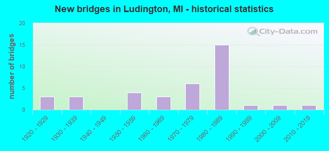
- New bridges - historical statistics
- 31920-1929
- 31930-1939
- 41950-1959
- 31960-1969
- 61970-1979
- 151980-1989
- 11990-1999
- 12000-2009
- 12010-2019
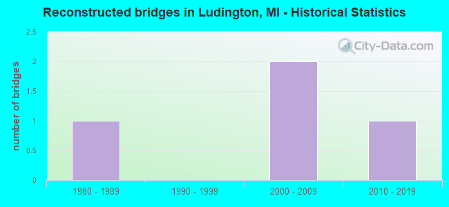
- Reconstructed bridges - Historical Statistics
- 11980-1989
- 01990-1999
- 22000-2009
- 12010-2019
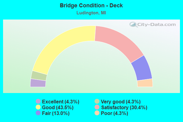
- Bridge Condition - Deck
- 4.3%Excellent
- 4.3%Very good
- 43.5%Good
- 30.4%Satisfactory
- 13.0%Fair
- 4.3%Poor
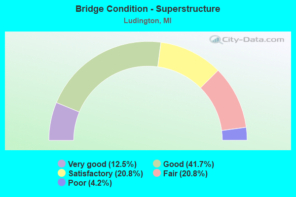
- Bridge Condition - Superstructure
- 12.5%Very good
- 41.7%Good
- 20.8%Satisfactory
- 20.8%Fair
- 4.2%Poor
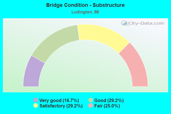
- Bridge Condition - Substructure
- 16.7%Very good
- 29.2%Good
- 29.2%Satisfactory
- 25.0%Fair
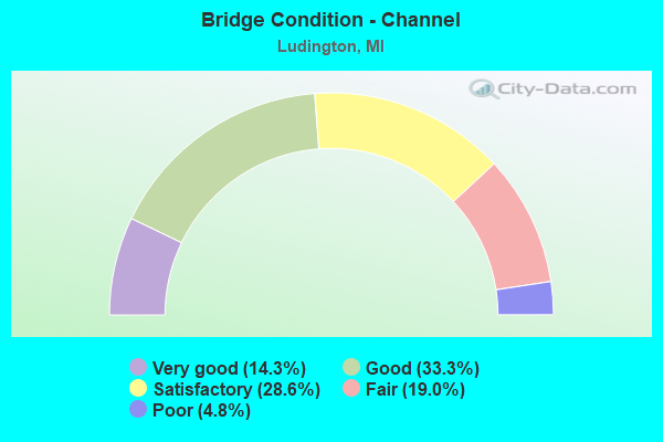
- Bridge Condition - Channel
- 14.3%Very good
- 33.3%Good
- 28.6%Satisfactory
- 19.0%Fair
- 4.8%Poor
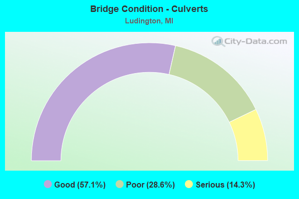
- Bridge Condition - Culverts
- 57.1%Good
- 28.6%Poor
- 14.3%Serious
Find on map >> Show street view
Structure Number: 13, Location: 1 MI N 6.5 MI W OF SPRUCE (Lat: 44.859072, Lng: -83.595258), Route carried "on" structure: County highway , Year Built: 1955, Status: Open, Structure Length: 1.98m (6.50ft), Average Daily Traffic: 1,730 (year 2003), Average Future Daily Traffic: 2,375 (year 2023), Features Intersected: THUNDER BAY RIVER, Facility Carried by Structure: HURBERT ROAD
Minimum Vertical Clearance: 30.48m (100.00ft), Kilometerpoint: 2.614, Lanes on structure: 2, Owner: County Highway Agency, Approaching Roadway Width: 10.1m (33.1ft), Material/Design: Steel, Design/Construction: Culvert, Number Of Spans In Main Unit: 5, Length of Maximum Span: 3.9m (12.8ft), Curb-To-Curb Width: 10.1m (33.1ft), Out-to-Out Width: 11.2m (36.7ft)
Condition: Channel: Fair, Culverts: Poor, Operating Rating: 97.2 metric tons, Method Used To Determine Operating Rating: Load Factor (LF) rating reported by rating factor (RF) method using MS18 loading, Inventory Rating: 71.0 metric tons, Method Used To Determine Inventory Rating: Load Factor (LF) rating reported by rating factor (RF) method using MS18 loading, Structural Evaluation: Meets minimum limits, Deck Geometry: Somewhat better than minimum adequacy, Waterway Adequacy: Better than present minimum criteria, Approach Roadway Alignment: Equal to present desirable criteria, Length Of Structure Improvement: 3.05m (10.01ft), Designated Inspection Frequency: Every 12 months, Inspection Date: May 2021, Bridge Improvement Cost: $675,000, Roadway Improvement Cost: $80,000, Total Project Cost: $90,000
Find on map >> Show street view
Structure Number: 202, Location: JUST SOUTH OF 102ND AVE (Lat: 42.433186, Lng: -85.744758), Route carried "on" structure: County highway 306, Year Built: 1968, Status: Open, Structure Length: 1.22m (4.00ft), Average Daily Traffic: 1,565 (year 2003), Truck Traffic: 7%, Average Future Daily Traffic: 3,130 (year 2023), Design Load: HS 20+Mod, Features Intersected: PINE CREEK, Facility Carried by Structure: 21ST STREET
Minimum Vertical Clearance: 30.48m (100.00ft), Kilometerpoint: 0.557, Lanes on structure: 2, Owner: County Highway Agency, Approaching Roadway Width: 10.4m (34.1ft), Material/Design: Wood or Timber, Design/Construction: Slab, Number Of Spans In Main Unit: 2, Length of Maximum Span: 6.1m (20.0ft), Curb-To-Curb Width: 8.5m (27.9ft), Out-to-Out Width: 9.1m (29.9ft)
Condition: Deck: Satisfactory, Superstructure: Satisfactory, Substructure: Fair, Channel: Fair, Operating Rating: 54.8 metric tons, Method Used To Determine Operating Rating: Allowable Stress (AS) rating reported by rating factor (RF) method using MS18 loading, Inventory Rating: 38.6 metric tons, Method Used To Determine Inventory Rating: Allowable Stress (AS) rating reported by rating factor (RF) method using MS18 loading, Structural Evaluation: Somewhat better than minimum adequacy, Deck Geometry: Somewhat better than minimum adequacy, Waterway Adequacy: Equal to present minimum criteria, Approach Roadway Alignment: Equal to present minimum criteria, Designated Inspection Frequency: Every 24 months, Inspection Date: September 2021, Deck Structure Type: Wood or Timber, Wearing Surface/Protective System: Wearing Surface: Bituminous
Find on map >> Show street view
Structure Number: 213, Location: APPROX 1/4MI N OF 104TH A (Lat: 42.450233, Lng: -86.158319), Route carried "on" structure: County highway , Year Built: 1973, Status: Posted for load, Structure Length: 0.77m (2.53ft), Average Daily Traffic: 32 (year 2002), Truck Traffic: 7%, Average Future Daily Traffic: 64 (year 2022), Design Load: H 20, Features Intersected: SPICEBUSH CREEK, Facility Carried by Structure: 63RD STREET
Minimum Vertical Clearance: 30.48m (100.00ft), Kilometerpoint: 3.455, Lanes on structure: 2, Owner: County Highway Agency, Approaching Roadway Width: 6.7m (22.0ft), Skew: 2 degrees, Material/Design: Steel, Design/Construction: Culvert, Number Of Spans In Main Unit: 2, Length of Maximum Span: 3.0m (9.8ft)
Condition: Channel: Satisfactory, Culverts: Serious, Operating Rating: 33.0 metric tons, Method Used To Determine Operating Rating: Load Factor (LF) rating reported by rating factor (RF) method using MS18 loading, Inventory Rating: 19.8 metric tons, Method Used To Determine Inventory Rating: Load Factor (LF) rating reported by rating factor (RF) method using MS18 loading, Structural Evaluation: High priority of corrective action, Waterway Adequacy: Somewhat better than minimum adequacy, Approach Roadway Alignment: Equal to present minimum criteria, Bridge Posting: Required (Relationship of Operating Rating to Maximum Legal Load: > 39.9% below), Designated Inspection Frequency: Every 12 months, Inspection Date: April 2021
Find on map >> Show street view
Structure Number: 241, Location: APPROX 1/8MI W OF 50TH ST (Lat: 42.740167, Lng: -86.039686), Route carried "on" structure: County highway , Year Built: 1984, Status: Open, Structure Length: 1.11m (3.64ft), Average Daily Traffic: 147 (year 2002), Truck Traffic: 7%, Average Future Daily Traffic: 294 (year 2022), Design Load: H 20, Features Intersected: S BR MACATAWA RIVER, Facility Carried by Structure: 144TH AVE
Minimum Vertical Clearance: 30.48m (100.00ft), Kilometerpoint: 0.652, Lanes on structure: 2, Owner: County Highway Agency, Approaching Roadway Width: 9.1m (29.9ft), Material/Design: Steel, Design/Construction: Culvert, Number Of Spans In Main Unit: 2, Length of Maximum Span: 5.0m (16.4ft)
Condition: Channel: Fair, Culverts: Poor, Operating Rating: 22.7 metric tons, Method Used To Determine Operating Rating: Load Factor (LF) rating reported by rating factor (RF) method using MS18 loading, Inventory Rating: 13.6 metric tons, Method Used To Determine Inventory Rating: Load Factor (LF) rating reported by rating factor (RF) method using MS18 loading, Structural Evaluation: Meets minimum limits, Waterway Adequacy: Equal to present desirable criteria, Approach Roadway Alignment: Equal to present minimum criteria, Designated Inspection Frequency: Every 12 months, Inspection Date: May 2021
Find on map >> Show street view
Structure Number: 669, Location: 2.0 MI W OF BAY CITY (Lat: 43.595633, Lng: -83.952292), Route carried "on" structure: County highway 2008, Year Built: 1958, Status: Open, Structure Length: 6.61m (21.69ft), Average Daily Traffic: 4,626 (year 1997), Truck Traffic: 3%, Average Future Daily Traffic: 2,555 (year 1977), Design Load: H 15, Features Intersected: US-10, Facility Carried by Structure: THREE MILE RD
Minimum Vertical Clearance: 30.48m (100.00ft), Kilometerpoint: 4.416, Lanes on structure: 2, Lanes under structure: 5, Owner: State Highway Agency, Approaching Roadway Width: 11.8m (38.7ft), Material/Design: Concrete continuous, Design/Construction: Tee Beam, Number Of Spans In Main Unit: 4, Length of Maximum Span: 19.5m (64.0ft), Curb or Sidewalk Widths: Left: 0.7m (2.3ft), Right: 0.7m (2.3ft), Curb-To-Curb Width: 7.9m (25.9ft), Out-to-Out Width: 10.1m (33.1ft)
Condition: Deck: Fair, Superstructure: Fair, Substructure: Satisfactory, Operating Rating: 59.0 metric tons, Method Used To Determine Operating Rating: Load Factor (LF) rating reported by rating factor (RF) method using MS18 loading, Inventory Rating: 34.0 metric tons, Method Used To Determine Inventory Rating: Load Factor (LF) rating reported by rating factor (RF) method using MS18 loading, Structural Evaluation: Somewhat better than minimum adequacy, Deck Geometry: High priority of corrective action, Underclear: High priority of corrective action, Approach Roadway Alignment: Equal to present minimum criteria, Designated Inspection Frequency: Every 24 months, Inspection Date: December 2021, Bridge Improvement Cost: $77,000, Roadway Improvement Cost: $8,000, Total Project Cost: $91,000, Deck Structure Type: Concrete Cast-file-Place, Wearing Surface/Protective System: Wearing Surface: Monolithic Concrete
Find on map >> Show street view
Structure Number: 1298, Location: ATHENS TWP SEC 21 (Lat: 42.110553, Lng: -85.252539), Route carried "on" structure: County highway 1312, Year Built: 1957, Status: Posted for load, Structure Length: 1.52m (4.99ft), Average Daily Traffic: 865 (year 1995), Truck Traffic: 14%, Average Future Daily Traffic: 1,548 (year 2023), Design Load: H 15, Features Intersected: PINE CREEK, Facility Carried by Structure: S DR SO
Minimum Vertical Clearance: 30.48m (100.00ft), Kilometerpoint: 1.053, Lanes on structure: 2, Owner: County Highway Agency, Approaching Roadway Width: 8.2m (26.9ft), Material/Design: Concrete, Design/Construction: Tee Beam, Number Of Spans In Main Unit: 1, Length of Maximum Span: 15.2m (49.9ft), Curb or Sidewalk Widths: Left: 0.4m (1.3ft), Right: 0.4m (1.3ft), Curb-To-Curb Width: 7.3m (24.0ft), Out-to-Out Width: 9.0m (29.5ft)
Condition: Deck: Good, Superstructure: Fair, Substructure: Fair, Channel: Fair, Operating Rating: 18.5 metric tons, Method Used To Determine Operating Rating: Load Factor (LF) rating reported by rating factor (RF) method using MS18 loading, Inventory Rating: 11.0 metric tons, Method Used To Determine Inventory Rating: Load Factor (LF) rating reported by rating factor (RF) method using MS18 loading, Structural Evaluation: High priority of corrective action, Deck Geometry: Meets minimum limits, Waterway Adequacy: Equal to present desirable criteria, Approach Roadway Alignment: Equal to present minimum criteria, Bridge Posting: Required (Relationship of Operating Rating to Maximum Legal Load: > 39.9% below), Designated Inspection Frequency: Every 24 months, Inspection Date: September 2021, Deck Structure Type: Concrete Cast-file-Place, Wearing Surface/Protective System: Wearing Surface: Monolithic Concrete
Find on map >> Show street view
Structure Number: 1299, Location: HOMER TWP SEC 8 (Lat: 42.130167, Lng: -84.796283), Route carried "on" structure: County highway 1316, Year Built: 1973, Year Reconstructed: 2019, Status: Open, Structure Length: 0.97m (3.18ft), Average Daily Traffic: 681 (year 1995), Truck Traffic: 14%, Average Future Daily Traffic: 1,219 (year 2023), Design Load: HL 93, Features Intersected: LAMPSON RUN, Facility Carried by Structure: P DRIVE SOUTH
Minimum Vertical Clearance: 30.48m (100.00ft), Kilometerpoint: 2.525, Lanes on structure: 2, Owner: County Highway Agency, Approaching Roadway Width: 7.9m (25.9ft), Material/Design: Wood or Timber, Design/Construction: Slab, Number Of Spans In Main Unit: 1, Length of Maximum Span: 9.7m (31.8ft), Curb-To-Curb Width: 4.7m (15.4ft), Out-to-Out Width: 9.8m (32.2ft)
Condition: Deck: Very good, Superstructure: Very good, Substructure: Satisfactory, Channel: Good, Operating Rating: 47.6 metric tons, Method Used To Determine Operating Rating: Load and Resistance Factor Rating (LRFR) rating reported by rating factor(RF) method using HL-93 loadings, Inventory Rating: 36.6 metric tons, Method Used To Determine Inventory Rating: Load and Resistance Factor Rating (LRFR) rating reported by rating factor(RF) method using HL-93 loadings, Structural Evaluation: Equal to present minimum criteria, Deck Geometry: High priority of replacement, Waterway Adequacy: Equal to present desirable criteria, Approach Roadway Alignment: Equal to present desirable criteria, Designated Inspection Frequency: Every 24 months, Inspection Date: July 2021, Deck Structure Type: Wood or Timber, Wearing Surface/Protective System: Wearing Surface: Bituminous
Find on map >> Show street view
Structure Number: 1301, Location: ALBION TWP SEC 32 (Lat: 42.159369, Lng: -84.805103), Route carried "on" structure: County highway , Year Built: 1960, Status: Posted for load, Structure Length: 2.74m (8.99ft), Average Daily Traffic: 1,130 (year 1995), Truck Traffic: 14%, Average Future Daily Traffic: 2,022 (year 2023), Design Load: H 15, Features Intersected: S BR KALAMAZOO RIVER, Facility Carried by Structure: L DR SO
Minimum Vertical Clearance: 30.48m (100.00ft), Kilometerpoint: 12.993, Lanes on structure: 2, Owner: County Highway Agency, Approaching Roadway Width: 8.5m (27.9ft), Material/Design: Prestressed concrete, Design/Construction: Box Beam or Girders - Multiple, Number Of Spans In Main Unit: 2, Length of Maximum Span: 13.7m (44.9ft), Curb or Sidewalk Widths: Left: 0.6m (2.0ft), Right: 0.6m (2.0ft), Curb-To-Curb Width: 7.9m (25.9ft), Out-to-Out Width: 9.7m (31.8ft)
Condition: Deck: Fair, Superstructure: Poor, Substructure: Satisfactory, Channel: Good, Operating Rating: 34.3 metric tons, Method Used To Determine Operating Rating: Load Factor (LF) rating reported by rating factor (RF) method using MS18 loading, Inventory Rating: 20.4 metric tons, Method Used To Determine Inventory Rating: Load Factor (LF) rating reported by rating factor (RF) method using MS18 loading, Structural Evaluation: Meets minimum limits, Deck Geometry: Meets minimum limits, Waterway Adequacy: Equal to present desirable criteria, Approach Roadway Alignment: Equal to present desirable criteria, Bridge Posting: Required (Relationship of Operating Rating to Maximum Legal Load: > 39.9% below), Designated Inspection Frequency: Every 12 months, Inspection Date: September 2021, Deck Structure Type: Concrete Precast Panels, Wearing Surface/Protective System: Wearing Surface: Bituminous
Find on map >> Show street view
Structure Number: 1545, Location: SEC 3 T34N R1E (Lat: 45.364339, Lng: -84.298322), Route carried "on" structure: County highway , Year Built: 1991, Status: Open, Structure Length: 3.26m (10.70ft), Average Daily Traffic: 420 (year 2005), Average Future Daily Traffic: 750 (year 2025), Design Load: HS 20+Mod, Features Intersected: BLACK RIVER, Facility Carried by Structure: BARCLAY AVE
Minimum Vertical Clearance: 30.48m (100.00ft), Kilometerpoint: 1.043, Lanes on structure: 2, Owner: County Highway Agency, Approaching Roadway Width: 9.1m (29.9ft), Skew: 4 degrees, Material/Design: Prestressed concrete, Design/Construction: Box Beam or Girders - Multiple, Number Of Spans In Main Unit: 3, Length of Maximum Span: 10.6m (34.8ft), Curb-To-Curb Width: 9.1m (29.9ft), Out-to-Out Width: 9.4m (30.8ft)
Condition: Deck: Poor, Superstructure: Good, Substructure: Satisfactory, Channel: Satisfactory, Operating Rating: 52.8 metric tons, Method Used To Determine Operating Rating: Load and Resistance Factor Rating (LRFR) rating reported by rating factor(RF) method using HL-93 loadings, Inventory Rating: 40.8 metric tons, Method Used To Determine Inventory Rating: Load and Resistance Factor Rating (LRFR) rating reported by rating factor(RF) method using HL-93 loadings, Structural Evaluation: Equal to present minimum criteria, Deck Geometry: Equal to present minimum criteria, Waterway Adequacy: Better than present minimum criteria, Approach Roadway Alignment: Better than present minimum criteria, Designated Inspection Frequency: Every 12 months, Inspection Date: July 2021, Deck Structure Type: Concrete Cast-file-Place, Wearing Surface/Protective System: Wearing Surface: Monolithic Concrete, Deck Protection: Epoxy Coated Reinforcing
Find on map >> Show street view
Structure Number: 2311, Location: 2.1 MI W OF INGHAM CO LIN (Lat: 42.670336, Lng: -84.644550), Route carried "on" structure: Interstate 96, Year Built: 1962, Status: Open, Structure Length: 9.22m (30.25ft), Average Daily Traffic: 21,057 (year 2007), Truck Traffic: 16%, Average Future Daily Traffic: 24,047 (year 2018), Design Load: HS 20+Mod, Features Intersected: GRAND RIV & BILLWOOD HWY
Minimum Vertical Clearance: 30.48m (100.00ft), Kilometerpoint: 11.739, Lanes on structure: 2, Lanes under structure: 2, Base Highway Network: Yes (Inventory Route: 56, Subroute: 6), Owner: State Highway Agency, Approaching Roadway Width: 12.8m (42.0ft), Material/Design: Steel, Design/Construction: Stringer/Multi-beam, Number Of Spans In Main Unit: 3, Length of Maximum Span: 33.5m (109.9ft), Curb-To-Curb Width: 9.9m (32.5ft), Out-to-Out Width: 10.8m (35.4ft)
Condition: Deck: Satisfactory, Superstructure: Fair, Substructure: Satisfactory, Channel: Good, Operating Rating: 62.2 metric tons, Method Used To Determine Operating Rating: Load Factor (LF) rating reported by rating factor (RF) method using MS18 loading, Inventory Rating: 37.3 metric tons, Method Used To Determine Inventory Rating: Load Factor (LF) rating reported by rating factor (RF) method using MS18 loading, Structural Evaluation: Somewhat better than minimum adequacy, Deck Geometry: Meets minimum limits, Underclear: Somewhat better than minimum adequacy, Waterway Adequacy: Equal to present desirable criteria, Approach Roadway Alignment: Equal to present desirable criteria, Designated Inspection Frequency: Every 24 months, Critical Feature Inspection Frequency: Every 15 months, Inspection Date: July 2021, Critical Feature Inspection Date: April 2021, Deck Structure Type: Concrete Cast-file-Place, Wearing Surface/Protective System: Wearing Surface: Integral Concrete, Deck Protection: Epoxy Coated Reinforcing
Find on map >> Show street view
Structure Number: 2411, Location: 3 MI SE OF SUNFIELD (Lat: 42.726653, Lng: -84.960950), Route carried "on" structure: County highway , Year Built: 1989, Status: Open, Structure Length: 0.70m (2.30ft), Average Daily Traffic: 299 (year 2010), Average Future Daily Traffic: 500 (year 2013), Design Load: HS 20, Features Intersected: WINCHELL & UNION DRAIN, Facility Carried by Structure: ST JOE HWY
Minimum Vertical Clearance: 30.48m (100.00ft), Kilometerpoint: 7.876, Lanes on structure: 2, Owner: County Highway Agency, Approaching Roadway Width: 9.0m (29.5ft), Skew: 4 degrees, Material/Design: Steel, Design/Construction: Culvert, Number Of Spans In Main Unit: 1, Length of Maximum Span: 7.0m (23.0ft)
Condition: Channel: Very good, Culverts: Good, Operating Rating: 68.0 metric tons, Method Used To Determine Operating Rating: Load Factor (LF) rating reported by rating factor (RF) method using MS18 loading, Inventory Rating: 64.2 metric tons, Method Used To Determine Inventory Rating: Load Factor (LF) rating reported by rating factor (RF) method using MS18 loading, Structural Evaluation: Better than present minimum criteria, Waterway Adequacy: Equal to present desirable criteria, Approach Roadway Alignment: Equal to present desirable criteria, Designated Inspection Frequency: Every 24 months, Inspection Date: April 2021
Find on map >> Show street view
Structure Number: 6631, Location: 0.6 MI N OF LUDINGTON (Lat: 43.978392, Lng: -86.459500), Route carried "on" structure: State highway 116, Year Built: 1934, Year Reconstructed: 1993, Status: Open, Structure Length: 4.66m (15.29ft), Average Daily Traffic: 4,764 (year 2007), Truck Traffic: 2%, Average Future Daily Traffic: 7,929 (year 2018), Design Load: HS 25 or greater, Features Intersected: LINCOLN RIVER
Minimum Vertical Clearance: 30.48m (100.00ft), Kilometerpoint: 2.794, Lanes on structure: 2, Owner: State Highway Agency, Approaching Roadway Width: 11.0m (36.1ft), Material/Design: Prestressed concrete, Design/Construction: Box Beam or Girders - Multiple, Number Of Spans In Main Unit: 3, Length of Maximum Span: 15.5m (50.9ft), Curb-To-Curb Width: 13.4m (44.0ft), Out-to-Out Width: 14.3m (46.9ft)
Condition: Deck: Good, Superstructure: Satisfactory, Substructure: Fair, Channel: Satisfactory, Operating Rating: 70.5 metric tons, Method Used To Determine Operating Rating: Load Factor (LF), Inventory Rating: 42.2 metric tons, Method Used To Determine Inventory Rating: Load Factor (LF), Structural Evaluation: Somewhat better than minimum adequacy, Deck Geometry: Better than present minimum criteria, Waterway Adequacy: Equal to present desirable criteria, Approach Roadway Alignment: Equal to present desirable criteria, Designated Inspection Frequency: Every 24 months, Underwater Inspection Frequency: Every 60 months, Inspection Date: May 2020, Underwater Inspection Date: June 2020, Bridge Improvement Cost: $61,000, Deck Structure Type: Concrete Cast-file-Place, Wearing Surface/Protective System: Wearing Surface: Epoxy Overlay, Deck Protection: Epoxy Coated Reinforcing
Find on map >> Show street view
Structure Number: 6636, Location: 2.3 MI S OF US-10 (Lat: 43.928181, Lng: -86.417622), Route carried "on" structure: Alternate US 31, Year Built: 1924, Year Reconstructed: 2000, Status: Open, Structure Length: 2.29m (7.51ft), Average Daily Traffic: 6,828 (year 2007), Truck Traffic: 7%, Average Future Daily Traffic: 8,942 (year 2018), Design Load: H 15, Features Intersected: PERE MARQUETTE RIVER
Minimum Vertical Clearance: 30.48m (100.00ft), Kilometerpoint: 12.890, Lanes on structure: 2, Base Highway Network: Yes (Inventory Route: 21, Subroute: 4), Owner: State Highway Agency, Approaching Roadway Width: 12.2m (40.0ft), Skew: 2 degrees, Material/Design: Prestressed concrete, Design/Construction: Box Beam or Girders - Multiple, Number Of Spans In Main Unit: 1, Length of Maximum Span: 22.6m (74.1ft), Curb-To-Curb Width: 11.6m (38.1ft), Out-to-Out Width: 12.5m (41.0ft)
Condition: Superstructure: Good, Substructure: Very good, Channel: Good, Operating Rating: 87.5 metric tons, Method Used To Determine Operating Rating: Load Factor (LF) rating reported by rating factor (RF) method using MS18 loading, Inventory Rating: 50.2 metric tons, Method Used To Determine Inventory Rating: Load Factor (LF) rating reported by rating factor (RF) method using MS18 loading, Structural Evaluation: Better than present minimum criteria, Deck Geometry: Somewhat better than minimum adequacy, Waterway Adequacy: Equal to present desirable criteria, Approach Roadway Alignment: Equal to present minimum criteria, Designated Inspection Frequency: Every 24 months, Inspection Date: May 2020, Deck Structure Type: Concrete Cast-file-Place, Wearing Surface/Protective System: Wearing Surface: Epoxy Overlay, Deck Protection: Epoxy Coated Reinforcing
Find on map >> Show street view
Structure Number: 6637, Location: 1.9 MI S OF US-10 (Lat: 43.932597, Lng: -86.417272), Route carried "on" structure: Alternate US 31, Year Built: 1925, Year Reconstructed: 2000, Status: Open, Structure Length: 2.29m (7.51ft), Average Daily Traffic: 7,076 (year 2007), Truck Traffic: 5%, Average Future Daily Traffic: 11,830 (year 2018), Design Load: H 15, Features Intersected: PERE MARQUETTE RIVER
Minimum Vertical Clearance: 30.48m (100.00ft), Kilometerpoint: 13.382, Lanes on structure: 2, Base Highway Network: Yes (Inventory Route: 21, Subroute: 4), Owner: State Highway Agency, Approaching Roadway Width: 12.2m (40.0ft), Material/Design: Prestressed concrete, Design/Construction: Box Beam or Girders - Multiple, Number Of Spans In Main Unit: 1, Length of Maximum Span: 22.6m (74.1ft), Curb-To-Curb Width: 11.6m (38.1ft), Out-to-Out Width: 12.5m (41.0ft)
Condition: Deck: Good, Superstructure: Good, Substructure: Very good, Channel: Good, Operating Rating: 81.3 metric tons, Method Used To Determine Operating Rating: Load Factor (LF) rating reported by rating factor (RF) method using MS18 loading, Inventory Rating: 48.0 metric tons, Method Used To Determine Inventory Rating: Load Factor (LF) rating reported by rating factor (RF) method using MS18 loading, Structural Evaluation: Better than present minimum criteria, Deck Geometry: Somewhat better than minimum adequacy, Waterway Adequacy: Equal to present minimum criteria, Approach Roadway Alignment: Somewhat better than minimum adequacy, Designated Inspection Frequency: Every 24 months, Inspection Date: May 2020, Deck Structure Type: Concrete Cast-file-Place, Wearing Surface/Protective System: Wearing Surface: Epoxy Overlay, Deck Protection: Epoxy Coated Reinforcing
Find on map >> Show street view
Structure Number: 6639, Location: 0.4 MI S OF US-10 (Lat: 43.950325, Lng: -86.415714), Route carried "on" structure: Alternate US 31, Year Built: 1935, Year Reconstructed: 2021, Status: Open, Structure Length: 5.09m (16.70ft), Average Daily Traffic: 11,200 (year 2021), Truck Traffic: 4%, Average Future Daily Traffic: 12,375 (year 2041), Design Load: HS 25 or greater, Features Intersected: CSX RR
Minimum Vertical Clearance: 30.48m (100.00ft), Kilometerpoint: 15.363, Lanes on structure: 2, Owner: State Highway Agency, Approaching Roadway Width: 12.8m (42.0ft), Skew: 1 degrees, Material/Design: Steel, Design/Construction: Stringer/Multi-beam, Number Of Spans In Main Unit: 4, Length of Maximum Span: 15.8m (51.8ft), Curb-To-Curb Width: 13.7m (44.9ft), Out-to-Out Width: 14.8m (48.6ft)
Condition: Deck: Excellent, Superstructure: Very good, Substructure: Satisfactory, Operating Rating: 65.8 metric tons, Method Used To Determine Operating Rating: Load Factor (LF) rating reported by rating factor (RF) method using MS18 loading, Inventory Rating: 39.2 metric tons, Method Used To Determine Inventory Rating: Load Factor (LF) rating reported by rating factor (RF) method using MS18 loading, Structural Evaluation: Equal to present minimum criteria, Deck Geometry: Superior to present desirable criteria, Approach Roadway Alignment: Somewhat better than minimum adequacy, Designated Inspection Frequency: Every 4 months, Inspection Date: December 2021, Bridge Improvement Cost: $67,000, Deck Structure Type: Concrete Cast-file-Place, Wearing Surface/Protective System: Wearing Surface: Monolithic Concrete, Deck Protection: Epoxy Coated Reinforcing
Find on map >> Show street view
Structure Number: 6645, Location: 3.6 MI SE OF LUDINGTON (Lat: 43.927319, Lng: -86.383822), Route carried "on" structure: US 31, Year Built: 1989, Status: Open, Structure Length: 12.19m (39.99ft), Average Daily Traffic: 2,498 (year 2007), Truck Traffic: 15%, Average Future Daily Traffic: 3,385 (year 2018), Design Load: HS 25 or greater, Features Intersected: PERE MARQUETTE RIVER
Minimum Vertical Clearance: 30.48m (100.00ft), Kilometerpoint: 14.414, Lanes on structure: 2, Base Highway Network: Yes (Inventory Route: 190, Subroute: 9), Owner: State Highway Agency, Approaching Roadway Width: 14.6m (47.9ft), Material/Design: Steel continuous, Design/Construction: Stringer/Multi-beam, Number Of Spans In Main Unit: 3, Length of Maximum Span: 46.3m (151.9ft), Curb-To-Curb Width: 13.4m (44.0ft), Out-to-Out Width: 14.6m (47.9ft)
Condition: Deck: Satisfactory, Superstructure: Satisfactory, Substructure: Very good, Channel: Satisfactory, Operating Rating: 68.7 metric tons, Method Used To Determine Operating Rating: Load Factor (LF) rating reported by rating factor (RF) method using MS18 loading, Inventory Rating: 41.1 metric tons, Method Used To Determine Inventory Rating: Load Factor (LF) rating reported by rating factor (RF) method using MS18 loading, Structural Evaluation: Equal to present minimum criteria, Deck Geometry: Superior to present desirable criteria, Waterway Adequacy: Equal to present desirable criteria, Approach Roadway Alignment: Equal to present desirable criteria, Designated Inspection Frequency: Every 24 months, Inspection Date: May 2020, Deck Structure Type: Concrete Cast-file-Place, Wearing Surface/Protective System: Wearing Surface: Monolithic Concrete, Deck Protection: Epoxy Coated Reinforcing
Find on map >> Show street view
Structure Number: 6647, Location: 3.1 MI E OF LUDINGTON (Lat: 43.951369, Lng: -86.384561), Route carried "on" structure: US 31, Year Built: 1988, Status: Open, Structure Length: 4.29m (14.07ft), Average Daily Traffic: 2,498 (year 2007), Truck Traffic: 15%, Average Future Daily Traffic: 3,385 (year 2018), Design Load: HS 25 or greater, Features Intersected: CSX RR
Minimum Vertical Clearance: 30.48m (100.00ft), Kilometerpoint: 17.085, Lanes on structure: 2, Base Highway Network: Yes (Inventory Route: 190, Subroute: 9), Owner: State Highway Agency, Approaching Roadway Width: 18.3m (60.0ft), Material/Design: Prestressed concrete, Design/Construction: Stringer/Multi-beam, Number Of Spans In Main Unit: 3, Length of Maximum Span: 14.3m (46.9ft), Curb-To-Curb Width: 19.2m (63.0ft), Out-to-Out Width: 20.1m (65.9ft)
Condition: Deck: Good, Superstructure: Good, Substructure: Good, Operating Rating: 81.3 metric tons, Method Used To Determine Operating Rating: Load Factor (LF) rating reported by rating factor (RF) method using MS18 loading, Inventory Rating: 48.6 metric tons, Method Used To Determine Inventory Rating: Load Factor (LF) rating reported by rating factor (RF) method using MS18 loading, Structural Evaluation: Better than present minimum criteria, Deck Geometry: Superior to present desirable criteria, Approach Roadway Alignment: Equal to present desirable criteria, Designated Inspection Frequency: Every 24 months, Inspection Date: April 2020, Deck Structure Type: Concrete Cast-file-Place, Wearing Surface/Protective System: Wearing Surface: Monolithic Concrete, Deck Protection: Epoxy Coated Reinforcing
Find on map >> Show street view
Structure Number: 6648, Location: 3.1 MI E OF LUDINGTON (Lat: 43.951358, Lng: -86.385100), Route carried "on" structure: US 31, Year Built: 1988, Status: Open, Structure Length: 4.29m (14.07ft), Average Daily Traffic: 2,498 (year 2007), Truck Traffic: 15%, Average Future Daily Traffic: 3,385 (year 2018), Design Load: HS 25 or greater, Features Intersected: CSX RR
Minimum Vertical Clearance: 30.48m (100.00ft), Kilometerpoint: 17.063, Lanes on structure: 2, Base Highway Network: Yes (Inventory Route: 190, Subroute: 10), Owner: State Highway Agency, Approaching Roadway Width: 17.1m (56.1ft), Material/Design: Prestressed concrete, Design/Construction: Stringer/Multi-beam, Number Of Spans In Main Unit: 3, Length of Maximum Span: 14.3m (46.9ft), Curb-To-Curb Width: 16.5m (54.1ft), Out-to-Out Width: 17.6m (57.7ft)
Condition: Deck: Good, Superstructure: Satisfactory, Substructure: Good, Operating Rating: 69.3 metric tons, Method Used To Determine Operating Rating: Load Factor (LF) rating reported by rating factor (RF) method using MS18 loading, Inventory Rating: 42.1 metric tons, Method Used To Determine Inventory Rating: Load Factor (LF) rating reported by rating factor (RF) method using MS18 loading, Structural Evaluation: Equal to present minimum criteria, Deck Geometry: Superior to present desirable criteria, Underclear: High priority of corrective action, Approach Roadway Alignment: Equal to present desirable criteria, Designated Inspection Frequency: Every 24 months, Inspection Date: April 2020, Deck Structure Type: Concrete Cast-file-Place, Wearing Surface/Protective System: Wearing Surface: Monolithic Concrete, Deck Protection: Epoxy Coated Reinforcing
Find on map >> Show street view
Structure Number: 6651, Location: 3.6 MI S OF LUDINGTON (Lat: 43.906269, Lng: -86.417003), Route carried "on" structure: County highway 5324, Year Built: 1986, Status: Open, Structure Length: 9.32m (30.58ft), Average Daily Traffic: 1,500 (year 1982), Average Future Daily Traffic: 1,500 (year 1977), Design Load: HS 25 or greater, Features Intersected: US-31, Facility Carried by Structure: CHAUVEZ RD
Minimum Vertical Clearance: 30.48m (100.00ft), Kilometerpoint: 2.211, Lanes on structure: 2, Lanes under structure: 4, Owner: State Highway Agency, Approaching Roadway Width: 14.6m (47.9ft), Material/Design: Prestressed concrete, Design/Construction: Stringer/Multi-beam, Number Of Spans In Main Unit: 4, Length of Maximum Span: 34.4m (112.9ft), Curb-To-Curb Width: 11.5m (37.7ft), Out-to-Out Width: 12.5m (41.0ft)
Condition: Deck: Good, Superstructure: Good, Substructure: Good, Operating Rating: 48.3 metric tons, Method Used To Determine Operating Rating: Load Factor (LF) rating reported by rating factor (RF) method using MS18 loading, Inventory Rating: 27.9 metric tons, Method Used To Determine Inventory Rating: Load Factor (LF) rating reported by rating factor (RF) method using MS18 loading, Structural Evaluation: Better than present minimum criteria, Deck Geometry: Equal to present minimum criteria, Underclear: Superior to present desirable criteria, Approach Roadway Alignment: Equal to present desirable criteria, Designated Inspection Frequency: Every 24 months, Inspection Date: April 2020, Deck Structure Type: Concrete Cast-file-Place, Wearing Surface/Protective System: Wearing Surface: Monolithic Concrete, Deck Protection: Epoxy Coated Reinforcing
Find on map >> Show street view
Structure Number: 6652, Location: 3.5 MI SE OF LUDINGTON (Lat: 43.915183, Lng: -86.403114), Route carried "on" structure: US 31, Year Built: 1986, Status: Open, Structure Length: 3.44m (11.29ft), Average Daily Traffic: 4,256 (year 2007), Truck Traffic: 15%, Average Future Daily Traffic: 3,385 (year 2018), Design Load: HS 25 or greater, Features Intersected: OLD US-31
Minimum Vertical Clearance: 30.48m (100.00ft), Kilometerpoint: 12.196, Lanes on structure: 2, Lanes under structure: 2, Base Highway Network: Yes (Inventory Route: 190, Subroute: 9), Owner: State Highway Agency, Approaching Roadway Width: 13.7m (44.9ft), Material/Design: Steel, Design/Construction: Stringer/Multi-beam, Number Of Spans In Main Unit: 1, Length of Maximum Span: 34.4m (112.9ft), Curb-To-Curb Width: 13.6m (44.6ft), Out-to-Out Width: 14.6m (47.9ft)
Condition: Deck: Good, Superstructure: Good, Substructure: Good, Operating Rating: 73.9 metric tons, Method Used To Determine Operating Rating: Load Factor (LF) rating reported by rating factor (RF) method using MS18 loading, Inventory Rating: 44.1 metric tons, Method Used To Determine Inventory Rating: Load Factor (LF) rating reported by rating factor (RF) method using MS18 loading, Structural Evaluation: Better than present minimum criteria, Deck Geometry: Superior to present desirable criteria, Underclear: Meets minimum limits, Approach Roadway Alignment: Equal to present desirable criteria, Designated Inspection Frequency: Every 24 months, Inspection Date: April 2020, Deck Structure Type: Concrete Cast-file-Place, Wearing Surface/Protective System: Wearing Surface: Epoxy Overlay, Deck Protection: Epoxy Coated Reinforcing
Find on map >> Show street view
Structure Number: 6653, Location: 3.5 MI SE OF LUDINGTON (Lat: 43.915428, Lng: -86.403483), Route carried "on" structure: US 31, Year Built: 1986, Status: Open, Structure Length: 2.83m (9.28ft), Average Daily Traffic: 4,256 (year 2007), Truck Traffic: 15%, Average Future Daily Traffic: 3,385 (year 2018), Design Load: HS 25 or greater, Features Intersected: OLD US-31
Minimum Vertical Clearance: 30.48m (100.00ft), Kilometerpoint: 12.204, Lanes on structure: 2, Lanes under structure: 4, Base Highway Network: Yes (Inventory Route: 190, Subroute: 10), Owner: State Highway Agency, Approaching Roadway Width: 14.6m (47.9ft), Material/Design: Steel, Design/Construction: Stringer/Multi-beam, Number Of Spans In Main Unit: 1, Length of Maximum Span: 28.3m (92.8ft), Curb-To-Curb Width: 13.6m (44.6ft), Out-to-Out Width: 14.6m (47.9ft)
Condition: Deck: Satisfactory, Superstructure: Good, Substructure: Good, Operating Rating: 74.5 metric tons, Method Used To Determine Operating Rating: Load Factor (LF) rating reported by rating factor (RF) method using MS18 loading, Inventory Rating: 44.7 metric tons, Method Used To Determine Inventory Rating: Load Factor (LF) rating reported by rating factor (RF) method using MS18 loading, Structural Evaluation: Better than present minimum criteria, Deck Geometry: Superior to present desirable criteria, Underclear: Meets minimum limits, Approach Roadway Alignment: Equal to present desirable criteria, Designated Inspection Frequency: Every 24 months, Inspection Date: April 2020, Deck Structure Type: Concrete Cast-file-Place, Wearing Surface/Protective System: Wearing Surface: Monolithic Concrete, Deck Protection: Epoxy Coated Reinforcing
Find on map >> Show street view
Structure Number: 6654, Location: 3.4 MI E OF LUDINGTON (Lat: 43.934436, Lng: -86.383686), Route carried "on" structure: County highway , Year Built: 1987, Status: Open, Structure Length: 8.96m (29.40ft), Average Daily Traffic: 420 (year 1978), Average Future Daily Traffic: 420 (year 1977), Design Load: HS 20, Features Intersected: US-31, Facility Carried by Structure: CONRAD RD
Minimum Vertical Clearance: 30.48m (100.00ft), Kilometerpoint: 2.908, Lanes on structure: 2, Lanes under structure: 4, Owner: State Highway Agency, Approaching Roadway Width: 14.6m (47.9ft), Material/Design: Steel continuous, Design/Construction: Stringer/Multi-beam, Number Of Spans In Main Unit: 2, Length of Maximum Span: 45.1m (148.0ft), Curb-To-Curb Width: 10.9m (35.8ft), Out-to-Out Width: 11.9m (39.0ft)
Condition: Deck: Satisfactory, Superstructure: Good, Substructure: Good, Operating Rating: 69.3 metric tons, Method Used To Determine Operating Rating: Load Factor (LF) rating reported by rating factor (RF) method using MS18 loading, Inventory Rating: 41.5 metric tons, Method Used To Determine Inventory Rating: Load Factor (LF) rating reported by rating factor (RF) method using MS18 loading, Structural Evaluation: Better than present minimum criteria, Deck Geometry: Equal to present minimum criteria, Underclear: Better than present minimum criteria, Approach Roadway Alignment: Equal to present desirable criteria, Designated Inspection Frequency: Every 24 months, Inspection Date: April 2020, Deck Structure Type: Concrete Cast-file-Place, Wearing Surface/Protective System: Wearing Surface: Epoxy Overlay, Deck Protection: Epoxy Coated Reinforcing
Find on map >> Show street view
Structure Number: 666, Location: 4 MI S OF LUDINGTON (Lat: 43.893122, Lng: -86.442533), Route carried "on" structure: County highway 5317, Year Built: 1970, Status: Open, Structure Length: 26.58m (87.20ft), Average Daily Traffic: 1,400 (year 1997), Truck Traffic: 10%, Average Future Daily Traffic: 2,000 (year 2017), Design Load: HS 20+Mod, Features Intersected: PUMPED STORAGE PENSTOCKS, Facility Carried by Structure: LAKESHORE DRIVE
Minimum Vertical Clearance: 30.48m (100.00ft), Kilometerpoint: 7.196, Lanes on structure: 2, Owner: County Highway Agency, Approaching Roadway Width: 11.5m (37.7ft), Material/Design: Steel, Design/Construction: Stringer/Multi-beam, Number Of Spans In Main Unit: 8, Length of Maximum Span: 33.2m (108.9ft), Curb or Sidewalk Widths: Left: 0.9m (3.0ft), Right: 0.9m (3.0ft), Curb-To-Curb Width: 9.1m (29.9ft), Out-to-Out Width: 11.7m (38.4ft)
Condition: Deck: Good, Superstructure: Good, Substructure: Good, Operating Rating: 60.0 metric tons, Method Used To Determine Operating Rating: Allowable Stress (AS), Inventory Rating: 34.5 metric tons, Method Used To Determine Inventory Rating: Allowable Stress (AS), Structural Evaluation: Better than present minimum criteria, Deck Geometry: Somewhat better than minimum adequacy, Approach Roadway Alignment: Equal to present minimum criteria, Designated Inspection Frequency: Every 24 months, Inspection Date: September 2020, Deck Structure Type: Concrete Cast-file-Place, Wearing Surface/Protective System: Wearing Surface: Bituminous
Find on map >> Show street view
Structure Number: 6675, Location: 5 MI N OF LUDINGTON (Lat: 44.028217, Lng: -86.456447), Route carried "on" structure: County highway , Year Built: 1970, Status: Open, Structure Length: 0.70m (2.30ft), Average Daily Traffic: 3,000 (year 1997), Truck Traffic: 10%, Average Future Daily Traffic: 3,500 (year 2017), Design Load: HS 20+Mod, Features Intersected: M BAYOU HAMLIN LAKE, Facility Carried by Structure: LAKESHORE DRIVE
Minimum Vertical Clearance: 30.48m (100.00ft), Kilometerpoint: 8.412, Lanes on structure: 2, Owner: County Highway Agency, Approaching Roadway Width: 8.8m (28.9ft), Material/Design: Steel, Design/Construction: Stringer/Multi-beam, Number Of Spans In Main Unit: 1, Length of Maximum Span: 6.4m (21.0ft), Curb-To-Curb Width: 9.8m (32.2ft), Out-to-Out Width: 9.8m (32.2ft)
Condition: Deck: Fair, Superstructure: Fair, Substructure: Fair, Channel: Very good, Operating Rating: 71.6 metric tons, Method Used To Determine Operating Rating: Load Factor (LF) rating reported by rating factor (RF) method using MS18 loading, Inventory Rating: 42.8 metric tons, Method Used To Determine Inventory Rating: Load Factor (LF) rating reported by rating factor (RF) method using MS18 loading, Structural Evaluation: Somewhat better than minimum adequacy, Deck Geometry: Meets minimum limits, Waterway Adequacy: Equal to present desirable criteria, Approach Roadway Alignment: Somewhat better than minimum adequacy, Designated Inspection Frequency: Every 24 months, Inspection Date: August 2020, Deck Structure Type: Corrugated Steel, Wearing Surface/Protective System: Wearing Surface: Bituminous
Find on map >> Show street view
Structure Number: 669, Location: IN LUDINGTON (Lat: 43.947614, Lng: -86.439406), Route carried "on" structure: City street , Year Built: 2013, Status: Open, Structure Length: 6.43m (21.10ft), Average Daily Traffic: 6,340 (year 2012), Truck Traffic: 23%, Average Future Daily Traffic: 7,010 (year 2032), Design Load: Greater than HL93, Features Intersected: PERE MARQUETTE LK BAYOU, Facility Carried by Structure: WASHINGTON AVE
Minimum Vertical Clearance: 30.48m (100.00ft), Kilometerpoint: 0.718, Lanes on structure: 2, Owner: City or Municipal Highway Agency, Approaching Roadway Width: 7.9m (25.9ft), Navigation Control: Yes ( Vertical Clearance: 2.5m (8.2ft), Horizontal Clearance: 20.9m (68.6ft)), Material/Design: Prestressed concrete, Design/Construction: Box Beam or Girders - Single/Spread, Number Of Spans In Main Unit: 3, Length of Maximum Span: 20.8m (68.2ft), Curb or Sidewalk Widths: Left: 3.0m (9.8ft), Right: 1.8m (5.9ft), Curb-To-Curb Width: 7.9m (25.9ft), Out-to-Out Width: 13.7m (44.9ft)
Condition: Deck: Good, Superstructure: Very good, Substructure: Very good, Channel: Very good, Operating Rating: 81.0 metric tons, Method Used To Determine Operating Rating: Load and Resistance Factor Rating (LRFR) rating reported by rating factor(RF) method using HL-93 loadings, Inventory Rating: 62.5 metric tons, Method Used To Determine Inventory Rating: Load and Resistance Factor Rating (LRFR) rating reported by rating factor(RF) method using HL-93 loadings, Structural Evaluation: Equal to present desirable criteria, Deck Geometry: High priority of corrective action, Waterway Adequacy: Equal to present desirable criteria, Approach Roadway Alignment: Equal to present desirable criteria, Designated Inspection Frequency: Every 24 months, Inspection Date: September 2021, Deck Structure Type: Concrete Cast-file-Place, Wearing Surface/Protective System: Wearing Surface: Monolithic Concrete, Deck Protection: Epoxy Coated Reinforcing
Find on map >> Show street view
Structure Number: 6829, Location: 5.5 MI. W OF LONGRIE (Lat: 45.420697, Lng: -87.842411), Route carried "on" structure: County highway , Year Built: 1927, Status: Open, Structure Length: 1.22m (4.00ft), Average Daily Traffic: 165 (year 1998), Truck Traffic: 2%, Average Future Daily Traffic: 190 (year 2019), Features Intersected: LONG LAKE, Facility Carried by Structure: COUNTY ROAD 352
Minimum Vertical Clearance: 30.48m (100.00ft), Kilometerpoint: 0.686, Lanes on structure: 2, Owner: County Highway Agency, Approaching Roadway Width: 7.0m (23.0ft), Material/Design: Steel, Design/Construction: Culvert, Number Of Spans In Main Unit: 6, Length of Maximum Span: 1.8m (5.9ft)
Condition: Channel: Good, Culverts: Good, Operating Rating: 54.0 metric tons, Method Used To Determine Operating Rating: Load Factor (LF), Inventory Rating: 32.4 metric tons, Method Used To Determine Inventory Rating: Load Factor (LF), Structural Evaluation: Better than present minimum criteria, Waterway Adequacy: Meets minimum limits, Approach Roadway Alignment: Meets minimum limits, Length Of Structure Improvement: 1.22m (4.00ft), Designated Inspection Frequency: Every 24 months, Inspection Date: June 2021, Bridge Improvement Cost: $100,000, Roadway Improvement Cost: $10,000, Total Project Cost: $118,000
Find on map >> Show street view
Structure Number: 8327, Location: 1.5 MI S OF ROTHBURY (Lat: 43.477594, Lng: -86.347358), Route carried "on" structure: US 31, Year Built: 1974, Status: Open, Structure Length: 3.35m (10.99ft), Average Daily Traffic: 6,360 (year 2007), Truck Traffic: 9%, Average Future Daily Traffic: 7,766 (year 2018), Design Load: HS 25 or greater, Features Intersected: OCEANA DRIVE (OLD US-31)
Minimum Vertical Clearance: 30.48m (100.00ft), Kilometerpoint: 0.975, Lanes on structure: 2, Lanes under structure: 2, Base Highway Network: Yes (Inventory Route: 154, Subroute: 2), Owner: State Highway Agency, Approaching Roadway Width: 13.1m (43.0ft), Skew: 2 degrees, Material/Design: Steel, Design/Construction: Stringer/Multi-beam, Number Of Spans In Main Unit: 1, Length of Maximum Span: 33.5m (109.9ft), Curb-To-Curb Width: 12.6m (41.3ft), Out-to-Out Width: 13.6m (44.6ft)
Condition: Deck: Satisfactory, Superstructure: Satisfactory, Substructure: Fair, Operating Rating: 97.2 metric tons, Method Used To Determine Operating Rating: Load Factor (LF) rating reported by rating factor (RF) method using MS18 loading, Inventory Rating: 72.3 metric tons, Method Used To Determine Inventory Rating: Load Factor (LF) rating reported by rating factor (RF) method using MS18 loading, Structural Evaluation: Somewhat better than minimum adequacy, Deck Geometry: Better than present minimum criteria, Underclear: Equal to present minimum criteria, Approach Roadway Alignment: Equal to present desirable criteria, Length Of Structure Improvement: 3.35m (10.99ft), Designated Inspection Frequency: Every 24 months, Inspection Date: November 2021, Bridge Improvement Cost: $81,000, Roadway Improvement Cost: $4,000, Total Project Cost: $50,000, Deck Structure Type: Concrete Cast-file-Place, Wearing Surface/Protective System: Wearing Surface: Epoxy Overlay
Find on map >> Show street view
Structure Number: 8878, Location: SECTION 12 CROCKERY TWP (Lat: 43.100003, Lng: -86.041053), Route carried "on" structure: County highway , Year Built: 1975, Status: Open, Structure Length: 2.83m (9.28ft), Average Daily Traffic: 100 (year 2020), Truck Traffic: 5%, Average Future Daily Traffic: 180 (year 2040), Design Load: H 20, Features Intersected: CROCKERY CREEK, Facility Carried by Structure: WALNUT DR
Minimum Vertical Clearance: 30.48m (100.00ft), Kilometerpoint: 1.849, Lanes on structure: 2, Owner: County Highway Agency, Approaching Roadway Width: 11.0m (36.1ft), Skew: 2 degrees, Material/Design: Prestressed concrete, Design/Construction: Box Beam or Girders - Multiple, Number Of Spans In Main Unit: 2, Length of Maximum Span: 14.0m (45.9ft), Curb-To-Curb Width: 11.0m (36.1ft), Out-to-Out Width: 11.1m (36.4ft)
Condition: Deck: Good, Superstructure: Fair, Substructure: Satisfactory, Channel: Satisfactory, Operating Rating: 49.6 metric tons, Method Used To Determine Operating Rating: Load Factor (LF) rating reported by rating factor (RF) method using MS18 loading, Inventory Rating: 29.8 metric tons, Method Used To Determine Inventory Rating: Load Factor (LF) rating reported by rating factor (RF) method using MS18 loading, Structural Evaluation: Somewhat better than minimum adequacy, Deck Geometry: Superior to present desirable criteria, Waterway Adequacy: Equal to present desirable criteria, Approach Roadway Alignment: Equal to present desirable criteria, Designated Inspection Frequency: Every 24 months, Inspection Date: November 2020, Deck Structure Type: Concrete Precast Panels, Wearing Surface/Protective System: Wearing Surface: Bituminous, Membrane: Preformed Fabric
Find on map >> Show street view
Structure Number: 9595, Location: SEC 8-17 ELK TWP (Lat: 43.301244, Lng: -82.861897), Route carried "on" structure: County highway , Year Built: 1981, Status: Open, Structure Length: 1.34m (4.40ft), Average Daily Traffic: 230 (year 2010), Truck Traffic: 10%, Average Future Daily Traffic: 415 (year 2030), Design Load: H 20, Features Intersected: MCDONALD DRAIN, Facility Carried by Structure: STILSON ROAD
Minimum Vertical Clearance: 30.48m (100.00ft), Kilometerpoint: 5.045, Lanes on structure: 2, Owner: County Highway Agency, Approaching Roadway Width: 10.4m (34.1ft), Skew: 3 degrees, Material/Design: Steel, Design/Construction: Culvert, Number Of Spans In Main Unit: 2, Length of Maximum Span: 6.2m (20.3ft), Curb-To-Curb Width: 10.4m (34.1ft), Out-to-Out Width: 26.5m (86.9ft)
Condition: Channel: Satisfactory, Culverts: Good, Operating Rating: 97.2 metric tons, Method Used To Determine Operating Rating: Load Factor (LF) rating reported by rating factor (RF) method using MS18 loading, Inventory Rating: 84.2 metric tons, Method Used To Determine Inventory Rating: Load Factor (LF) rating reported by rating factor (RF) method using MS18 loading, Structural Evaluation: Better than present minimum criteria, Deck Geometry: Better than present minimum criteria, Waterway Adequacy: Better than present minimum criteria, Approach Roadway Alignment: Equal to present desirable criteria, Designated Inspection Frequency: Every 24 months, Inspection Date: July 2020
Find on map >> Show street view
Structure Number: 9596, Location: SEC 9-16 ELK TWP (Lat: 43.301622, Lng: -82.842419), Route carried "on" structure: County highway , Year Built: 1950, Status: Open, Structure Length: 1.01m (3.31ft), Average Daily Traffic: 201 (year 2014), Truck Traffic: 10%, Average Future Daily Traffic: 363 (year 2034), Design Load: HS 20, Features Intersected: MCDONALD DRAIN, Facility Carried by Structure: STILSON ROAD
Minimum Vertical Clearance: 30.48m (100.00ft), Kilometerpoint: 6.628, Lanes on structure: 2, Owner: County Highway Agency, Approaching Roadway Width: 10.4m (34.1ft), Material/Design: Steel, Design/Construction: Stringer/Multi-beam, Number Of Spans In Main Unit: 1, Length of Maximum Span: 9.6m (31.5ft), Curb-To-Curb Width: 7.4m (24.3ft), Out-to-Out Width: 7.6m (24.9ft)
Condition: Deck: Satisfactory, Superstructure: Good, Substructure: Fair, Channel: Poor, Operating Rating: 97.2 metric tons, Method Used To Determine Operating Rating: Load Factor (LF) rating reported by rating factor (RF) method using MS18 loading, Inventory Rating: 58.6 metric tons, Method Used To Determine Inventory Rating: Load Factor (LF) rating reported by rating factor (RF) method using MS18 loading, Structural Evaluation: Somewhat better than minimum adequacy, Deck Geometry: Somewhat better than minimum adequacy, Waterway Adequacy: Somewhat better than minimum adequacy, Approach Roadway Alignment: Equal to present desirable criteria, Designated Inspection Frequency: Every 24 months, Inspection Date: July 2020, Deck Structure Type: Concrete Cast-file-Place, Wearing Surface/Protective System: Wearing Surface: Monolithic Concrete
Find on map >> Show street view
Structure Number: 13615, Location: 0.25 MI N OF DEWEY ROAD (Lat: 44.025833, Lng: -86.440000), Route carried "on" structure: County highway , Year Built: 2009, Status: Open, Structure Length: 0.62m (2.03ft), Average Daily Traffic: 300 (year 2011), Truck Traffic: 5%, Average Future Daily Traffic: 400 (year 2021), Design Load: HS 20, Features Intersected: TRIB TO MIDDLE BAYOU, Facility Carried by Structure: LINCOLN ROAD
Minimum Vertical Clearance: 30.48m (100.00ft), Kilometerpoint: 4.424, Lanes on structure: 2, Owner: County Highway Agency, Approaching Roadway Width: 7.5m (24.6ft), Material/Design: Steel, Design/Construction: Culvert, Number Of Spans In Main Unit: 1, Length of Maximum Span: 6.2m (20.3ft), Curb-To-Curb Width: 7.5m (24.6ft), Out-to-Out Width: 8.2m (26.9ft)
Condition: Channel: Good, Culverts: Good, Operating Rating: 49.1 metric tons, Method Used To Determine Operating Rating: Load and Resistance Factor (LRFR), Inventory Rating: 36.4 metric tons, Method Used To Determine Inventory Rating: Load and Resistance Factor (LRFR), Structural Evaluation: Better than present minimum criteria, Deck Geometry: Somewhat better than minimum adequacy, Waterway Adequacy: Superior to present desirable criteria, Approach Roadway Alignment: Better than present minimum criteria, Designated Inspection Frequency: Every 24 months, Inspection Date: August 2020, Wearing Surface/Protective System: Wearing Surface: Bituminous
Find on map >> Show street view
Structure Number: 6651, Location: 3.6 MI S OF LUDINGTON (Lat: 43.906269, Lng: -86.417003), Route carried "under" structure: US 31, Year Built: 1986, Structure Length: 0. m, Average Daily Traffic: 8,512 (year 2007), Truck Traffic: 9%, Features Intersected: US-31, Facility Carried by Structure: CHAUVEZ RD
Minimum Vertical Clearance: 5.72m (18.77ft), Kilometerpoint: 10.641, Lanes on structure: 2, Lanes under structure: 4, Material/Design: Prestressed concrete, Design/Construction: Stringer/Multi-beam, Length of Maximum Span: 34.4m (112.9ft)
Find on map >> Show street view
Structure Number: 6652, Location: 3.5 MI SE OF LUDINGTON (Lat: 43.915183, Lng: -86.403114), Route carried "under" structure: Alternate US 31, Year Built: 1986, Structure Length: 0. m, Average Daily Traffic: 6,828 (year 2007), Truck Traffic: 7%, Features Intersected: OLD US-31
Minimum Vertical Clearance: 4.67m (15.32ft), Kilometerpoint: 10.904, Lanes on structure: 2, Lanes under structure: 2, Material/Design: Steel, Design/Construction: Stringer/Multi-beam, Length of Maximum Span: 34.4m (112.9ft)
Find on map >> Show street view
Structure Number: 6653, Location: 3.5 MI SE OF LUDINGTON (Lat: 43.915428, Lng: -86.403483), Route carried "under" structure: Alternate US 31, Year Built: 1986, Structure Length: 0. m, Average Daily Traffic: 6,828 (year 2007), Truck Traffic: 7%, Features Intersected: OLD US-31
Minimum Vertical Clearance: 4.50m (14.76ft), Kilometerpoint: 10.944, Lanes on structure: 2, Lanes under structure: 4, Material/Design: Steel, Design/Construction: Stringer/Multi-beam, Length of Maximum Span: 28.3m (92.8ft)
Find on map >> Show street view
Structure Number: 6654, Location: 3.4 MI E OF LUDINGTON (Lat: 43.934436, Lng: -86.383686), Route carried "under" structure: US 31, Year Built: 1987, Structure Length: 0. m, Average Daily Traffic: 4,996 (year 2007), Truck Traffic: 15%, Features Intersected: US-31, Facility Carried by Structure: CONRAD RD
Minimum Vertical Clearance: 5.59m (18.34ft), Kilometerpoint: 15.204, Lanes on structure: 2, Lanes under structure: 4, Material/Design: Steel continuous, Design/Construction: Stringer/Multi-beam, Length of Maximum Span: 45.1m (148.0ft)
Find on map >> Show street view
Structure Number: 6655, Location: 3 MI E OF LUDINGTON (Lat: 43.956044, Lng: -86.384458), Route carried "under" structure: Alternate US 31, Year Built: 1987, Structure Length: 0. m, Average Daily Traffic: 18,702 (year 2007), Truck Traffic: 3%, Features Intersected: US-10 & US-31
Minimum Vertical Clearance: 5.11m (16.77ft), Kilometerpoint: 5.435, Lanes on structure: 2, Lanes under structure: 6, Material/Design: Steel, Design/Construction: Stringer/Multi-beam, Length of Maximum Span: 36.8m (120.7ft)
Find on map >> Show street view
Structure Number: 6699, Location: 2.8 MI N OF MORLEY (Lat: 43.528478, Lng: -85.441964), Route carried "under" structure: US 131, Year Built: 1931, Structure Length: 0. m, Average Daily Traffic: 4,544 (year 2007), Truck Traffic: 5%, Features Intersected: US-131 (OLD), Facility Carried by Structure: MDOT RR COR (ABN)
Minimum Vertical Clearance: 4.27m (14.01ft), Kilometerpoint: 6.827, Lanes under structure: 2, Material/Design: Steel, Design/Construction: Girder and Floorbeam System, Length of Maximum Span: 21.9m (71.9ft)