Bridge Statistics for Lumber City, Georgia (GA)
Condition, Traffic, Stress, Structural Evaluation, Project Costs
- National Bridge Inventory (NBI) Statistics
- 18Number of bridges
- 604ft / 184mTotal length
- $35,645,000Total costs
- 75,360Total average daily traffic
- 743Total average daily truck traffic
- 113,040Total future (year 2031) average daily traffic
- National Bridge Inventory (NBI) Registered Bridges for Lumber City
- No street view available for this location
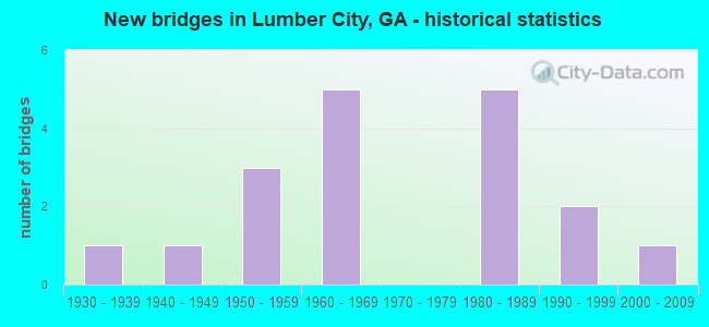
- New bridges - historical statistics
- 11930-1939
- 11940-1949
- 31950-1959
- 51960-1969
- 51980-1989
- 21990-1999
- 12000-2009

- Reconstructed bridges - Historical Statistics
- 11970-1979
- 01980-1989
- 11990-1999


- Bridge Condition - Deck
- 75.0%Good
- 25.0%Satisfactory

- Bridge Condition - Substructure
- 91.7%Good
- 8.3%Satisfactory

- Bridge Condition - Channel
- 44.4%Very good
- 38.9%Good
- 16.7%Satisfactory

- Bridge Condition - Culverts
- 83.3%Good
- 16.7%Satisfactory
Find on map >> Show street view
Structure Number: 1610005, Location: 4.6 MI NW OF HAZLEHURST (Lat: 31.906431, Lng: -82.660036), Route carried "on" structure: US 23, Year Built: 1984, Status: Open, Structure Length: 0.98m (3.22ft), Average Daily Traffic: 6,470 (year 2011), Truck Traffic: 1%, Average Future Daily Traffic: 9,705 (year 2031), Design Load: HS 20+Mod, Features Intersected: OCMULGEE RIVER OVERFLOW
Minimum Vertical Clearance: 30+ m (98+ ft), Kilometerpoint: 27.359, Lanes on structure: 4, Base Highway Network: Yes, Owner: State Highway Agency, Approaching Roadway Width: 18.9m (62.0ft), Skew: 10 degrees, Material/Design: Concrete, Design/Construction: Culvert, Number Of Spans In Main Unit: 3, Length of Maximum Span: 3.0m (9.8ft)
Condition: Channel: Very good, Culverts: Good, Operating Rating: 55.3 metric tons, Method Used To Determine Operating Rating: Field evaluation and documented engineering judgment, Inventory Rating: 32.6 metric tons, Method Used To Determine Inventory Rating: Field evaluation and documented engineering judgment, Structural Evaluation: Better than present minimum criteria, Waterway Adequacy: Equal to present desirable criteria, Approach Roadway Alignment: Equal to present desirable criteria, Designated Inspection Frequency: Every 24 months, Inspection Date: September 2020, Bridge Improvement Cost: $193,000, Roadway Improvement Cost: $19,000, Total Project Cost: $290,000
Find on map >> Show street view
Structure Number: 1610006, Location: 5.1 MI NW OF HAZLEHURST (Lat: 31.910569, Lng: -82.668539), Route carried "on" structure: US 23, Year Built: 1956, Status: Open, Structure Length: 6.04m (19.82ft), Average Daily Traffic: 6,470 (year 2011), Truck Traffic: 1%, Average Future Daily Traffic: 9,705 (year 2031), Design Load: HS 20, Features Intersected: OCMULGEE RIVER OVERFLOW
Minimum Vertical Clearance: 30+ m (98+ ft), Kilometerpoint: 28.968, Lanes on structure: 2, Base Highway Network: Yes, Owner: State Highway Agency, Approaching Roadway Width: 9.4m (30.8ft), Skew: 10 degrees, Material/Design: Concrete, Design/Construction: Tee Beam, Number Of Spans In Main Unit: 6, Length of Maximum Span: 10.1m (33.1ft), Curb or Sidewalk Widths: Left: 0.6m (2.0ft), Right: 0.6m (2.0ft), Curb-To-Curb Width: 8.4m (27.6ft), Out-to-Out Width: 10.4m (34.1ft)
Condition: Deck: Satisfactory, Superstructure: Good, Substructure: Good, Channel: Very good, Operating Rating: 37.1 metric tons, Method Used To Determine Operating Rating: Load Factor (LF), Inventory Rating: 22.6 metric tons, Method Used To Determine Inventory Rating: Load Factor (LF), Structural Evaluation: Somewhat better than minimum adequacy, Deck Geometry: High priority of corrective action, Waterway Adequacy: Equal to present desirable criteria, Approach Roadway Alignment: Better than present minimum criteria, Designated Inspection Frequency: Every 24 months, Inspection Date: September 2020, Bridge Improvement Cost: $774,000, Roadway Improvement Cost: $77,000, Total Project Cost: $1,160,000, Deck Structure Type: Concrete Cast-file-Place
Find on map >> Show street view
Structure Number: 1610007, Location: 5.3 MI NW OF HAZLEHURST (Lat: 31.912378, Lng: -82.669778), Route carried "on" structure: US 23, Year Built: 1956, Status: Open, Structure Length: 5.03m (16.50ft), Average Daily Traffic: 6,470 (year 2011), Truck Traffic: 1%, Average Future Daily Traffic: 9,705 (year 2031), Design Load: HS 20, Features Intersected: OCMULGEE RIVER OVERFLOW
Minimum Vertical Clearance: 30+ m (98+ ft), Kilometerpoint: 28.968, Lanes on structure: 2, Base Highway Network: Yes, Owner: State Highway Agency, Approaching Roadway Width: 9.4m (30.8ft), Skew: 10 degrees, Material/Design: Concrete, Design/Construction: Tee Beam, Number Of Spans In Main Unit: 5, Length of Maximum Span: 10.1m (33.1ft), Curb or Sidewalk Widths: Left: 0.6m (2.0ft), Right: 0.6m (2.0ft), Curb-To-Curb Width: 8.4m (27.6ft), Out-to-Out Width: 10.4m (34.1ft)
Condition: Deck: Satisfactory, Superstructure: Good, Substructure: Good, Channel: Very good, Operating Rating: 37.1 metric tons, Method Used To Determine Operating Rating: Load Factor (LF), Inventory Rating: 22.6 metric tons, Method Used To Determine Inventory Rating: Load Factor (LF), Structural Evaluation: Somewhat better than minimum adequacy, Deck Geometry: High priority of corrective action, Waterway Adequacy: Equal to present desirable criteria, Approach Roadway Alignment: Better than present minimum criteria, Designated Inspection Frequency: Every 24 months, Inspection Date: September 2020, Bridge Improvement Cost: $645,000, Roadway Improvement Cost: $64,000, Total Project Cost: $967,000, Deck Structure Type: Concrete Cast-file-Place
Find on map >> Show street view
Structure Number: 1610008, Location: 5.6 MI NW OF HAZLEHURST (Lat: 31.915800, Lng: -82.671858), Route carried "on" structure: US 23, Year Built: 1967, Status: Open, Structure Length: 15.85m (52.00ft), Average Daily Traffic: 6,470 (year 2011), Truck Traffic: 1%, Average Future Daily Traffic: 9,705 (year 2031), Design Load: HS 20+Mod, Features Intersected: OCMULGEE RIVER OVERFLOW
Minimum Vertical Clearance: 30+ m (98+ ft), Kilometerpoint: 28.968, Lanes on structure: 2, Base Highway Network: Yes, Owner: State Highway Agency, Approaching Roadway Width: 9.4m (30.8ft), Skew: 10 degrees, Material/Design: Steel continuous, Design/Construction: Stringer/Multi-beam, Number Of Spans In Main Unit: 26, Length of Maximum Span: 6.1m (20.0ft), Curb or Sidewalk Widths: Left: 0.6m (2.0ft), Right: 0.6m (2.0ft), Curb-To-Curb Width: 8.5m (27.9ft), Out-to-Out Width: 10.5m (34.4ft)
Condition: Deck: Satisfactory, Superstructure: Good, Substructure: Satisfactory, Channel: Good, Operating Rating: 39.0 metric tons, Method Used To Determine Operating Rating: Load Factor (LF), Inventory Rating: 23.5 metric tons, Method Used To Determine Inventory Rating: Load Factor (LF), Structural Evaluation: Somewhat better than minimum adequacy, Deck Geometry: High priority of corrective action, Waterway Adequacy: Equal to present desirable criteria, Approach Roadway Alignment: Better than present minimum criteria, Designated Inspection Frequency: Every 24 months, Inspection Date: September 2020, Bridge Improvement Cost: $2,032,000, Roadway Improvement Cost: $203,000, Total Project Cost: $3,048,000, Deck Structure Type: Concrete Cast-file-Place
Find on map >> Show street view
Structure Number: 1610033, Location: 4.4 MI NW OF HAZLEHURST (Lat: 31.905697, Lng: -82.656553), Route carried "on" structure: US 23, Year Built: 1935, Year Reconstructed: 1984, Status: Open, Structure Length: 1.31m (4.30ft), Average Daily Traffic: 6,470 (year 2011), Truck Traffic: 1%, Average Future Daily Traffic: 9,705 (year 2031), Design Load: H 15, Features Intersected: OCMULGEE RIVER OVERFLOW
Minimum Vertical Clearance: 30+ m (98+ ft), Kilometerpoint: 27.359, Lanes on structure: 4, Base Highway Network: Yes, Owner: State Highway Agency, Approaching Roadway Width: 18.9m (62.0ft), Skew: 10 degrees, Material/Design: Concrete, Design/Construction: Culvert, Number Of Spans In Main Unit: 4, Length of Maximum Span: 3.0m (9.8ft)
Condition: Channel: Good, Culverts: Good, Operating Rating: 41.7 metric tons, Method Used To Determine Operating Rating: Field evaluation and documented engineering judgment, Inventory Rating: 24.4 metric tons, Method Used To Determine Inventory Rating: Field evaluation and documented engineering judgment, Structural Evaluation: Equal to present minimum criteria, Waterway Adequacy: Equal to present minimum criteria, Approach Roadway Alignment: Better than present minimum criteria, Designated Inspection Frequency: Every 24 months, Inspection Date: September 2020, Bridge Improvement Cost: $260,000, Roadway Improvement Cost: $26,000, Total Project Cost: $389,000
Find on map >> Show street view
Structure Number: 1610034, Location: 5.1 MI NW OF HAZLEHURST (Lat: 31.910439, Lng: -82.668728), Route carried "on" structure: US 23, Year Built: 1984, Status: Open, Structure Length: 0.64m (2.10ft), Average Daily Traffic: 6,470 (year 2011), Truck Traffic: 1%, Average Future Daily Traffic: 9,705 (year 2031), Design Load: HS 20+Mod, Features Intersected: OCMULGEE RIVER OVERFLOW
Minimum Vertical Clearance: 30+ m (98+ ft), Kilometerpoint: 28.968, Lanes on structure: 2, Base Highway Network: Yes, Owner: State Highway Agency, Approaching Roadway Width: 9.4m (30.8ft), Skew: 10 degrees, Material/Design: Concrete, Design/Construction: Culvert, Number Of Spans In Main Unit: 2, Length of Maximum Span: 3.0m (9.8ft)
Condition: Channel: Very good, Culverts: Good, Operating Rating: 55.3 metric tons, Method Used To Determine Operating Rating: Field evaluation and documented engineering judgment, Inventory Rating: 32.6 metric tons, Method Used To Determine Inventory Rating: Field evaluation and documented engineering judgment, Structural Evaluation: Better than present minimum criteria, Waterway Adequacy: Equal to present desirable criteria, Approach Roadway Alignment: Equal to present desirable criteria, Designated Inspection Frequency: Every 24 months, Inspection Date: September 2020, Bridge Improvement Cost: $82,000, Roadway Improvement Cost: $8,000, Total Project Cost: $123,000
Find on map >> Show street view
Structure Number: 1610035, Location: 5.3 MI NW OF HAZLEHURST (Lat: 31.912278, Lng: -82.669978), Route carried "on" structure: US 23, Year Built: 1985, Status: Open, Structure Length: 5.00m (16.40ft), Average Daily Traffic: 6,470 (year 2011), Truck Traffic: 1%, Average Future Daily Traffic: 9,705 (year 2031), Design Load: HS 20+Mod, Features Intersected: OCMULGEE RIVER OVERFLOW
Minimum Vertical Clearance: 30+ m (98+ ft), Kilometerpoint: 28.968, Lanes on structure: 2, Base Highway Network: Yes, Owner: State Highway Agency, Approaching Roadway Width: 9.4m (30.8ft), Skew: 10 degrees, Material/Design: Concrete continuous, Design/Construction: Tee Beam, Number Of Spans In Main Unit: 4, Length of Maximum Span: 12.5m (41.0ft), Curb-To-Curb Width: 11.6m (38.1ft), Out-to-Out Width: 12.5m (41.0ft)
Condition: Deck: Good, Superstructure: Good, Substructure: Good, Channel: Very good, Operating Rating: 34.4 metric tons, Method Used To Determine Operating Rating: Load Factor (LF), Inventory Rating: 20.8 metric tons, Method Used To Determine Inventory Rating: Load Factor (LF), Structural Evaluation: Somewhat better than minimum adequacy, Deck Geometry: Somewhat better than minimum adequacy, Waterway Adequacy: Equal to present desirable criteria, Approach Roadway Alignment: Better than present minimum criteria, Designated Inspection Frequency: Every 24 months, Inspection Date: September 2020, Bridge Improvement Cost: $641,000, Roadway Improvement Cost: $64,000, Total Project Cost: $961,000, Deck Structure Type: Concrete Cast-file-Place
Find on map >> Show street view
Structure Number: 1610036, Location: 5.6 MI NW OF HAZLEHURST (Lat: 31.915708, Lng: -82.672058), Route carried "on" structure: US 23, Year Built: 1985, Status: Open, Structure Length: 15.85m (52.00ft), Average Daily Traffic: 6,470 (year 2011), Truck Traffic: 1%, Average Future Daily Traffic: 9,705 (year 2031), Design Load: HS 20+Mod, Features Intersected: OCMULGEE RIVER OVERFLOW
Minimum Vertical Clearance: 30+ m (98+ ft), Kilometerpoint: 28.968, Lanes on structure: 2, Base Highway Network: Yes, Owner: State Highway Agency, Approaching Roadway Width: 9.4m (30.8ft), Skew: 10 degrees, Material/Design: Concrete continuous, Design/Construction: Tee Beam, Number Of Spans In Main Unit: 13, Length of Maximum Span: 12.2m (40.0ft), Curb-To-Curb Width: 11.6m (38.1ft), Out-to-Out Width: 12.5m (41.0ft)
Condition: Deck: Good, Superstructure: Good, Substructure: Good, Channel: Very good, Operating Rating: 28.1 metric tons, Method Used To Determine Operating Rating: Load Factor (LF), Inventory Rating: 16.3 metric tons, Method Used To Determine Inventory Rating: Load Factor (LF), Structural Evaluation: Meets minimum limits, Deck Geometry: Somewhat better than minimum adequacy, Waterway Adequacy: Equal to present desirable criteria, Approach Roadway Alignment: Better than present minimum criteria, Designated Inspection Frequency: Every 24 months, Inspection Date: September 2020, Bridge Improvement Cost: $2,032,000, Roadway Improvement Cost: $203,000, Total Project Cost: $3,048,000, Deck Structure Type: Concrete Cast-file-Place
Find on map >> Show street view
Structure Number: 1610037, Location: 5.8 MI NW OF HAZLEHURST (Lat: 31.919739, Lng: -82.674319), Route carried "on" structure: US 23, Year Built: 1985, Status: Open, Structure Length: 37.67m (123.59ft), Average Daily Traffic: 5,540 (year 2012), Truck Traffic: 1%, Average Future Daily Traffic: 8,310 (year 2032), Design Load: HS 20+Mod, Features Intersected: OCMULGEE RIVER
Minimum Vertical Clearance: 30+ m (98+ ft), Kilometerpoint: 28.968, Lanes on structure: 2, Base Highway Network: Yes, Owner: State Highway Agency, Approaching Roadway Width: 8.5m (27.9ft), Skew: 10 degrees, Material/Design: Prestressed concrete, Design/Construction: Stringer/Multi-beam, Number Of Spans In Main Unit: 4, Number Of Approach Spans: 20, Length of Maximum Span: 31.7m (104.0ft), Curb-To-Curb Width: 11.6m (38.1ft), Out-to-Out Width: 12.5m (41.0ft)
Condition: Deck: Good, Superstructure: Good, Substructure: Good, Channel: Good, Operating Rating: 80.7 metric tons, Method Used To Determine Operating Rating: Load Factor (LF), Inventory Rating: 19.0 metric tons, Method Used To Determine Inventory Rating: Load Factor (LF), Structural Evaluation: Meets minimum limits, Deck Geometry: Somewhat better than minimum adequacy, Waterway Adequacy: Equal to present desirable criteria, Approach Roadway Alignment: Better than present minimum criteria, Designated Inspection Frequency: Every 24 months, Underwater Inspection Frequency: Every 60 months, Inspection Date: September 2020, Underwater Inspection Date: August 2020, Bridge Improvement Cost: $4,829,000, Roadway Improvement Cost: $483,000, Total Project Cost: $7,244,000, Deck Structure Type: Concrete Cast-file-Place
Find on map >> Show street view
Structure Number: 1615001, Location: 5.5 MI W OF HAZLEHURST (Lat: 31.880819, Lng: -82.687919), Route carried "on" structure: County highway 6, Year Built: 1960, Status: Open, Structure Length: 0.79m (2.59ft), Average Daily Traffic: 2,630 (year 2011), Truck Traffic: 1%, Average Future Daily Traffic: 3,945 (year 2031), Design Load: H 15, Features Intersected: OCMULGEE RIVER TRIB, Facility Carried by Structure: BURKETTS FERRY RD
Minimum Vertical Clearance: 30+ m (98+ ft), Kilometerpoint: 9.656, Lanes on structure: 2, Base Highway Network: Yes, Owner: County Highway Agency, Approaching Roadway Width: 6.1m (20.0ft), Material/Design: Concrete, Design/Construction: Culvert, Number Of Spans In Main Unit: 3, Length of Maximum Span: 2.4m (7.9ft)
Condition: Channel: Good, Culverts: Satisfactory, Operating Rating: 41.7 metric tons, Method Used To Determine Operating Rating: Field evaluation and documented engineering judgment, Inventory Rating: 24.4 metric tons, Method Used To Determine Inventory Rating: Field evaluation and documented engineering judgment, Structural Evaluation: Equal to present minimum criteria, Waterway Adequacy: Equal to present desirable criteria, Approach Roadway Alignment: Equal to present desirable criteria, Designated Inspection Frequency: Every 24 months, Inspection Date: September 2020, Bridge Improvement Cost: $102,000, Roadway Improvement Cost: $10,000, Total Project Cost: $152,000
Find on map >> Show street view
Structure Number: 161502, Location: 5.8 MI NW OF HAZLEHURST (Lat: 31.919797, Lng: -82.674078), Route carried "on" structure: US 23, Year Built: 2005, Status: Open, Structure Length: 37.31m (122.41ft), Average Daily Traffic: 5,540 (year 2012), Truck Traffic: 1%, Average Future Daily Traffic: 8,310 (year 2032), Design Load: HS 20+Mod, Features Intersected: OCMULGEE RIVER
Minimum Vertical Clearance: 30+ m (98+ ft), Kilometerpoint: 28.968, Lanes on structure: 2, Base Highway Network: Yes, Owner: State Highway Agency, Approaching Roadway Width: 10.1m (33.1ft), Skew: 10 degrees, Material/Design: Prestressed concrete, Design/Construction: Stringer/Multi-beam, Number Of Spans In Main Unit: 16, Length of Maximum Span: 43.9m (144.0ft), Curb-To-Curb Width: 11.6m (38.1ft), Out-to-Out Width: 12.5m (41.0ft)
Condition: Deck: Good, Superstructure: Good, Substructure: Good, Channel: Very good, Operating Rating: 57.1 metric tons, Method Used To Determine Operating Rating: Load Factor (LF), Inventory Rating: 32.6 metric tons, Method Used To Determine Inventory Rating: Load Factor (LF), Structural Evaluation: Better than present minimum criteria, Deck Geometry: Somewhat better than minimum adequacy, Waterway Adequacy: Equal to present desirable criteria, Approach Roadway Alignment: Equal to present desirable criteria, Designated Inspection Frequency: Every 24 months, Underwater Inspection Frequency: Every 60 months, Inspection Date: September 2020, Underwater Inspection Date: August 2020, Bridge Improvement Cost: $4,782,000, Roadway Improvement Cost: $478,000, Total Project Cost: $7,174,000, Deck Structure Type: Concrete Cast-file-Place
Find on map >> Show street view
Structure Number: 2710003, Location: 3 MI NW OF LUMBER CITY (Lat: 31.960669, Lng: -82.722972), Route carried "on" structure: US 23, Year Built: 1951, Year Reconstructed: 1999, Status: Open, Structure Length: 7.32m (24.02ft), Average Daily Traffic: 2,940 (year 2011), Truck Traffic: 1%, Average Future Daily Traffic: 4,410 (year 2031), Design Load: HS 20, Features Intersected: SUGAR CREEK
Minimum Vertical Clearance: 30+ m (98+ ft), Kilometerpoint: 28.968, Lanes on structure: 2, Base Highway Network: Yes, Owner: State Highway Agency, Approaching Roadway Width: 9.1m (29.9ft), Skew: 10 degrees, Material/Design: Steel continuous, Design/Construction: Stringer/Multi-beam, Number Of Spans In Main Unit: 6, Length of Maximum Span: 12.2m (40.0ft), Curb-To-Curb Width: 12.3m (40.4ft), Out-to-Out Width: 13.2m (43.3ft)
Condition: Deck: Good, Superstructure: Good, Substructure: Good, Channel: Satisfactory, Operating Rating: 68.9 metric tons, Method Used To Determine Operating Rating: Load Factor (LF), Inventory Rating: 41.7 metric tons, Method Used To Determine Inventory Rating: Load Factor (LF), Structural Evaluation: Better than present minimum criteria, Deck Geometry: Better than present minimum criteria, Waterway Adequacy: Equal to present minimum criteria, Approach Roadway Alignment: Equal to present desirable criteria, Designated Inspection Frequency: Every 24 months, Underwater Inspection Frequency: Every 60 months, Inspection Date: Febuary 2021, Underwater Inspection Date: Febuary 2020, Bridge Improvement Cost: $938,000, Roadway Improvement Cost: $94,000, Total Project Cost: $1,407,000, Deck Structure Type: Concrete Cast-file-Place
Find on map >> Show street view
Structure Number: 2710031, Location: 2 MI SW OF LUMBER CITY (Lat: 31.908469, Lng: -82.703069), Route carried "on" structure: State highway 117, Year Built: 1949, Status: Open, Structure Length: 0.88m (2.89ft), Average Daily Traffic: 690 (year 2011), Truck Traffic: 1%, Average Future Daily Traffic: 1,035 (year 2031), Design Load: H 15, Features Intersected: CEMETERY BRANCH
Minimum Vertical Clearance: 30+ m (98+ ft), Kilometerpoint: 3.557, Lanes on structure: 2, Base Highway Network: Yes, Owner: State Highway Agency, Approaching Roadway Width: 7.6m (24.9ft), Material/Design: Concrete, Design/Construction: Culvert, Number Of Spans In Main Unit: 3, Length of Maximum Span: 2.7m (8.9ft)
Condition: Channel: Good, Culverts: Good, Operating Rating: 44.4 metric tons, Method Used To Determine Operating Rating: Load Factor (LF), Inventory Rating: 26.3 metric tons, Method Used To Determine Inventory Rating: Load Factor (LF), Structural Evaluation: Equal to present minimum criteria, Waterway Adequacy: Equal to present minimum criteria, Approach Roadway Alignment: Equal to present desirable criteria, Designated Inspection Frequency: Every 24 months, Inspection Date: January 2021, Bridge Improvement Cost: $113,000, Roadway Improvement Cost: $11,000, Total Project Cost: $170,000
Find on map >> Show street view
Structure Number: 2710057, Location: .6 MI NE OF LUMBER CITY (Lat: 31.935478, Lng: -82.670389), Route carried "on" structure: State highway 19, Year Built: 1990, Status: Open, Structure Length: 20.42m (66.99ft), Average Daily Traffic: 2,330 (year 2011), Truck Traffic: 1%, Average Future Daily Traffic: 3,495 (year 2031), Design Load: HS 20+Mod, Features Intersected: LITTLE OCMULGEE RIVER
Minimum Vertical Clearance: 30+ m (98+ ft), Kilometerpoint: 1.609, Lanes on structure: 2, Base Highway Network: Yes, Owner: State Highway Agency, Approaching Roadway Width: 8.5m (27.9ft), Material/Design: Prestressed concrete, Design/Construction: Stringer/Multi-beam, Number Of Spans In Main Unit: 13, Length of Maximum Span: 21.3m (69.9ft), Curb-To-Curb Width: 12.2m (40.0ft), Out-to-Out Width: 13.2m (43.3ft)
Condition: Deck: Good, Superstructure: Good, Substructure: Good, Channel: Satisfactory, Operating Rating: 32.6 metric tons, Method Used To Determine Operating Rating: Load Factor (LF), Inventory Rating: 19.0 metric tons, Method Used To Determine Inventory Rating: Load Factor (LF), Structural Evaluation: Somewhat better than minimum adequacy, Deck Geometry: Equal to present minimum criteria, Waterway Adequacy: Equal to present minimum criteria, Approach Roadway Alignment: Equal to present desirable criteria, Designated Inspection Frequency: Every 24 months, Underwater Inspection Frequency: Every 60 months, Inspection Date: January 2021, Underwater Inspection Date: Febuary 2020, Bridge Improvement Cost: $2,618,000, Roadway Improvement Cost: $262,000, Total Project Cost: $3,927,000, Deck Structure Type: Concrete Cast-file-Place
Find on map >> Show street view
Structure Number: 2715012, Location: 2.9 MI N OF LUMBER CITY (Lat: 31.966119, Lng: -82.705028), Route carried "on" structure: County highway 188, Year Built: 1968, Status: Open, Structure Length: 8.53m (27.99ft), Average Daily Traffic: 260 (year 2011), Truck Traffic: 1%, Average Future Daily Traffic: 390 (year 2031), Design Load: HS 15, Features Intersected: SUGAR CREEK, Facility Carried by Structure: OLD SAND PIT ROAD
Minimum Vertical Clearance: 30+ m (98+ ft), Kilometerpoint: 3.219, Lanes on structure: 2, Base Highway Network: Yes, Owner: County Highway Agency, Approaching Roadway Width: 6.1m (20.0ft), Material/Design: Concrete, Design/Construction: Tee Beam, Number Of Spans In Main Unit: 7, Length of Maximum Span: 12.2m (40.0ft), Curb or Sidewalk Widths: Left: 0.2m (0.7ft), Right: 0.2m (0.7ft), Curb-To-Curb Width: 8.2m (26.9ft), Out-to-Out Width: 9.3m (30.5ft)
Condition: Deck: Good, Superstructure: Good, Substructure: Good, Channel: Good, Operating Rating: 33.5 metric tons, Method Used To Determine Operating Rating: Load Factor (LF), Inventory Rating: 19.9 metric tons, Method Used To Determine Inventory Rating: Load Factor (LF), Structural Evaluation: Somewhat better than minimum adequacy, Deck Geometry: Somewhat better than minimum adequacy, Waterway Adequacy: Better than present minimum criteria, Approach Roadway Alignment: Better than present minimum criteria, Designated Inspection Frequency: Every 24 months, Inspection Date: Febuary 2021, Bridge Improvement Cost: $1,094,000, Roadway Improvement Cost: $109,000, Total Project Cost: $1,641,000, Deck Structure Type: Concrete Cast-file-Place
Find on map >> Show street view
Structure Number: 2715013, Location: 3.3 MI N OF LUMBER CITY (Lat: 31.972828, Lng: -82.704678), Route carried "on" structure: County highway 188, Year Built: 1968, Status: Open, Structure Length: 11.09m (36.38ft), Average Daily Traffic: 260 (year 2011), Truck Traffic: 1%, Average Future Daily Traffic: 390 (year 2031), Design Load: HS 15, Features Intersected: LITTLE OCMULGEE RIVER, Facility Carried by Structure: OLD SAND PIT ROAD
Minimum Vertical Clearance: 30+ m (98+ ft), Kilometerpoint: 4.828, Lanes on structure: 2, Base Highway Network: Yes, Owner: County Highway Agency, Approaching Roadway Width: 6.1m (20.0ft), Material/Design: Concrete, Design/Construction: Tee Beam, Number Of Spans In Main Unit: 10, Length of Maximum Span: 12.2m (40.0ft), Curb or Sidewalk Widths: Left: 0.2m (0.7ft), Right: 0.2m (0.7ft), Curb-To-Curb Width: 8.2m (26.9ft), Out-to-Out Width: 9.3m (30.5ft)
Condition: Deck: Good, Superstructure: Good, Substructure: Good, Channel: Satisfactory, Operating Rating: 32.6 metric tons, Method Used To Determine Operating Rating: Load Factor (LF), Inventory Rating: 19.0 metric tons, Method Used To Determine Inventory Rating: Load Factor (LF), Structural Evaluation: Somewhat better than minimum adequacy, Deck Geometry: Somewhat better than minimum adequacy, Waterway Adequacy: Better than present minimum criteria, Approach Roadway Alignment: Equal to present desirable criteria, Designated Inspection Frequency: Every 24 months, Underwater Inspection Frequency: Every 60 months, Inspection Date: Febuary 2021, Underwater Inspection Date: Febuary 2020, Bridge Improvement Cost: $1,422,000, Roadway Improvement Cost: $142,000, Total Project Cost: $2,133,000, Deck Structure Type: Concrete Cast-file-Place
Find on map >> Show street view
Structure Number: 2715025, Location: 3 MI NW OF LUMBER CITY (Lat: 31.960522, Lng: -82.723131), Route carried "on" structure: US 23, Year Built: 1999, Status: Open, Structure Length: 8.53m (27.99ft), Average Daily Traffic: 2,940 (year 2011), Truck Traffic: 1%, Average Future Daily Traffic: 4,410 (year 2031), Design Load: HS 20+Mod, Features Intersected: SUGAR CREEK
Minimum Vertical Clearance: 30+ m (98+ ft), Kilometerpoint: 28.968, Lanes on structure: 2, Base Highway Network: Yes, Owner: State Highway Agency, Approaching Roadway Width: 9.1m (29.9ft), Skew: 10 degrees, Material/Design: Prestressed concrete, Design/Construction: Stringer/Multi-beam, Number Of Spans In Main Unit: 6, Length of Maximum Span: 24.4m (80.1ft), Curb-To-Curb Width: 11.6m (38.1ft), Out-to-Out Width: 12.6m (41.3ft)
Condition: Deck: Good, Superstructure: Good, Substructure: Good, Channel: Very good, Operating Rating: 57.1 metric tons, Method Used To Determine Operating Rating: Load Factor (LF), Inventory Rating: 34.4 metric tons, Method Used To Determine Inventory Rating: Load Factor (LF), Structural Evaluation: Better than present minimum criteria, Deck Geometry: Better than present minimum criteria, Waterway Adequacy: Equal to present desirable criteria, Approach Roadway Alignment: Equal to present desirable criteria, Designated Inspection Frequency: Every 24 months, Inspection Date: Febuary 2021, Bridge Improvement Cost: $1,094,000, Roadway Improvement Cost: $109,000, Total Project Cost: $1,641,000, Deck Structure Type: Concrete Cast-file-Place
Find on map >> Show street view
Structure Number: 3090025, Location: 16 MI S OF GLENWOOD (Lat: 31.953278, Lng: -82.628797), Route carried "on" structure: County highway 2762, Year Built: 1964, Status: Open, Structure Length: 0.88m (2.89ft), Average Daily Traffic: 470 (year 2011), Truck Traffic: 1%, Average Future Daily Traffic: 705 (year 2031), Design Load: H 15, Features Intersected: TILLMAN MILL CREEK, Facility Carried by Structure: BELLS FERRY ROAD
Minimum Vertical Clearance: 30+ m (98+ ft), Kilometerpoint: 1.609, Lanes on structure: 2, Base Highway Network: Yes, Owner: County Highway Agency, Approaching Roadway Width: 6.7m (22.0ft), Material/Design: Concrete, Design/Construction: Culvert, Number Of Spans In Main Unit: 3, Length of Maximum Span: 2.7m (8.9ft)
Condition: Channel: Good, Culverts: Good, Operating Rating: 40.8 metric tons, Method Used To Determine Operating Rating: Field evaluation and documented engineering judgment, Inventory Rating: 24.4 metric tons, Method Used To Determine Inventory Rating: Field evaluation and documented engineering judgment, Structural Evaluation: Equal to present minimum criteria, Waterway Adequacy: Equal to present minimum criteria, Approach Roadway Alignment: Equal to present desirable criteria, Designated Inspection Frequency: Every 24 months, Inspection Date: July 2020, Bridge Improvement Cost: $113,000, Roadway Improvement Cost: $11,000, Total Project Cost: $170,000