Bridge Statistics for Lumberport, West Virginia (WV)
Condition, Traffic, Stress, Structural Evaluation, Project Costs
- National Bridge Inventory (NBI) Statistics
- 16Number of bridges
- 151ft / 45.7mTotal length
- $8,443,000Total costs
- 20,075Total average daily traffic
- 1,200Total average daily truck traffic
- National Bridge Inventory (NBI) Registered Bridges for Lumberport
- No street view available for this location
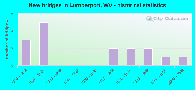
- New bridges - historical statistics
- 31910-1919
- 51920-1929
- 21960-1969
- 21970-1979
- 21980-1989
- 11990-1999
- 12000-2009


- Bridge Condition - Deck
- 25.0%Good
- 25.0%Satisfactory
- 12.5%Fair
- 37.5%Poor

- Bridge Condition - Superstructure
- 25.0%Good
- 8.3%Satisfactory
- 8.3%Fair
- 50.0%Poor
- 8.3%Serious

- Bridge Condition - Substructure
- 10.0%Very good
- 30.0%Good
- 30.0%Satisfactory
- 30.0%Fair

- Bridge Condition - Channel
- 15.4%Very good
- 30.8%Good
- 30.8%Satisfactory
- 15.4%Fair
- 7.7%Poor
Find on map >> Show street view
Structure Number: 17A005, Location: 0.02 MI EAST CO RT 3/17 (Lat: 39.396550, Lng: -80.336519), Route carried "on" structure: County highway 300, Year Built: 1915, Status: Open, Structure Length: 0.91m (2.99ft), Average Daily Traffic: 1,300 (year 2019), Truck Traffic: 8%, Average Future Daily Traffic: 1,780 (year 2041), Features Intersected: ROBINSON RUN, Facility Carried by Structure: HARRISON CO RT 3
Minimum Vertical Clearance: 30+ m (98+ ft), Kilometerpoint: 11.732, Lanes on structure: 2, Owner: State Highway Agency, Approaching Roadway Width: 7.3m (24.0ft), Skew: 3 degrees, Material/Design: Concrete, Design/Construction: Arch - Deck, Number Of Spans In Main Unit: 1, Length of Maximum Span: 9.1m (29.9ft), Curb-To-Curb Width: 6.3m (20.7ft), Out-to-Out Width: 8.7m (28.5ft)
Condition: Superstructure: Poor, Substructure: Satisfactory, Channel: Satisfactory, Operating Rating: 47.2 metric tons, Method Used To Determine Operating Rating: Field evaluation and documented engineering judgment, Inventory Rating: 21.8 metric tons, Method Used To Determine Inventory Rating: Field evaluation and documented engineering judgment, Structural Evaluation: Meets minimum limits, Deck Geometry: High priority of replacement, Waterway Adequacy: Equal to present minimum criteria, Approach Roadway Alignment: Equal to present minimum criteria, Length Of Structure Improvement: 0.98m (3.22ft), Designated Inspection Frequency: Every 24 months, Inspection Date: June 2021, Bridge Improvement Cost: $274,000, Roadway Improvement Cost: $121,000, Total Project Cost: $487,000 ( Estimate for 2021)
Find on map >> Show street view
Structure Number: 17A033, Location: 0.02 MI NORTH CR 6/5 (Lat: 39.384461, Lng: -80.369939), Route carried "on" structure: County highway 600, Year Built: 1920, Status: Open, Structure Length: 0.99m (3.25ft), Average Daily Traffic: 400 (year 2019), Truck Traffic: 8%, Average Future Daily Traffic: 550 (year 2041), Features Intersected: JONES CREEK, Facility Carried by Structure: HARRISON CO RT 6
Minimum Vertical Clearance: 30+ m (98+ ft), Kilometerpoint: 2.639, Lanes on structure: 2, Owner: State Highway Agency, Approaching Roadway Width: 6.1m (20.0ft), Skew: 1 degrees, Material/Design: Concrete, Design/Construction: Arch - Deck, Number Of Spans In Main Unit: 1, Length of Maximum Span: 9.9m (32.5ft), Curb-To-Curb Width: 4.9m (16.1ft), Out-to-Out Width: 5.7m (18.7ft)
Condition: Superstructure: Fair, Substructure: Satisfactory, Channel: Satisfactory, Operating Rating: 47.2 metric tons, Method Used To Determine Operating Rating: Field evaluation and documented engineering judgment, Inventory Rating: 21.8 metric tons, Method Used To Determine Inventory Rating: Field evaluation and documented engineering judgment, Structural Evaluation: Somewhat better than minimum adequacy, Deck Geometry: High priority of replacement, Waterway Adequacy: Better than present minimum criteria, Approach Roadway Alignment: Equal to present minimum criteria, Length Of Structure Improvement: 1.07m (3.51ft), Designated Inspection Frequency: Every 24 months, Inspection Date: March 2021, Bridge Improvement Cost: $182,000, Roadway Improvement Cost: $111,000, Total Project Cost: $347,000 ( Estimate for 2021)
Find on map >> Show street view
Structure Number: 17A034, Location: 0.01 MI NORTH CR 20/7 (Lat: 39.384669, Lng: -80.380439), Route carried "on" structure: County highway 600, Year Built: 1920, Status: Open, Structure Length: 1.23m (4.04ft), Average Daily Traffic: 400 (year 2019), Truck Traffic: 8%, Average Future Daily Traffic: 550 (year 2041), Features Intersected: JONES CREEK, Facility Carried by Structure: HARRISON CO RT 6
Minimum Vertical Clearance: 30+ m (98+ ft), Kilometerpoint: 3.718, Lanes on structure: 2, Owner: State Highway Agency, Approaching Roadway Width: 6.1m (20.0ft), Skew: 2 degrees, Material/Design: Concrete, Design/Construction: Arch - Deck, Number Of Spans In Main Unit: 1, Length of Maximum Span: 12.3m (40.4ft), Curb-To-Curb Width: 5.0m (16.4ft), Out-to-Out Width: 5.7m (18.7ft)
Condition: Superstructure: Poor, Substructure: Fair, Channel: Poor, Operating Rating: 47.2 metric tons, Method Used To Determine Operating Rating: Field evaluation and documented engineering judgment, Inventory Rating: 21.8 metric tons, Method Used To Determine Inventory Rating: Field evaluation and documented engineering judgment, Structural Evaluation: Meets minimum limits, Deck Geometry: High priority of replacement, Waterway Adequacy: Somewhat better than minimum adequacy, Approach Roadway Alignment: Better than present minimum criteria, Length Of Structure Improvement: 1.28m (4.20ft), Designated Inspection Frequency: Every 24 months, Inspection Date: March 2021, Bridge Improvement Cost: $272,000, Roadway Improvement Cost: $141,000, Total Project Cost: $485,000 ( Estimate for 2021)
Find on map >> Show street view
Structure Number: 17A047, Location: 0.17 MI EAST CO RT 8/3 (Lat: 39.425219, Lng: -80.367439), Route carried "on" structure: County highway 800, Year Built: 1918, Status: Posted for load, Structure Length: 0.91m (2.99ft), Average Daily Traffic: 250 (year 2019), Truck Traffic: 8%, Average Future Daily Traffic: 340 (year 2041), Features Intersected: CUNNINGHAM RUN, Facility Carried by Structure: HARRISON CO RT 8
Minimum Vertical Clearance: 30+ m (98+ ft), Kilometerpoint: 6.904, Lanes on structure: 2, Owner: State Highway Agency, Approaching Roadway Width: 4.9m (16.1ft), Skew: 4 degrees, Material/Design: Concrete, Design/Construction: Arch - Deck, Number Of Spans In Main Unit: 1, Length of Maximum Span: 9.1m (29.9ft), Curb-To-Curb Width: 5.0m (16.4ft), Out-to-Out Width: 5.5m (18.0ft)
Condition: Superstructure: Poor, Channel: Fair, Operating Rating: 29.9 metric tons, Method Used To Determine Operating Rating: Field evaluation and documented engineering judgment, Inventory Rating: 13.6 metric tons, Method Used To Determine Inventory Rating: Field evaluation and documented engineering judgment, Structural Evaluation: Meets minimum limits, Deck Geometry: High priority of replacement, Waterway Adequacy: Equal to present minimum criteria, Approach Roadway Alignment: Equal to present minimum criteria, Bridge Posting: Required (Relationship of Operating Rating to Maximum Legal Load: 20.0 - 29.9% below), Length Of Structure Improvement: 1.55m (5.09ft), Designated Inspection Frequency: Every 24 months, Inspection Date: April 2021, Bridge Improvement Cost: $254,000, Roadway Improvement Cost: $151,000, Total Project Cost: $488,000 ( Estimate for 2021)
Find on map >> Show street view
Structure Number: 17A048, Location: 0.75 MI EAST CO RT 8/3 (Lat: 39.420339, Lng: -80.362661), Route carried "on" structure: County highway 800, Year Built: 1918, Status: Posted for load, Structure Length: 0.73m (2.40ft), Average Daily Traffic: 250 (year 2019), Truck Traffic: 8%, Average Future Daily Traffic: 340 (year 2041), Features Intersected: CUNNINGHAM RUN, Facility Carried by Structure: HARRISON CO RT 8
Minimum Vertical Clearance: 30+ m (98+ ft), Kilometerpoint: 7.838, Lanes on structure: 2, Owner: State Highway Agency, Approaching Roadway Width: 4.3m (14.1ft), Skew: 4 degrees, Material/Design: Concrete, Design/Construction: Slab, Number Of Spans In Main Unit: 1, Length of Maximum Span: 6.3m (20.7ft), Curb-To-Curb Width: 4.9m (16.1ft), Out-to-Out Width: 5.5m (18.0ft)
Condition: Deck: Poor, Superstructure: Poor, Substructure: Fair, Channel: Satisfactory, Operating Rating: 29.9 metric tons, Method Used To Determine Operating Rating: Field evaluation and documented engineering judgment, Inventory Rating: 13.6 metric tons, Method Used To Determine Inventory Rating: Field evaluation and documented engineering judgment, Structural Evaluation: Meets minimum limits, Deck Geometry: High priority of replacement, Waterway Adequacy: Equal to present minimum criteria, Approach Roadway Alignment: Better than present minimum criteria, Bridge Posting: Required (Relationship of Operating Rating to Maximum Legal Load: 20.0 - 29.9% below), Length Of Structure Improvement: 1.31m (4.30ft), Designated Inspection Frequency: Every 24 months, Inspection Date: April 2021, Bridge Improvement Cost: $192,000, Roadway Improvement Cost: $141,000, Total Project Cost: $453,000 ( Estimate for 2021), Deck Structure Type: Concrete Cast-file-Place, Wearing Surface/Protective System: Wearing Surface: Bituminous
Find on map >> Show street view
Structure Number: 17A065, Location: 0.05 MI SOUTH WV RT 20 (Lat: 39.373569, Lng: -80.347731), Route carried "on" structure: County highway 1800, Year Built: 1979, Status: Open, Structure Length: 3.17m (10.40ft), Average Daily Traffic: 2,200 (year 2019), Truck Traffic: 8%, Average Future Daily Traffic: 3,015 (year 2041), Design Load: HS 20, Features Intersected: TENMILE CREEK, Facility Carried by Structure: HARRISON CO RT 18
Minimum Vertical Clearance: 30+ m (98+ ft), Kilometerpoint: 5.906, Lanes on structure: 2, Owner: State Highway Agency, Approaching Roadway Width: 7.3m (24.0ft), Material/Design: Steel continuous, Design/Construction: Stringer/Multi-beam, Number Of Spans In Main Unit: 2, Length of Maximum Span: 15.2m (49.9ft), Curb or Sidewalk Widths: Left: 0.0m, Right: 1.5m (4.9ft), Curb-To-Curb Width: 7.3m (24.0ft), Out-to-Out Width: 9.7m (31.8ft)
Condition: Deck: Satisfactory, Superstructure: Good, Substructure: Good, Channel: Fair, Operating Rating: 63.5 metric tons, Method Used To Determine Operating Rating: Load Factor (LF), Inventory Rating: 38.1 metric tons, Method Used To Determine Inventory Rating: Load Factor (LF), Structural Evaluation: Better than present minimum criteria, Deck Geometry: High priority of replacement, Waterway Adequacy: Equal to present desirable criteria, Approach Roadway Alignment: Equal to present minimum criteria, Length Of Structure Improvement: 4.11m (13.48ft), Designated Inspection Frequency: Every 24 months, Underwater Inspection Frequency: Every 60 months, Inspection Date: July 2021, Underwater Inspection Date: June 2021, Bridge Improvement Cost: $681,000, Roadway Improvement Cost: $644,000, Total Project Cost: $1,376,000 ( Estimate for 2021), Deck Structure Type: Concrete Cast-file-Place, Wearing Surface/Protective System: Wearing Surface: Latex Concrete, Deck Protection: Epoxy Coated Reinforcing
Find on map >> Show street view
Structure Number: 17A106, Location: 0.04 MI NORTH CO RT 20/69 (Lat: 39.380400, Lng: -80.342389), Route carried "on" structure: State highway 2000, Year Built: 1981, Status: Open, Structure Length: 19.35m (63.48ft), Average Daily Traffic: 6,300 (year 2019), Truck Traffic: 6%, Average Future Daily Traffic: 12,030 (year 2041), Design Load: HS 20, Features Intersected: WEST FORK RIVER & CSX RR, Facility Carried by Structure: WV ROUTE 20
Minimum Vertical Clearance: 30+ m (98+ ft), Kilometerpoint: 40.845, Lanes on structure: 2, Base Highway Network: Yes, Owner: State Highway Agency, Approaching Roadway Width: 9.1m (29.9ft), Skew: 9 degrees, Material/Design: Steel continuous, Design/Construction: Stringer/Multi-beam, Number Of Spans In Main Unit: 2, Number Of Approach Spans: 2, Length of Maximum Span: 53.3m (174.9ft), Curb or Sidewalk Widths: Left: 0.0m, Right: 1.5m (4.9ft), Curb-To-Curb Width: 9.1m (29.9ft), Out-to-Out Width: 12.0m (39.4ft)
Condition: Deck: Satisfactory, Superstructure: Satisfactory, Substructure: Good, Channel: Very good, Operating Rating: 64.4 metric tons, Method Used To Determine Operating Rating: Load Factor (LF), Inventory Rating: 39.0 metric tons, Method Used To Determine Inventory Rating: Load Factor (LF), Structural Evaluation: Equal to present minimum criteria, Deck Geometry: Meets minimum limits, Underclear: Better than present minimum criteria, Waterway Adequacy: Superior to present desirable criteria, Approach Roadway Alignment: Somewhat better than minimum adequacy, Length Of Structure Improvement: 19.35m (63.48ft), Designated Inspection Frequency: Every 24 months, Inspection Date: September 2021, Bridge Improvement Cost: $768,000, Roadway Improvement Cost: $111,000, Total Project Cost: $959,000 ( Estimate for 2021), Deck Structure Type: Concrete Cast-file-Place, Wearing Surface/Protective System: Deck Protection: Epoxy Coated Reinforcing
Find on map >> Show street view
Structure Number: 17A107, Location: 0.18 MI NORTH CO RT 18 (Lat: 39.373939, Lng: -80.351889), Route carried "on" structure: State highway 2000, Year Built: 1980, Status: Open, Structure Length: 1.09m (3.58ft), Average Daily Traffic: 3,300 (year 2018), Truck Traffic: 4%, Average Future Daily Traffic: 4,325 (year 2038), Design Load: HS 20, Features Intersected: JONES CREEK, Facility Carried by Structure: WV ROUTE 20
Minimum Vertical Clearance: 30+ m (98+ ft), Kilometerpoint: 42.213, Lanes on structure: 2, Owner: State Highway Agency, Approaching Roadway Width: 9.1m (29.9ft), Skew: 5 degrees, Material/Design: Concrete continuous, Design/Construction: Culvert, Number Of Spans In Main Unit: 2, Length of Maximum Span: 5.2m (17.1ft)
Condition: Channel: Good, Culverts: Fair, Operating Rating: 71.7 metric tons, Method Used To Determine Operating Rating: Field evaluation and documented engineering judgment, Inventory Rating: 32.7 metric tons, Method Used To Determine Inventory Rating: Field evaluation and documented engineering judgment, Structural Evaluation: Somewhat better than minimum adequacy, Waterway Adequacy: Equal to present desirable criteria, Approach Roadway Alignment: Equal to present desirable criteria, Designated Inspection Frequency: Every 24 months, Inspection Date: March 2020
Find on map >> Show street view
Structure Number: 17A109, Location: 0.03 MI SOUTH CO RT 20/29 (Lat: 39.367419, Lng: -80.410339), Route carried "on" structure: State highway 2000, Year Built: 1925, Status: Open, Structure Length: 2.74m (8.99ft), Average Daily Traffic: 2,400 (year 2018), Truck Traffic: 4%, Average Future Daily Traffic: 3,150 (year 2038), Features Intersected: LITTLE TENMILE CREEK, Facility Carried by Structure: WV ROUTE 20
Minimum Vertical Clearance: 30+ m (98+ ft), Kilometerpoint: 49.198, Lanes on structure: 2, Base Highway Network: Yes, Owner: State Highway Agency, Approaching Roadway Width: 7.3m (24.0ft), Skew: 4 degrees, Material/Design: Concrete, Design/Construction: Arch - Deck, Number Of Spans In Main Unit: 1, Length of Maximum Span: 27.4m (89.9ft), Curb-To-Curb Width: 6.0m (19.7ft), Out-to-Out Width: 6.2m (20.3ft)
Condition: Deck: Poor, Superstructure: Serious, Substructure: Fair, Channel: Good, Operating Rating: 28.1 metric tons, Method Used To Determine Operating Rating: Field evaluation and documented engineering judgment, Inventory Rating: 10.9 metric tons, Method Used To Determine Inventory Rating: Field evaluation and documented engineering judgment, Structural Evaluation: High priority of replacement, Deck Geometry: High priority of replacement, Waterway Adequacy: Equal to present desirable criteria, Approach Roadway Alignment: Equal to present desirable criteria, Length Of Structure Improvement: 3.66m (12.01ft), Designated Inspection Frequency: Every 24 months, Inspection Date: August 2020, Bridge Improvement Cost: $1,687,000, Roadway Improvement Cost: $427,000, Total Project Cost: $2,400,000 ( Estimate for 2020), Deck Structure Type: Concrete Cast-file-Place, Wearing Surface/Protective System: Wearing Surface: Bituminous
Find on map >> Show street view
Structure Number: 17A178, Location: 0.01 MI EAST WV RT 20 (Lat: 39.363481, Lng: -80.364339), Route carried "on" structure: County highway 2084, Year Built: 1925, Status: Open, Structure Length: 4.36m (14.30ft), Average Daily Traffic: 50 (year 2018), Average Future Daily Traffic: 65 (year 2038), Features Intersected: TENMILE CREEK, Facility Carried by Structure: HARR CO RT 20/84
Minimum Vertical Clearance: 30+ m (98+ ft), Kilometerpoint: 0.016, Lanes on structure: 1, Owner: State Highway Agency, Approaching Roadway Width: 4.3m (14.1ft), Material/Design: Concrete, Design/Construction: Arch - Deck, Number Of Spans In Main Unit: 1, Length of Maximum Span: 30.5m (100.1ft), Curb-To-Curb Width: 4.3m (14.1ft), Out-to-Out Width: 5.2m (17.1ft)
Condition: Deck: Poor, Superstructure: Poor, Channel: Satisfactory, Operating Rating: 41.7 metric tons, Method Used To Determine Operating Rating: Field evaluation and documented engineering judgment, Inventory Rating: 16.3 metric tons, Method Used To Determine Inventory Rating: Field evaluation and documented engineering judgment, Structural Evaluation: Meets minimum limits, Deck Geometry: Equal to present minimum criteria, Waterway Adequacy: Better than present minimum criteria, Approach Roadway Alignment: Equal to present minimum criteria, Length Of Structure Improvement: 5.30m (17.39ft), Designated Inspection Frequency: Every 24 months, Inspection Date: October 2020, Bridge Improvement Cost: $378,000, Roadway Improvement Cost: $344,000, Total Project Cost: $871,000 ( Estimate for 2020), Deck Structure Type: Concrete Cast-file-Place
Find on map >> Show street view
Structure Number: 17A294, Location: 0.28 MI SOUTH WV RT 20 (Lat: 39.358861, Lng: -80.376450), Route carried "on" structure: County highway 2008, Year Built: 1996, Status: Open, Structure Length: 4.47m (14.67ft), Average Daily Traffic: 50 (year 2019), Average Future Daily Traffic: 70 (year 2041), Design Load: HS 25 or greater, Features Intersected: TENMILE CREEK, Facility Carried by Structure: HRR CO RT 20/8
Minimum Vertical Clearance: 30+ m (98+ ft), Kilometerpoint: 0.451, Lanes on structure: 1, Owner: State Highway Agency, Approaching Roadway Width: 5.8m (19.0ft), Skew: 4 degrees, Material/Design: Steel, Design/Construction: Truss - Thru, Number Of Spans In Main Unit: 1, Length of Maximum Span: 42.7m (140.1ft), Curb-To-Curb Width: 4.8m (15.7ft), Out-to-Out Width: 4.9m (16.1ft)
Condition: Deck: Good, Superstructure: Good, Substructure: Satisfactory, Channel: Good, Operating Rating: 54.4 metric tons, Method Used To Determine Operating Rating: Load Factor (LF), Inventory Rating: 32.7 metric tons, Method Used To Determine Inventory Rating: Load Factor (LF), Structural Evaluation: Equal to present minimum criteria, Deck Geometry: Equal to present desirable criteria, Waterway Adequacy: Better than present minimum criteria, Approach Roadway Alignment: Better than present minimum criteria, Designated Inspection Frequency: Every 24 months, Critical Feature Inspection Frequency: Every 24 months, Inspection Date: March 2021, Critical Feature Inspection Date: March 2021, Deck Structure Type: Corrugated Steel, Wearing Surface/Protective System: Wearing Surface: Bituminous
Find on map >> Show street view
Structure Number: 17A324, Location: 0.04 MI SOUTH WV RT 20 (Lat: 39.363850, Lng: -80.373661), Route carried "on" structure: County highway 2026, Year Built: 2004, Status: Open, Structure Length: 4.24m (13.91ft), Average Daily Traffic: 100 (year 2019), Average Future Daily Traffic: 130 (year 2039), Features Intersected: TENMILE CREEK, Facility Carried by Structure: HARRISON CR 20/26
Minimum Vertical Clearance: 30+ m (98+ ft), Kilometerpoint: 0.064, Lanes on structure: 2, Owner: State Highway Agency, Approaching Roadway Width: 5.2m (17.1ft), Material/Design: Steel continuous, Design/Construction: Stringer/Multi-beam, Number Of Spans In Main Unit: 1, Number Of Approach Spans: 2, Length of Maximum Span: 18.3m (60.0ft), Curb-To-Curb Width: 6.7m (22.0ft), Out-to-Out Width: 7.5m (24.6ft)
Condition: Deck: Good, Superstructure: Good, Substructure: Very good, Channel: Very good, Operating Rating: 65.3 metric tons, Method Used To Determine Operating Rating: Load and Resistance Factor (LRFR), Inventory Rating: 49.9 metric tons, Method Used To Determine Inventory Rating: Load and Resistance Factor (LRFR), Structural Evaluation: Better than present minimum criteria, Deck Geometry: Somewhat better than minimum adequacy, Waterway Adequacy: Better than present minimum criteria, Approach Roadway Alignment: Somewhat better than minimum adequacy, Designated Inspection Frequency: Every 48 months, Inspection Date: January 2021, Deck Structure Type: Concrete Cast-file-Place, Wearing Surface/Protective System: Deck Protection: Epoxy Coated Reinforcing
Find on map >> Show street view
Structure Number: 17A915, Location: ON HOPE ST, LUMBERPORT WV (Lat: 39.370900, Lng: -80.347200), Route carried "on" structure: City street N0915, Year Built: 1925, Status: Posted for load, Structure Length: 1.50m (4.92ft), Average Daily Traffic: 75 (year 2019), Average Future Daily Traffic: 100 (year 2041), Features Intersected: JONES RUN, Facility Carried by Structure: HOPE STREET
Minimum Vertical Clearance: 30+ m (98+ ft), Kilometerpoint: 0.016, Lanes on structure: 1, Owner: City or Municipal Highway Agency, Approaching Roadway Width: 4.6m (15.1ft), Material/Design: Concrete, Design/Construction: Arch - Deck, Number Of Spans In Main Unit: 1, Length of Maximum Span: 14.3m (46.9ft), Curb or Sidewalk Widths: Left: 0.1m (0.3ft), Right: 0.1m (0.3ft), Curb-To-Curb Width: 4.1m (13.5ft), Out-to-Out Width: 4.9m (16.1ft)
Condition: Deck: Fair, Superstructure: Poor, Substructure: Good, Channel: Good, Operating Rating: 25.4 metric tons, Method Used To Determine Operating Rating: Field evaluation and documented engineering judgment, Inventory Rating: 10.0 metric tons, Method Used To Determine Inventory Rating: Field evaluation and documented engineering judgment, Structural Evaluation: High priority of replacement, Deck Geometry: Somewhat better than minimum adequacy, Waterway Adequacy: Better than present minimum criteria, Approach Roadway Alignment: Better than present minimum criteria, Bridge Posting: Required (Relationship of Operating Rating to Maximum Legal Load: 30.0 - 39.9% below), Length Of Structure Improvement: 2.13m (6.99ft), Designated Inspection Frequency: Every 24 months, Inspection Date: October 2021, Bridge Improvement Cost: $302,000, Roadway Improvement Cost: $114,000, Total Project Cost: $577,000 ( Estimate for 2021), Deck Structure Type: Concrete Cast-file-Place, Wearing Surface/Protective System: Wearing Surface: Bituminous
Find on map >> Show street view
Structure Number: 17A037, Location: 0.25 MI SOUTH CR 3/4 (Lat: 39.398000, Lng: -80.358339), Route carried "under" structure: County highway 606, Year Built: 1971, Structure Length: 0. m, Average Daily Traffic: 1,000 (year 2019), Truck Traffic: 7%, Features Intersected: CONVEYOR BELT, Facility Carried by Structure: MINE CONVEYOR BELT
Minimum Vertical Clearance: 5.51m (18.08ft), Kilometerpoint: 3.283, Lanes under structure: 2, Length of Maximum Span: 24.2m (79.4ft)
Find on map >> Show street view
Structure Number: 17A038, Location: 0.07 MI SOUTH CR 3/4 (Lat: 39.399839, Lng: -80.359711), Route carried "under" structure: County highway 606, Year Built: 1967, Structure Length: 0. m, Average Daily Traffic: 1,000 (year 2018), Truck Traffic: 7%, Features Intersected: CSX RAILROAD, Facility Carried by Structure: CSX RAILROAD
Minimum Vertical Clearance: 4.57m (14.99ft), Kilometerpoint: 3.573, Lanes under structure: 2, Length of Maximum Span: 15.2m (49.9ft)
Find on map >> Show street view
Structure Number: 17A039, Location: 0.06 MI SOUTH CR 3/4 (Lat: 39.399950, Lng: -80.359661), Route carried "under" structure: County highway 606, Year Built: 1967, Structure Length: 0. m, Average Daily Traffic: 1,000 (year 2018), Truck Traffic: 7%, Features Intersected: CSX RAILROAD, Facility Carried by Structure: CSX RAILROAD
Minimum Vertical Clearance: 7.95m (26.08ft), Kilometerpoint: 3.589, Lanes under structure: 2, Length of Maximum Span: 15.5m (50.9ft)