Bridge Statistics for Lyford, Texas (TX)
Condition, Traffic, Stress, Structural Evaluation, Project Costs
- National Bridge Inventory (NBI) Statistics
- 32Number of bridges
- 518ft / 158mTotal length
- 86,503Total average daily traffic
- 11,571Total average daily truck traffic
- National Bridge Inventory (NBI) Registered Bridges for Lyford
- No street view available for this location
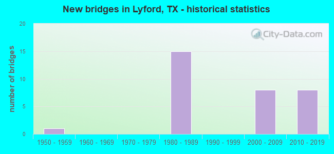
- New bridges - historical statistics
- 11950-1959
- 151980-1989
- 82000-2009
- 82010-2019

- Reconstructed bridges - Historical Statistics
- 11960-1969
- 01970-1979
- 01980-1989
- 01990-1999
- 12000-2009


- Bridge Condition - Deck
- 90.0%Good
- 10.0%Satisfactory

- Bridge Condition - Superstructure
- 35.0%Very good
- 55.0%Good
- 10.0%Satisfactory

- Bridge Condition - Substructure
- 10.0%Very good
- 55.0%Good
- 30.0%Satisfactory
- 5.0%Fair

- Bridge Condition - Channel
- 38.9%Good
- 50.0%Satisfactory
- 5.6%Fair
- 5.6%Poor

- Bridge Condition - Culverts
- 40.0%Good
- 60.0%Satisfactory
Find on map >> Show street view
Structure Number: 212450032706018, Location: 0.01 MI N OF FM 1761 (Lat: 26.519328, Lng: -97.777639), Route carried "on" structure: Business State highway 77, Year Built: 1952, Year Reconstructed: 1972, Status: Open, Structure Length: 3.35m (10.99ft), Average Daily Traffic: 606 (year 2020), Truck Traffic: 25%, Average Future Daily Traffic: 1,560 (year 2031), Design Load: H 20, Features Intersected: WEST MAIN DRAIN
Minimum Vertical Clearance: 30+ m (98+ ft), Kilometerpoint: 8.776, Lanes on structure: 2, Owner: State Highway Agency, Approaching Roadway Width: 12.8m (42.0ft), Material/Design: Concrete continuous, Design/Construction: Slab, Number Of Spans In Main Unit: 5, Length of Maximum Span: 7.6m (24.9ft), Curb-To-Curb Width: 14.6m (47.9ft), Out-to-Out Width: 15.3m (50.2ft)
Condition: Deck: Good, Superstructure: Good, Substructure: Satisfactory, Channel: Fair, Operating Rating: 47.2 metric tons, Method Used To Determine Operating Rating: Load Factor (LF), Inventory Rating: 28.1 metric tons, Method Used To Determine Inventory Rating: Load Factor (LF), Structural Evaluation: Equal to present minimum criteria, Deck Geometry: Superior to present desirable criteria, Waterway Adequacy: Equal to present minimum criteria, Approach Roadway Alignment: Equal to present desirable criteria, Length Of Structure Improvement: 3.35m (10.99ft), Designated Inspection Frequency: Every 24 months, Inspection Date: Febuary 2021, Deck Structure Type: Concrete Cast-file-Place, Wearing Surface/Protective System: Wearing Surface: Bituminous
Find on map >> Show street view
Structure Number: 21245003270704, Location: 0.75 MI S OF FM 498 (Lat: 26.390083, Lng: -97.791072), Route carried "on" structure: Business State highway 77, Year Built: 1984, Status: Open, Structure Length: 4.30m (14.11ft), Average Daily Traffic: 2,150 (year 2011), Truck Traffic: 16%, Average Future Daily Traffic: 3,010 (year 2031), Design Load: HS 20, Features Intersected: HCWID NO 1 MAIN CHANNEL
Minimum Vertical Clearance: 30+ m (98+ ft), Kilometerpoint: 23.210, Lanes on structure: 2, Owner: State Highway Agency, Approaching Roadway Width: 11.6m (38.1ft), Material/Design: Concrete, Design/Construction: Stringer/Multi-beam, Number Of Spans In Main Unit: 4, Length of Maximum Span: 12.2m (40.0ft), Curb-To-Curb Width: 12.4m (40.7ft), Out-to-Out Width: 12.9m (42.3ft)
Condition: Deck: Good, Superstructure: Good, Substructure: Good, Channel: Satisfactory, Operating Rating: 68.0 metric tons, Method Used To Determine Operating Rating: Load Factor (LF), Inventory Rating: 40.8 metric tons, Method Used To Determine Inventory Rating: Load Factor (LF), Structural Evaluation: Better than present minimum criteria, Deck Geometry: Equal to present minimum criteria, Waterway Adequacy: Equal to present minimum criteria, Approach Roadway Alignment: Equal to present desirable criteria, Designated Inspection Frequency: Every 24 months, Inspection Date: Febuary 2021, Deck Structure Type: Concrete Cast-file-Place
Find on map >> Show street view
Structure Number: 212450032707043, Location: 0.80 MI N OF FM 1921 (Lat: 26.434861, Lng: -97.788767), Route carried "on" structure: Business State highway 77, Year Built: 1984, Status: Open, Structure Length: 0.64m (2.10ft), Average Daily Traffic: 4,200 (year 2017), Truck Traffic: 13%, Average Future Daily Traffic: 5,880 (year 2034), Design Load: HS 20, Features Intersected: WILLACY CO DRAIN
Minimum Vertical Clearance: 30+ m (98+ ft), Kilometerpoint: 18.337, Lanes on structure: 2, Owner: State Highway Agency, Approaching Roadway Width: 12.2m (40.0ft), Material/Design: Concrete, Design/Construction: Culvert, Number Of Spans In Main Unit: 2, Length of Maximum Span: 3.0m (9.8ft), Curb-To-Curb Width: 12.2m (40.0ft), Out-to-Out Width: 12.8m (42.0ft)
Condition: Channel: Good, Culverts: Good, Operating Rating: 39.9 metric tons, Method Used To Determine Operating Rating: Load Factor (LF), Inventory Rating: 23.6 metric tons, Method Used To Determine Inventory Rating: Load Factor (LF), Structural Evaluation: Equal to present minimum criteria, Deck Geometry: Equal to present minimum criteria, Waterway Adequacy: Equal to present minimum criteria, Approach Roadway Alignment: Equal to present desirable criteria, Designated Inspection Frequency: Every 48 months, Inspection Date: Febuary 2021, Deck Structure Type: Concrete Cast-file-Place, Wearing Surface/Protective System: Wearing Surface: Bituminous
Find on map >> Show street view
Structure Number: 212450032710041, Location: 0.8 MI S OF FM 498 (Lat: 26.389778, Lng: -97.784458), Route carried "on" structure: US 77, Year Built: 1984, Status: Open, Structure Length: 4.30m (14.11ft), Average Daily Traffic: 5,088 (year 2019), Truck Traffic: 23%, Average Future Daily Traffic: 12,350 (year 2031), Design Load: HS 20, Features Intersected: HCWID NO 1 MAIN CHANNEL
Minimum Vertical Clearance: 30+ m (98+ ft), Kilometerpoint: 39.558, Lanes on structure: 2, Owner: State Highway Agency, Approaching Roadway Width: 12.2m (40.0ft), Material/Design: Concrete, Design/Construction: Stringer/Multi-beam, Number Of Spans In Main Unit: 4, Length of Maximum Span: 12.2m (40.0ft), Curb-To-Curb Width: 12.3m (40.4ft), Out-to-Out Width: 12.9m (42.3ft)
Condition: Deck: Good, Superstructure: Good, Substructure: Good, Channel: Satisfactory, Operating Rating: 68.0 metric tons, Method Used To Determine Operating Rating: Load Factor (LF), Inventory Rating: 40.8 metric tons, Method Used To Determine Inventory Rating: Load Factor (LF), Structural Evaluation: Better than present minimum criteria, Deck Geometry: Better than present minimum criteria, Waterway Adequacy: Equal to present minimum criteria, Approach Roadway Alignment: Equal to present desirable criteria, Designated Inspection Frequency: Every 24 months, Inspection Date: Febuary 2021, Deck Structure Type: Concrete Cast-file-Place
Find on map >> Show street view
Structure Number: 212450032710042, Location: 0.8 MI S OF FM 498 (Lat: 26.390147, Lng: -97.785175), Route carried "on" structure: US 77, Year Built: 1984, Status: Open, Structure Length: 4.30m (14.11ft), Average Daily Traffic: 5,385 (year 2019), Truck Traffic: 23%, Average Future Daily Traffic: 12,350 (year 2031), Design Load: HS 20, Features Intersected: HCWID NO 1 MAIN CHANNEL
Minimum Vertical Clearance: 30+ m (98+ ft), Kilometerpoint: 39.558, Lanes on structure: 2, Owner: State Highway Agency, Approaching Roadway Width: 11.6m (38.1ft), Material/Design: Concrete, Design/Construction: Stringer/Multi-beam, Number Of Spans In Main Unit: 4, Length of Maximum Span: 12.2m (40.0ft), Curb-To-Curb Width: 12.2m (40.0ft), Out-to-Out Width: 12.9m (42.3ft)
Condition: Deck: Good, Superstructure: Good, Substructure: Satisfactory, Channel: Good, Operating Rating: 68.0 metric tons, Method Used To Determine Operating Rating: Load Factor (LF), Inventory Rating: 40.8 metric tons, Method Used To Determine Inventory Rating: Load Factor (LF), Structural Evaluation: Equal to present minimum criteria, Deck Geometry: Better than present minimum criteria, Waterway Adequacy: Equal to present minimum criteria, Approach Roadway Alignment: Equal to present desirable criteria, Designated Inspection Frequency: Every 24 months, Inspection Date: Febuary 2021, Deck Structure Type: Concrete Cast-file-Place
Find on map >> Show street view
Structure Number: 212450032710044, Location: 1.50 MI S OF FM 490 (Lat: 26.433703, Lng: -97.784786), Route carried "on" structure: US 77, Year Built: 1984, Year Reconstructed: 2013, Status: Open, Structure Length: 1.04m (3.41ft), Average Daily Traffic: 5,088 (year 2019), Truck Traffic: 27%, Average Future Daily Traffic: 8,140 (year 2037), Design Load: HS 20, Features Intersected: WILLACY CO DRAIN
Minimum Vertical Clearance: 30+ m (98+ ft), Kilometerpoint: 34.733, Lanes on structure: 8, Owner: State Highway Agency, Approaching Roadway Width: 46.3m (151.9ft), Skew: 30 degrees, Material/Design: Concrete, Design/Construction: Culvert, Number Of Spans In Main Unit: 3, Length of Maximum Span: 3.7m (12.1ft), Curb-To-Curb Width: 46.3m (151.9ft), Out-to-Out Width: 82.3m (270.0ft)
Condition: Channel: Good, Culverts: Good, Operating Rating: 39.9 metric tons, Method Used To Determine Operating Rating: Load Factor (LF), Inventory Rating: 23.6 metric tons, Method Used To Determine Inventory Rating: Load Factor (LF), Structural Evaluation: Somewhat better than minimum adequacy, Deck Geometry: Superior to present desirable criteria, Waterway Adequacy: Equal to present minimum criteria, Approach Roadway Alignment: Equal to present desirable criteria, Designated Inspection Frequency: Every 48 months, Inspection Date: Febuary 2021, Deck Structure Type: Concrete Cast-file-Place, Wearing Surface/Protective System: Wearing Surface: Bituminous
Find on map >> Show street view
Structure Number: 212450032710052, Location: 5.8 MI S OF SH 186 (Lat: 26.400647, Lng: -97.784681), Route carried "on" structure: US 77, Year Built: 2003, Status: Open, Structure Length: 6.10m (20.01ft), Average Daily Traffic: 5,088 (year 2019), Truck Traffic: 23%, Average Future Daily Traffic: 12,350 (year 2031), Design Load: HS 25 or greater, Features Intersected: FM 498
Minimum Vertical Clearance: 30+ m (98+ ft), Kilometerpoint: 38.341, Lanes on structure: 2, Lanes under structure: 6, Owner: State Highway Agency, Approaching Roadway Width: 11.6m (38.1ft), Material/Design: Prestressed concrete, Design/Construction: Stringer/Multi-beam, Number Of Spans In Main Unit: 1, Number Of Approach Spans: 2, Length of Maximum Span: 34.1m (111.9ft), Curb-To-Curb Width: 11.5m (37.7ft), Out-to-Out Width: 12.2m (40.0ft)
Condition: Deck: Good, Superstructure: Very good, Substructure: Good, Operating Rating: 68.0 metric tons, Method Used To Determine Operating Rating: Assigned rating based on Load Factor Design (LFD) reported in metric tons, Inventory Rating: 40.8 metric tons, Method Used To Determine Inventory Rating: Assigned rating based on Load Factor Design (LFD) reported in metric tons, Structural Evaluation: Better than present minimum criteria, Deck Geometry: Equal to present minimum criteria, Underclear: Superior to present desirable criteria, Approach Roadway Alignment: Equal to present desirable criteria, Designated Inspection Frequency: Every 24 months, Inspection Date: Febuary 2021, Deck Structure Type: Concrete Precast Panels
Find on map >> Show street view
Structure Number: 212450032710053, Location: 5.8 MI S OF SH 186 (Lat: 26.401122, Lng: -97.785042), Route carried "on" structure: US 77, Year Built: 2003, Status: Open, Structure Length: 6.10m (20.01ft), Average Daily Traffic: 5,385 (year 2019), Truck Traffic: 23%, Average Future Daily Traffic: 12,350 (year 2031), Design Load: HS 25 or greater, Features Intersected: FM 498
Minimum Vertical Clearance: 30+ m (98+ ft), Kilometerpoint: 38.341, Lanes on structure: 2, Lanes under structure: 6, Owner: State Highway Agency, Approaching Roadway Width: 11.6m (38.1ft), Material/Design: Prestressed concrete, Design/Construction: Stringer/Multi-beam, Number Of Spans In Main Unit: 1, Number Of Approach Spans: 2, Length of Maximum Span: 34.1m (111.9ft), Curb-To-Curb Width: 11.5m (37.7ft), Out-to-Out Width: 12.2m (40.0ft)
Condition: Deck: Good, Superstructure: Very good, Substructure: Good, Operating Rating: 68.0 metric tons, Method Used To Determine Operating Rating: Assigned rating based on Load Factor Design (LFD) reported in metric tons, Inventory Rating: 40.8 metric tons, Method Used To Determine Inventory Rating: Assigned rating based on Load Factor Design (LFD) reported in metric tons, Structural Evaluation: Better than present minimum criteria, Deck Geometry: Equal to present minimum criteria, Underclear: Superior to present desirable criteria, Approach Roadway Alignment: Equal to present desirable criteria, Designated Inspection Frequency: Every 24 months, Inspection Date: Febuary 2021, Deck Structure Type: Concrete Precast Panels
Find on map >> Show street view
Structure Number: 212450032710054, Location: 5.2 MI S OF SH 186 (Lat: 26.409206, Lng: -97.784778), Route carried "on" structure: US 77, Year Built: 2003, Status: Open, Structure Length: 31.88m (104.59ft), Average Daily Traffic: 5,088 (year 2019), Truck Traffic: 23%, Average Future Daily Traffic: 12,230 (year 2031), Design Load: HS 25 or greater, Features Intersected: SPUR 112
Minimum Vertical Clearance: 30+ m (98+ ft), Kilometerpoint: 37.132, Lanes on structure: 2, Lanes under structure: 6, Owner: State Highway Agency, Approaching Roadway Width: 11.6m (38.1ft), Material/Design: Prestressed concrete, Design/Construction: Stringer/Multi-beam, Number Of Spans In Main Unit: 10, Length of Maximum Span: 34.1m (111.9ft), Curb-To-Curb Width: 11.5m (37.7ft), Out-to-Out Width: 12.2m (40.0ft)
Condition: Deck: Good, Superstructure: Good, Substructure: Good, Operating Rating: 68.0 metric tons, Method Used To Determine Operating Rating: Assigned rating based on Load Factor Design (LFD) reported in metric tons, Inventory Rating: 40.8 metric tons, Method Used To Determine Inventory Rating: Assigned rating based on Load Factor Design (LFD) reported in metric tons, Structural Evaluation: Better than present minimum criteria, Deck Geometry: Equal to present minimum criteria, Underclear: Superior to present desirable criteria, Approach Roadway Alignment: Equal to present desirable criteria, Designated Inspection Frequency: Every 24 months, Inspection Date: Febuary 2021, Deck Structure Type: Concrete Precast Panels
Find on map >> Show street view
Structure Number: 212450032710055, Location: 5.2 MI S OF SH 186 (Lat: 26.412006, Lng: -97.785150), Route carried "on" structure: US 77, Year Built: 2003, Status: Open, Structure Length: 32.03m (105.09ft), Average Daily Traffic: 5,385 (year 2019), Truck Traffic: 23%, Average Future Daily Traffic: 12,230 (year 2031), Design Load: HS 25 or greater, Features Intersected: SPUR 112
Minimum Vertical Clearance: 30+ m (98+ ft), Kilometerpoint: 37.132, Lanes on structure: 2, Lanes under structure: 6, Owner: State Highway Agency, Approaching Roadway Width: 11.6m (38.1ft), Material/Design: Prestressed concrete, Design/Construction: Stringer/Multi-beam, Number Of Spans In Main Unit: 10, Length of Maximum Span: 35.4m (116.1ft), Curb-To-Curb Width: 11.5m (37.7ft), Out-to-Out Width: 12.2m (40.0ft)
Condition: Deck: Good, Superstructure: Good, Substructure: Good, Operating Rating: 68.0 metric tons, Method Used To Determine Operating Rating: Assigned rating based on Load Factor Design (LFD) reported in metric tons, Inventory Rating: 40.8 metric tons, Method Used To Determine Inventory Rating: Assigned rating based on Load Factor Design (LFD) reported in metric tons, Structural Evaluation: Better than present minimum criteria, Deck Geometry: Equal to present minimum criteria, Underclear: Superior to present desirable criteria, Approach Roadway Alignment: Equal to present desirable criteria, Designated Inspection Frequency: Every 24 months, Inspection Date: Febuary 2021, Deck Structure Type: Concrete Precast Panels
Find on map >> Show street view
Structure Number: 212450032710218, Location: 0.75 MI S OF FM 498 (Lat: 26.390167, Lng: -97.784750), Route carried "on" structure: US 77, Year Built: 2013, Status: Open, Structure Length: 4.27m (14.01ft), Average Daily Traffic: 5,088 (year 2019), Truck Traffic: 5%, Average Future Daily Traffic: 12,000 (year 2031), Design Load: HL 93, Features Intersected: HCWID # 1 MAIN CHANNEL
Minimum Vertical Clearance: 30+ m (98+ ft), Kilometerpoint: 0.002, Lanes on structure: 2, Owner: State Highway Agency, Approaching Roadway Width: 11.6m (38.1ft), Material/Design: Prestressed concrete, Design/Construction: Stringer/Multi-beam, Number Of Spans In Main Unit: 2, Length of Maximum Span: 21.3m (69.9ft), Curb-To-Curb Width: 11.5m (37.7ft), Out-to-Out Width: 12.2m (40.0ft)
Condition: Deck: Good, Superstructure: Very good, Substructure: Very good, Channel: Good, Operating Rating: 54.4 metric tons, Method Used To Determine Operating Rating: Assigned ratings based on Load and Resistance Factor Design (LRFD) reported in metric tons, Inventory Rating: 32.7 metric tons, Method Used To Determine Inventory Rating: Assigned ratings based on Load and Resistance Factor Design (LRFD) reported in metric tons, Structural Evaluation: Equal to present desirable criteria, Deck Geometry: Somewhat better than minimum adequacy, Waterway Adequacy: Superior to present desirable criteria, Approach Roadway Alignment: Equal to present desirable criteria, Designated Inspection Frequency: Every 24 months, Inspection Date: Febuary 2021, Deck Structure Type: Concrete Precast Panels
Find on map >> Show street view
Structure Number: 212450032710219, Location: 0.75 MI S OF FM 498 (Lat: 26.390144, Lng: -97.784969), Route carried "on" structure: US 77, Year Built: 2013, Status: Open, Structure Length: 4.27m (14.01ft), Average Daily Traffic: 5,385 (year 2019), Truck Traffic: 5%, Average Future Daily Traffic: 12,000 (year 2031), Design Load: HL 93, Features Intersected: HCWID # 1 MAIN CHANNEL
Minimum Vertical Clearance: 30+ m (98+ ft), Kilometerpoint: 0.002, Lanes on structure: 2, Owner: State Highway Agency, Approaching Roadway Width: 11.6m (38.1ft), Material/Design: Prestressed concrete, Design/Construction: Stringer/Multi-beam, Number Of Spans In Main Unit: 2, Length of Maximum Span: 21.3m (69.9ft), Curb-To-Curb Width: 11.4m (37.4ft), Out-to-Out Width: 12.2m (40.0ft)
Condition: Deck: Good, Superstructure: Very good, Substructure: Very good, Channel: Good, Operating Rating: 54.4 metric tons, Method Used To Determine Operating Rating: Assigned ratings based on Load and Resistance Factor Design (LRFD) reported in metric tons, Inventory Rating: 32.7 metric tons, Method Used To Determine Inventory Rating: Assigned ratings based on Load and Resistance Factor Design (LRFD) reported in metric tons, Structural Evaluation: Equal to present desirable criteria, Deck Geometry: Somewhat better than minimum adequacy, Waterway Adequacy: Superior to present desirable criteria, Approach Roadway Alignment: Equal to present desirable criteria, Designated Inspection Frequency: Every 24 months, Inspection Date: Febuary 2021, Deck Structure Type: Concrete Precast Panels
Find on map >> Show street view
Structure Number: 21245003271022, Location: 1.15 MI S OF FM 490 (Lat: 26.437419, Lng: -97.784983), Route carried "on" structure: US 77, Year Built: 2013, Status: Open, Structure Length: 6.10m (20.01ft), Average Daily Traffic: 5,088 (year 2019), Truck Traffic: 5%, Average Future Daily Traffic: 23,900 (year 2031), Design Load: HL 93, Features Intersected: SPUR 56
Minimum Vertical Clearance: 30+ m (98+ ft), Kilometerpoint: 0.002, Lanes on structure: 2, Lanes under structure: 6, Owner: State Highway Agency, Approaching Roadway Width: 11.6m (38.1ft), Material/Design: Prestressed concrete, Design/Construction: Stringer/Multi-beam, Number Of Spans In Main Unit: 1, Number Of Approach Spans: 2, Length of Maximum Span: 34.1m (111.9ft), Curb-To-Curb Width: 11.4m (37.4ft), Out-to-Out Width: 12.2m (40.0ft)
Condition: Deck: Good, Superstructure: Very good, Substructure: Good, Operating Rating: 54.4 metric tons, Method Used To Determine Operating Rating: Assigned ratings based on Load and Resistance Factor Design (LRFD) reported in metric tons, Inventory Rating: 32.7 metric tons, Method Used To Determine Inventory Rating: Assigned ratings based on Load and Resistance Factor Design (LRFD) reported in metric tons, Structural Evaluation: Better than present minimum criteria, Deck Geometry: Somewhat better than minimum adequacy, Underclear: Superior to present desirable criteria, Approach Roadway Alignment: Equal to present desirable criteria, Designated Inspection Frequency: Every 24 months, Inspection Date: Febuary 2021, Deck Structure Type: Concrete Precast Panels
Find on map >> Show street view
Structure Number: 212450032710221, Location: 1.15 MI S OF FM 490 (Lat: 26.437436, Lng: -97.785219), Route carried "on" structure: US 77, Year Built: 2013, Status: Open, Structure Length: 6.10m (20.01ft), Average Daily Traffic: 5,385 (year 2019), Truck Traffic: 5%, Average Future Daily Traffic: 23,900 (year 2031), Design Load: HL 93, Features Intersected: SPUR 56
Minimum Vertical Clearance: 30+ m (98+ ft), Kilometerpoint: 0.000, Lanes on structure: 2, Lanes under structure: 6, Owner: State Highway Agency, Approaching Roadway Width: 11.6m (38.1ft), Material/Design: Prestressed concrete, Design/Construction: Stringer/Multi-beam, Number Of Spans In Main Unit: 1, Number Of Approach Spans: 2, Length of Maximum Span: 34.1m (111.9ft), Curb-To-Curb Width: 11.4m (37.4ft), Out-to-Out Width: 12.2m (40.0ft)
Condition: Deck: Good, Superstructure: Very good, Substructure: Good, Operating Rating: 54.4 metric tons, Method Used To Determine Operating Rating: Assigned ratings based on Load and Resistance Factor Design (LRFD) reported in metric tons, Inventory Rating: 32.7 metric tons, Method Used To Determine Inventory Rating: Assigned ratings based on Load and Resistance Factor Design (LRFD) reported in metric tons, Structural Evaluation: Better than present minimum criteria, Deck Geometry: Somewhat better than minimum adequacy, Underclear: Superior to present desirable criteria, Approach Roadway Alignment: Equal to present desirable criteria, Designated Inspection Frequency: Every 24 months, Inspection Date: Febuary 2021, Deck Structure Type: Concrete Precast Panels
Find on map >> Show street view
Structure Number: 212450032710222, Location: 1.50 MI N OF FM 1018 (Lat: 26.379019, Lng: -97.784122), Route carried "on" structure: County highway , Year Built: 2013, Status: Open, Structure Length: 15.54m (50.98ft), Average Daily Traffic: 250 (year 2012), Average Future Daily Traffic: 550 (year 2032), Design Load: HL 93, Features Intersected: US 77, Facility Carried by Structure: LILY ROAD
Minimum Vertical Clearance: 30+ m (98+ ft), Kilometerpoint: 0.000, Lanes on structure: 2, Lanes under structure: 8, Owner: State Highway Agency, Approaching Roadway Width: 13.4m (44.0ft), Material/Design: Prestressed concrete, Design/Construction: Stringer/Multi-beam, Number Of Spans In Main Unit: 6, Length of Maximum Span: 27.4m (89.9ft), Curb-To-Curb Width: 13.3m (43.6ft), Out-to-Out Width: 14.0m (45.9ft)
Condition: Deck: Good, Superstructure: Very good, Substructure: Good, Operating Rating: 54.4 metric tons, Method Used To Determine Operating Rating: Assigned ratings based on Load and Resistance Factor Design (LRFD) reported in metric tons, Inventory Rating: 32.7 metric tons, Method Used To Determine Inventory Rating: Assigned ratings based on Load and Resistance Factor Design (LRFD) reported in metric tons, Structural Evaluation: Better than present minimum criteria, Deck Geometry: Superior to present desirable criteria, Underclear: Somewhat better than minimum adequacy, Approach Roadway Alignment: Equal to present desirable criteria, Designated Inspection Frequency: Every 24 months, Inspection Date: Febuary 2021, Deck Structure Type: Concrete Precast Panels
Find on map >> Show street view
Structure Number: 212450AA0142001, Location: 1.0 MI E OF JCT US 77 (Lat: 26.430019, Lng: -97.768128), Route carried "on" structure: County highway 2200, Year Built: 1984, Status: Open, Structure Length: 1.28m (4.20ft), Average Daily Traffic: 50 (year 2010), Average Future Daily Traffic: 95 (year 2030), Features Intersected: WILLACY MAIN DRAIN
Minimum Vertical Clearance: 30+ m (98+ ft), Kilometerpoint: 1.609, Lanes on structure: 2, Owner: County Highway Agency, Approaching Roadway Width: 3.0m (9.8ft), Material/Design: Prestressed concrete, Design/Construction: Box Beam or Girders - Multiple, Number Of Spans In Main Unit: 1, Length of Maximum Span: 12.2m (40.0ft), Curb-To-Curb Width: 7.9m (25.9ft), Out-to-Out Width: 8.5m (27.9ft)
Condition: Deck: Good, Superstructure: Good, Substructure: Satisfactory, Channel: Satisfactory, Operating Rating: 32.7 metric tons, Method Used To Determine Operating Rating: Field evaluation and documented engineering judgment, Inventory Rating: 24.5 metric tons, Method Used To Determine Inventory Rating: Field evaluation and documented engineering judgment, Structural Evaluation: Equal to present minimum criteria, Deck Geometry: Equal to present minimum criteria, Waterway Adequacy: Better than present minimum criteria, Approach Roadway Alignment: Equal to present desirable criteria, Designated Inspection Frequency: Every 24 months, Inspection Date: April 2020, Deck Structure Type: Concrete Precast Panels
Find on map >> Show street view
Structure Number: 212450AA0199001, Location: 1.5 MI E OF JCT US 77 (Lat: 26.422803, Lng: -97.760139), Route carried "on" structure: County highway 2100, Year Built: 1984, Status: Open, Structure Length: 1.28m (4.20ft), Average Daily Traffic: 100 (year 2019), Average Future Daily Traffic: 45 (year 2030), Features Intersected: WILLACY MAIN DRAIN
Minimum Vertical Clearance: 30+ m (98+ ft), Kilometerpoint: 2.414, Lanes on structure: 2, Owner: County Highway Agency, Approaching Roadway Width: 3.7m (12.1ft), Material/Design: Prestressed concrete, Design/Construction: Box Beam or Girders - Multiple, Number Of Spans In Main Unit: 1, Length of Maximum Span: 12.2m (40.0ft), Curb-To-Curb Width: 7.9m (25.9ft), Out-to-Out Width: 8.4m (27.6ft)
Condition: Deck: Satisfactory, Superstructure: Satisfactory, Substructure: Fair, Channel: Poor, Operating Rating: 32.7 metric tons, Method Used To Determine Operating Rating: Field evaluation and documented engineering judgment, Inventory Rating: 24.5 metric tons, Method Used To Determine Inventory Rating: Field evaluation and documented engineering judgment, Structural Evaluation: Somewhat better than minimum adequacy, Deck Geometry: Equal to present minimum criteria, Waterway Adequacy: Better than present minimum criteria, Approach Roadway Alignment: Equal to present desirable criteria, Designated Inspection Frequency: Every 24 months, Inspection Date: April 2020, Deck Structure Type: Concrete Precast Panels
Find on map >> Show street view
Structure Number: 212450AA0202001, Location: 2.2 MI N OF JCT FM 498 (Lat: 26.433597, Lng: -97.781411), Route carried "on" structure: County highway 215, Year Built: 1984, Status: Open, Structure Length: 0.70m (2.30ft), Average Daily Traffic: 3,264 (year 2014), Average Future Daily Traffic: 65 (year 2030), Features Intersected: WILLACY MAIN DRAIN
Minimum Vertical Clearance: 30+ m (98+ ft), Kilometerpoint: 3.541, Lanes on structure: 2, Owner: County Highway Agency, Approaching Roadway Width: 5.5m (18.0ft), Material/Design: Concrete, Design/Construction: Culvert, Number Of Spans In Main Unit: 2, Length of Maximum Span: 3.0m (9.8ft), Curb-To-Curb Width: 11.6m (38.1ft), Out-to-Out Width: 12.3m (40.4ft)
Condition: Channel: Good, Culverts: Satisfactory, Operating Rating: 39.9 metric tons, Method Used To Determine Operating Rating: Load Factor (LF), Inventory Rating: 23.6 metric tons, Method Used To Determine Inventory Rating: Load Factor (LF), Structural Evaluation: Equal to present minimum criteria, Deck Geometry: Somewhat better than minimum adequacy, Waterway Adequacy: Better than present minimum criteria, Approach Roadway Alignment: Equal to present desirable criteria, Designated Inspection Frequency: Every 24 months, Inspection Date: April 2020, Deck Structure Type: Concrete Cast-file-Place, Wearing Surface/Protective System: Wearing Surface: Gravel
Find on map >> Show street view
Structure Number: 212450AA0232001, Location: 0.5 MI S OF JCT FM 498 (Lat: 26.393594, Lng: -97.735628), Route carried "on" structure: County highway 330, Year Built: 1984, Status: Posted for load, Structure Length: 4.63m (15.19ft), Average Daily Traffic: 100 (year 2019), Average Future Daily Traffic: 110 (year 2030), Features Intersected: HILD DD#1 MAIN CHANNEL
Minimum Vertical Clearance: 30+ m (98+ ft), Kilometerpoint: 4.023, Lanes on structure: 2, Owner: County Highway Agency, Approaching Roadway Width: 4.9m (16.1ft), Material/Design: Concrete, Design/Construction: Stringer/Multi-beam, Number Of Spans In Main Unit: 5, Length of Maximum Span: 9.1m (29.9ft), Curb-To-Curb Width: 7.9m (25.9ft), Out-to-Out Width: 8.5m (27.9ft)
Condition: Deck: Good, Superstructure: Good, Substructure: Satisfactory, Channel: Satisfactory, Operating Rating: 32.7 metric tons, Method Used To Determine Operating Rating: Field evaluation and documented engineering judgment, Inventory Rating: 24.5 metric tons, Method Used To Determine Inventory Rating: Field evaluation and documented engineering judgment, Structural Evaluation: Equal to present minimum criteria, Deck Geometry: Equal to present minimum criteria, Waterway Adequacy: Better than present minimum criteria, Approach Roadway Alignment: Equal to present desirable criteria, Bridge Posting: Required (Relationship of Operating Rating to Maximum Legal Load: 0.1 - 9.9% below), Designated Inspection Frequency: Every 24 months, Inspection Date: April 2020, Deck Structure Type: Concrete Cast-file-Place
Find on map >> Show street view
Structure Number: 212450AA0232002, Location: 1.3 MI N OF JCT FM 498 (Lat: 26.422517, Lng: -97.735606), Route carried "on" structure: County highway 232, Year Built: 1984, Status: Open, Structure Length: 0.70m (2.30ft), Average Daily Traffic: 20 (year 2010), Average Future Daily Traffic: 110 (year 2030), Features Intersected: WILLACY MAIN DRAIN, Facility Carried by Structure: CR 330 S
Minimum Vertical Clearance: 30+ m (98+ ft), Kilometerpoint: 7.001, Lanes on structure: 2, Owner: County Highway Agency, Approaching Roadway Width: 3.7m (12.1ft), Material/Design: Concrete, Design/Construction: Culvert, Number Of Spans In Main Unit: 2, Length of Maximum Span: 3.0m (9.8ft), Curb-To-Curb Width: 11.6m (38.1ft), Out-to-Out Width: 12.2m (40.0ft)
Condition: Channel: Good, Culverts: Satisfactory, Operating Rating: 32.7 metric tons, Method Used To Determine Operating Rating: Field evaluation and documented engineering judgment, Inventory Rating: 24.5 metric tons, Method Used To Determine Inventory Rating: Field evaluation and documented engineering judgment, Structural Evaluation: Equal to present minimum criteria, Deck Geometry: Superior to present desirable criteria, Waterway Adequacy: Better than present minimum criteria, Approach Roadway Alignment: Equal to present desirable criteria, Designated Inspection Frequency: Every 24 months, Inspection Date: April 2020, Deck Structure Type: Concrete Cast-file-Place, Wearing Surface/Protective System: Wearing Surface: Gravel
Find on map >> Show street view
Structure Number: 212450AA0234001, Location: 0.67 MI S OF JCT FM 498 (Lat: 26.390339, Lng: -97.751778), Route carried "on" structure: County highway 315, Year Built: 1984, Status: Posted for load, Structure Length: 4.63m (15.19ft), Average Daily Traffic: 50 (year 2010), Average Future Daily Traffic: 110 (year 2030), Features Intersected: HIDAL DD#1 MAIN CHANNEL
Minimum Vertical Clearance: 30+ m (98+ ft), Kilometerpoint: 5.472, Lanes on structure: 2, Owner: County Highway Agency, Approaching Roadway Width: 4.9m (16.1ft), Material/Design: Concrete, Design/Construction: Stringer/Multi-beam, Number Of Spans In Main Unit: 5, Length of Maximum Span: 9.1m (29.9ft), Curb-To-Curb Width: 7.9m (25.9ft), Out-to-Out Width: 8.5m (27.9ft)
Condition: Deck: Good, Superstructure: Good, Substructure: Satisfactory, Channel: Satisfactory, Operating Rating: 32.7 metric tons, Method Used To Determine Operating Rating: Field evaluation and documented engineering judgment, Inventory Rating: 24.5 metric tons, Method Used To Determine Inventory Rating: Field evaluation and documented engineering judgment, Structural Evaluation: Equal to present minimum criteria, Deck Geometry: Equal to present minimum criteria, Waterway Adequacy: Better than present minimum criteria, Approach Roadway Alignment: Equal to present desirable criteria, Bridge Posting: Required (Relationship of Operating Rating to Maximum Legal Load: 0.1 - 9.9% below), Designated Inspection Frequency: Every 24 months, Inspection Date: April 2020, Deck Structure Type: Concrete Cast-file-Place
Find on map >> Show street view
Structure Number: 212450AA0234002, Location: 1.3 MI N OF JCT FM 498 (Lat: 26.422528, Lng: -97.751758), Route carried "on" structure: County highway 315, Year Built: 1984, Status: Open, Structure Length: 0.70m (2.30ft), Average Daily Traffic: 100 (year 2019), Average Future Daily Traffic: 130 (year 2030), Features Intersected: WILLACY MAIN DRAIN
Minimum Vertical Clearance: 30+ m (98+ ft), Kilometerpoint: 3.701, Lanes on structure: 2, Owner: County Highway Agency, Approaching Roadway Width: 4.9m (16.1ft), Material/Design: Concrete, Design/Construction: Culvert, Number Of Spans In Main Unit: 2, Length of Maximum Span: 3.0m (9.8ft)
Condition: Channel: Satisfactory, Culverts: Satisfactory, Operating Rating: 32.7 metric tons, Method Used To Determine Operating Rating: Field evaluation and documented engineering judgment, Inventory Rating: 24.5 metric tons, Method Used To Determine Inventory Rating: Field evaluation and documented engineering judgment, Structural Evaluation: Equal to present minimum criteria, Waterway Adequacy: Better than present minimum criteria, Approach Roadway Alignment: Equal to present desirable criteria, Designated Inspection Frequency: Every 24 months, Inspection Date: April 2020
Find on map >> Show street view
Structure Number: 212450AA0250001, Location: 0.7 MI S OF JCT FM 498 (Lat: 26.390256, Lng: -97.781022), Route carried "on" structure: County highway 215, Year Built: 1983, Status: Posted for load, Structure Length: 4.63m (15.19ft), Average Daily Traffic: 50 (year 2010), Average Future Daily Traffic: 110 (year 2030), Features Intersected: HIDAL DD#1 MAIN CHANNEL
Minimum Vertical Clearance: 30+ m (98+ ft), Kilometerpoint: 5.955, Lanes on structure: 2, Owner: County Highway Agency, Approaching Roadway Width: 4.9m (16.1ft), Material/Design: Concrete, Design/Construction: Stringer/Multi-beam, Number Of Spans In Main Unit: 5, Length of Maximum Span: 9.1m (29.9ft), Curb-To-Curb Width: 7.9m (25.9ft), Out-to-Out Width: 8.5m (27.9ft)
Condition: Deck: Satisfactory, Superstructure: Satisfactory, Substructure: Satisfactory, Channel: Satisfactory, Operating Rating: 32.7 metric tons, Method Used To Determine Operating Rating: Field evaluation and documented engineering judgment, Inventory Rating: 24.5 metric tons, Method Used To Determine Inventory Rating: Field evaluation and documented engineering judgment, Structural Evaluation: Equal to present minimum criteria, Deck Geometry: Equal to present minimum criteria, Waterway Adequacy: Better than present minimum criteria, Approach Roadway Alignment: Equal to present desirable criteria, Bridge Posting: Required (Relationship of Operating Rating to Maximum Legal Load: 0.1 - 9.9% below), Designated Inspection Frequency: Every 24 months, Inspection Date: April 2020, Deck Structure Type: Concrete Cast-file-Place
Find on map >> Show street view
Structure Number: 212450AA0254001, Location: 0.25 MI S OF JCT FM 491 (Lat: 26.389719, Lng: -97.797144), Route carried "on" structure: County highway 200, Year Built: 1983, Status: Posted for load, Structure Length: 4.63m (15.19ft), Average Daily Traffic: 100 (year 2019), Average Future Daily Traffic: 110 (year 2030), Features Intersected: HIDAL DD#1 MAIN CHANNEL
Minimum Vertical Clearance: 30+ m (98+ ft), Kilometerpoint: 3.701, Lanes on structure: 2, Owner: County Highway Agency, Approaching Roadway Width: 4.9m (16.1ft), Material/Design: Concrete, Design/Construction: Stringer/Multi-beam, Number Of Spans In Main Unit: 5, Length of Maximum Span: 9.1m (29.9ft), Curb-To-Curb Width: 7.9m (25.9ft), Out-to-Out Width: 8.5m (27.9ft)
Condition: Deck: Good, Superstructure: Good, Substructure: Good, Channel: Satisfactory, Operating Rating: 32.7 metric tons, Method Used To Determine Operating Rating: Field evaluation and documented engineering judgment, Inventory Rating: 24.5 metric tons, Method Used To Determine Inventory Rating: Field evaluation and documented engineering judgment, Structural Evaluation: Equal to present minimum criteria, Deck Geometry: Equal to present minimum criteria, Waterway Adequacy: Better than present minimum criteria, Approach Roadway Alignment: Equal to present desirable criteria, Bridge Posting: Required (Relationship of Operating Rating to Maximum Legal Load: 0.1 - 9.9% below), Designated Inspection Frequency: Every 24 months, Inspection Date: April 2020, Deck Structure Type: Concrete Cast-file-Place
Find on map >> Show street view
Structure Number: 212450AA0276001, Location: 0.95 MI W OF JCT US 77 (Lat: 26.386264, Lng: -97.800892), Route carried "on" structure: County highway 1600, Year Built: 1983, Status: Posted for load, Structure Length: 4.63m (15.19ft), Average Daily Traffic: 50 (year 2010), Average Future Daily Traffic: 110 (year 2030), Features Intersected: HIDAL DD#1 MAIN CHANNEL
Minimum Vertical Clearance: 30+ m (98+ ft), Kilometerpoint: 1.529, Lanes on structure: 2, Owner: County Highway Agency, Approaching Roadway Width: 5.5m (18.0ft), Material/Design: Concrete, Design/Construction: Stringer/Multi-beam, Number Of Spans In Main Unit: 5, Length of Maximum Span: 9.1m (29.9ft), Curb-To-Curb Width: 7.9m (25.9ft), Out-to-Out Width: 8.5m (27.9ft)
Condition: Deck: Good, Superstructure: Good, Substructure: Good, Channel: Satisfactory, Operating Rating: 32.7 metric tons, Method Used To Determine Operating Rating: Field evaluation and documented engineering judgment, Inventory Rating: 24.5 metric tons, Method Used To Determine Inventory Rating: Field evaluation and documented engineering judgment, Structural Evaluation: Equal to present minimum criteria, Deck Geometry: Equal to present minimum criteria, Waterway Adequacy: Better than present minimum criteria, Approach Roadway Alignment: Equal to present desirable criteria, Bridge Posting: Required (Relationship of Operating Rating to Maximum Legal Load: 0.1 - 9.9% below), Designated Inspection Frequency: Every 24 months, Inspection Date: April 2020, Deck Structure Type: Concrete Cast-file-Place
Find on map >> Show street view
Structure Number: 212450032710052, Location: 5.8 MI S OF SH 186 (Lat: 26.400647, Lng: -97.784681), Route carried "under" structure: State highway 498, Year Built: 2003, Structure Length: 0. m, Average Daily Traffic: 150 (year 2011), Truck Traffic: 22%, Features Intersected: FM 498, Facility Carried by Structure: US 77 NB
Minimum Vertical Clearance: 5.31m (17.42ft), Kilometerpoint: 0.573, Lanes on structure: 2, Lanes under structure: 6, Material/Design: Prestressed concrete, Design/Construction: Stringer/Multi-beam, Length of Maximum Span: 34.1m (111.9ft)
Find on map >> Show street view
Structure Number: 212450032710053, Location: 5.8 MI S OF SH 186 (Lat: 26.401122, Lng: -97.785042), Route carried "under" structure: State highway 498, Year Built: 2003, Structure Length: 0. m, Average Daily Traffic: 150 (year 2011), Truck Traffic: 22%, Features Intersected: FM 498, Facility Carried by Structure: US 77 SB
Minimum Vertical Clearance: 5.28m (17.32ft), Kilometerpoint: 0.550, Lanes on structure: 2, Lanes under structure: 6, Material/Design: Prestressed concrete, Design/Construction: Stringer/Multi-beam, Length of Maximum Span: 34.1m (111.9ft)
Find on map >> Show street view
Structure Number: 212450032710054, Location: 5.2 MI S OF SH 186 (Lat: 26.409206, Lng: -97.784778), Route carried "under" structure: Spur State highway 112, Year Built: 2003, Structure Length: 0. m, Average Daily Traffic: 120 (year 2011), Truck Traffic: 5%, Features Intersected: SPUR 112, Facility Carried by Structure: US 77 NB
Minimum Vertical Clearance: 5.36m (17.59ft), Kilometerpoint: 0.525, Lanes on structure: 2, Lanes under structure: 6, Material/Design: Prestressed concrete, Design/Construction: Stringer/Multi-beam, Length of Maximum Span: 34.1m (111.9ft)
Find on map >> Show street view
Structure Number: 212450032710055, Location: 5.2 MI S OF SH 186 (Lat: 26.412006, Lng: -97.785150), Route carried "under" structure: Spur State highway 112, Year Built: 2003, Structure Length: 0. m, Average Daily Traffic: 120 (year 2011), Truck Traffic: 5%, Features Intersected: SPUR 112, Facility Carried by Structure: US 77 SB
Minimum Vertical Clearance: 5.16m (16.93ft), Kilometerpoint: 0.504, Lanes on structure: 2, Lanes under structure: 6, Material/Design: Prestressed concrete, Design/Construction: Stringer/Multi-beam, Length of Maximum Span: 35.4m (116.1ft)
Find on map >> Show street view
Structure Number: 21245003271022, Location: 1.15 MI S OF FM 490 (Lat: 26.437419, Lng: -97.784983), Route carried "under" structure: Spur State highway 56, Year Built: 2013, Structure Length: 0. m, Average Daily Traffic: 760 (year 2012), Truck Traffic: 1%, Features Intersected: SPUR 56, Facility Carried by Structure: US 77 NB
Minimum Vertical Clearance: 5.33m (17.49ft), Kilometerpoint: 0.381, Lanes on structure: 2, Lanes under structure: 4, Material/Design: Prestressed concrete, Design/Construction: Stringer/Multi-beam, Length of Maximum Span: 34.1m (111.9ft)
Find on map >> Show street view
Structure Number: 212450032710221, Location: 1.15 MI S OF FM 490 (Lat: 26.437436, Lng: -97.785219), Route carried "under" structure: Spur State highway 56, Year Built: 2013, Structure Length: 0. m, Average Daily Traffic: 760 (year 2012), Truck Traffic: 1%, Features Intersected: SPUR 56, Facility Carried by Structure: US 77 SB
Minimum Vertical Clearance: 5.36m (17.59ft), Kilometerpoint: 0.381, Lanes on structure: 2, Lanes under structure: 4, Material/Design: Prestressed concrete, Design/Construction: Stringer/Multi-beam, Length of Maximum Span: 34.1m (111.9ft)
Find on map >> Show street view
Structure Number: 212450032710222, Location: 1.50 MI N OF FM 1018 (Lat: 26.379019, Lng: -97.784122), Route carried "under" structure: US 77, Year Built: 2013, Structure Length: 0. m, Average Daily Traffic: 15,900 (year 2012), Truck Traffic: 5%, Features Intersected: US 77, Facility Carried by Structure: LILY ROAD
Minimum Vertical Clearance: 5.59m (18.34ft), Kilometerpoint: 0.000, Lanes on structure: 8, Material/Design: Prestressed concrete, Design/Construction: Stringer/Multi-beam, Length of Maximum Span: 27.4m (89.9ft)