Bridge Statistics for Lyman, Wyoming (WY)
Condition, Traffic, Stress, Structural Evaluation, Project Costs
- National Bridge Inventory (NBI) Statistics
- 14Number of bridges
- 131ft / 39.6mTotal length
- $322,000Total costs
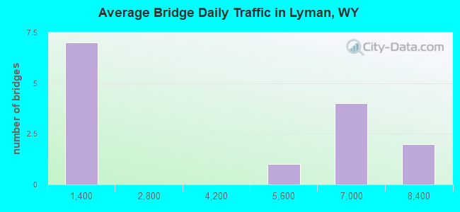
- 47,898Total average daily traffic
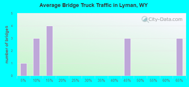
- 21,494Total average daily truck traffic
- National Bridge Inventory (NBI) Registered Bridges for Lyman
- No street view available for this location
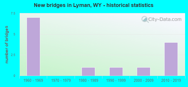
- New bridges - historical statistics
- 71960-1969
- 11980-1989
- 11990-1999
- 12000-2009
- 42010-2019
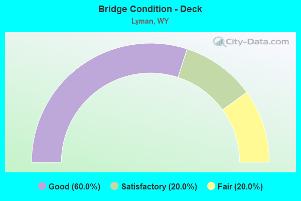
- Bridge Condition - Deck
- 60.0%Good
- 20.0%Satisfactory
- 20.0%Fair
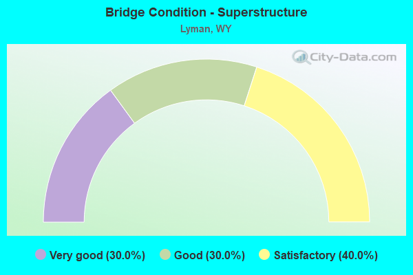
- Bridge Condition - Superstructure
- 30.0%Very good
- 30.0%Good
- 40.0%Satisfactory
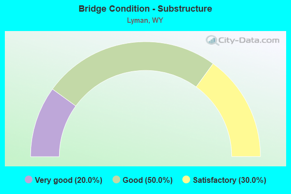
- Bridge Condition - Substructure
- 20.0%Very good
- 50.0%Good
- 30.0%Satisfactory
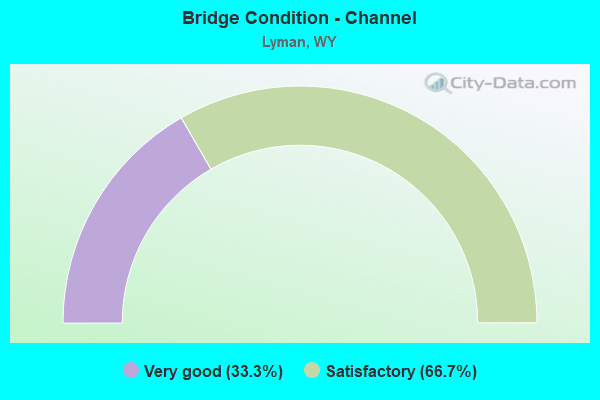
- Bridge Condition - Channel
- 33.3%Very good
- 66.7%Satisfactory
Find on map >> Show street view
Structure Number: ANQ, Location: Wyo 410 Jct (Lat: 41.356533, Lng: -110.338089), Route carried "on" structure: Interstate 80, Year Built: 1968, Status: Open, Structure Length: 4.69m (15.39ft), Average Daily Traffic: 5,841 (year 2021), Truck Traffic: 64%, Average Future Daily Traffic: 8,177 (year 2041), Design Load: HS 20+Mod, Features Intersected: WYO 414
Minimum Vertical Clearance: 30+ m (98+ ft), Kilometerpoint: 64.169, Lanes on structure: 2, Lanes under structure: 2, Base Highway Network: Yes (Inventory Route: ML8, Subroute: 1), Owner: State Highway Agency, Approaching Roadway Width: 11.6m (38.1ft), Skew: 10 degrees, Material/Design: Steel continuous, Design/Construction: Stringer/Multi-beam, Number Of Spans In Main Unit: 3, Length of Maximum Span: 18.3m (60.0ft), Curb-To-Curb Width: 11.6m (38.1ft), Out-to-Out Width: 12.4m (40.7ft)
Condition: Deck: Good, Superstructure: Good, Substructure: Good, Operating Rating: 60.8 metric tons, Method Used To Determine Operating Rating: Load Factor (LF), Inventory Rating: 36.3 metric tons, Method Used To Determine Inventory Rating: Load Factor (LF), Structural Evaluation: Better than present minimum criteria, Deck Geometry: Equal to present minimum criteria, Underclear: Equal to present minimum criteria, Approach Roadway Alignment: Better than present minimum criteria, Length Of Structure Improvement: 4.57m (14.99ft), Designated Inspection Frequency: Every 24 months, Inspection Date: August 2020, Bridge Improvement Cost: $39,000, Roadway Improvement Cost: $4,000, Total Project Cost: $58,000, Deck Structure Type: Concrete Cast-file-Place, Wearing Surface/Protective System: Wearing Surface: Other
Find on map >> Show street view
Structure Number: ANR, Location: Wyo 410 Jct (Lat: 41.356922, Lng: -110.338283), Route carried "on" structure: Interstate 80, Year Built: 1968, Status: Open, Structure Length: 4.69m (15.39ft), Average Daily Traffic: 7,827 (year 2021), Truck Traffic: 44%, Average Future Daily Traffic: 10,958 (year 2041), Design Load: HS 20+Mod, Features Intersected: WYO 412
Minimum Vertical Clearance: 30+ m (98+ ft), Kilometerpoint: 64.152, Lanes on structure: 2, Lanes under structure: 2, Base Highway Network: Yes (Inventory Route: ML8, Subroute: 1), Owner: State Highway Agency, Approaching Roadway Width: 11.6m (38.1ft), Skew: 10 degrees, Material/Design: Steel continuous, Design/Construction: Stringer/Multi-beam, Number Of Spans In Main Unit: 3, Length of Maximum Span: 18.3m (60.0ft), Curb-To-Curb Width: 11.6m (38.1ft), Out-to-Out Width: 12.4m (40.7ft)
Condition: Deck: Satisfactory, Superstructure: Good, Substructure: Satisfactory, Operating Rating: 60.8 metric tons, Method Used To Determine Operating Rating: Load Factor (LF), Inventory Rating: 36.3 metric tons, Method Used To Determine Inventory Rating: Load Factor (LF), Structural Evaluation: Equal to present minimum criteria, Deck Geometry: Equal to present minimum criteria, Underclear: Equal to present minimum criteria, Approach Roadway Alignment: Equal to present desirable criteria, Designated Inspection Frequency: Every 24 months, Inspection Date: August 2020, Deck Structure Type: Concrete Cast-file-Place, Wearing Surface/Protective System: Wearing Surface: Other
Find on map >> Show street view
Structure Number: ANU, Location: Wyo 410 Jct - Granger Jct (Lat: 41.374103, Lng: -110.246203), Route carried "on" structure: Interstate 80, Year Built: 1968, Status: Open, Structure Length: 5.06m (16.60ft), Average Daily Traffic: 6,006 (year 2021), Truck Traffic: 63%, Average Future Daily Traffic: 8,408 (year 2041), Design Load: HS 20+Mod, Features Intersected: Blacks Fork River
Minimum Vertical Clearance: 30+ m (98+ ft), Kilometerpoint: 72.136, Lanes on structure: 2, Base Highway Network: Yes (Inventory Route: ML8, Subroute: 1), Owner: State Highway Agency, Approaching Roadway Width: 11.6m (38.1ft), Skew: 10 degrees, Material/Design: Steel continuous, Design/Construction: Stringer/Multi-beam, Number Of Spans In Main Unit: 3, Length of Maximum Span: 19.5m (64.0ft), Curb-To-Curb Width: 11.6m (38.1ft), Out-to-Out Width: 12.4m (40.7ft)
Condition: Deck: Fair, Superstructure: Satisfactory, Substructure: Satisfactory, Channel: Very good, Operating Rating: 49.9 metric tons, Method Used To Determine Operating Rating: Load Factor (LF), Inventory Rating: 29.9 metric tons, Method Used To Determine Inventory Rating: Load Factor (LF), Structural Evaluation: Equal to present minimum criteria, Deck Geometry: Equal to present minimum criteria, Waterway Adequacy: Equal to present desirable criteria, Approach Roadway Alignment: Equal to present desirable criteria, Designated Inspection Frequency: Every 24 months, Inspection Date: August 2020, Deck Structure Type: Concrete Cast-file-Place, Wearing Surface/Protective System: Wearing Surface: Latex Concrete
Find on map >> Show street view
Structure Number: ANV, Location: Wyo 410 Jct - Granger Jct (Lat: 41.374500, Lng: -110.246342), Route carried "on" structure: Interstate 80, Year Built: 1968, Status: Open, Structure Length: 5.06m (16.60ft), Average Daily Traffic: 6,289 (year 2021), Truck Traffic: 44%, Average Future Daily Traffic: 8,805 (year 2041), Design Load: HS 20+Mod, Features Intersected: Blacks Fork River
Minimum Vertical Clearance: 30.45m (99.90ft), Kilometerpoint: 72.121, Lanes on structure: 2, Base Highway Network: Yes (Inventory Route: ML8, Subroute: 1), Owner: State Highway Agency, Approaching Roadway Width: 11.6m (38.1ft), Skew: 10 degrees, Material/Design: Steel continuous, Design/Construction: Stringer/Multi-beam, Number Of Spans In Main Unit: 3, Length of Maximum Span: 19.5m (64.0ft), Curb-To-Curb Width: 11.6m (38.1ft), Out-to-Out Width: 12.4m (40.7ft)
Condition: Deck: Good, Superstructure: Satisfactory, Substructure: Good, Channel: Very good, Operating Rating: 48.1 metric tons, Method Used To Determine Operating Rating: Load Factor (LF), Inventory Rating: 29.0 metric tons, Method Used To Determine Inventory Rating: Load Factor (LF), Structural Evaluation: Equal to present minimum criteria, Deck Geometry: Equal to present minimum criteria, Waterway Adequacy: Equal to present desirable criteria, Approach Roadway Alignment: Equal to present desirable criteria, Length Of Structure Improvement: 5.06m (16.60ft), Designated Inspection Frequency: Every 24 months, Inspection Date: August 2020, Bridge Improvement Cost: $122,000, Roadway Improvement Cost: $12,000, Total Project Cost: $183,000, Deck Structure Type: Concrete Cast-file-Place, Wearing Surface/Protective System: Wearing Surface: Epoxy Overlay
Find on map >> Show street view
Structure Number: CWR, Location: Lyman - Jct I-80 (Lat: 41.360819, Lng: -110.299000), Route carried "on" structure: State highway 413, Year Built: 1966, Status: Posted for load, Structure Length: 3.51m (11.52ft), Average Daily Traffic: 698 (year 2021), Truck Traffic: 12%, Average Future Daily Traffic: 977 (year 2041), Design Load: HS 20, Features Intersected: Blacks Fork River
Minimum Vertical Clearance: 30+ m (98+ ft), Kilometerpoint: 3.714, Lanes on structure: 2, Owner: State Highway Agency, Approaching Roadway Width: 9.8m (32.2ft), Skew: 3 degrees, Material/Design: Concrete continuous, Design/Construction: Tee Beam, Number Of Spans In Main Unit: 3, Length of Maximum Span: 13.4m (44.0ft), Curb-To-Curb Width: 9.1m (29.9ft), Out-to-Out Width: 10.1m (33.1ft)
Condition: Deck: Satisfactory, Superstructure: Good, Substructure: Good, Channel: Satisfactory, Operating Rating: 41.2 metric tons, Method Used To Determine Operating Rating: Load Factor (LF), Inventory Rating: 24.5 metric tons, Method Used To Determine Inventory Rating: Load Factor (LF), Structural Evaluation: Equal to present minimum criteria, Deck Geometry: Equal to present minimum criteria, Waterway Adequacy: Equal to present desirable criteria, Approach Roadway Alignment: Equal to present desirable criteria, Length Of Structure Improvement: 0.91m (2.99ft), Designated Inspection Frequency: Every 24 months, Inspection Date: July 2021, Bridge Improvement Cost: $4,000, Roadway Improvement Cost: $1,000, Total Project Cost: $6,000, Deck Structure Type: Concrete Cast-file-Place, Wearing Surface/Protective System: Wearing Surface: Latex Concrete
Find on map >> Show street view
Structure Number: FNA, Location: 1.5 Miles North Of Urie (Lat: 41.350881, Lng: -110.336131), Route carried "on" structure: State highway 16, Year Built: 1989, Status: Open, Structure Length: 4.42m (14.50ft), Average Daily Traffic: 4,336 (year 2021), Truck Traffic: 4%, Average Future Daily Traffic: 6,070 (year 2041), Design Load: HS 20, Features Intersected: Blacks Fork River, Facility Carried by Structure: WYO 414
Minimum Vertical Clearance: 30+ m (98+ ft), Kilometerpoint: 151.769, Lanes on structure: 2, Base Highway Network: Yes, Owner: State Highway Agency, Approaching Roadway Width: 12.2m (40.0ft), Skew: 2 degrees, Material/Design: Prestressed concrete continuous, Design/Construction: Stringer/Multi-beam, Number Of Spans In Main Unit: 3, Length of Maximum Span: 14.6m (47.9ft), Curb-To-Curb Width: 12.2m (40.0ft), Out-to-Out Width: 13.1m (43.0ft)
Condition: Deck: Good, Superstructure: Very good, Substructure: Good, Channel: Satisfactory, Operating Rating: 36.9 metric tons, Method Used To Determine Operating Rating: Load Factor (LF), Inventory Rating: 19.2 metric tons, Method Used To Determine Inventory Rating: Load Factor (LF), Structural Evaluation: Somewhat better than minimum adequacy, Deck Geometry: Equal to present minimum criteria, Waterway Adequacy: Equal to present desirable criteria, Approach Roadway Alignment: Equal to present desirable criteria, Bridge Posting: Required (Relationship of Operating Rating to Maximum Legal Load: 10.0 - 19.9% below), Designated Inspection Frequency: Every 24 months, Inspection Date: July 2021, Deck Structure Type: Concrete Cast-file-Place, Wearing Surface/Protective System: Wearing Surface: Epoxy Overlay, Deck Protection: Epoxy Coated Reinforcing
Find on map >> Show street view
Structure Number: FPS, Location: 4 Mi. E. Of Mountain View (Lat: 41.274794, Lng: -110.258822), Route carried "on" structure: County highway 253, Year Built: 1991, Status: Open, Structure Length: 0.91m (2.99ft), Average Daily Traffic: 56 (year 2021), Truck Traffic: 5%, Average Future Daily Traffic: 78 (year 2041), Design Load: HS 20, Features Intersected: Smiths Fork River
Minimum Vertical Clearance: 30+ m (98+ ft), Kilometerpoint: 6.256, Lanes on structure: 2, Owner: County Highway Agency, Approaching Roadway Width: 6.7m (22.0ft), Material/Design: Steel, Design/Construction: Stringer/Multi-beam, Number Of Spans In Main Unit: 1, Length of Maximum Span: 7.6m (24.9ft), Curb-To-Curb Width: 7.2m (23.6ft), Out-to-Out Width: 7.3m (24.0ft)
Condition: Deck: Good, Superstructure: Satisfactory, Substructure: Satisfactory, Channel: Satisfactory, Operating Rating: 45.4 metric tons, Method Used To Determine Operating Rating: Allowable Stress (AS), Inventory Rating: 31.8 metric tons, Method Used To Determine Inventory Rating: Allowable Stress (AS), Structural Evaluation: Equal to present minimum criteria, Deck Geometry: Somewhat better than minimum adequacy, Waterway Adequacy: Better than present minimum criteria, Approach Roadway Alignment: Equal to present desirable criteria, Length Of Structure Improvement: 1.65m (5.41ft), Designated Inspection Frequency: Every 24 months, Inspection Date: July 2021, Bridge Improvement Cost: $7,000, Roadway Improvement Cost: $30,000, Total Project Cost: $38,000, Deck Structure Type: Corrugated Steel, Wearing Surface/Protective System: Wearing Surface: Gravel
Find on map >> Show street view
Structure Number: LWD, Location: 4 Miles East Of Lyman (Lat: 41.316039, Lng: -110.223169), Route carried "on" structure: County highway 254, Year Built: 2005, Status: Open, Structure Length: 1.83m (6.00ft), Average Daily Traffic: 56 (year 2021), Truck Traffic: 5%, Average Future Daily Traffic: 78 (year 2041), Features Intersected: Smiths Fork River
Minimum Vertical Clearance: 30+ m (98+ ft), Kilometerpoint: 6.304, Lanes on structure: 2, Owner: County Highway Agency, Approaching Roadway Width: 6.2m (20.3ft), Material/Design: Steel, Design/Construction: Stringer/Multi-beam, Number Of Spans In Main Unit: 1, Length of Maximum Span: 18.0m (59.1ft), Curb-To-Curb Width: 6.2m (20.3ft), Out-to-Out Width: 6.3m (20.7ft)
Condition: Deck: Fair, Superstructure: Satisfactory, Substructure: Good, Channel: Satisfactory, Operating Rating: 79.8 metric tons, Method Used To Determine Operating Rating: Load Factor (LF), Inventory Rating: 47.2 metric tons, Method Used To Determine Inventory Rating: Load Factor (LF), Structural Evaluation: Equal to present minimum criteria, Deck Geometry: Somewhat better than minimum adequacy, Waterway Adequacy: Equal to present desirable criteria, Approach Roadway Alignment: Equal to present desirable criteria, Length Of Structure Improvement: 6.40m (21.00ft), Designated Inspection Frequency: Every 24 months, Inspection Date: July 2021, Bridge Improvement Cost: $6,000, Roadway Improvement Cost: $30,000, Total Project Cost: $37,000, Deck Structure Type: Corrugated Steel, Wearing Surface/Protective System: Wearing Surface: Gravel
Find on map >> Show street view
Structure Number: MZG, Location: WYO 413 Jct - Granger Jct (Lat: 41.366561, Lng: -110.300278), Route carried "on" structure: Interstate 80, Year Built: 2017, Status: Open, Structure Length: 4.72m (15.49ft), Average Daily Traffic: 5,841 (year 2021), Truck Traffic: 64%, Average Future Daily Traffic: 8,177 (year 2041), Design Load: HL 93, Features Intersected: WYO 413
Minimum Vertical Clearance: 30+ m (98+ ft), Kilometerpoint: 67.530, Lanes on structure: 2, Lanes under structure: 2, Base Highway Network: Yes, Owner: State Highway Agency, Approaching Roadway Width: 11.6m (38.1ft), Skew: 10 degrees, Material/Design: Steel continuous, Design/Construction: Stringer/Multi-beam, Number Of Spans In Main Unit: 3, Length of Maximum Span: 21.9m (71.9ft), Curb-To-Curb Width: 11.6m (38.1ft), Out-to-Out Width: 12.6m (41.3ft)
Condition: Deck: Good, Superstructure: Very good, Substructure: Very good, Operating Rating: 59.6 metric tons, Method Used To Determine Operating Rating: Load and Resistance Factor Rating (LRFR) rating reported by rating factor(RF) method using HL-93 loadings, Inventory Rating: 45.7 metric tons, Method Used To Determine Inventory Rating: Load and Resistance Factor Rating (LRFR) rating reported by rating factor(RF) method using HL-93 loadings, Structural Evaluation: Equal to present desirable criteria, Deck Geometry: Equal to present minimum criteria, Underclear: Equal to present minimum criteria, Approach Roadway Alignment: Equal to present desirable criteria, Designated Inspection Frequency: Every 24 months, Inspection Date: Febuary 2022, Deck Structure Type: Concrete Cast-file-Place, Wearing Surface/Protective System: Deck Protection: Epoxy Coated Reinforcing
Find on map >> Show street view
Structure Number: MZH, Location: WYO 413 Jct - Granger Jct (Lat: 41.366969, Lng: -110.300425), Route carried "on" structure: Interstate 80, Year Built: 2018, Status: Open, Structure Length: 4.72m (15.49ft), Average Daily Traffic: 7,757 (year 2021), Truck Traffic: 44%, Average Future Daily Traffic: 10,860 (year 2041), Design Load: HL 93, Features Intersected: WYO 413
Minimum Vertical Clearance: 30+ m (98+ ft), Kilometerpoint: 67.515, Lanes on structure: 2, Lanes under structure: 2, Base Highway Network: Yes, Owner: State Highway Agency, Approaching Roadway Width: 11.6m (38.1ft), Skew: 10 degrees, Material/Design: Steel continuous, Design/Construction: Stringer/Multi-beam, Number Of Spans In Main Unit: 3, Length of Maximum Span: 0.0m, Curb-To-Curb Width: 11.6m (38.1ft), Out-to-Out Width: 12.6m (41.3ft)
Condition: Deck: Good, Superstructure: Very good, Substructure: Very good, Operating Rating: 59.6 metric tons, Method Used To Determine Operating Rating: Load and Resistance Factor Rating (LRFR) rating reported by rating factor(RF) method using HL-93 loadings, Inventory Rating: 45.7 metric tons, Method Used To Determine Inventory Rating: Load and Resistance Factor Rating (LRFR) rating reported by rating factor(RF) method using HL-93 loadings, Structural Evaluation: Equal to present desirable criteria, Deck Geometry: Equal to present minimum criteria, Underclear: Better than present minimum criteria, Approach Roadway Alignment: Equal to present desirable criteria, Designated Inspection Frequency: Every 24 months, Inspection Date: November 2020, Deck Structure Type: Concrete Cast-file-Place, Wearing Surface/Protective System: Deck Protection: Epoxy Coated Reinforcing
Find on map >> Show street view
Structure Number: ANQ, Location: Wyo 410 Jct (Lat: 41.356533, Lng: -110.338089), Route carried "under" structure: State highway 412, Year Built: 1968, Structure Length: 0. m, Average Daily Traffic: 1,298 (year 2021), Truck Traffic: 11%, Features Intersected: WYO 414, Facility Carried by Structure: I-80 EBL
Minimum Vertical Clearance: 5.21m (17.09ft), Kilometerpoint: 151.106, Lanes on structure: 2, Lanes under structure: 2, Material/Design: Steel continuous, Design/Construction: Stringer/Multi-beam, Length of Maximum Span: 18.3m (60.0ft)
Find on map >> Show street view
Structure Number: ANR, Location: Wyo 410 Jct (Lat: 41.356922, Lng: -110.338283), Route carried "under" structure: State highway 412, Year Built: 1968, Structure Length: 0. m, Average Daily Traffic: 497 (year 2021), Truck Traffic: 9%, Features Intersected: WYO 412, Facility Carried by Structure: I-80 WBL
Minimum Vertical Clearance: 5.03m (16.50ft), Kilometerpoint: 4.548, Lanes on structure: 2, Lanes under structure: 2, Material/Design: Steel continuous, Design/Construction: Stringer/Multi-beam, Length of Maximum Span: 18.3m (60.0ft)
Find on map >> Show street view
Structure Number: MZG, Location: WYO 413 Jct - Granger Jct (Lat: 41.366561, Lng: -110.300278), Route carried "under" structure: State highway 413, Year Built: 2017, Structure Length: 0. m, Average Daily Traffic: 698 (year 2021), Truck Traffic: 12%, Features Intersected: WYO 413, Facility Carried by Structure: I-80 EBL
Minimum Vertical Clearance: 5.43m (17.81ft), Kilometerpoint: 4.366, Lanes on structure: 2, Lanes under structure: 2, Material/Design: Steel continuous, Design/Construction: Stringer/Multi-beam, Length of Maximum Span: 21.9m (71.9ft)
Find on map >> Show street view
Structure Number: MZH, Location: WYO 413 Jct - Granger Jct (Lat: 41.366969, Lng: -110.300425), Route carried "under" structure: ServiceOther road 2110, Year Built: 2018, Structure Length: 0. m, Average Daily Traffic: 698 (year 2021), Truck Traffic: 12%, Features Intersected: WYO 413, Facility Carried by Structure: I-80 WBL
Minimum Vertical Clearance: 5.01m (16.44ft), Kilometerpoint: 0.026, Lanes on structure: 2, Lanes under structure: 2, Material/Design: Steel continuous, Design/Construction: Stringer/Multi-beam, Length of Maximum Span: 0.0m