Bridge Statistics for Macy, Nebraska (NE)
Condition, Traffic, Stress, Structural Evaluation, Project Costs
- National Bridge Inventory (NBI) Statistics
- 11Number of bridges
- 157ft / 48.0mTotal length
- 6,556Total average daily traffic
- 699Total average daily truck traffic
- 9,152Total future (year 2033) average daily traffic
- National Bridge Inventory (NBI) Registered Bridges for Macy
- No street view available for this location
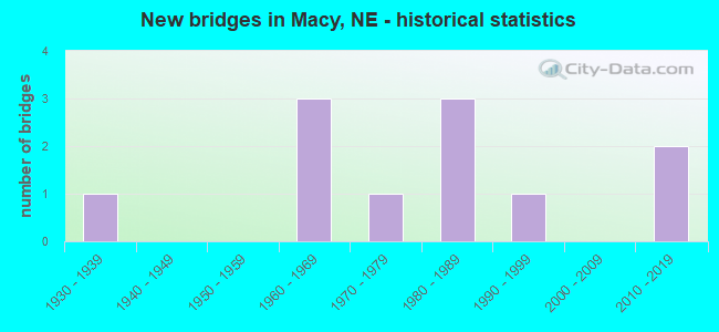
- New bridges - historical statistics
- 11930-1939
- 31960-1969
- 11970-1979
- 31980-1989
- 11990-1999
- 22010-2019

- Reconstructed bridges - Historical Statistics
- 11950-1959
- 01960-1969
- 01970-1979
- 01980-1989
- 01990-1999
- 12000-2009

- Bridge Condition - Deck
- 10.0%Very good
- 70.0%Good
- 10.0%Satisfactory
- 10.0%Fair

- Bridge Condition - Superstructure
- 20.0%Excellent
- 70.0%Good
- 10.0%Fair

- Bridge Condition - Substructure
- 10.0%Excellent
- 60.0%Good
- 20.0%Satisfactory
- 10.0%Fair

- Bridge Condition - Channel
- 27.3%Very good
- 18.2%Good
- 18.2%Satisfactory
- 27.3%Fair
- 9.1%Serious
Find on map >> Show street view
Structure Number: A048, Location: 5 KM EAST OF MACY (Lat: 42.109306, Lng: -96.317083), Route carried "on" structure: Federal lands road 501, Year Built: 1967, Status: Open, Structure Length: 3.32m (10.89ft), Average Daily Traffic: 28 (year 2020), Truck Traffic: 5%, Average Future Daily Traffic: 35 (year 2040), Design Load: H 15, Features Intersected: BLACKBIRD CREEK
Minimum Vertical Clearance: 30+ m (98+ ft), Kilometerpoint: 3.100, Lanes on structure: 2, Owner: Bureau of Indian Affairs, Approaching Roadway Width: 7.3m (24.0ft), Material/Design: Concrete, Design/Construction: Channel Beam, Number Of Spans In Main Unit: 3, Length of Maximum Span: 11.0m (36.1ft), Curb or Sidewalk Widths: Left: 0.2m (0.7ft), Right: 0.2m (0.7ft), Curb-To-Curb Width: 7.3m (24.0ft), Out-to-Out Width: 7.8m (25.6ft)
Condition: Deck: Fair, Superstructure: Fair, Substructure: Fair, Channel: Good, Operating Rating: 31.3 metric tons, Method Used To Determine Operating Rating: Allowable Stress (AS), Inventory Rating: 24.1 metric tons, Method Used To Determine Inventory Rating: Allowable Stress (AS), Structural Evaluation: Somewhat better than minimum adequacy, Deck Geometry: Equal to present minimum criteria, Waterway Adequacy: Meets minimum limits, Approach Roadway Alignment: Meets minimum limits, Bridge Posting: Required (Relationship of Operating Rating to Maximum Legal Load: 10.0 - 19.9% below), Designated Inspection Frequency: Every 24 months, Inspection Date: October 2020, Deck Structure Type: Concrete Precast Panels, Wearing Surface/Protective System: Wearing Surface: Bituminous
Find on map >> Show street view
Structure Number: A1, Location: SOUTH EDGE OF MACY (Lat: 42.108889, Lng: -96.356194), Route carried "on" structure: Federal lands road 50, Year Built: 1978, Status: Open, Structure Length: 4.57m (14.99ft), Average Daily Traffic: 108 (year 2020), Truck Traffic: 10%, Average Future Daily Traffic: 137 (year 2040), Design Load: HS 20+Mod, Features Intersected: NORTH BLACKBIRD CREEK
Minimum Vertical Clearance: 30+ m (98+ ft), Kilometerpoint: 3.700, Lanes on structure: 2, Owner: Bureau of Indian Affairs, Approaching Roadway Width: 8.0m (26.2ft), Material/Design: Prestressed concrete, Design/Construction: Stringer/Multi-beam, Number Of Spans In Main Unit: 3, Length of Maximum Span: 20.7m (67.9ft), Curb or Sidewalk Widths: Left: 0.4m (1.3ft), Right: 0.4m (1.3ft), Curb-To-Curb Width: 9.8m (32.2ft), Out-to-Out Width: 10.5m (34.4ft)
Condition: Deck: Good, Superstructure: Good, Substructure: Good, Channel: Fair, Operating Rating: 49.5 metric tons, Method Used To Determine Operating Rating: Allowable Stress (AS), Inventory Rating: 37.6 metric tons, Method Used To Determine Inventory Rating: Allowable Stress (AS), Structural Evaluation: Better than present minimum criteria, Deck Geometry: Better than present minimum criteria, Waterway Adequacy: Better than present minimum criteria, Approach Roadway Alignment: Equal to present desirable criteria, Designated Inspection Frequency: Every 24 months, Inspection Date: October 2020, Deck Structure Type: Concrete Cast-file-Place, Wearing Surface/Protective System: Wearing Surface: Monolithic Concrete
Find on map >> Show street view
Structure Number: A106, Location: 4.8 KM WEST&SOUTH OF MACY (Lat: 42.099056, Lng: -96.375639), Route carried "on" structure: Federal lands road 1, Year Built: 1980, Status: Open, Structure Length: 4.57m (14.99ft), Average Daily Traffic: 215 (year 2020), Truck Traffic: 10%, Average Future Daily Traffic: 268 (year 2040), Design Load: HS 20+Mod, Features Intersected: FOX CREEK
Minimum Vertical Clearance: 30+ m (98+ ft), Kilometerpoint: 2.300, Lanes on structure: 2, Owner: Bureau of Indian Affairs, Approaching Roadway Width: 7.0m (23.0ft), Material/Design: Prestressed concrete, Design/Construction: Stringer/Multi-beam, Number Of Spans In Main Unit: 3, Length of Maximum Span: 20.7m (67.9ft), Curb or Sidewalk Widths: Left: 0.4m (1.3ft), Right: 0.4m (1.3ft), Curb-To-Curb Width: 9.8m (32.2ft), Out-to-Out Width: 10.6m (34.8ft)
Condition: Deck: Good, Superstructure: Good, Substructure: Good, Channel: Fair, Operating Rating: 52.4 metric tons, Method Used To Determine Operating Rating: Allowable Stress (AS), Inventory Rating: 40.6 metric tons, Method Used To Determine Inventory Rating: Allowable Stress (AS), Structural Evaluation: Better than present minimum criteria, Deck Geometry: Better than present minimum criteria, Waterway Adequacy: Better than present minimum criteria, Approach Roadway Alignment: Equal to present minimum criteria, Designated Inspection Frequency: Every 24 months, Inspection Date: October 2020, Deck Structure Type: Concrete Cast-file-Place, Wearing Surface/Protective System: Wearing Surface: Monolithic Concrete
Find on map >> Show street view
Structure Number: A107, Location: 3.6 KM SOUTHEAST OF MACY (Lat: 42.082353, Lng: -96.339219), Route carried "on" structure: Federal lands road 1, Year Built: 1981, Status: Open, Structure Length: 4.57m (14.99ft), Average Daily Traffic: 108 (year 2020), Truck Traffic: 10%, Average Future Daily Traffic: 134 (year 2040), Design Load: HS 20+Mod, Features Intersected: SOUTH BLACKBIRD CREEK
Minimum Vertical Clearance: 30+ m (98+ ft), Kilometerpoint: 7.600, Lanes on structure: 2, Owner: Bureau of Indian Affairs, Approaching Roadway Width: 8.0m (26.2ft), Material/Design: Prestressed concrete, Design/Construction: Stringer/Multi-beam, Number Of Spans In Main Unit: 3, Length of Maximum Span: 20.7m (67.9ft), Curb or Sidewalk Widths: Left: 0.4m (1.3ft), Right: 0.4m (1.3ft), Curb-To-Curb Width: 9.8m (32.2ft), Out-to-Out Width: 10.6m (34.8ft)
Condition: Deck: Good, Superstructure: Good, Substructure: Satisfactory, Channel: Satisfactory, Operating Rating: 52.5 metric tons, Method Used To Determine Operating Rating: Allowable Stress (AS), Inventory Rating: 40.6 metric tons, Method Used To Determine Inventory Rating: Allowable Stress (AS), Structural Evaluation: Equal to present minimum criteria, Deck Geometry: Better than present minimum criteria, Waterway Adequacy: Better than present minimum criteria, Approach Roadway Alignment: Equal to present desirable criteria, Designated Inspection Frequency: Every 24 months, Inspection Date: October 2020, Deck Structure Type: Concrete Cast-file-Place, Wearing Surface/Protective System: Wearing Surface: Monolithic Concrete
Find on map >> Show street view
Structure Number: A113, Location: 1.7 KM WEST OF MACY (Lat: 42.111528, Lng: -96.377056), Route carried "on" structure: Federal lands road 2, Year Built: 1983, Status: Open, Structure Length: 4.57m (14.99ft), Average Daily Traffic: 364 (year 2020), Truck Traffic: 9%, Average Future Daily Traffic: 454 (year 2040), Design Load: HS 20+Mod, Features Intersected: NORTH BLACKBIRD CREEK
Minimum Vertical Clearance: 30+ m (98+ ft), Kilometerpoint: 6.900, Lanes on structure: 2, Owner: Bureau of Indian Affairs, Approaching Roadway Width: 7.0m (23.0ft), Skew: 4 degrees, Material/Design: Prestressed concrete, Design/Construction: Stringer/Multi-beam, Number Of Spans In Main Unit: 3, Length of Maximum Span: 21.3m (69.9ft), Curb or Sidewalk Widths: Left: 0.4m (1.3ft), Right: 0.4m (1.3ft), Curb-To-Curb Width: 9.8m (32.2ft), Out-to-Out Width: 10.6m (34.8ft)
Condition: Deck: Good, Superstructure: Good, Substructure: Good, Channel: Satisfactory, Operating Rating: 54.4 metric tons, Method Used To Determine Operating Rating: Allowable Stress (AS), Inventory Rating: 42.6 metric tons, Method Used To Determine Inventory Rating: Allowable Stress (AS), Structural Evaluation: Better than present minimum criteria, Deck Geometry: Better than present minimum criteria, Waterway Adequacy: Better than present minimum criteria, Approach Roadway Alignment: Equal to present desirable criteria, Designated Inspection Frequency: Every 24 months, Inspection Date: October 2020, Deck Structure Type: Concrete Cast-file-Place, Wearing Surface/Protective System: Wearing Surface: Monolithic Concrete
Find on map >> Show street view
Structure Number: A126, Location: 5 KM NORTHWEST OF MACY (Lat: 42.138250, Lng: -96.395417), Route carried "on" structure: Federal lands road 2, Year Built: 1993, Status: Open, Structure Length: 4.72m (15.49ft), Average Daily Traffic: 158 (year 2020), Truck Traffic: 10%, Average Future Daily Traffic: 191 (year 2040), Design Load: HS 20, Features Intersected: NORTH BLACKBIRD CREEK
Minimum Vertical Clearance: 30+ m (98+ ft), Kilometerpoint: 1.000, Lanes on structure: 2, Owner: Bureau of Indian Affairs, Approaching Roadway Width: 9.0m (29.5ft), Skew: 4 degrees, Material/Design: Prestressed concrete, Design/Construction: Stringer/Multi-beam, Number Of Spans In Main Unit: 3, Length of Maximum Span: 21.3m (69.9ft), Curb-To-Curb Width: 9.8m (32.2ft), Out-to-Out Width: 10.4m (34.1ft)
Condition: Deck: Satisfactory, Superstructure: Good, Substructure: Good, Channel: Good, Operating Rating: 43.5 metric tons, Method Used To Determine Operating Rating: Allowable Stress (AS), Inventory Rating: 32.7 metric tons, Method Used To Determine Inventory Rating: Allowable Stress (AS), Structural Evaluation: Better than present minimum criteria, Deck Geometry: Better than present minimum criteria, Waterway Adequacy: Better than present minimum criteria, Approach Roadway Alignment: Equal to present desirable criteria, Designated Inspection Frequency: Every 24 months, Inspection Date: October 2020, Deck Structure Type: Concrete Cast-file-Place, Wearing Surface/Protective System: Wearing Surface: Monolithic Concrete
Find on map >> Show street view
Structure Number: C00871321, Location: JCT US77/S-87B 6E (Lat: 42.060500, Lng: -96.346600), Route carried "on" structure: County highway 3920, Year Built: 1964, Status: Open, Structure Length: 4.60m (15.09ft), Average Daily Traffic: 40 (year 2011), Average Future Daily Traffic: 40 (year 2033), Features Intersected: SOUTH BLACKBIRD CREEK
Minimum Vertical Clearance: 30+ m (98+ ft), Kilometerpoint: 1.899, Lanes on structure: 2, Owner: County Highway Agency, Approaching Roadway Width: 6.4m (21.0ft), Material/Design: Steel continuous, Design/Construction: Stringer/Multi-beam, Number Of Spans In Main Unit: 3, Length of Maximum Span: 18.3m (60.0ft), Curb or Sidewalk Widths: Left: 0.3m (1.0ft), Right: 0.3m (1.0ft), Curb-To-Curb Width: 6.7m (22.0ft), Out-to-Out Width: 7.3m (24.0ft)
Condition: Deck: Good, Superstructure: Good, Substructure: Good, Channel: Very good, Operating Rating: 37.0 metric tons, Method Used To Determine Operating Rating: Load Factor (LF), Inventory Rating: 22.0 metric tons, Method Used To Determine Inventory Rating: Load Factor (LF), Structural Evaluation: Equal to present minimum criteria, Deck Geometry: Somewhat better than minimum adequacy, Waterway Adequacy: Equal to present desirable criteria, Approach Roadway Alignment: Equal to present desirable criteria, Designated Inspection Frequency: Every 24 months, Inspection Date: November 2020, Deck Structure Type: Concrete Cast-file-Place, Wearing Surface/Protective System: Wearing Surface: Monolithic Concrete
Find on map >> Show street view
Structure Number: S075 1573, Location: 8N DECATUR (Lat: 42.104900, Lng: -96.337900), Route carried "on" structure: US 75, Year Built: 2010, Status: Open, Structure Length: 5.64m (18.50ft), Average Daily Traffic: 1,380 (year 2018), Truck Traffic: 13%, Average Future Daily Traffic: 1,863 (year 2038), Design Load: HL 93, Features Intersected: SOUTH BLACKBIRD CREEK
Minimum Vertical Clearance: 30+ m (98+ ft), Kilometerpoint: 25.315, Lanes on structure: 2, Base Highway Network: Yes, Owner: State Highway Agency, Approaching Roadway Width: 12.2m (40.0ft), Material/Design: Steel continuous, Design/Construction: Stringer/Multi-beam, Number Of Spans In Main Unit: 3, Length of Maximum Span: 22.3m (73.2ft), Curb or Sidewalk Widths: Left: 0.2m (0.7ft), Right: 0.2m (0.7ft), Curb-To-Curb Width: 12.2m (40.0ft), Out-to-Out Width: 13.0m (42.7ft)
Condition: Deck: Good, Superstructure: Excellent, Substructure: Good, Channel: Very good, Operating Rating: 20.0 metric tons, Method Used To Determine Operating Rating: Load and Resistance Factor (LRFR), Inventory Rating: 15.0 metric tons, Method Used To Determine Inventory Rating: Load and Resistance Factor (LRFR), Structural Evaluation: Meets minimum limits, Deck Geometry: Better than present minimum criteria, Waterway Adequacy: Superior to present desirable criteria, Approach Roadway Alignment: Equal to present desirable criteria, Bridge Posting: Required (Relationship of Operating Rating to Maximum Legal Load: 30.0 - 39.9% below), Designated Inspection Frequency: Every 48 months, Inspection Date: September 2020, Deck Structure Type: Concrete Cast-file-Place, Wearing Surface/Protective System: Wearing Surface: Monolithic Concrete, Deck Protection: Epoxy Coated Reinforcing
Find on map >> Show street view
Structure Number: S075 15781, Location: 8N DECATUR (Lat: 42.110200, Lng: -96.344700), Route carried "on" structure: US 75, Year Built: 2010, Status: Open, Structure Length: 5.06m (16.60ft), Average Daily Traffic: 1,380 (year 2018), Truck Traffic: 13%, Average Future Daily Traffic: 1,863 (year 2038), Design Load: HL 93, Features Intersected: NORTH BLACKBIRD CREEK
Minimum Vertical Clearance: 30+ m (98+ ft), Kilometerpoint: 25.397, Lanes on structure: 2, Base Highway Network: Yes, Owner: State Highway Agency, Approaching Roadway Width: 12.2m (40.0ft), Material/Design: Steel continuous, Design/Construction: Stringer/Multi-beam, Number Of Spans In Main Unit: 3, Length of Maximum Span: 20.1m (65.9ft), Curb or Sidewalk Widths: Left: 0.3m (1.0ft), Right: 0.3m (1.0ft), Curb-To-Curb Width: 12.2m (40.0ft), Out-to-Out Width: 13.0m (42.7ft)
Condition: Deck: Good, Superstructure: Excellent, Substructure: Excellent, Channel: Very good, Operating Rating: 44.0 metric tons, Method Used To Determine Operating Rating: Load and Resistance Factor (LRFR), Inventory Rating: 34.0 metric tons, Method Used To Determine Inventory Rating: Load and Resistance Factor (LRFR), Structural Evaluation: Superior to present desirable criteria, Deck Geometry: Better than present minimum criteria, Waterway Adequacy: Superior to present desirable criteria, Approach Roadway Alignment: Equal to present desirable criteria, Length Of Structure Improvement: 3.23m (10.60ft), Designated Inspection Frequency: Every 48 months, Inspection Date: September 2020, Deck Structure Type: Concrete Cast-file-Place, Wearing Surface/Protective System: Wearing Surface: Monolithic Concrete, Deck Protection: Epoxy Coated Reinforcing
Find on map >> Show street view
Structure Number: S075 16302, Location: 13N DECATUR (Lat: 42.170100, Lng: -96.397500), Route carried "on" structure: US 75, Year Built: 1933, Year Reconstructed: 1950, Status: Open, Structure Length: 1.16m (3.81ft), Average Daily Traffic: 1,435 (year 2018), Truck Traffic: 12%, Average Future Daily Traffic: 2,224 (year 2038), Design Load: H 20, Features Intersected: NORTH BLACKBIRD CREEK
Minimum Vertical Clearance: 30+ m (98+ ft), Kilometerpoint: 26.235, Lanes on structure: 2, Base Highway Network: Yes, Owner: State Highway Agency, Approaching Roadway Width: 7.3m (24.0ft), Material/Design: Concrete, Design/Construction: Culvert, Number Of Spans In Main Unit: 3, Length of Maximum Span: 3.7m (12.1ft)
Condition: Channel: Fair, Culverts: Fair, Operating Rating: 33.0 metric tons, Method Used To Determine Operating Rating: Field evaluation and documented engineering judgment, Inventory Rating: 22.0 metric tons, Method Used To Determine Inventory Rating: Field evaluation and documented engineering judgment, Structural Evaluation: Somewhat better than minimum adequacy, Waterway Adequacy: Equal to present minimum criteria, Approach Roadway Alignment: Equal to present desirable criteria, Designated Inspection Frequency: Every 24 months, Inspection Date: September 2020
Find on map >> Show street view
Structure Number: S094 01745, Location: 4E WALTHILL (Lat: 42.147900, Lng: -96.397000), Route carried "on" structure: State highway 94, Year Built: 1964, Year Reconstructed: 2014, Status: Open, Structure Length: 5.21m (17.09ft), Average Daily Traffic: 1,340 (year 2018), Truck Traffic: 6%, Average Future Daily Traffic: 1,943 (year 2038), Design Load: H 20, Features Intersected: NORTH BLACKBIRD CREEK
Minimum Vertical Clearance: 30+ m (98+ ft), Kilometerpoint: 2.808, Lanes on structure: 2, Owner: State Highway Agency, Approaching Roadway Width: 9.1m (29.9ft), Material/Design: Steel continuous, Design/Construction: Stringer/Multi-beam, Number Of Spans In Main Unit: 3, Length of Maximum Span: 21.3m (69.9ft), Curb or Sidewalk Widths: Left: 0.4m (1.3ft), Right: 0.4m (1.3ft), Curb-To-Curb Width: 9.1m (29.9ft), Out-to-Out Width: 9.9m (32.5ft)
Condition: Deck: Very good, Superstructure: Good, Substructure: Satisfactory, Channel: Serious, Operating Rating: 57.0 metric tons, Method Used To Determine Operating Rating: Load Factor (LF), Inventory Rating: 34.0 metric tons, Method Used To Determine Inventory Rating: Load Factor (LF), Structural Evaluation: Equal to present minimum criteria, Deck Geometry: Somewhat better than minimum adequacy, Waterway Adequacy: Equal to present desirable criteria, Approach Roadway Alignment: Equal to present desirable criteria, Length Of Structure Improvement: 5.21m (17.09ft), Designated Inspection Frequency: Every 24 months, Inspection Date: September 2020, Deck Structure Type: Concrete Cast-file-Place, Wearing Surface/Protective System: Wearing Surface: Monolithic Concrete, Deck Protection: Epoxy Coated Reinforcing