Bridge Statistics for Madison, Arkansas (AR)
Condition, Traffic, Stress, Structural Evaluation, Project Costs
- National Bridge Inventory (NBI) Statistics
- 20Number of bridges
- 551ft / 168mTotal length
- $1,713,000Total costs
- 208,541Total average daily traffic
- 81,845Total average daily truck traffic
- National Bridge Inventory (NBI) Registered Bridges for Madison
- No street view available for this location
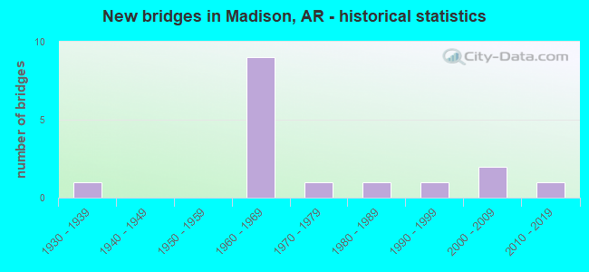
- New bridges - historical statistics
- 11930-1939
- 91960-1969
- 11970-1979
- 11980-1989
- 11990-1999
- 22000-2009
- 12010-2019


- Bridge Condition - Deck
- 7.7%Very good
- 61.5%Good
- 23.1%Satisfactory
- 7.7%Fair

- Bridge Condition - Superstructure
- 15.4%Very good
- 46.2%Good
- 30.8%Satisfactory
- 7.7%Poor

- Bridge Condition - Substructure
- 15.4%Very good
- 53.8%Good
- 23.1%Satisfactory
- 7.7%Fair

- Bridge Condition - Channel
- 7.7%Very good
- 23.1%Good
- 23.1%Satisfactory
- 46.2%Fair

- Bridge Condition - Culverts
- 66.7%Good
- 33.3%Satisfactory
Find on map >> Show street view
Structure Number: 1391, Location: 5.19 Miles East Of Sh 1 (Lat: 35.035511, Lng: -90.713081), Route carried "on" structure: US 70, Year Built: 1933, Status: Posted for load, Structure Length: 28.07m (92.09ft), Average Daily Traffic: 1,300 (year 2018), Truck Traffic: 18%, Average Future Daily Traffic: 1,210 (year 2028), Design Load: H 20, Features Intersected: St. Francis River
Minimum Vertical Clearance: 4.69m (15.39ft), Kilometerpoint: 8.352, Lanes on structure: 2, Owner: State Highway Agency, Approaching Roadway Width: 7.2m (23.6ft), Material/Design: Steel continuous, Design/Construction: Truss - Thru, Number Of Spans In Main Unit: 5, Number Of Approach Spans: 4, Length of Maximum Span: 71.0m (232.9ft), Curb or Sidewalk Widths: Left: 0.2m (0.7ft), Right: 0.2m (0.7ft), Curb-To-Curb Width: 7.3m (24.0ft), Out-to-Out Width: 7.6m (24.9ft)
Condition: Deck: Fair, Superstructure: Poor, Substructure: Satisfactory, Channel: Fair, Operating Rating: 31.8 metric tons, Method Used To Determine Operating Rating: Load Factor (LF), Inventory Rating: 19.1 metric tons, Method Used To Determine Inventory Rating: Load Factor (LF), Structural Evaluation: Meets minimum limits, Deck Geometry: Meets minimum limits, Waterway Adequacy: Equal to present desirable criteria, Approach Roadway Alignment: Better than present minimum criteria, Bridge Posting: Required (Relationship of Operating Rating to Maximum Legal Load: 20.0 - 29.9% below), Length Of Structure Improvement: 29.29m (96.10ft), Designated Inspection Frequency: Every 24 months, Critical Feature Inspection Frequency: Every 24 months, Inspection Date: May 2021, Critical Feature Inspection Date: May 2021, Roadway Improvement Cost: $125,000, Total Project Cost: $1,713,000, Deck Structure Type: Concrete Cast-file-Place, Wearing Surface/Protective System: Wearing Surface: Monolithic Concrete
Find on map >> Show street view
Structure Number: 3623, Location: West Of Sh 50 (Lat: 35.032414, Lng: -90.733542), Route carried "on" structure: County highway 430, Year Built: 1965, Status: Open, Structure Length: 6.89m (22.60ft), Average Daily Traffic: 234 (year 1987), Truck Traffic: 1%, Average Future Daily Traffic: 36 (year 2007), Design Load: HS 20, Features Intersected: I-40/Sec-51/L-244.0
Minimum Vertical Clearance: 30+ m (98+ ft), Kilometerpoint: 7.564, Lanes on structure: 2, Lanes under structure: 4, Owner: State Highway Agency, Approaching Roadway Width: 5.8m (19.0ft), Material/Design: Prestressed concrete, Design/Construction: Stringer/Multi-beam, Number Of Spans In Main Unit: 4, Length of Maximum Span: 20.1m (65.9ft), Curb or Sidewalk Widths: Left: 0.3m (1.0ft), Right: 0.3m (1.0ft), Curb-To-Curb Width: 6.1m (20.0ft), Out-to-Out Width: 7.5m (24.6ft)
Condition: Deck: Good, Superstructure: Good, Substructure: Good, Operating Rating: 54.4 metric tons, Method Used To Determine Operating Rating: Load Factor (LF), Inventory Rating: 32.7 metric tons, Method Used To Determine Inventory Rating: Load Factor (LF), Structural Evaluation: Better than present minimum criteria, Deck Geometry: Meets minimum limits, Underclear: High priority of corrective action, Approach Roadway Alignment: Equal to present desirable criteria, Designated Inspection Frequency: Every 24 months, Critical Feature Inspection Frequency: Every 24 months, Inspection Date: October 2020, Deck Structure Type: Concrete Cast-file-Place, Wearing Surface/Protective System: Wearing Surface: Monolithic Concrete
Find on map >> Show street view
Structure Number: 4226, Location: 1.2 M S Jct Cr 52 & Sh 50 (Lat: 34.999989, Lng: -90.716319), Route carried "on" structure: County highway 711, Year Built: 1966, Status: Open, Structure Length: 6.16m (20.21ft), Average Daily Traffic: 16 (year 2018), Truck Traffic: 1%, Average Future Daily Traffic: 172 (year 2007), Design Load: H 20, Features Intersected: Crow Creek
Minimum Vertical Clearance: 30+ m (98+ ft), Kilometerpoint: 20.246, Lanes on structure: 2, Owner: County Highway Agency, Approaching Roadway Width: 6.1m (20.0ft), Material/Design: Steel, Design/Construction: Stringer/Multi-beam, Number Of Spans In Main Unit: 4, Length of Maximum Span: 15.2m (49.9ft), Curb or Sidewalk Widths: Left: 0.5m (1.6ft), Right: 0.5m (1.6ft), Curb-To-Curb Width: 7.9m (25.9ft), Out-to-Out Width: 8.8m (28.9ft)
Condition: Deck: Satisfactory, Superstructure: Good, Substructure: Satisfactory, Channel: Fair, Operating Rating: 39.0 metric tons, Method Used To Determine Operating Rating: Load Factor (LF), Inventory Rating: 23.6 metric tons, Method Used To Determine Inventory Rating: Load Factor (LF), Structural Evaluation: Equal to present minimum criteria, Deck Geometry: Equal to present minimum criteria, Waterway Adequacy: Equal to present desirable criteria, Approach Roadway Alignment: Equal to present minimum criteria, Designated Inspection Frequency: Every 24 months, Critical Feature Inspection Frequency: Every 24 months, Inspection Date: March 2021, Deck Structure Type: Concrete Cast-file-Place, Wearing Surface/Protective System: Wearing Surface: Monolithic Concrete
Find on map >> Show street view
Structure Number: 4831, Location: .84 M South Cr 344 & SH50 (Lat: 35.003611, Lng: -90.733411), Route carried "on" structure: County highway 702, Year Built: 2001, Status: Open, Structure Length: 3.60m (11.81ft), Average Daily Traffic: 591 (year 2018), Truck Traffic: 10%, Average Future Daily Traffic: 133 (year 2020), Features Intersected: Crow Creek
Minimum Vertical Clearance: 30+ m (98+ ft), Kilometerpoint: 1.352, Lanes on structure: 2, Owner: County Highway Agency, Approaching Roadway Width: 7.3m (24.0ft), Material/Design: Steel continuous, Design/Construction: Stringer/Multi-beam, Number Of Spans In Main Unit: 3, Length of Maximum Span: 13.4m (44.0ft), Curb-To-Curb Width: 7.3m (24.0ft), Out-to-Out Width: 8.3m (27.2ft)
Condition: Deck: Good, Superstructure: Good, Substructure: Very good, Channel: Satisfactory, Operating Rating: 54.4 metric tons, Method Used To Determine Operating Rating: Load Factor (LF), Inventory Rating: 32.7 metric tons, Method Used To Determine Inventory Rating: Load Factor (LF), Structural Evaluation: Better than present minimum criteria, Deck Geometry: Meets minimum limits, Waterway Adequacy: Better than present minimum criteria, Approach Roadway Alignment: Equal to present minimum criteria, Designated Inspection Frequency: Every 24 months, Critical Feature Inspection Frequency: Every 24 months, Inspection Date: August 2021, Deck Structure Type: Concrete Cast-file-Place, Wearing Surface/Protective System: Wearing Surface: Monolithic Concrete, Deck Protection: Epoxy Coated Reinforcing
Find on map >> Show street view
Structure Number: 5491, Location: 0.2 Miles East Of Madison (Lat: 35.013158, Lng: -90.719989), Route carried "on" structure: State highway 50, Year Built: 1975, Status: Open, Structure Length: 22.31m (73.20ft), Average Daily Traffic: 570 (year 2018), Truck Traffic: 1%, Average Future Daily Traffic: 980 (year 2028), Design Load: HS 20, Features Intersected: St. Francis River
Minimum Vertical Clearance: 30+ m (98+ ft), Kilometerpoint: 0.885, Lanes on structure: 2, Owner: State Highway Agency, Approaching Roadway Width: 7.6m (24.9ft), Material/Design: Steel continuous, Design/Construction: Stringer/Multi-beam, Number Of Spans In Main Unit: 4, Number Of Approach Spans: 4, Length of Maximum Span: 34.1m (111.9ft), Curb-To-Curb Width: 9.1m (29.9ft), Out-to-Out Width: 9.9m (32.5ft)
Condition: Deck: Good, Superstructure: Satisfactory, Substructure: Satisfactory, Channel: Satisfactory, Operating Rating: 54.4 metric tons, Method Used To Determine Operating Rating: Load Factor (LF), Inventory Rating: 32.7 metric tons, Method Used To Determine Inventory Rating: Load Factor (LF), Structural Evaluation: Equal to present minimum criteria, Deck Geometry: Equal to present minimum criteria, Waterway Adequacy: Equal to present desirable criteria, Approach Roadway Alignment: Equal to present desirable criteria, Designated Inspection Frequency: Every 24 months, Critical Feature Inspection Frequency: Every 24 months, Inspection Date: August 2020, Deck Structure Type: Concrete Cast-file-Place, Wearing Surface/Protective System: Wearing Surface: Monolithic Concrete
Find on map >> Show street view
Structure Number: 6622, Location: 2.90 Mi East Of Jct Sh 1 (Lat: 35.011631, Lng: -90.737800), Route carried "on" structure: US 70, Year Built: 1999, Status: Open, Structure Length: 7.17m (23.52ft), Average Daily Traffic: 3,100 (year 2019), Truck Traffic: 18%, Average Future Daily Traffic: 3,872 (year 2028), Design Load: H 10, Features Intersected: Crow Creek
Minimum Vertical Clearance: 30+ m (98+ ft), Kilometerpoint: 4.587, Lanes on structure: 2, Owner: State Highway Agency, Approaching Roadway Width: 12.0m (39.4ft), Material/Design: Steel continuous, Design/Construction: Stringer/Multi-beam, Number Of Spans In Main Unit: 3, Length of Maximum Span: 27.4m (89.9ft), Curb-To-Curb Width: 12.0m (39.4ft), Out-to-Out Width: 12.9m (42.3ft)
Condition: Deck: Good, Superstructure: Good, Substructure: Good, Channel: Good, Operating Rating: 54.4 metric tons, Method Used To Determine Operating Rating: Load Factor (LF), Inventory Rating: 32.7 metric tons, Method Used To Determine Inventory Rating: Load Factor (LF), Structural Evaluation: Better than present minimum criteria, Deck Geometry: Somewhat better than minimum adequacy, Waterway Adequacy: Equal to present desirable criteria, Approach Roadway Alignment: Better than present minimum criteria, Designated Inspection Frequency: Every 24 months, Critical Feature Inspection Frequency: Every 24 months, Inspection Date: April 2021, Deck Structure Type: Concrete Cast-file-Place, Wearing Surface/Protective System: Wearing Surface: Monolithic Concrete, Deck Protection: Epoxy Coated Reinforcing
Find on map >> Show street view
Structure Number: 20731, Location: 3.08 Mi East Cr 52 & Us70 (Lat: 35.000728, Lng: -90.732472), Route carried "on" structure: County highway 735, Year Built: 1988, Status: Open, Structure Length: 2.29m (7.51ft), Average Daily Traffic: 108 (year 2018), Truck Traffic: 1%, Average Future Daily Traffic: 237 (year 2007), Features Intersected: Branch Of Crow Creek
Minimum Vertical Clearance: 30+ m (98+ ft), Kilometerpoint: 4.748, Lanes on structure: 2, Owner: County Highway Agency, Approaching Roadway Width: 6.7m (22.0ft), Material/Design: Concrete, Design/Construction: Channel Beam, Number Of Spans In Main Unit: 3, Length of Maximum Span: 7.6m (24.9ft), Curb or Sidewalk Widths: Left: 0.2m (0.7ft), Right: 0.2m (0.7ft), Curb-To-Curb Width: 6.3m (20.7ft), Out-to-Out Width: 6.6m (21.7ft)
Condition: Deck: Good, Superstructure: Satisfactory, Substructure: Good, Channel: Fair, Operating Rating: 54.4 metric tons, Method Used To Determine Operating Rating: Load Factor (LF), Inventory Rating: 32.7 metric tons, Method Used To Determine Inventory Rating: Load Factor (LF), Structural Evaluation: Equal to present minimum criteria, Deck Geometry: Meets minimum limits, Waterway Adequacy: Equal to present desirable criteria, Approach Roadway Alignment: Equal to present minimum criteria, Designated Inspection Frequency: Every 24 months, Critical Feature Inspection Frequency: Every 24 months, Inspection Date: March 2021, Deck Structure Type: Concrete Precast Panels, Wearing Surface/Protective System: Wearing Surface: Monolithic Concrete
Find on map >> Show street view
Structure Number: 22761, Location: 0.6 Miles North Of 52 &33 (Lat: 34.958331, Lng: -90.693542), Route carried "on" structure: County highway 711, Year Built: 2009, Status: Open, Structure Length: 0.69m (2.26ft), Average Daily Traffic: 16 (year 2018), Truck Traffic: 1%, Average Future Daily Traffic: 172 (year 2007), Features Intersected: Pond Slough
Minimum Vertical Clearance: 30+ m (98+ ft), Kilometerpoint: 14.114, Lanes on structure: 2, Owner: County Highway Agency, Approaching Roadway Width: 6.1m (20.0ft), Material/Design: Steel, Design/Construction: Culvert, Number Of Spans In Main Unit: 2, Length of Maximum Span: 2.8m (9.2ft)
Condition: Channel: Good, Culverts: Good, Operating Rating: 54.4 metric tons, Method Used To Determine Operating Rating: Load Factor (LF), Inventory Rating: 32.7 metric tons, Method Used To Determine Inventory Rating: Load Factor (LF), Structural Evaluation: Better than present minimum criteria, Waterway Adequacy: Better than present minimum criteria, Approach Roadway Alignment: Superior to present desirable criteria, Designated Inspection Frequency: Every 24 months, Critical Feature Inspection Frequency: Every 24 months, Inspection Date: March 2021, Wearing Surface/Protective System: Wearing Surface: Gravel
Find on map >> Show street view
Structure Number: 23587, Location: .25 Mi North Gore Rd&Us70 (Lat: 35.015703, Lng: -90.738469), Route carried "on" structure: City street 22975, Year Built: 2014, Status: Open, Structure Length: 0.69m (2.26ft), Average Daily Traffic: 406 (year 2018), Truck Traffic: 1%, Average Future Daily Traffic: 24 (year 2029), Features Intersected: Branch of Crow Creek, Facility Carried by Structure: Gore Road
Minimum Vertical Clearance: 30+ m (98+ ft), Kilometerpoint: 0.402, Lanes on structure: 1, Owner: City or Municipal Highway Agency, Approaching Roadway Width: 4.6m (15.1ft), Material/Design: Concrete, Design/Construction: Culvert, Number Of Spans In Main Unit: 2, Length of Maximum Span: 3.0m (9.8ft), Curb or Sidewalk Widths: Left: 0.3m (1.0ft), Right: 0.3m (1.0ft), Curb-To-Curb Width: 7.2m (23.6ft), Out-to-Out Width: 8.0m (26.2ft)
Condition: Channel: Satisfactory, Culverts: Good, Operating Rating: 30.8 metric tons, Method Used To Determine Operating Rating: Load Factor (LF), Inventory Rating: 18.1 metric tons, Method Used To Determine Inventory Rating: Load Factor (LF), Structural Evaluation: Somewhat better than minimum adequacy, Deck Geometry: Meets minimum limits, Waterway Adequacy: Equal to present desirable criteria, Approach Roadway Alignment: Equal to present desirable criteria, Designated Inspection Frequency: Every 24 months, Critical Feature Inspection Frequency: Every 24 months, Inspection Date: July 2020, Deck Structure Type: Concrete Precast Panels, Wearing Surface/Protective System: Wearing Surface: Monolithic Concrete
Find on map >> Show street view
Structure Number: A3621, Location: 2.3 Mi E Jct Sh 1 & I-40 (Lat: 35.035789, Lng: -90.750331), Route carried "on" structure: Interstate 40, Year Built: 1965, Year Reconstructed: 1988, Status: Open, Structure Length: 7.83m (25.69ft), Average Daily Traffic: 17,500 (year 2018), Truck Traffic: 1%, Average Future Daily Traffic: 20,570 (year 2028), Design Load: HS 20+Mod, Features Intersected: Crow Creek
Minimum Vertical Clearance: 30+ m (98+ ft), Kilometerpoint: 391.103, Lanes on structure: 2, Base Highway Network: Yes, Owner: State Highway Agency, Approaching Roadway Width: 12.2m (40.0ft), Material/Design: Steel, Design/Construction: Stringer/Multi-beam, Number Of Spans In Main Unit: 3, Length of Maximum Span: 25.9m (85.0ft), Curb-To-Curb Width: 12.2m (40.0ft), Out-to-Out Width: 13.1m (43.0ft)
Condition: Deck: Good, Superstructure: Very good, Substructure: Fair, Channel: Fair, Operating Rating: 54.4 metric tons, Method Used To Determine Operating Rating: Load Factor (LF), Inventory Rating: 32.7 metric tons, Method Used To Determine Inventory Rating: Load Factor (LF), Structural Evaluation: Somewhat better than minimum adequacy, Deck Geometry: Better than present minimum criteria, Waterway Adequacy: Equal to present desirable criteria, Approach Roadway Alignment: Equal to present desirable criteria, Designated Inspection Frequency: Every 24 months, Critical Feature Inspection Frequency: Every 24 months, Inspection Date: August 2020, Deck Structure Type: Concrete Cast-file-Place, Wearing Surface/Protective System: Wearing Surface: Monolithic Concrete
Find on map >> Show street view
Structure Number: A3624, Location: 2.3 Mi W Sh 38 & I-40 (Lat: 35.035031, Lng: -90.721550), Route carried "on" structure: Interstate 40, Year Built: 1965, Year Reconstructed: 1988, Status: Open, Structure Length: 5.21m (17.09ft), Average Daily Traffic: 17,500 (year 2018), Truck Traffic: 1%, Average Future Daily Traffic: 20,570 (year 2028), Design Load: HS 20+Mod, Features Intersected: Sh-50/Sec-0/L-0.91
Minimum Vertical Clearance: 30+ m (98+ ft), Kilometerpoint: 393.823, Lanes on structure: 2, Lanes under structure: 2, Base Highway Network: Yes, Owner: State Highway Agency, Approaching Roadway Width: 11.6m (38.1ft), Skew: 4 degrees, Material/Design: Prestressed concrete, Design/Construction: Stringer/Multi-beam, Number Of Spans In Main Unit: 3, Length of Maximum Span: 18.3m (60.0ft), Curb-To-Curb Width: 12.2m (40.0ft), Out-to-Out Width: 13.0m (42.7ft)
Condition: Deck: Satisfactory, Superstructure: Good, Substructure: Good, Operating Rating: 54.4 metric tons, Method Used To Determine Operating Rating: Load Factor (LF), Inventory Rating: 32.7 metric tons, Method Used To Determine Inventory Rating: Load Factor (LF), Structural Evaluation: Better than present minimum criteria, Deck Geometry: Better than present minimum criteria, Underclear: Meets minimum limits, Approach Roadway Alignment: Better than present minimum criteria, Designated Inspection Frequency: Every 24 months, Critical Feature Inspection Frequency: Every 24 months, Inspection Date: July 2020, Deck Structure Type: Concrete Cast-file-Place, Wearing Surface/Protective System: Wearing Surface: Monolithic Concrete
Find on map >> Show street view
Structure Number: A3625, Location: 1.9 Miles Sw Jct Sh 38 (Lat: 35.038978, Lng: -90.715733), Route carried "on" structure: Interstate 40, Year Built: 1965, Year Reconstructed: 1988, Status: Open, Structure Length: 31.30m (102.69ft), Average Daily Traffic: 34,000 (year 2019), Truck Traffic: 65%, Average Future Daily Traffic: 20,570 (year 2028), Design Load: HS 20+Mod, Features Intersected: St Francis River
Minimum Vertical Clearance: 30+ m (98+ ft), Kilometerpoint: 394.418, Lanes on structure: 2, Base Highway Network: Yes, Owner: State Highway Agency, Approaching Roadway Width: 12.2m (40.0ft), Material/Design: Steel, Design/Construction: Stringer/Multi-beam, Number Of Spans In Main Unit: 8, Number Of Approach Spans: 5, Length of Maximum Span: 38.1m (125.0ft), Curb-To-Curb Width: 12.2m (40.0ft), Out-to-Out Width: 13.1m (43.0ft)
Condition: Deck: Satisfactory, Superstructure: Satisfactory, Substructure: Good, Channel: Good, Operating Rating: 54.4 metric tons, Method Used To Determine Operating Rating: Load Factor (LF), Inventory Rating: 32.7 metric tons, Method Used To Determine Inventory Rating: Load Factor (LF), Structural Evaluation: Equal to present minimum criteria, Deck Geometry: Better than present minimum criteria, Waterway Adequacy: Equal to present desirable criteria, Approach Roadway Alignment: Equal to present desirable criteria, Designated Inspection Frequency: Every 24 months, Critical Feature Inspection Frequency: Every 24 months, Inspection Date: January 2021, Deck Structure Type: Concrete Cast-file-Place, Wearing Surface/Protective System: Wearing Surface: Monolithic Concrete
Find on map >> Show street view
Structure Number: B3621, Location: 1.25 Mi East Jct Sh 284 (Lat: 35.035569, Lng: -90.750411), Route carried "on" structure: Interstate 40, Year Built: 1965, Year Reconstructed: 1988, Status: Open, Structure Length: 7.83m (25.69ft), Average Daily Traffic: 17,500 (year 2018), Truck Traffic: 56%, Average Future Daily Traffic: 20,570 (year 2028), Design Load: HS 20+Mod, Features Intersected: Crow Creek
Minimum Vertical Clearance: 30+ m (98+ ft), Kilometerpoint: 391.103, Lanes on structure: 2, Base Highway Network: Yes, Owner: State Highway Agency, Approaching Roadway Width: 12.2m (40.0ft), Material/Design: Steel, Design/Construction: Stringer/Multi-beam, Number Of Spans In Main Unit: 3, Length of Maximum Span: 25.9m (85.0ft), Curb-To-Curb Width: 12.2m (40.0ft), Out-to-Out Width: 13.1m (43.0ft)
Condition: Deck: Good, Superstructure: Very good, Substructure: Very good, Channel: Fair, Operating Rating: 54.4 metric tons, Method Used To Determine Operating Rating: Load Factor (LF), Inventory Rating: 32.7 metric tons, Method Used To Determine Inventory Rating: Load Factor (LF), Structural Evaluation: Equal to present desirable criteria, Deck Geometry: Better than present minimum criteria, Waterway Adequacy: Equal to present desirable criteria, Approach Roadway Alignment: Equal to present desirable criteria, Designated Inspection Frequency: Every 24 months, Critical Feature Inspection Frequency: Every 24 months, Inspection Date: August 2020, Deck Structure Type: Concrete Cast-file-Place, Wearing Surface/Protective System: Wearing Surface: Monolithic Concrete
Find on map >> Show street view
Structure Number: B3624, Location: 2.3 Miles West Of Sh 38 (Lat: 35.034639, Lng: -90.721739), Route carried "on" structure: Interstate 40, Year Built: 1965, Year Reconstructed: 1988, Status: Open, Structure Length: 5.36m (17.59ft), Average Daily Traffic: 17,500 (year 2018), Truck Traffic: 56%, Average Future Daily Traffic: 20,570 (year 2028), Design Load: HS 20+Mod, Features Intersected: Sh-50/Sec-0/L-0.92
Minimum Vertical Clearance: 30+ m (98+ ft), Kilometerpoint: 393.855, Lanes on structure: 2, Lanes under structure: 2, Base Highway Network: Yes, Owner: State Highway Agency, Approaching Roadway Width: 11.6m (38.1ft), Skew: 4 degrees, Material/Design: Prestressed concrete, Design/Construction: Stringer/Multi-beam, Number Of Spans In Main Unit: 3, Length of Maximum Span: 19.8m (65.0ft), Curb-To-Curb Width: 12.2m (40.0ft), Out-to-Out Width: 13.0m (42.7ft)
Condition: Deck: Very good, Superstructure: Good, Substructure: Good, Operating Rating: 54.4 metric tons, Method Used To Determine Operating Rating: Load Factor (LF), Inventory Rating: 32.7 metric tons, Method Used To Determine Inventory Rating: Load Factor (LF), Structural Evaluation: Better than present minimum criteria, Deck Geometry: Better than present minimum criteria, Underclear: Meets minimum limits, Approach Roadway Alignment: Better than present minimum criteria, Designated Inspection Frequency: Every 24 months, Critical Feature Inspection Frequency: Every 24 months, Inspection Date: July 2020, Deck Structure Type: Concrete Cast-file-Place, Wearing Surface/Protective System: Wearing Surface: Monolithic Concrete
Find on map >> Show street view
Structure Number: B3625, Location: 1.9 Miles Sw Of Jct Sh 38 (Lat: 35.038808, Lng: -90.715558), Route carried "on" structure: Interstate 40, Year Built: 1965, Year Reconstructed: 1988, Status: Open, Structure Length: 31.30m (102.69ft), Average Daily Traffic: 34,000 (year 2019), Truck Traffic: 56%, Average Future Daily Traffic: 20,570 (year 2028), Design Load: HS 20+Mod, Features Intersected: St Francis River
Minimum Vertical Clearance: 30+ m (98+ ft), Kilometerpoint: 394.418, Lanes on structure: 2, Base Highway Network: Yes, Owner: State Highway Agency, Approaching Roadway Width: 12.2m (40.0ft), Material/Design: Steel, Design/Construction: Stringer/Multi-beam, Number Of Spans In Main Unit: 8, Number Of Approach Spans: 5, Length of Maximum Span: 38.1m (125.0ft), Curb-To-Curb Width: 12.2m (40.0ft), Out-to-Out Width: 13.1m (43.0ft)
Condition: Deck: Good, Superstructure: Satisfactory, Substructure: Good, Channel: Very good, Operating Rating: 54.4 metric tons, Method Used To Determine Operating Rating: Load Factor (LF), Inventory Rating: 32.7 metric tons, Method Used To Determine Inventory Rating: Load Factor (LF), Structural Evaluation: Equal to present minimum criteria, Deck Geometry: Better than present minimum criteria, Waterway Adequacy: Equal to present desirable criteria, Approach Roadway Alignment: Equal to present desirable criteria, Designated Inspection Frequency: Every 24 months, Critical Feature Inspection Frequency: Every 24 months, Inspection Date: January 2021, Deck Structure Type: Concrete Cast-file-Place, Wearing Surface/Protective System: Wearing Surface: Monolithic Concrete
Find on map >> Show street view
Structure Number: M3045, Location: 1.3 Mi E Jct Sh 1 & I-40 (Lat: 35.034581, Lng: -90.745622), Route carried "on" structure: Interstate 40, Year Built: 1965, Status: Open, Structure Length: 0.82m (2.69ft), Average Daily Traffic: 35,000 (year 2018), Truck Traffic: 56%, Average Future Daily Traffic: 41,141 (year 2028), Features Intersected: Drainage Ditch
Minimum Vertical Clearance: 30+ m (98+ ft), Kilometerpoint: 391.570, Lanes on structure: 4, Base Highway Network: Yes, Owner: State Highway Agency, Approaching Roadway Width: 23.2m (76.1ft), Skew: 1 degrees, Material/Design: Concrete, Design/Construction: Culvert, Number Of Spans In Main Unit: 2, Length of Maximum Span: 4.0m (13.1ft)
Condition: Channel: Fair, Culverts: Satisfactory, Operating Rating: 39.9 metric tons, Method Used To Determine Operating Rating: Load Factor (LF), Inventory Rating: 23.6 metric tons, Method Used To Determine Inventory Rating: Load Factor (LF), Structural Evaluation: Somewhat better than minimum adequacy, Waterway Adequacy: Equal to present desirable criteria, Approach Roadway Alignment: Equal to present desirable criteria, Designated Inspection Frequency: Every 24 months, Critical Feature Inspection Frequency: Every 24 months, Inspection Date: July 2020
Find on map >> Show street view
Structure Number: 3623, Location: West Of Sh 50 (Lat: 35.032414, Lng: -90.733542), Route carried "under" structure: Interstate 40, Structure Length: 0. m, Average Daily Traffic: 14,500 (year 2013), Truck Traffic: 1%, Features Intersected: I-40/Sec-51/L-244.0, Facility Carried by Structure: Cr-430/Z-E/L-4.7
Minimum Vertical Clearance: 5.25m (17.22ft), Kilometerpoint: 392.680, Length of Maximum Span: 0.0m
Find on map >> Show street view
Structure Number: 3623, Location: West Of Sh 50 (Lat: 35.032414, Lng: -90.733542), Route carried "under" structure: Interstate 40, Structure Length: 0. m, Average Daily Traffic: 14,500 (year 2013), Truck Traffic: 1%, Features Intersected: I-40/Sec-51/L-244.0, Facility Carried by Structure: Cr-430/Z-E/L-4.7
Minimum Vertical Clearance: 5.03m (16.50ft), Kilometerpoint: 392.680, Length of Maximum Span: 0.0m
Find on map >> Show street view
Structure Number: A3624, Location: 2.3 Mi W Sh 38 & I-40 (Lat: 35.035031, Lng: -90.721550), Route carried "under" structure: State highway 50, Structure Length: 0. m, Average Daily Traffic: 100 (year 2014), Truck Traffic: 1%, Features Intersected: Sh-50/Sec-0/L-0.91, Facility Carried by Structure: I-40WB/Se51/244.71
Minimum Vertical Clearance: 4.47m (14.67ft), Kilometerpoint: 1.465, Length of Maximum Span: 0.0m
Find on map >> Show street view
Structure Number: B3624, Location: 2.3 Miles West Of Sh 38 (Lat: 35.034639, Lng: -90.721739), Route carried "under" structure: State highway 50, Structure Length: 0. m, Average Daily Traffic: 100 (year 2014), Truck Traffic: 1%, Features Intersected: Sh-50/Sec-0/L-0.92, Facility Carried by Structure: I-40EB/Se51/244.73
Minimum Vertical Clearance: 5.34m (17.52ft), Kilometerpoint: 1.481, Length of Maximum Span: 0.0m