Bridge Statistics for Magnolia, Texas (TX)
Condition, Traffic, Stress, Structural Evaluation, Project Costs
- National Bridge Inventory (NBI) Statistics
- 15Number of bridges
- 351ft / 107mTotal length
- 98,260Total average daily traffic
- 6,476Total average daily truck traffic
- National Bridge Inventory (NBI) Registered Bridges for Magnolia
- No street view available for this location
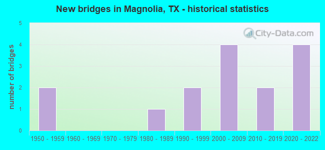
- New bridges - historical statistics
- 21950-1959
- 11980-1989
- 21990-1999
- 42000-2009
- 22010-2019
- 42020-2022

- Reconstructed bridges - Historical Statistics
- 11990-1999
- 12000-2009


- Bridge Condition - Deck
- 80.0%Very good
- 20.0%Good

- Bridge Condition - Substructure
- 40.0%Very good
- 40.0%Good
- 20.0%Satisfactory

- Bridge Condition - Channel
- 9.1%Very good
- 54.5%Good
- 27.3%Satisfactory
- 9.1%Fair

- Bridge Condition - Culverts
- 75.0%Good
- 12.5%Satisfactory
- 12.5%Fair
Find on map >> Show street view
Structure Number: 121700052308013, Location: 1.75 MI SW OF FM 1774 (Lat: 30.197119, Lng: -95.777825), Route carried "on" structure: State highway 1488, Year Built: 1955, Year Reconstructed: 1990, Status: Open, Structure Length: 0.98m (3.22ft), Average Daily Traffic: 9,663 (year 2020), Truck Traffic: 9%, Average Future Daily Traffic: 11,450 (year 2033), Features Intersected: MINK BRANCH
Minimum Vertical Clearance: 30+ m (98+ ft), Kilometerpoint: 2.823, Lanes on structure: 2, Owner: State Highway Agency, Approaching Roadway Width: 12.2m (40.0ft), Material/Design: Concrete, Design/Construction: Culvert, Number Of Spans In Main Unit: 5, Length of Maximum Span: 1.8m (5.9ft)
Condition: Channel: Fair, Culverts: Fair, Operating Rating: 39.9 metric tons, Method Used To Determine Operating Rating: Load Factor (LF), Inventory Rating: 23.6 metric tons, Method Used To Determine Inventory Rating: Load Factor (LF), Structural Evaluation: Somewhat better than minimum adequacy, Waterway Adequacy: Equal to present minimum criteria, Approach Roadway Alignment: Equal to present desirable criteria, Designated Inspection Frequency: Every 24 months, Inspection Date: August 2020
Find on map >> Show street view
Structure Number: 121700052308025, Location: 3.40 MI SW OF FM 1774 (Lat: 30.189464, Lng: -95.803583), Route carried "on" structure: State highway 1488, Year Built: 1989, Status: Open, Structure Length: 0.70m (2.30ft), Average Daily Traffic: 6,283 (year 2020), Truck Traffic: 9%, Average Future Daily Traffic: 11,450 (year 2033), Design Load: HS 20, Features Intersected: LOG GULLY
Minimum Vertical Clearance: 30+ m (98+ ft), Kilometerpoint: 0.240, Lanes on structure: 3, Owner: State Highway Agency, Approaching Roadway Width: 12.2m (40.0ft), Material/Design: Concrete, Design/Construction: Culvert, Number Of Spans In Main Unit: 2, Length of Maximum Span: 3.0m (9.8ft)
Condition: Channel: Good, Culverts: Good, Operating Rating: 39.9 metric tons, Method Used To Determine Operating Rating: Load Factor (LF), Inventory Rating: 23.6 metric tons, Method Used To Determine Inventory Rating: Load Factor (LF), Structural Evaluation: Somewhat better than minimum adequacy, Waterway Adequacy: Equal to present minimum criteria, Approach Roadway Alignment: Equal to present desirable criteria, Designated Inspection Frequency: Every 48 months, Inspection Date: September 2020
Find on map >> Show street view
Structure Number: 12170014000402, Location: 0.5 MI W OF FM 1488 (Lat: 30.213925, Lng: -95.760800), Route carried "on" structure: State highway 1774, Year Built: 2020, Status: Open, Structure Length: 46.36m (152.10ft), Average Daily Traffic: 12,865 (year 2019), Truck Traffic: 6%, Average Future Daily Traffic: 15,439 (year 2039), Design Load: HL 93, Features Intersected: UPRR
Minimum Vertical Clearance: 30+ m (98+ ft), Kilometerpoint: 0.000, Lanes on structure: 2, Lanes under structure: 1, Owner: State Highway Agency, Approaching Roadway Width: 9.1m (29.9ft), Material/Design: Steel continuous, Design/Construction: Stringer/Multi-beam, Number Of Spans In Main Unit: 3, Number Of Approach Spans: 10, Length of Maximum Span: 79.2m (259.8ft), Curb-To-Curb Width: 9.4m (30.8ft), Out-to-Out Width: 10.2m (33.5ft)
Condition: Deck: Very good, Superstructure: Very good, Substructure: Very good, Operating Rating: 54.4 metric tons, Method Used To Determine Operating Rating: Assigned ratings based on Load and Resistance Factor Design (LRFD) reported in metric tons, Inventory Rating: 32.7 metric tons, Method Used To Determine Inventory Rating: Assigned ratings based on Load and Resistance Factor Design (LRFD) reported in metric tons, Structural Evaluation: Equal to present desirable criteria, Deck Geometry: Meets minimum limits, Underclear: Meets minimum limits, Approach Roadway Alignment: Equal to present desirable criteria, Designated Inspection Frequency: Every 24 months, Inspection Date: December 2020, Deck Structure Type: Concrete Cast-file-Place
Find on map >> Show street view
Structure Number: 121700140004021, Location: 0.5 MI W OF FM 1488 (Lat: 30.213972, Lng: -95.761028), Route carried "on" structure: State highway 1774, Year Built: 2020, Status: Open, Structure Length: 46.36m (152.10ft), Average Daily Traffic: 12,865 (year 2019), Truck Traffic: 6%, Average Future Daily Traffic: 15,439 (year 2039), Design Load: HL 93, Features Intersected: UPRR
Minimum Vertical Clearance: 30+ m (98+ ft), Kilometerpoint: 0.000, Lanes on structure: 2, Lanes under structure: 1, Owner: State Highway Agency, Approaching Roadway Width: 9.1m (29.9ft), Material/Design: Steel continuous, Design/Construction: Stringer/Multi-beam, Number Of Spans In Main Unit: 3, Number Of Approach Spans: 9, Length of Maximum Span: 79.2m (259.8ft), Curb-To-Curb Width: 9.4m (30.8ft), Out-to-Out Width: 10.2m (33.5ft)
Condition: Deck: Very good, Superstructure: Very good, Substructure: Very good, Operating Rating: 54.4 metric tons, Method Used To Determine Operating Rating: Assigned ratings based on Load and Resistance Factor Design (LRFD) reported in metric tons, Inventory Rating: 32.7 metric tons, Method Used To Determine Inventory Rating: Assigned ratings based on Load and Resistance Factor Design (LRFD) reported in metric tons, Structural Evaluation: Equal to present desirable criteria, Deck Geometry: Meets minimum limits, Underclear: Meets minimum limits, Approach Roadway Alignment: Equal to present desirable criteria, Designated Inspection Frequency: Every 24 months, Inspection Date: December 2020, Deck Structure Type: Concrete Cast-file-Place
Find on map >> Show street view
Structure Number: 121700140004022, Location: 0.86 MI SE OF FM 1488 (Lat: 30.204597, Lng: -95.742033), Route carried "on" structure: State highway 1774, Year Built: 2013, Status: Open, Structure Length: 0.79m (2.59ft), Average Daily Traffic: 18,442 (year 2020), Truck Traffic: 5%, Average Future Daily Traffic: 20,900 (year 2031), Features Intersected: DITCH
Minimum Vertical Clearance: 30+ m (98+ ft), Kilometerpoint: 6.713, Lanes on structure: 5, Owner: State Highway Agency, Approaching Roadway Width: 20.7m (67.9ft), Material/Design: Concrete, Design/Construction: Culvert, Number Of Spans In Main Unit: 4, Length of Maximum Span: 1.5m (4.9ft)
Condition: Channel: Good, Culverts: Good, Operating Rating: 44.4 metric tons, Method Used To Determine Operating Rating: No rating analysis performed, Inventory Rating: 32.7 metric tons, Method Used To Determine Inventory Rating: No rating analysis performed, Structural Evaluation: Better than present minimum criteria, Waterway Adequacy: Equal to present desirable criteria, Approach Roadway Alignment: Equal to present desirable criteria, Designated Inspection Frequency: Every 48 months, Inspection Date: August 2020
Find on map >> Show street view
Structure Number: 121700141603009, Location: 7.6 MI S OF SH 105 (Lat: 30.260236, Lng: -95.770639), Route carried "on" structure: State highway 1486, Year Built: 1954, Year Reconstructed: 2008, Status: Open, Structure Length: 0.67m (2.20ft), Average Daily Traffic: 4,676 (year 2016), Truck Traffic: 10%, Average Future Daily Traffic: 7,100 (year 2033), Design Load: HS 20, Features Intersected: CLEAR CREEK
Minimum Vertical Clearance: 30+ m (98+ ft), Kilometerpoint: 21.636, Lanes on structure: 2, Owner: State Highway Agency, Approaching Roadway Width: 9.4m (30.8ft), Material/Design: Concrete, Design/Construction: Culvert, Number Of Spans In Main Unit: 3, Length of Maximum Span: 2.1m (6.9ft)
Condition: Channel: Satisfactory, Culverts: Good, Operating Rating: 39.9 metric tons, Method Used To Determine Operating Rating: Load Factor (LF), Inventory Rating: 23.6 metric tons, Method Used To Determine Inventory Rating: Load Factor (LF), Structural Evaluation: Equal to present minimum criteria, Waterway Adequacy: Equal to present minimum criteria, Approach Roadway Alignment: Equal to present desirable criteria, Designated Inspection Frequency: Every 24 months, Inspection Date: August 2020
Find on map >> Show street view
Structure Number: 12170014160302, Location: 1.50 MI N OF FM 1774 (Lat: 30.238303, Lng: -95.770469), Route carried "on" structure: State highway 1486, Year Built: 2006, Status: Open, Structure Length: 5.03m (16.50ft), Average Daily Traffic: 4,676 (year 2016), Truck Traffic: 11%, Average Future Daily Traffic: 10,770 (year 2036), Design Load: HS 20, Features Intersected: MILL CREEK
Minimum Vertical Clearance: 30+ m (98+ ft), Kilometerpoint: 24.053, Lanes on structure: 2, Owner: State Highway Agency, Approaching Roadway Width: 14.0m (45.9ft), Material/Design: Prestressed concrete, Design/Construction: Slab, Number Of Spans In Main Unit: 3, Length of Maximum Span: 16.8m (55.1ft), Curb-To-Curb Width: 14.2m (46.6ft), Out-to-Out Width: 14.9m (48.9ft)
Condition: Deck: Good, Superstructure: Very good, Substructure: Good, Channel: Good, Operating Rating: 54.4 metric tons, Method Used To Determine Operating Rating: Assigned rating based on Load Factor Design (LFD) reported in metric tons, Inventory Rating: 32.7 metric tons, Method Used To Determine Inventory Rating: Assigned rating based on Load Factor Design (LFD) reported in metric tons, Structural Evaluation: Better than present minimum criteria, Deck Geometry: Superior to present desirable criteria, Waterway Adequacy: Better than present minimum criteria, Approach Roadway Alignment: Equal to present desirable criteria, Designated Inspection Frequency: Every 24 months, Inspection Date: August 2020, Deck Structure Type: Concrete Cast-file-Place
Find on map >> Show street view
Structure Number: 121700A0002402, Location: 1.2 MI S OF FM 1488 (Lat: 30.174925, Lng: -95.783322), Route carried "on" structure: Other road , Year Built: 2018, Status: Open, Structure Length: 1.68m (5.51ft), Average Daily Traffic: 100 (year 2018), Truck Traffic: 2%, Average Future Daily Traffic: 1 (year 1900), Design Load: HL 93, Features Intersected: LOG GULLY, Facility Carried by Structure: ALFORD RD
Minimum Vertical Clearance: 30+ m (98+ ft), Kilometerpoint: 0.000, Lanes on structure: 2, Owner: County Highway Agency, Approaching Roadway Width: 7.3m (24.0ft), Material/Design: Prestressed concrete, Design/Construction: Stringer/Multi-beam, Number Of Spans In Main Unit: 1, Length of Maximum Span: 16.8m (55.1ft), Curb-To-Curb Width: 7.3m (24.0ft), Out-to-Out Width: 7.9m (25.9ft)
Condition: Deck: Very good, Superstructure: Very good, Substructure: Good, Channel: Very good, Operating Rating: 54.4 metric tons, Method Used To Determine Operating Rating: Assigned ratings based on Load and Resistance Factor Design (LRFD) reported in metric tons, Inventory Rating: 32.7 metric tons, Method Used To Determine Inventory Rating: Assigned ratings based on Load and Resistance Factor Design (LRFD) reported in metric tons, Structural Evaluation: Better than present minimum criteria, Deck Geometry: Equal to present minimum criteria, Waterway Adequacy: Equal to present desirable criteria, Approach Roadway Alignment: Equal to present minimum criteria, Designated Inspection Frequency: Every 24 months, Inspection Date: December 2021, Deck Structure Type: Concrete Precast Panels
Find on map >> Show street view
Structure Number: 121700A00403016, Location: 0.05 MI E OF NCLS SAWMILL (Lat: 30.186547, Lng: -95.752247), Route carried "on" structure: County highway , Year Built: 2000, Status: Open, Structure Length: 0.82m (2.69ft), Average Daily Traffic: 250 (year 2016), Truck Traffic: 1%, Average Future Daily Traffic: 350 (year 2036), Features Intersected: ARNOLD BRANCH, Facility Carried by Structure: GRAND OAKS BLVD
Minimum Vertical Clearance: 30+ m (98+ ft), Kilometerpoint: 0.080, Lanes on structure: 2, Owner: County Highway Agency, Approaching Roadway Width: 7.3m (24.0ft), Material/Design: Concrete, Design/Construction: Culvert, Number Of Spans In Main Unit: 2, Length of Maximum Span: 3.7m (12.1ft)
Condition: Channel: Satisfactory, Culverts: Satisfactory, Operating Rating: 32.7 metric tons, Method Used To Determine Operating Rating: Field evaluation and documented engineering judgment, Inventory Rating: 24.5 metric tons, Method Used To Determine Inventory Rating: Field evaluation and documented engineering judgment, Structural Evaluation: Equal to present minimum criteria, Waterway Adequacy: Better than present minimum criteria, Approach Roadway Alignment: Equal to present desirable criteria, Designated Inspection Frequency: Every 24 months, Inspection Date: December 2021
Find on map >> Show street view
Structure Number: 121700A01039031, Location: 0.10 MI N OF FM 1488 (Lat: 30.191431, Lng: -95.802411), Route carried "on" structure: County highway , Year Built: 1998, Status: Open, Structure Length: 0.85m (2.79ft), Average Daily Traffic: 400 (year 2016), Truck Traffic: 1%, Average Future Daily Traffic: 500 (year 2035), Design Load: HS 20, Features Intersected: LOG GULLY, Facility Carried by Structure: RANCH CREST DR
Minimum Vertical Clearance: 30+ m (98+ ft), Kilometerpoint: 0.161, Lanes on structure: 2, Owner: County Highway Agency, Approaching Roadway Width: 6.7m (22.0ft), Skew: 2 degrees, Material/Design: Steel, Design/Construction: Culvert, Number Of Spans In Main Unit: 3, Length of Maximum Span: 2.4m (7.9ft)
Condition: Channel: Good, Culverts: Good, Operating Rating: 54.4 metric tons, Method Used To Determine Operating Rating: Assigned rating based on Load Factor Design (LFD) reported in metric tons, Inventory Rating: 32.7 metric tons, Method Used To Determine Inventory Rating: Assigned rating based on Load Factor Design (LFD) reported in metric tons, Structural Evaluation: Better than present minimum criteria, Waterway Adequacy: Better than present minimum criteria, Approach Roadway Alignment: Equal to present desirable criteria, Designated Inspection Frequency: Every 24 months, Inspection Date: November 2021
Find on map >> Show street view
Structure Number: 121700AA0585041, Location: 25 FT SW OF GOODSON RD (Lat: 30.209133, Lng: -95.763472), Route carried "on" structure: County highway , Year Built: 2005, Status: Open, Structure Length: 0.79m (2.59ft), Average Daily Traffic: 210 (year 2013), Truck Traffic: 5%, Average Future Daily Traffic: 500 (year 2033), Design Load: HL 93, Features Intersected: ARNOLD BRANCH, Facility Carried by Structure: OLD HEMPSTEAD RD
Minimum Vertical Clearance: 30+ m (98+ ft), Kilometerpoint: 0.161, Lanes on structure: 2, Owner: County Highway Agency, Approaching Roadway Width: 6.4m (21.0ft), Skew: 1 degrees, Design/Construction: Culvert, Number Of Spans In Main Unit: 4, Length of Maximum Span: 1.5m (4.9ft)
Condition: Channel: Good, Culverts: Good, Operating Rating: 54.4 metric tons, Method Used To Determine Operating Rating: Assigned ratings based on Load and Resistance Factor Design (LRFD) reported in metric tons, Inventory Rating: 32.7 metric tons, Method Used To Determine Inventory Rating: Assigned ratings based on Load and Resistance Factor Design (LRFD) reported in metric tons, Structural Evaluation: Better than present minimum criteria, Waterway Adequacy: Better than present minimum criteria, Approach Roadway Alignment: Equal to present desirable criteria, Designated Inspection Frequency: Every 24 months, Inspection Date: November 2021
Find on map >> Show street view
Structure Number: 121700AA2062001, Location: 0.1 MI E OF SAWMILL RD (Lat: 30.178631, Lng: -95.751808), Route carried "on" structure: County highway , Year Built: 2003, Status: Open, Structure Length: 1.52m (4.99ft), Average Daily Traffic: 400 (year 2013), Truck Traffic: 5%, Average Future Daily Traffic: 500 (year 2033), Design Load: HS 20, Features Intersected: ARNOLD BRANCH, Facility Carried by Structure: VETERAN'S RD
Minimum Vertical Clearance: 30+ m (98+ ft), Kilometerpoint: 0.161, Lanes on structure: 2, Owner: County Highway Agency, Approaching Roadway Width: 6.1m (20.0ft), Material/Design: Prestressed concrete, Number Of Spans In Main Unit: 1, Length of Maximum Span: 15.2m (49.9ft), Curb-To-Curb Width: 7.2m (23.6ft), Out-to-Out Width: 7.9m (25.9ft)
Condition: Deck: Very good, Superstructure: Very good, Substructure: Satisfactory, Channel: Satisfactory, Operating Rating: 54.4 metric tons, Method Used To Determine Operating Rating: Assigned rating based on Load Factor Design (LFD) reported in metric tons, Inventory Rating: 32.7 metric tons, Method Used To Determine Inventory Rating: Assigned rating based on Load Factor Design (LFD) reported in metric tons, Structural Evaluation: Equal to present minimum criteria, Deck Geometry: Meets minimum limits, Waterway Adequacy: Better than present minimum criteria, Approach Roadway Alignment: Equal to present desirable criteria, Designated Inspection Frequency: Every 24 months, Inspection Date: November 2021, Deck Structure Type: Concrete Precast Panels, Wearing Surface/Protective System: Wearing Surface: Bituminous
Find on map >> Show street view
Structure Number: 121700J0017501, Location: 1.3 MI S OF MAGNOLIA BLVD (Lat: 30.190453, Lng: -95.752703), Route carried "on" structure: City street , Year Built: 1998, Status: Open, Structure Length: 0.85m (2.79ft), Average Daily Traffic: 1,700 (year 2016), Truck Traffic: 1%, Average Future Daily Traffic: 2,500 (year 2036), Features Intersected: ARNOLD BRANCH, Facility Carried by Structure: NICHOLS SAWMILL RD
Minimum Vertical Clearance: 30+ m (98+ ft), Kilometerpoint: 2.092, Lanes on structure: 2, Owner: City or Municipal Highway Agency, Approaching Roadway Width: 9.1m (29.9ft), Skew: 3 degrees, Material/Design: Concrete, Design/Construction: Culvert, Number Of Spans In Main Unit: 2, Length of Maximum Span: 3.0m (9.8ft)
Condition: Channel: Good, Culverts: Good, Operating Rating: 32.7 metric tons, Method Used To Determine Operating Rating: Field evaluation and documented engineering judgment, Inventory Rating: 24.5 metric tons, Method Used To Determine Inventory Rating: Field evaluation and documented engineering judgment, Structural Evaluation: Equal to present minimum criteria, Waterway Adequacy: Better than present minimum criteria, Approach Roadway Alignment: Equal to present desirable criteria, Designated Inspection Frequency: Every 24 months, Inspection Date: December 2021
Find on map >> Show street view
Structure Number: 12170014000402, Location: 0.5 MI W OF FM 1488 (Lat: 30.213925, Lng: -95.760800), Route carried "under" structure: Ramp State highway 1774, Year Built: 2020, Structure Length: 0. m, Average Daily Traffic: 12,865 (year 2019), Truck Traffic: 6%, Features Intersected: UPRR
Minimum Vertical Clearance: 7.62m (25.00ft), Kilometerpoint: 0.000, Lanes on structure: 1, Material/Design: Steel continuous, Design/Construction: Stringer/Multi-beam, Length of Maximum Span: 79.2m (259.8ft)
Find on map >> Show street view
Structure Number: 121700140004021, Location: 0.5 MI W OF FM 1488 (Lat: 30.213972, Lng: -95.761028), Route carried "under" structure: Ramp State highway 1774, Year Built: 2020, Structure Length: 0. m, Average Daily Traffic: 12,865 (year 2019), Truck Traffic: 6%, Features Intersected: UPRR
Minimum Vertical Clearance: 7.62m (25.00ft), Kilometerpoint: 0.000, Lanes on structure: 1, Material/Design: Steel continuous, Design/Construction: Stringer/Multi-beam, Length of Maximum Span: 79.2m (259.8ft)